Desert Rain

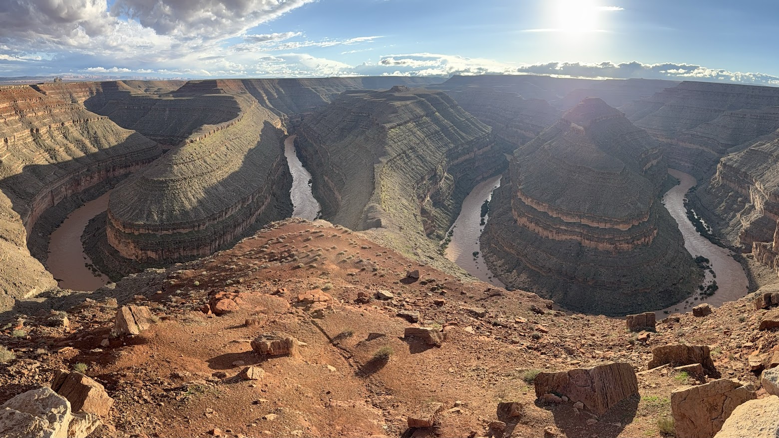
San Juan River from Goosenecks State Park
Courtesy & Copyright Eric Newell, Photographer
San Juan River from Goosenecks State Park
Courtesy & Copyright Eric Newell, Photographer
Rain in the desert heightens the senses.

My hands loosely grip the oars. My rain jacket is zipped to my beard, and my ball cap is pulled down tightly on my head. Standing on the floor of my raft, I lean gently on the oars, pushing the raft downriver on choppy, strong current. A gentle upriver breeze pushes against my face. Random raindrops pelt my cheeks. The sounds of the river sloshing and swirling fill the air. Wet rocks glisten and every hue is enhanced.
The river is swollen and running heavy with sediment from monsoon rains that have arrived both in the form of violent, lightning-charged microbursts and broad, regional storms.
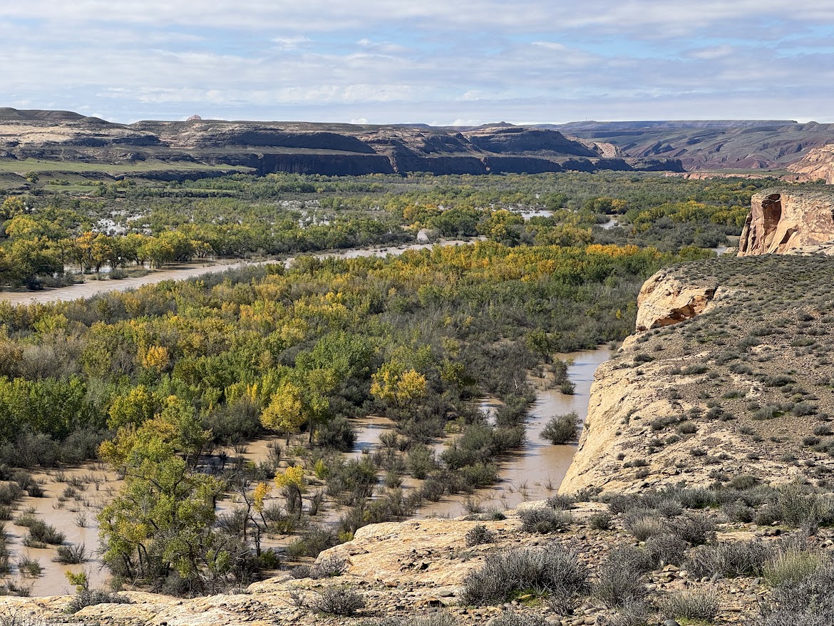
San Juan River Utilizing Its Floodplain Near Bluff Utah
Courtesy & Copyright Eric Newell, Photographer
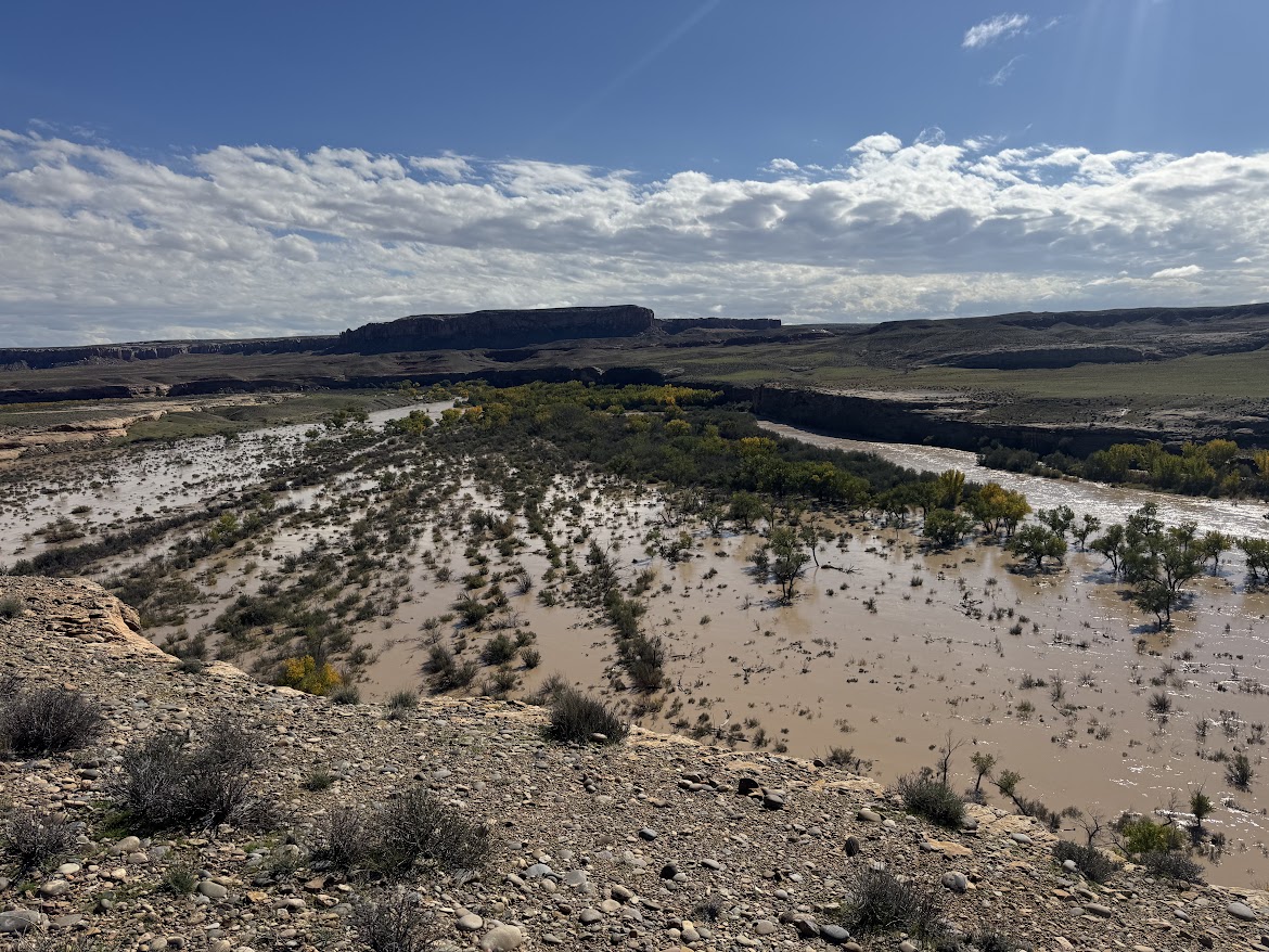
San Juan River Utilizing Its Floodplain Near Bluff Utah
Courtesy & Copyright Eric Newell, Photographer
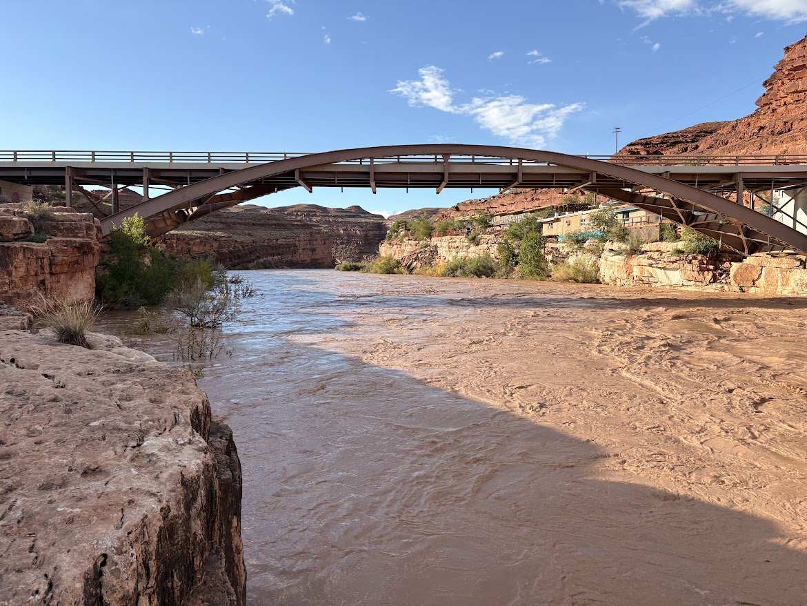
The water smells pungently of dirt and is so heavy-laden with silt that it looks more like rusty sludge than water. Deposits of fine sediment remain everywhere water has splashed, coating the raft, our feet, and our clothing with grime.

San Juan River Flood Plain Near Bluff Utah
Courtesy & Copyright Eric Newell, Photographer
San Juan River Flood Plain Near Bluff Utah
Courtesy & Copyright Eric Newell, Photographer
The swath of sky between the canyon walls is a steel-gray plate of mammatus clouds. It will be another wet evening in camp. I crane my neck and my eyes follow the edge of sky along the canyon rims. I am dwarfed by layers of limestone and shale that were laid down as sediment eons ago, then hardened to stone, then thrust upward by the unhurried, relentless forces of a continent in motion. All the while, the river cut through the uplift, eating away one grain of bedrock at a time, carving this canyon.

San Juan River In Mexican Hat At About 22000 CFS
Courtesy & Copyright Eric Newell, Photographer
San Juan River In Mexican Hat At About 22000 CFS
Courtesy & Copyright Eric Newell, Photographer
Beyond the clouds, I imagine billions of stars above—invisible in the daylight—and our vulnerable little planet traveling through the cosmos.

The pages of Lisa Kearsley’s San Juan River Guide, on the deck of my raft, have turned in the breeze. I could look up the geologic periods and names of the various layers—yet again. But right now, today, just being here, lost in the wonder and awe of this canyon, is enough. In the scope of geologic time, how did I get so lucky to be in this place, on this day, in this particular storm? This moment will be lost in the ages, but it is crystalized in time for me.

An ancestral Puebloan granary, concealed beneath an overhang, catches my attention. We drift past. No one else notices. A few bends later, a bighorn ram walks the edge of a ledge above the river. It pauses and turns its massive head to watch us drift along. People and creatures have inhabited this landscape for millennia. Each of us are just passing through.
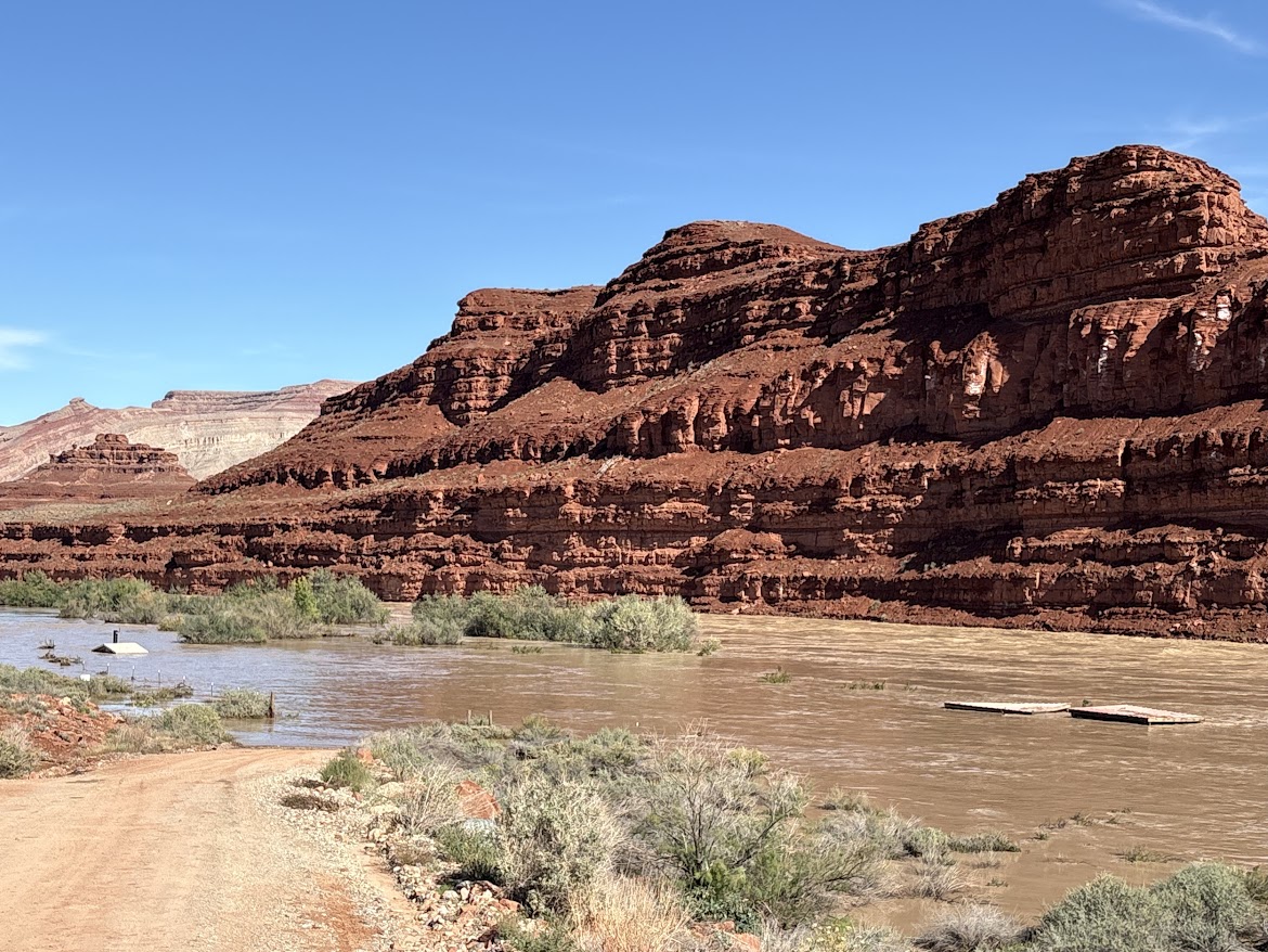
Mexican Hat Boat Ramp with the river running 41000 CFS
Courtesy & Copyright Anna Hart, Photographer
Mexican Hat Boat Ramp with the river running 41000 CFS
Courtesy & Copyright Anna Hart, Photographer
That was between Bluff and Mexican Hat, September 16, on about 4,000 cubic feet of water per second—or CFS.

A month later, on October 23, the San Juan Country Sheriff closed the river due to extreme high water. The river had breached several sewer treatment plants upstream and local agencies were overwhelmed mitigating flood damage. On October 26, the river peaked at about 41,000 CFS—flow levels not seen since the 1970’s. The river dropped to about 5,000 CFS for a few days, then peaked again at 34,000 CFS on November 3. Two separate fifty-year flood events occurred in an eight-day span, isolating and inundating communities in three states.

Above the river, on the outside bend of the canyon near mile sixteen, century-old cottonwood tree trunks, weathered to dark gray, rest one hundred and twenty feet above the river bottom. They were once adrift.

Analysis conducted by Lynn Orchard, under the direction of Bob Webb at the University of Arizona in 1999, indicate these logs were deposited by a flood in 1911. By radiocarbon dating debris from past floods in the canyon, they calculated the 1911 flood likely produced the largest flows in the lower San Juan canyons during the past 4,000 years, with maximum flows around 150,000 CFS.
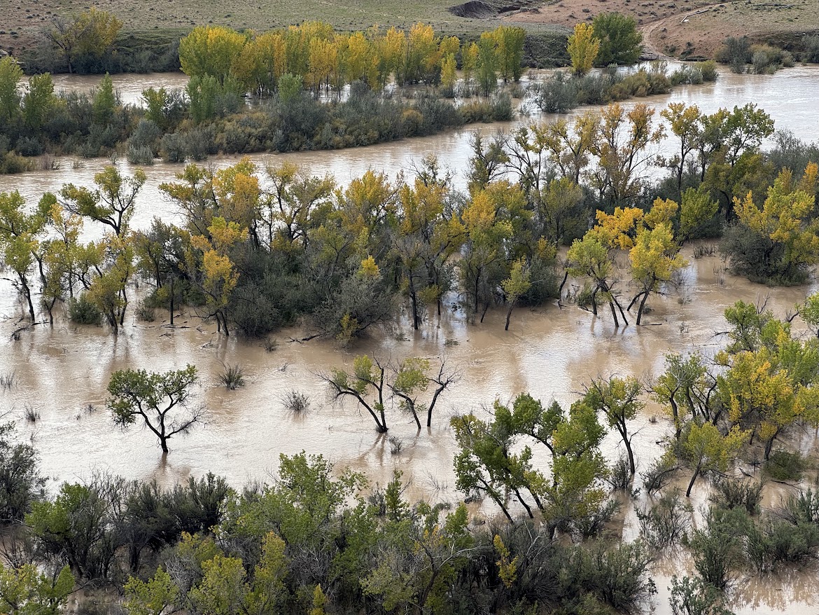
San Juan River Overflowing Its Banks
Courtesy & Copyright Eric Newell, Photographer
San Juan River Overflowing Its Banks
Courtesy & Copyright Eric Newell, Photographer
In an era of dams, diversions, and drought, watching the river overflow its banks and utilize its floodplain is a remarkable once-in-a-generation phenomenon. Every now and then the river rises up and reminds us that it has been here for eons, and will continue to run its course, carving its way through the canyons.

I am Eric Newell and I am wild about Utah and our wild rivers.

If you would like to contribute support for flood victims in and around Bluff, Utah, please consider https://bluffcommunityfoundation.org

Credits:

Images: Courtesy & Copyright Brandt & Anna Hart as well as Courtesy & Copyright Eric Newell
Featured Audio: Courtesy & Copyright © Friend Weller as well as J. Chase and K.W. Baldwin
Text: Eric Newell, Edith Bowen Lab School, Utah State University, https://edithbowen.usu.edu/
Voice: Eric Newell, Edith Bowen Lab School, Utah State University, https://edithbowen.usu.edu/

Additional Reading

A comprehensive look at the flooding, Explorer Vault, https://www.youtube.com/watch?v=JmxiGbdl0mQ

San Juan River Flows Near Bluff, Utah, USGS, https://waterdata.usgs.gov/monitoring-location/USGS-09379500/#dataTypeId=continuous-00065-0&period=P30D&showFieldMeasurements=true

The 1911 Four Corners Flood: Could it happen again? KUST, Four Corners Public Radio, https://www.ksut.org/history/2023-10-01/the-1911-four-corners-flood-could-it-happen-again

Orchard, Kenneth Lynn, Paleo Flood Hydrology of the San Juan River, The University of Arizona, https://repository.arizona.edu/items/b62d9d40-aede-4d19-9fc2-e837124bf4b6

How deep? Compare Sand Island Boat Launch images from Maps.Google.com with the 41000 CFS at Sand Island Boat Launch Gallery above, https://maps.app.goo.gl/xpzEHHa5k4Qtd7nr9

The Colorado River, a World-class Sculptor

Today’s story was written by Carlos Ramos, facilities director at Stokes Nature Center. I will be reading the English translation. To hear Carlos’s version in Spanish, you can find it online or listen Wednesday night at 9:01 p.m.

August arrived and the heat was at its peak. Summer was well established in Utah, and educational outings were making the most of the season. There is nothing better than leaving everyday life behind and spending a few days immersed in nature.

This last August, I went canoeing on the Green River with incoming freshmen of Utah State University and a few guides from the USU outdoor programs. The Green River is the main tributary of the Colorado River and stretches some 730 miles through Wyoming, Utah, and Colorado.

It is a brilliant, world-class sculptor, taking its time to shape magnificent red and orange sandstone mountains into unique, priceless works of art. During the late summer, the river is very calm, an excellent time to paddle. The journey becomes a time to listen, observe, sing the most off-key melodies, and learn about everything around us.

After five days, we learn that disconnecting from daily routines and worries about what might happen in the world makes us more attuned to nature, more observant, more creative, and more grounded.
One of the non-negotiable requirements of this trip was no technology. At first, I wondered how we could return to a time when we did not depend on cell phones and other communication systems, so we can enjoy the world around us.

After five days, we learn that disconnecting from daily routines and worries about what might happen in the world makes us more attuned to nature, more observant, more creative, and more grounded. As we realize that it does not take much to be happy.

Labyrinth Canyon is home to a wide variety of bird species and serves as a nesting sanctuary for peregrine falcons and golden eagles. You can see great blue herons and, of course, bald eagles as well as swallow nests on the immense walls of the colorful cliffs.

Mammals include beavers and otters, as well as larger mammals such as desert bighorn sheep, mule deer, coyotes, and foxes. On some days during this trip, we saw other nature lovers like us taking the time to enjoy fishing.
These dark, muddy waters are home to several federally protected fish native to Utah, including the Colorado pike minnow, the humpback chub, the bonytail chub, and the razorback sucker.

The banks of the Green River are adorned with trees such as willows and cottonwoods. In addition to adding a touch of beauty, their roots help stabilize sand bars, and they provide food and building material for beavers.

Above the canyons, the land is covered by a delicate living carpet of cyanobacteria, mosses, and lichens, known as cryptobiotic crust, which is vital for preventing erosion and fixing nutrients in the soil.

Night fell, and the camp began to take shape. Everyone pitched their tents, and dinner was prepared and enjoyed, accompanied by stories, games, and trivia amid laughter and murmurs. The hours passed slowly in this wonderful place, somewhere you never want to leave.

When darkness fully settled in, our guests of honor arrived. A night filled with lights, whose shapes and names leave even the greatest dreamer pondering. The stars made their majestic entrance, tracing even the unimaginable across the sky, where creativity can discover 1000s upon 1000s of shapes. We waited for a glimpse of the Milky Way, and of course, the Queen of the Night, the Moon.

If I could wish for time to stand still, I would choose this place without hesitation, in the company of people as special as these traveling companions. They will forever be among the 1000s of explorers who have journeyed through these beautiful treasures of a wild Utah.

The story was written by Carlos Ramos, a Utah naturalist with a passion for the nature of this incredible planet, and he is definitely Wild About Utah.

Lakes

USGS scientist Robert Baskin takes a boat out on the Great Salt Lake to conduct research
Courtesy USGS, Jennifer LaVista, Photographer
USGS scientist Robert Baskin takes a boat out on the Great Salt Lake to conduct research. Baskin is best known for his innovative research on Great Salt Lake, collaborating with the Scripps Institute of Oceanography and University of Utah to provide information vital for effective lake management.
Courtesy USGS, Jennifer LaVista, Photographer
I’m a lake person born in the Great Lakes region, land of Hiawatha’s “shining big sea waters”. Fishing, hunting, swimming, and boating were at the center of our culture.

Now having lived three fourths of my life in Utah, I’ve found it a well-watered desert with all descriptions of lakes from the intermittent, seasonal, inches deep Sevier Lake to the plunging depths of Bear lake. Utah’s Great Salt Lake has brought us international acclaim, more than any other physical feature, as the Great Lakes have to Michigan. Following the Jordan River a relatively short distance upstream from the Great Salt Lake, freshwater Utah lake glitters in the sun, once thriving with monster Bonneville cutthroat trout, coveted by native peoples and pioneers alike.

Aerial view of Bear Lake, USGS boat, and employees on a water-quality platform, Courtesy USGS, Jake Seawolf,Photographer, (Volunteer for USGS, full-time professional photographer for the US Army.
Aerial view of Bear Lake, USGS boat, and employees on a water-quality platform
Courtesy USGS, Jake Seawolf, Photographer, (Volunteer for USGS, full-time professional photographer for the US Army.

Fish Lake, Courtesy USDA Forest Service Fish Lake
Courtesy USDA Forest Service

Moving to our northern border the turquois Bear Lake beauty startles the senses. A tectonic, earth fractured lake over a quarter millennium old, it is uniquely different from our other naturally occurring lakes, which were created during the last ice age, many formed less than 12,000 years ago.

Heading south, you will find the dazzling Fishlake, our largest high-altitude lake, six miles in length, a mile wide, approaching 9000’ elevation.

Beyond these, our Uintah Mountains are dappled with a head spinning thousand plus glacial lakes, ranging in size from the 1200 acre Mirror Lake to the half acre Boulder tarn lake. (tarn: a small mountain lake) Most occur above 10,000 feet elevation.

“Gods eye” wrote Herny David Thoreau describing Waldon Pond. I often sense the same as I peer into the crystalline depths of our pristine glacial lakes.

Our many artificial reservoir lakes are the most highly visited providing endless pleasure and relief from summer heat. Often their beauty is unmatched for artificial lakes, Flaming Gorge, Lake Powell, Jordanelle, Pineview, Sand Hollow to name a few.

A bit of lake ecology. There are four major categories of lakes from the deep, cold, low productive Oligotrophic like Bear lake, to the highly acidic, dystrophic bog lakes found in the Uintah high country containing little aquatic life. Between are the mesotrophic- Pine View reservoir, Willard Bay, and the eutrophic, highly fertilizer enriched Utah Lake, often suffering from algae blooms, which are becoming more common with a warming climate.

Our deeper lakes enjoy a spring and fall phenomenon called “overturn”. Deeper lakes experience stratification, or stagnation, similar to our atmospheric inversions, with warmer water sitting on top, and colder, heavier water toward the bottom. This causes an oxygen deficit in lower layers, and nutrient deficiency in the upper layers. Once water reaches its highest density of 39.2 degrees Fahrenheit, which occurs during spring warm up and fall cool down, the surface water will sink, forcing nutrients from the depths upward, and bring oxygen from the surface downward. This mixing favors aquatic life from top to bottom of the water column, a joyous occasion!

This is Jack Greene for Bridgerland Audubon Society, and I am Wild About Utah’s Great Lakes.

Credits:

Picture: Great Salt Lake and Bear Lake, Courtesy USGS, Fish Lake Courtesy USDA Forest Service
Audio: Courtesy & © Kevin Colver https://wildstore.wildsanctuary.com/ and Anderson, Howe and Wakeman.
Text: Jack Greene, Bridgerland Audubon, https://bridgerlandaudubon.org/
Additional Reading: Lyle W Bingham, Webmaster, and Jack Greene, Author, Bridgerland Audubon, https://bridgerlandaudubon.org/

Additional Reading:

Jack’s Wild About Utah pieces.

Judd, Harry Lewis, Utah’s Lakes and Reservoirs, Inventory and Classification of Utah’s Priority Lakes and Reservoirs, Utah Department of Environmental Quality, January 1997, https://lf-public.deq.utah.gov/WebLink/ElectronicFile.aspx?docid=458257

Utah’s Priority Lakes and Reservoirs 1999: Watershed Management Program, Utah Department of Environmental Quality, https://deq.utah.gov/water-quality/watershed-protection/utahs-priority-lakes-and-reservoirs-1999-watershed-management-program

Utah’s 1982 Priority Lakes and Reservoirs List from “Judd” above.
Each lake name is linked to a Google map:

Anderson Meadow Reservoir
Ashley Twin Lakes
Baker Dam Reservoir
Barney Lake
Bear Lake
Beaver Meadow Reservoir
Big East Lake
Big Lake
Big Sand Wash Reservoir
Birch Creek Reservoir #2
Blanding City Reservoir#4
Bridger Lake
Brough Reservoir
Browne Reservoir
Butterfly Lake
[Zelph] Calder Reservoir
Causey Reservoir
China Lake
Cleveland Reservoir
Cook Lake
Currant Creek Reservoir
Dark Canyon Lake
Deer Creek Reservoir
DMAD Reservoir
Donkey Reservoir
Duck Fork Reservoir
East Canyon Reservoir
East Park Reservoir
Echo Reservoir
Electric Lake
Fairview Reservoir #2
Ferron Reservoir
Fish Lake
Flaming Gorge Reservoir
Forsyth Reservoir
Grantsville Reservoir
Gunlock Reservoir
Gunnison Bend Reservoir
Gunnison Reservoir
Hoop Lake
Hoover Lake
Huntington Lake North
Huntington Reservoir
Hyrum Reservoir
Joes Valley Reservoir
Johnson Valley Reservoir
Jordanelle Reservoir
Kens Lake
Kents Lake
Kolob Reservoir
Koosharem Reservoir
Labaron Reservoir
Lake Mary
Lake Powell
Little Creek Reservoir
Little Dell Reservoir
Lloyds Reservoir
Long Park Reservoir
Lost Creek Reservoir
Lower Bowns Reservoir
Lower Box [Creek] Reservoir
Lower Gooseberry Reservoir
Lyman Lake
Manning Meadow Reservoir
Mantua Reservoir
Marsh Lake
Marshall Reservoir
Matt Warner Reservoir
Meeks Cabin Reservoir
Mill Hollow Reservoir
Mill Meadow Reservoir
Miller Flat Reservoir
Millsite Reservoir
Minersville Reservoir
Mirror Lake
Mona Reservoir
Monticello Lake
Moon Lake
Navajo Lake
Newcastle Reservoir
Newton Reservoir
Nine Mile Reservoir
Oak Park Reservoir
Otter Creek Reservoir
Palisades Lake
Panguitch Lake
Paradise Park Reservoir
Pelican Lake
Pine Lake
Pineview Reservoir
Piute Reservoir
Porcupine Reservoir
Posey Lake
Puffer Lake
Pyramid Lake
Quail Creek Reservoir
Recapture Reservoir
Red Creek Reservoir
Red Creek Reservoir (Iron)
Red Fleet Reservoir
Redmond Lake
Rex’s Reservoir
Rockport Reservoir
Rush Lake
Salem Pond
Scofield Reservoir
Scout Lake
Settlement Canyon Reservoir
Sevier Bridge Reservoir [a.k.a. Yuba Reservoir]
Sheep Creek Reservoir
Smith and Morehouse Res
Spirit Lake
Stansbury Lake
Starvation Reservoir
Stateline Reservoir
Steinaker Reservoir
Strawberry Reservoir
Three Creeks Reservoir
Tibbie Fork Reservoir
Tony Grove Reservoir
Trial Lake
Tropic Reservoir
Upper Enterprise Reservoir
Upper Stillwater Reservoir
Utah Lake
Wall Lake
Washington Lake
Whitney Reservoir
Wide Hollow Reservoir
Willard Bay Reservoir
Woodruff Creek Reservoir
Yankee Meadow Reservoir

Bass, Birds, Buddies, and Boats

Joey, James & Jack Courtesy Joseph Kozlowski & Copyright Jack McLaren, Photographer
Joey, James & Jack
Courtesy Joseph Kozlowski & Copyright Jack McLaren, Photographer

Wilson's Phalarope
Courtesy & Copyright Joseph Kozlowski, Photographer
Wilson’s Phalarope
Courtesy & Copyright Joseph Kozlowski, Photographer

Banana Boy James, Courtesy Joseph Kozlowski & Copyright Jack McLaren, Photographer Banana Boy James
Courtesy Joseph Kozlowski & Copyright Jack McLaren, Photographer

I sit on the front swivel seat of a drift boat gliding across the smooth water of Newton Reservoir. The sun begins to send morning rays of brilliance over the Cache Mountains. My only child, a 14-month-old boy named James, excitedly wriggles in my lap. Behind me in the captain’s seat is my long-time buddy, Jack McLaren. Jack and I met in graduate school where he was working on a doctorate in watershed sciences and fish ecology. Jack and I have been friends ever since, and any day fishing with Jack is one I cherish.

Jack tells me the Largemouth Bass are on the other end of the reservoir, in the shallow, weedy water where they feast on any living creature they can find, primarily small Bluegill who nest in that area. Using two oars, Jack begins paddling the boat across the reservoir. James’ eyes are mesmerized by the turbulent water eddies that form around the oars with each stroke, and I peacefully observe the world and wings around me. Western Kingbirds, with their gentle yellow bellies and grey head, play chase games as they dive and duck from one cottonwood tree to another on the water’s edge; Bank Swallows make clicking and clacking noises like pulsing electrical wires from the steep muddy embankment where a healthy colony has formed; and Wilson’s Phalaropes do a mating display where the modestly colored male hovers in the air over the brightly colored female, bobbing up and down for nearly 5 seconds, before gently landing next to her.

We reach the far end of the reservoir and begin fishing. Jack pulls a plastic green frog across the top of the water; I bounce a long, brown rubber worm with a neon tail under the water; and James, well, he grabs each bag of rubber worms from the tackle box and throws them over the side of the boat.

Just as I finally distract James with a Banana, “THWAPPP!!” a splash sounds and a commotion in the water catches my attention. A hungry bass thought frogs were on the menu and was fooled by Jack’s lure. He reels in the bass and James and I look at the beautiful, greenish/yellowish creature with the distinguishable black stripe down the side. James, with a mischievous smile, courageously reaches out his pointer finger and gently runs it along the slimy, scaly body of the fish.

We continue to fish and just take in the beautiful morning when the thought strikes me.

“This little 14-month-old is going to be my new, best buddy for the rest of my life. Observing, respecting, being aware of, and appreciating nature has always been important to me. How do I pass this same kind of love and respect for nature onto my own son, the next generation, as my father and mother did to me?”

To that, I don’t have an answer, but maybe, just maybe, James being mesmerized by the flow of swirling water eddies around oar paddles or him using his delicate finger to bravely stroke the side of a slimy fish may be just the right start.

This is Dr. Joseph Kozlowski, and I am Wild About Utah!

Credits:

Images: Courtesy & Copyright Joseph Kozlowski, Photographer, Used by Permission
Featured Audio: Courtesy & Copyright © Kevin Colver, https://wildstore.wildsanctuary.com/collections/special-collections/kevin-colver and including contributions from J. Chase and K.W. Baldwin
Text:     Joseph Kozlowski, Edith Bowen Laboratory School, Utah State University https://edithbowen.usu.edu/
Additional Reading Links: Joseph Kozlowski & Lyle Bingham

Additional Reading:

Joseph (Joey) Kozlowski’s pieces on Wild About Utah:

Experiential Education Archives, Wild About Utah https://wildaboututah.org/tag/experiential-education/

Hitchcock, Ed, 7 Tips for Fishing with Kids, Take Me Fishing, the Recreational Boating & Fishing Foundation, Nov 22, 2019, https://www.takemefishing.org/blog/november-2019/7-tips-for-fishing-with-kids/

Community fisheries, Division of Wildlife Resources, Department of Natural Resources, State of Utah, Last Updated: September 12, 2024, https://wildlife.utah.gov/community-fisheries.html