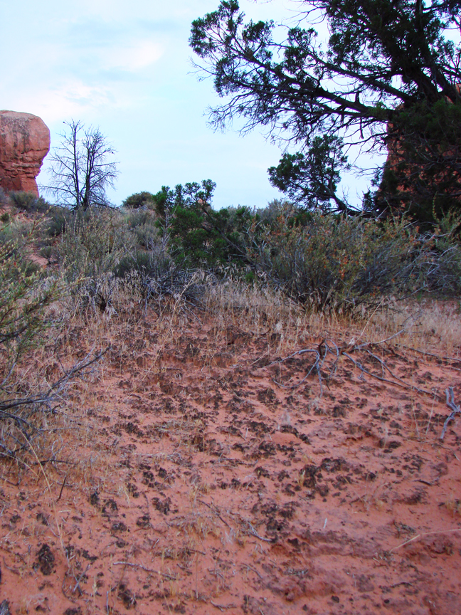
Cryptobiotic Soil Crusts

Click to view larger image of Cryptobiotic Soil Crust, Photo Courtesy and Copyright Mark Larese-Casanova
Cryptobiotic Soil Crust
Photo Courtesy & Copyright 2009
Mark Larese-Casanova

Hi, this is Mark Larese-Casanova from the Utah Master Naturalist Program at Utah State University Extension.

Looking out over a Utah desert, we might see relatively few plants- perhaps some sagebrush, maybe a few junipers or Joshua trees, or even some small wildflowers or cacti. What is less noticeable, though, is the living soil crust that holds this entire landscape together. It’s not just sand, but rather an important and vast partnership between bacteria, lichens, algae, and fungi. These soil crusts are often referred to as ‘cryptobiotic’, which means ‘living in suspended animation’. This is a fitting description, considering that water can be so rare in Utah’s deserts.

Cyanobacteria, which is often called blue-green algae, is the backbone of cryptobiotic soil crust. Vast networks of long, microscopic filaments of cyanobacteria and fungi grow in length when they are wet, and leave behind a casing that literally binds the soil together. So, what might otherwise be loose sand not only is less likely to be washed away by water or blown away by wind, but also is able to hold much more water for plants.
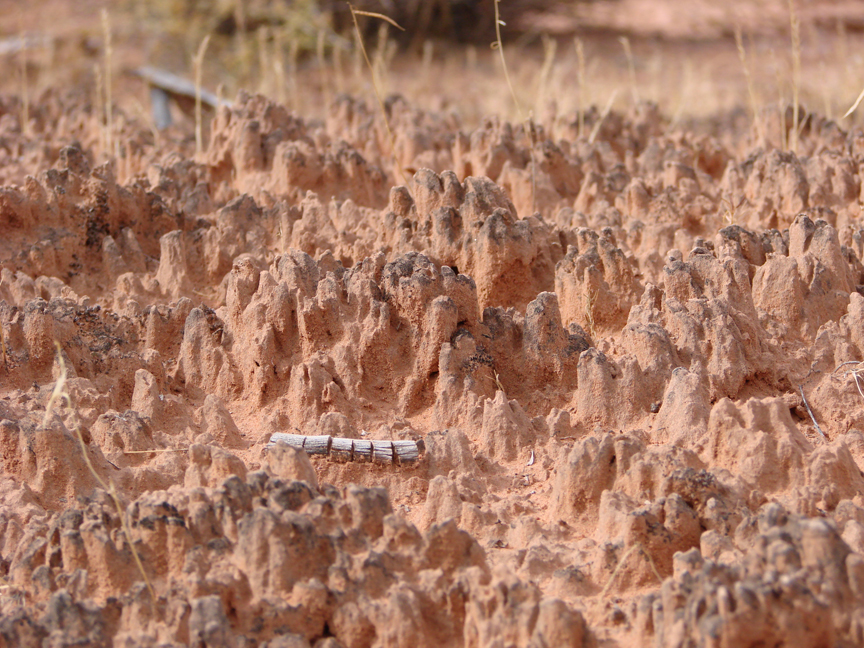
Click to view larger image of Cryptobiotic Soil Crust, Photo Courtesy and Copyright Mark Larese-Casanova
Cryptobiotic Soil Crust
Photo Courtesy & Copyright 2009
Mark Larese-Casanova

Cyanobacteria is also extremely useful to desert landscapes for its ability to take Nitrogen out of the air and make it available to plant roots in the soil. Desert soils typically have relatively low nutrients, so this is especially important to desert plants.

In many Utah deserts, cryptobiotic soil crusts can cover up to 70% of the ground surface. Old soil crust can often look like small mountain ranges with black or white peaks inhabited by lichens or mosses. The little valleys in between the tiny mountains of crust are perfect spots for the seeds of desert plants to grow. Over time, the above ground crust can grow up to ten centimeters, or four inches, thick!

However, cryptobiotic soil crust grows at an alarmingly slow rate of about one millimeter per year. So, any soil crust that is disturbed can take a very long time to recover. Depending on the amount of moisture a desert receives, it can take anywhere between 20 and 250 years for soil crust to grow back.

Next time you’re out in the desert, kneel down and have a close look at the telltale peaks and valleys of cryptobiotic soil crust. If you bring a magnifying glass, you just might be able to see some of the lichens and mosses. Be sure to stay on trail, though, and whatever you do, don’t bust that crust!

For Wild About Utah, I’m Mark Larese-Casanova.

Credits:

Images: Courtesy and copyright Mark Larese-Casanova
Text:     Mark Larese-Casanova, Utah Master Naturalist Program at Utah State University Extension.
Additional Reading:

US Department of Interior. 2001. Biological Soil Crusts: Ecology and Management. Bureau of Land Management Technical Reference 1730-2., https://www.blm.gov/nstc/library/pdf/CrustManual.pdf
Rosentreter, R., M. Bowker, and J. Belnap. 2007. A Field Guide to Biological Soil Crusts of Western U.S. Drylands. U.S. Government Printing Office, Denver, Colorado., https://www.soilcrust.org/
Oolites

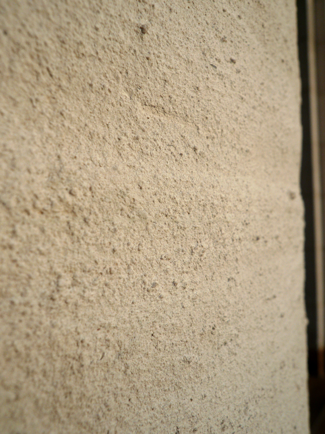
Click to view larger image of the Utah's Oolitic Sand, Photo Courtesy and Copyright Mark Larese-Casanova
Utah’s Oolitic Sand, Photo Courtesy and Copyright Mark Larese-Casanova

Hi, this is Mark Larese-Casanova from the Utah Master Naturalist Program at Utah State University Extension.

Imagine if prehistoric brine shrimp were responsible for one of the finest examples of architecture in Salt Lake City today.

Okay, so it may be a bit of a stretch, but let me explain. In a previous episode of Wild About Utah, I discussed the life cycle of brine shrimp and the important role that they play in the Great Salt Lake Ecosystem. Well, as the billions of brine shrimp feed on bacteria in Great Salt Lake, they excrete waste in the form of tiny fecal pellets. These pellets, along with sand grains and other bits of debris, eventually settle to the bottom of Great Salt Lake.

In shallow areas of the lake, where wind and waves routinely mix the water, these small particles gradually accumulate layers of calcium carbonate, forming an oolite (spelled o-o-l-i-t-e). This is very similar to how a pearl, also layers of calcium carbonate around a small particle, is formed within the shell of an oyster or mussel. The main difference, aside from a pearl being much larger, is that oolites are typically oblong, rather than round. The beaches on the west side of Antelope Island are a great place to find oolitic sand, which will look and feel as though you have a handful of tiny pearls.

Click to view larger image of the Utah's Oolitic Sandstone, Photo Courtesy and Copyright Mark Larese-Casanova
Utah’s Oolitic Sandstone
Photo Courtesy & Copyright
Mark Larese-Casanova

Around 50 million years ago, large fresh- and salt-water lakes covered parts of Utah, and in these areas, vast amounts of sediments, including oolites, were deposited. Over time, these oolites were compressed and cemented together into limestone.

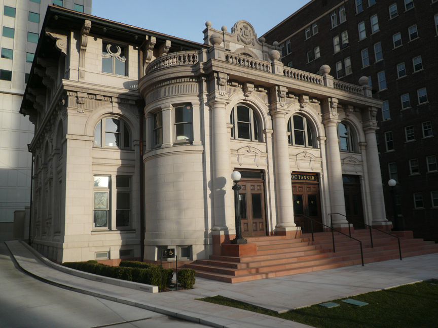
A quarry near Ephraim in Sanpete County supplied oolitic limestone for the construction of the Governor’s Mansion in 1902 and the original Salt Lake City Public Library in 1905. The Library building, located at 15 South State Street, eventually housed the Hansen Planetarium and is now home to the O.C. Tanner flagship store. The building underwent an extensive restoration just a couple of years ago, and now serves as a shining example of neoclassical architecture in our capitol city.

The truth is, there are tens of millions of years separating oolitic limestone from our modern-day brine shrimp. So, we can’t exactly say that prehistoric brine shrimp were responsible for the existence of the O.C. Tanner building. But, it’s fun to imagine precious gems from around the world housed in a beautiful building constructed from the ‘pearls’ of Great Salt Lake.

Click to view larger image of the historic OC Tanner building made from oolitic sandstone (This building formerly housed the Salt Lake Library and Hansen Planetarium), Photo Courtesy and Copyright Mark Larese-Casanova
Historic OC Tanner Building
(formerly the Salt Lake Library
and later the Hansen Planetarium)
Photo Courtesy & Copyright
Mark Larese-Casanova

For Wild About Utah, I’m Mark Larese-Casanova.
Credits:

Images: Courtesy and copyright Mark Larese-Casanova

Text:     Mark Larese-Casanova, Utah Master Naturalist Program at Utah State University Extension.
Additional Reading:

Utah Geological Survey https://geology.utah.gov/utahgeo/rockmineral/collecting/oolitic.htm

Utah Division of Wildlife Resources, Great Salt Lake Ecosystem Program
https://wildlife.utah.gov/gsl/facts/oolitic_sand.php

Salt Lake Brine Shrimp, https://saltlakebrineshrimp.com/harvest/

Why is it Colder at Higher Elevations?

The age old question: Why is it Colder at Higher Elevations? Click to view a larger photograph of view from the Nebo Loop, Photo Courtesy and Copyright Lyle Bingham
It is cooler at higher altitudes
Looking Southeast from the Nebo Loop
Photo Courtesy & Copyright 2011
Lyle Bingham

Hi, this is Mark Larese-Casanova from the Utah Master Naturalist Program at Utah State University Extension.

If the old saying that “hot air rises” is true, then why is it colder at the top of a mountain? Let’s think about it in terms inflating a bicycle tire. If we were to use a bicycle pump, it would compress the surrounding air to a greater pressure as the tire is inflated. This causes air molecules to collide at a greater rate, releasing energy in the form of heat. As a result, the bicycle pump would feel warmer to the touch.

Alternatively, if a CO2 cartridge is used to inflate the tire, compressed air is released, resulting in a cooling effect as molecules rapidly move farther apart. On a warm day, the CO2 cartridge will feel cold to the touch, even frosty. So, the greater the air pressure, the warmer the temperature.

The air around us doesn’t feel like it weighs much, but it’s obvious that it has some mass whenever a helium balloon is released. The balloon, filled with a gas that is lighter than the air in our atmosphere, floats up into the sky. If we think about the amount of air sitting on top of the ground at Utah’s lowest elevation of 2,178 feet above sea level at Beaver Dam Wash in the southwest corner of the state, and compare it to Utah’s highest elevation of 13,538 feet at King’s Peak, that’s an extra 11,360 feet of air! As a result, air pressure is about one and a half times as much at Beaver Dam Wash as it is at King’s Peak. With that increased pressure at lower elevations comes increased temperatures. In fact, with every thousand feet lower in elevation, average temperatures increase about 3.5 degrees Fahrenheit.

On average, annual temperatures are about 15 degrees Fahrenheit warmer in Salt Lake City than up at the Town of Alta, just ten miles up Little Cottonwood Canyon. Even early pioneers noticed this, and decided to settle along the warmer foothills of the Wasatch Mountains. To this day, most of Utah’s population along the Wasatch Front benefits from longer growing seasons and lower heating bills, while taking advantage of higher, cooler elevations for hiking on a summer day or skiing in winter.

For Wild About Utah, I’m Mark Larese-Casanova.

Credits:
Images: Courtesy and Copyright Mark Larese-Casanova
Text:     Mark Larese-Casanova

Additional Reading:

Altitude.org Air Pressure Calculator. https://www.altitude.org/air_pressure.php

If hot air rises, why is it cold in the mountains? Colorado State University Little Shop of Physics. https://littleshop.physics.colostate.edu/tenthings/ExpansionCooling.pdf

Joule-Thomson Effect. Princeton University. https://www.princeton.edu/~achaney/tmve/wiki100k/docs/Joule%E2%80%93Thomson_effect.html

Utah’s basement — Beaver Dam Wash is state’s lowest elevation. Deseret News. Sept. 3, 2006. https://www.deseretnews.com/article/645197370/Utahs-basement–Beaver-Dam-Wash-is-states-lowest-elevation.html?pg=all

Western Regional Climate Center. https://www.wrcc.dri.edu/

SNOTEL Snowpack Recording Stations

Manual Snow Measurement
Cover image from
Snow surveying by James C. Marr
USDA 1940 Publication 380
Public Domain
Courtesy UVA, Google & HathiTrust

For a modern view visit
https://www.meted.ucar.edu/afwa
/avalanche/print.htm

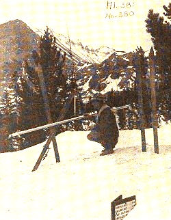
Removing snow surveying apparatus
from canvas carrying case
preparatory to use
From
Snow surveying by James C. Marr
USDA 1940 Publication 380
Public Domain
Courtesy UVA, Google & HathiTrust

Water is a precious resource throughout the world. Most of Utah consists of arid habitats and many users clamor for their share of the scarce moisture. Ever-growing demand challenges water managers to insure that agriculture, cities and nature all get their portion. Predicting and monitoring stream flow is imperative in order to know how much to hold in reservoirs or send downstream, and when to anticipate floods, enact water conservation measures, and in general provide for all users.

Much of Utah’s water originates in the mountain snowpack. Early in the twentieth century, the Department of Agriculture constructed a series of Snow Courses in mountainous areas of the West. Hardy personnel periodically trekked in to measure snow depth with a long ruled stick. Water content was found by taking a core sample, weighing it and subtracting out the weight of the metal tube. Stream gauging stations installed by the US Geological Survey allowed correlation of stream flows with snowpack measures.

In the 1970’s, monitoring snow courses became more automated. The reporting stations were named “SNOTEL” for snowpack telemetry. Now there are over 600 SNOTEL sites in 13 western states. The measurement functions of SNOTEL stations are elegantly simple and reliable. Air and soil temperatures are monitored with standard thermocouples. Water content of the snowpack is measured by its weight atop a broad thin bladder called a snow pillow that is filled with antifreeze. The snow pillow is carefully spread on the ground. Accumulating snow presses down on the pillow, pushing some antifreeze out a connecting tube to a pressure sensor.

Some SNOTEL sites also measure snow depth, using the autofocus technology of the digital camera. Subject distance is gauged by the time delay of an ultrasonic pulse, like sonar or hearing your voice echo back in a canyon. At a SNOTEL station, a similar sensor is placed high above the expected snow line. As snow accumulates, the downward facing sensor reports the shortening distance between it and the snow surface.

SNOTEL stations have batteries and a solar panel to power their hourly data transmissions. Ogden has one of the two master receiving stations. Want to size up mountain snowfall from the last storm or know how warmly to dress for an outing? Just go to Utah’s SNOTEL information site on the web.

Credits:

Image: Public Domain, Courtesy University of Virginia, Google and HathiTrust, Cover image from Snow surveying by James C. Marr, USDA 1940 Publication 380

Text: Jim Cane & Linda Kervin, Bridgerland Audubon Society https://www.bridgerlandaudubon.org

Additional Reading:

Water Conservation Begins with Snow Surveys, USDA NRCS, https://www.wcc.nrcs.usda.gov/factpub/wc_ss.html

Snow Hydrology: SNOTEL, Randall Julander, Civil & Environmental Engineering, University of Utah, (formerly at https://www.civil.utah.edu/~cv5450/snotel/snotel.htm)

Utah Snow Survey Program, USDA NRCS, https://www.ut.nrcs.usda.gov/snow/

NRCS Snow Surveyor Collects Vital Water Data, Lives Dream Job, Spencer Miller, NRCS, Jan 10, 2013, https://www.nrcs.usda.gov/wps/portal/nrcs/detail/national/home/?cid=STELPRDB1076993

Snow Surveys and Water Supply Forecasting, National Atlas of the United States, US Department of the Interior, https://www.wcc.nrcs.usda.gov/factpub/sect_4a.html

Map, Utah USGS SNOTEL Stations https://www.wcc.nrcs.usda.gov/snotel/Utah/utah.html