Hot Springs

Utah Hot Springs
Click map for larger view
Map by H. Strand, Data from
Blackett and Wakefield 2002.
Hi, I’m Holly Strand from Stokes Nature Center in beautiful Logan Canyon.

Cold weather getting to you? Can’t swing a trip to Hawaii or the Carribean this year?

Fortunately for us, there’s a natural antidote to winter right here in Utah Hot springs abound in the Beehive State. According to a Utah Geological Survey database, there are 106 known springs with waters above 25 degrees Celsius or 77 degrees Fahrenheit. The hottest temperature recorded in a Utah spring is 91 degrees Celsius or 195 degrees Fahrenheit at Crystal Hot Springs in Salt Lake County.

Hot springs develop when rain and melted snow infiltrate into the ground. This ground water then sinks deep enough to be warmed by the heat contained in the earth’s interior. Because hot water is less dense it is pushed back to the surface by the continued sinking of incoming heavier, cold water. Replenishment through surface precipitation creates a continuous cycle.

Why do some areas have hot springs and others do not? While there is heat in the earth beneath any spot on the surface, in some areas, this heat is concentrated closer to the surface. For instance, in and around volcanoes–this is the case in Yellowstone area.

Luckily, we don’t know of any volcanoes lurking beneath us. But we know that the Basin and Range area of western Utah, southeastern Idaho, Nevada and eastern California, is expanding or spreading. This spreading movement leaves a relatively thin crust. And a thinner crust means heat is closer to the surface. Furthermore, crustal movement create surface faults that allow cold water to seep down and warm water to flow out. Thus with few exceptions, the higher temperature geothermal areas in Utah occur either in the Basin and Range Province or within the Basin and Range-Colorado Plateau transition zone.

Geothermal sources have many practical uses. The Blundell power station at the Roosevelt Hot Springs geothermal area near Milford produces commercial energy. There are several greenhouses and aquaculture facilities in Utah using geothermal resources. But my favorite application of geothermal waters would be the hot spring spa or swimming pool. Soakersbible.com lists 16 of these in Utah. And for those of us in northern Utah there’s at least ten more right across the border in Idaho.

For maps and sources of information on hot springs and spas, see Wildaboututah.org.
Thanks to the Lion’s Gate Manor in Lava Hot Springs for supporting research and development of this Wild About Utah topic.

For Wild About Utah and Stokes Nature Center, I’m Holly Strand.
Credits:

Images: Map by H. Strand, Data from Blackett and Wakefield 2002.

Text:     Holly Strand, Stokes Nature Center

Sources & Additional Reading:

Blackett, R.E., and Wakefield, S.I., 2002, Geothermal resources of Utah, a digital atlas of Utah’s geothermal resources: Utah Geological Survey, OFR-397, CD-ROM. Available online https://ugspub.nr.utah.gov/publications/open_file_reports/ofr-431/ofr-431_geothermal-resources-utah.pdf

https://geology.utah.gov/map-pub/maps/interactive-maps/wells-springs/ [Updated February 1, 2026]

Blackett, R.E. Utah Geothermal Wells & Springs Interactive Map. 1:500,000. Utah Geological Survey, Cedar City Office. https://geology.utah.gov/publication-details/?pub=OFR-431dm. [ Updated February 1, 2026]

DeTar, R.E. Thermal Waters. Digital Atlas of Idaho. https://www.isu.edu/digitalatlas/ [ Updated February 1, 2026]

Oregon Institute of Technology. Geothermal Resources of Utah. Geo-Heat Center Quarterly Bulletin Vol. 25. No. 4. https://www.oit.edu/docs/default-source/geoheat-center-documents/quarterly-bulletin/vol-25/25-4/25-4-bull-all.pdf[ accessed January 10, 2010, Viable target not found February 1, 2026]

Utah Geological Survey. Geothermal Occurrences in Utah. https://www.geology.utah.gov/emp/geothermal/geothermal_occurrences_in_utah.htm

Major Thermal Springs of Utah, Utah Geological Survey, https://ugspub.nr.utah.gov/publications/water_resources_bulletins/WRB-13.pdf

Travel:
Lion’s Gate Manor in Lava Hot Springs. (208) 776-5118 https://www.lionsgatemanor.com/index.html

The Soakers Bible: the definitive guide to hot springs and natural spas in the Western United States. https://www.soakersbible.com/ [Removed May 27, 2018, Website Terminated]

Geothermal Springs in Idaho, https://www.energy.idaho.gov/renewableenergy/recreation.shtml
Replaced with Geothermal Resources in Idaho, https://oemr.idaho.gov/wp-content/uploads/2016/06/geothermal_book_complete_2007.pdf [Added February 1, 2026]


Utah Lobster Étouffée

Click to view larger image Northern Crayfish Orconectes virilis. Photo Copyright 2009 Ellen Wakely
Northern Crayfish Orconectes virilis
© 2009 Ellen Wakely

Hi, I’m Holly Strand from Stokes Nature Center in beautiful Logan Canyon.

Remember this song?:

You get a line and I’ll get a pole honey
You get a line and I’ll get a pole, babe
You get a line and I’ll get a pole
And we’ll go down to the crawdad hole
Honey, baby mine

Did you know you that the “Crawdad Song” is relevant for Utahns? Not long ago, I encountered a rocky stream just teeming with crayfish.

Crawfish, crawdaddies, freshwater lobsters and mudbugs are all different names for the same little creature. Like a lobster, the crayfish has a joined head and midsection, and a segmented body. Crayfish come in assorted colors: sandy yellow, green, white, pink or dark brown. And they are usually about (3 inches) long.

Crayfish conceal themselves under rocks or logs. They are most active at night, when they feed on snails, algae, insect larvae, worms, and other delicacies.

There are about 330 different species that occur in North America. They are especially concentrated in the southern Mississippi Basin. Utah has only one native—the pilose crayfish. Its range is in northern Utah’s Bear River, Weber River and Ogden River drainages and in the Raft River Mountains drainages.

Utah also has two known invasive crayfish, The northern crayfish is a very successful and aggressive species. It was introduced and stocked in the 60’s and 70’s and is increasingly widespread. These crayfish are particularly abundant in Flaming Gorge and Glen Canyon reservoirs and in the Virgin and Duchesne drainages. The Louisiana crayfish has also found its way to Utah. This is the culinary crayfish that you ‘ve probably encountered in jambalaya and crawfish étouffée.

Nonnative crayfish infestations degrade freshwater habitats if the new crayfish outcompetes natives. Invasives also carry disease. Too many crayfish can destabilize stream banks by digging and burrowing.

In controlled quantities and locations crayfish provide wonderful food for fish, birds and people too. You can catch crayfish with
chunks of meat or fish. They are attracted to the odor.

Anyone with a valid Utah fishing or combination license may take crayfish for personal use during the open fishing season set for the given body of water. Just make sure you don’t transport any live crayfish away from the body of water where taken.

Thanks to The ToneWay Project at Toneway.com for their rendition of the crawdad song.
And to Dr. Scott Miller of the College of Natural Resources Bug Lab at Utah State University.

For Wild About Utah and Stokes Nature Center, I’m Holly Strand.

Credits:

Images: © 2009 Ellen Wakely Northern Crayfish Orconectes virilis
Text:     Holly Strand, Stokes Nature Center

Sources & Additional Reading:

Johnson, J. E. 1986. Inventory of Utah Crayfish with Notes on Current Distribution. Great Basin Naturalist, 46(4):625 – 631.: https://ojs.lib.byu.edu/ojs/index.php/wnan/article/viewArticle/1907

Utah Division of Wildlife Resouces. October 01, 2009 Crayfishing for fun and for food. https://wildlife.utah.gov/fishing/crayfish.php [Accessed Nov 13,, 2009]

Last Blank Spots on the Map

Audio:  mp3 Listen to WildAboutUtah

Today the river corridor still retains
its wild and pristine qualities.
Copyright 2009 Dan Miller from the book
The River Knows Everything

Hi, I’m Holly Strand from Stokes Nature Center in beautiful Logan Canyon.

The Green River is one of Utah’s signature waterways. It begins high in Wyoming’s Wind River Range and winds southward 730 miles to join the Colorado River in Canyonlands National Park. 60% of river’s extent lies in Utah– attracting river runners, archaeologists, fishermen, hunters and hikers. And of course, geologists.

Desolation boasts steep dramatic walls.
From the top of the Tavaputs Plateau to the river
is deeper than the Grand Canyon.
Click to view larger image,
Photo Copyright 2009 Dan Miller

It’s hard to believe that less than 150 years ago, most of the Green and the Colorado canyonlands were unlined areas marked “UNEXPLORED” on maps. One such place was the area between Uinta Valley and Gunnison’s Crossing — now called Green River, UT. Another blank spot lay south of the crossing all the way to Paria which is now called Lee’s Ferry in Arizona.

To some folks, a blank spot on a map is an irresistible call to come and see what’s there. So it was with John Wesley Powell, a one-armed Civil War veteran working as a curator in a small natural history museum in Illinois. He became intrigued with exploring the canyons of the Colorado and the Green after spending some time out west collecting rock samples.

Lighthouse Rock 1871
Courtesy Arizona Historical Society

Impatient for adventure and discovery, Powell quickly assembled a crew of nine men –mostly rough and tumble mountain men used to living off the land. They set off from Green River WY and were making good time until disaster struck in the Canyon of Lodore. One of the boats hit a boulder, and a third of the food and half of the cooking gear sunk to the bottom of the river. A week later, a fire destroyed more food and gear. But eventually, five of the original nine made it all the way to the mouth of the Virgin River in Arizona.

A second expedition benefited from more funding, planning and hindsight. This time round, Powell chose a more scientifically-minded crew including a geologist, cartographer and photographer to research and document the trip. Once again they launched from Green River, WY. Powell perched in an armchair strapped to the middle bulkhead of a boat named after his wife, the Emma Dean . He read poetry to the crew as they floated along calm stretches of the river. The crew ran the Green and then started down the Colorado without any major incidents. After overwintering on the north rim, they ran the rapids of the Grand Canyon in late summer of the following year.

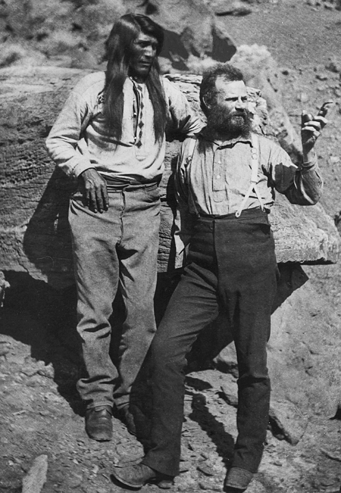
John Wesley Powell with Tau-gu
a Paiute, 1871-1872
Courtesy Arizona Historical Society

Upon return, surveyor Alven Thompson completed a topographic map of the region, and Powell’s monumental account was published in 1875 by the Smithsonian Institution.

The last “UNEXPLORED”s on the United States map were now replaced by specific landscape features with measured altitudes. Nowadays we still use the many evocative names that Powell and his men bestowed during their travels. Names like Flaming Gorge, Glen Canyon, Dirty Devil River, Escalante River, Cataract Canyon, and Desolation Canyon tell us something of the experiences of these brave men as they were exploring Utah’s last mysterious places.

Thanks to the Rocky Mountain Power Foundation for supporting research and development of this Wild About Utah topic.

Additional thanks to Rey Lloyd Hatt and the friendly staff of the John Wesley Powell River History Museum in Green River UT.

For Wild About Utah and Stokes Nature Center, I’m Holly Strand.
Credits:

Images: Copyright Dan Miller from the book
The River Knows Everything: Desolation Canyon and the Green

Powell images: Courtesy Arizona Historical Society

Text:     Holly Strand, Stokes Nature Center

Sources & Additional Reading

Aton, James M. and Dan Miller (photographer) 2009. The River Knows Everything: Desolation Canyon and the Green. Logan: Utah State University Press.

https://www.usu.edu/usupress/books/index.cfm?isbn=6523

Stegner, Wallace. “ Green River: The Gateway” in Blackstock, Alan. 2005. A Green River reader. Salt Lake City: University Utah Press.
https://www.amazon.com/Green-River-Reader-Alan-Blackstock/dp/0874808375

John Wesley Powell River History Museum in Green River UT https://johnwesleypowell.com/

USGS. 1976. Geological Survey Information 74-24. John Wesley Powell: Soldier, Explorer, Scientist.
https://www.nps.gov/history/history/online_books/geology/publications/inf/74-24/index.htm [Accessed October 30 2009]

A Grand Old River

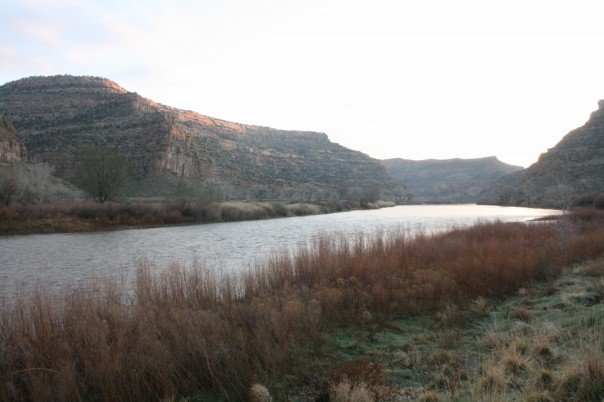
A Grand Old River: The Island Acres Part of James M. Robb Colorado River State Park Fruita, CO, Courtesy Daniel Smith, Photographer
The Island Acres Part of
James M. Robb Colorado River State Park
Fruita, CO
Courtesy Daniel Smith, Photographer
Hi, I’m Holly Strand of Stokes Nature Center in beautiful Logan Canyon.A Grand Old River

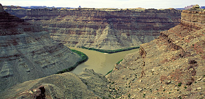
The Colorado River is the largest waterway in the southwest. 1,450 miles long, the Colorado River basin drains 248,000 square miles in 7 large states. In Utah, the river enters near Cisco south of I-70, winds its way through Arches and Canyonlands National Parks, then flows through Glen Canyon and exits south into Arizona.

Less than 100 years ago, the Colorado River wasn’t in Utah or even in Colorado. Until 1920, “Colorado River” referred only to the river section downstream from Glen and Grand Canyons. Upstream, it was called the Grand River all the way up the headwaters in the Colorado Rockies. Thus we have Grand County in Utah and the town of Grand Junction in Colorado.

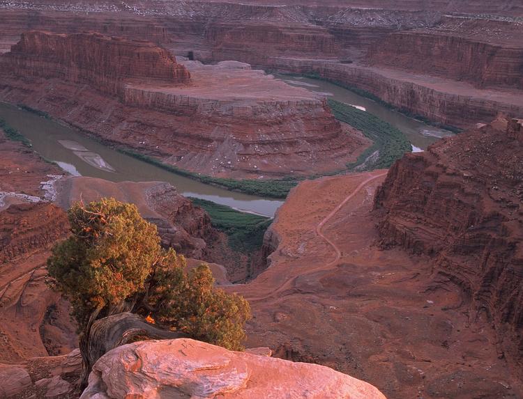
The Colorado River from
Dead Horse Point State Park,
near Moab,Utah, USA
Courtesy Phil Armitage, Photographer

According to Jack Schmidt, professor in Utah State University’s Department of Watershed Sciences and a longtime scholar of the river, the good citizens of the state of Colorado weren’t pleased with the Colorado River’s location.
So in 1920, the Colorado Legislature renamed Colorado’s portion of the Grand River, with a somewhat awkward result: The Colorado River began in Colorado, became the Grand River at the border with Utah and then became the Colorado River again at the confluence with the Green.

This arrangement did not last long –again because of a Colorado legislator. U.S. Representative Edward T. Taylor, petitioned the Congressional Committee on Interstate and Foreign Commerce to rename the entire river as the Colorado. Despite objections from Utah and Wyoming representatives and the U.S. Geological Survey, the name change was made official by the U.S. Congress on July 25, 1921.

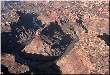
Confluence of the Colorado and Green Rivers
in Canyonlands National Park
Courtesy USGS
Photo by Marli Miller, Photographer

The objections were legitimate: In the 1890s the Federal Board on Geographic Names established the policy of naming rivers after their longest tributary. The former Grand River of Colorado and Utah was shorter than the Green River tributary by quite a bit. So the Green river should have prevailed and the Colorado should have been one of its tributaries.

However, if you judge tributary primacy by volume, the Colorado wins hands down. 100 years ago, the upper Colorado (or former Grand River) had a significantly higher total flow than the Green.

Confluence of the Colorado and Green Rivers
in Canyonlands National Park
Courtesy National Park Service

But what’s in a name? Prior to widespread European settlement, the Grand River was known as Rio Rafael and before that, different parts of the river had numerous Native American and Spanish names. A thousand years from now the rapidly evolving Colorado could have an entirely different identity. The main thing is that Utahns can enjoy and appreciate the habitat, scenery and many resources that this important waterway provides.

Thanks to the USU College of Natural Resources and the Rocky Mountain Power Foundation for supporting research and development of this Wild About Utah topic.

For Wild About Utah and Stokes Nature Center, I’m Holly Strand.

Map of the Colorado River Watershed by Karl Musser based on USGS data This file is licensed under the CCA ShareAlike 2.5 License.
Map of the Colorado River Watershed
by Karl Musser based on USGS data
This file is licensed under the
CCA ShareAlike 2.5 License.

Credits:

Images:

JamesMRobbColorado_riverDanielSmith.jpg: Taken in the Island Acres Part of James M. Robb Colorado River State park by Daniel Smith and released into the Public domain.

DeadHorsePtSP_UtahPhilArmitage.jpg: The Colorado River from Dead Horse Point State Park, near Moab, Utah, USA. Photo by Phil Armitage (May be used for any purpose)

ConfluenceUSGSMarliMiller.jpg: Confluence of the Colorado and Green Rivers in Canyonlands National Park. Courtesy USGS, Marli Miller, Photographer

ConfluenceNPS.jpg: Confluence of the Colorado and Green Rivers in Canyonlands National Park. National Park Service.

Colorado River Watershed Map, by Karl Musser based on USGS data, licensed under the
Creative Commons Attribution ShareAlike 2.5 License: In short: you are free to share and make derivative works of the file under the conditions that you appropriately attribute it, and that you distribute it only under a license identical to this one. Official license
Theme: Courtesy & Copyright Don Anderson as performed by Leaping Lulu https://www.leapinglulu.com/
Text: Mary-Ann Muffoletto, Holly Strand, Content reviewed by Jack Schmidt of Utah State University’s Department of Watershed Sciences and a longtime scholar of the Colorado River.
Voice: Holly Strand, Stokes Nature Center, https://logannature.org/

Additional Reading

The following references were accurate as of the date of publication or most recent update.

Many years ago, the Colorado River was just Grand, Summit Daily News, Frisco, CO, Dec 23, 2003, https://www.summitdaily.com/opinion/many-years-ago-the-colorado-river-was-just-grand/

Largest Rivers in the United States, J.C. Kammerer, USGS, Rev May 1990, https://pubs.usgs.gov/of/1987/ofr87-242/

Benke, A. C., and C. E. Cushing (editors). 2005. Rivers of North America. Academic/Elsevier. Amsterdam/Boston, 1168 pages.

Casey, Robert L. Journey to the High Southwest. Guilford, CT: Globe Pequot, 2007, p. 20.

Colorado Historical Society, Frontier Historical Society, https://web.archive.org/web/20080412093339/http://bioguide.congress.gov/biosearch/biosearch.asp

https://www.postindependent.com/article/20080325/VALLEYNEWS/68312863

”First Biennial Report of the Utah Conservation Commission, 1913,” Salt Lake City, Utah: The Arrow Press Tribune-Reporter Printing Co., 1913. p. 131.

McKinnon, Shaun. “River’s headwaters determined by politicians, not geography.” The Arizona Republic, 25 July 2004.

James, Ian, Scientists have long warned of a Colorado River crisis, The Los Angeles Times, July 15, 2022, https://www.latimes.com/california/story/2022-07-15/scientists-have-long-warned-of-a-colorado-river-crisis