The Bear River Range and River

Bear River Courtesy USDA Forest Service usda-forest_service_bear_river-250x188
Bear River
Courtesy USDA Forest Service
usda-forest_service_bear_river-250×188
Cache Valley Utah and the Bear River range that border its eastern edge are anomalies. Especially considering the abundance of water coursing through its canyons and valley bottom. Following a prolonged drought in the Salt Lake Valley in the 1850’s, it was the abundant wetland plants in cache valley’s center that first enticed Mormon pioneers to settle here. Fed by numerous streams discharging from the Bear River range and the mighty Bear River, these waters were trapped by the fine sediments of Lake Bonneville. The result was lush green forage, even in dry years. The native tribes and mountain men knew it well, and followed the wildlife which flourished here long before the arrival of pioneers.

I’ve quenched my thirst from the countless springs found in our eastern canyons and basins, always a reminder of our good fortune. One might ask, what set of circumstances allow Cache Valley to be so well watered? What follows are my hypotheses. A combination of geology, and climate.

The Bear River range, a subset of the Wasatch, is close to 20 miles wide, and averages well over 8,000 feet in elevation, topping just shy of 10,000 feet at Naomi Peak. Its height and width allow it to capture an abundant snowpack in normal years. The regional climate may be partially responsible as well. Extreme cold temperatures compared to surrounding mountains, the second coldest measured in the 48 states, atop Logan Canyon, enhance precipitation.

Geologically this mountain range is composed primarily of limestone and dolostone, both are excellent formations for absorbing water, which reappears as springs forming the headwaters of its numerous streams. As snow melts, water seeps through the broken limestone, referred to as Karst topography, until it hits an impervious layer of shale or mudstone, where it collects and eventually punches through a fractured seam of rock, to surface as a spring.

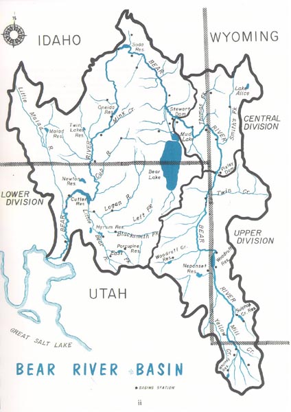
All are tributaries of the Bear River, plummeting from the north slope of the Uintah’s, a unique river system with its headwaters and mouth close to the same latitude. It provides nearly 2/3rds of the service water flowing into the Great Salt Lake. This is the longest river in North America which doesn’t end up in an ocean. With a changing climate proposed, further impoundment and diversions of these waters, the future of our unique hydrology is under constant threat. I wish us great wisdom in how we chose to manage this vital resource.

This Is Jack Green, and Yes, I’m wild about Utah.

Credits:

Pictures: Bear River Courtesy USDA Forest Service
Sound: Courtesy Kevin Colver
Text: Jack Greene, Bridgerland Audubon Society

Additional Reading:

Lopez, Tom, Bear River Range, IDAHO: A Climbing Guide, https://www.idahoaclimbingguide.com/bookupdates/bear-river-range/

Sempler, Ryhan, Menuz, Diane, Emerson, Richard, Mapping Wetlands in the Upper Bear River Watershed, Glad You Asked, Utah Geological Survey, https://geology.utah.gov/map-pub/survey-notes/mapping-wetlands-upper-bear-river/

Hylland, Rebecca, What are Igneous, Sedimentary & Metamorphic Rocks?, Glad You Asked, Utah Geological Survey, https://geology.utah.gov/map-pub/survey-notes/glad-you-asked/igneous-sedimentary-metamorphic-rocks/

The Bear River’s History and Contributions

The Bear River's History and Contributions: Bear River Basin Courtesy Utah Division of Water Rights bear.river_.basis_.waterrights.utah_.gov_.250x354.jpg
Bear River Basin
Courtesy Utah Division of Water Rights
bear.river_.basis_.waterrights.utah_.gov_.250×354.jpg
The Bear River meanders almost 500 miles from its headwaters in Utah’s Uinta Mountains to its mouth at the Great Salt Lake, making it the longest river in North America which does not empty into an ocean. Instead, the Bear River serves as the main source of fresh water for the Great Salt Lake, a vast terminal lake in the Great Basin with no outlet except evaporation. This hasn’t always been the case, though. The Bear River once flowed north, serving as a tributary of the Snake River, and ultimately reached the Pacific Ocean via the Columbia River. That is until about 140,000 years ago when the earth erupted in present-day southeast Idaho and spilled lava across the Bear River’s path.

The Bear River's History and Contributions: Canoeing on the Bear River, Cutler Reservoir Courtesy & Copyright Bryan Dixon, Photographer
Canoeing on the Bear River, Cutler Reservoir
Courtesy & Copyright Bryan Dixon, Photographer
Now obstructed by expansive lava fields hardening into immense walls of basalt rock, the Bear dog-legged to the south and became—for the first time—a source of fresh water for the ancient inland sea that would eventually become the Great Salt Lake. The river was tenacious, though, and spent its time not only feeding fresh water to ancestors of the Great Salt Lake but also chiseling away at the basalt columns that obstructed its way toward the sea. The river was finally rewarded for its efforts millennia after having been cut off from the Snake and Columbia River Basins, and once again became a tributary of the Snake River. This fate would not last, however. Roughly 35,000 years ago, violent geology would have its way again. More lava flows around present-day Soda Springs, Idaho, bent the Bear River back toward the Great Basin where it still empties today.

The Bear River's History and Contributions: the Bear River between Benson and Cutler reservoir in Cache Valley. Courtesy & Copyright Josh Boling, Photographer
the Bear River between Benson and Cutler reservoir in Cache Valley.
Courtesy & Copyright Josh Boling, Photographer
And this has been a boon for the millions of residents—Homo sapiens and otherwise—of the Wasatch Front here in Utah. Let’s consider for a moment what life in central and northern Utah would be like if not for the Bear River. For starters, the Great Salt Lake would lose 60% of its annual inflow, drastically reducing its volume. I wonder if Brigham Young and his Saints would have even considered settling in the Salt Lake Valley after enduring the many lake-bed-dust storms courtesy of the Great Salt Lake that are becoming a growing concern today. We would certainly be deprived of the world-class migratory bird and wetland habitat supported by the Bear River at the famous Bear River Migratory Bird Refuge. Last fall, Ogden’s Standard Examiner newspaper reported that, quote, “the river had disappeared into a vast mudflat that used to be Bear River Bay.” Experts cited irrigation, municipal, and habitat uses in addition to a host of environmental and climate factors as causes of the Bear River becoming “tapped out” before it reached the Great Salt Lake. A snowpack that has doubled last year’s total according to the Salt Lake Tribune has the Bear River Basin’s snowpack brimming at nearly 300% its average this time of year. This promises to turn things around for the Bear River and the many species which depend upon it.

A complex and interdependent collection of variables impact the Bear River and its hydrologic fate—not least of which are humans, ecology, climate, and the occasional volcanic eruption.

I’m Josh Boling, and I’m Wild About Utah!

Credits:
Images:
    Bear River Diagram Courtesy Utah Division of Water Rights
    Courtesy & Copyright Bryan Dixon
    Courtesy & Copyright Josh Boling
Sound:
Text: Josh Boling, 2019, Bridgerland Audubon Society

Sources & Additional Reading

Greene, Jack, The Bear River, Wild About Utah, May 24, 2018, https://wildaboututah.org/bear-river/

Beck, Russ, America’s Caveat River, Wild About Utah, Nov 16, 2016, https://wildaboututah.org/americas-caveat-river/

Hylland, Rebecca, What are Igneous, Sedimentary & Metamorphic Rocks?, Glad You Asked, Utah Geological Survey, https://geology.utah.gov/map-pub/survey-notes/glad-you-asked/igneous-sedimentary-metamorphic-rocks/