Airborne Snapping Grasshoppers

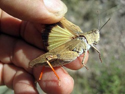
Snapping Grasshopper, Trimerotropis modesta, Courtesy & © David Bygott, Photographer
Snapping Grasshopper
Trimerotropis modesta
Courtesy & © 2010 https://bugguide.net/node/view/466693
David Bygott, Photographer

Utah has neither snapping turtles nor snapping shrimp, but we do have snapping grasshoppers. Their loud crackling sound punctuates summer hikes along open canyon slopes and rocky mountain ridges. (recording of a snapping grasshopper) Like other band-winged grasshoppers, they are named for the arcs of muted color across their hind wings.

But it is the male’s insistent racket that draws our attention. A snap results when a stout vein of their hind wings is flexed between two positions. That flexure alternately stretches and relaxes the membrane between the veins, something like an umbrella being popped open and then folded. The vein flexure generates an audible snap, like a dog’s training clicker. (recording of dog clicker) The grasshopper’s loopy flight generates a train of snaps. (recording of snapping grasshopper)

Crepitating cicadas have a similar means of sound production. They click from a perch on a plant stem. (recording of cicada) Their clicking has filled the air of northern Utah this summer.

As with cicadas, it is the male band-winged grasshopper that snaps to woo a mate. He displays solitarily during flight, the longer advertisement the better, apparently. Hopefully, an attracted female will meet him in the air. Sadly for the male, most of the time no female responds and he lands unrequited. There the previously conspicuous male seems to silently vanish, so perfectly does his mottled tan camouflage match bare ground. After resting a bit, he launches again to resume his crackling display.

Species of band-winged grasshopper differ in their snapping displays, which a female no doubt appreciates. But for you and I, it is enough to know that we are hearing snapping grasshoppers on a warm day’s hike.

Credits:
Images: Courtesy © 2010 David Bygott, Photographer, bugguide.net
Audio: Jim Cane, Bridgerland Audubon Society
Text: Jim Cane, Bridgerland Audubon Society

Additional Reading:

Otte, Daniel. 1970. A Comparative Study of Communicative Behavior in Grasshoppers.

Miscellaneous Publications Museum of Zoology, University Of Michigan, No. 141 https://deepblue.lib.umich.edu/bitstream/handle/2027.42/56385/MP141.pdf?sequence=1
Cloud classification

Cloud classification: Wispy high-flying cirrus clouds made of ice crystals. Courtesy & © Jim Cane, Photographer
Wispy high-flying cirrus clouds
made of ice crystals.

Courtesy & © Jim Cane, Photographer
 
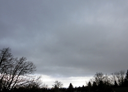
Cloud classification: A dark monotonous low deck of stratus clouds. Courtesy and Copyright Jim Cane, PhotographerA dark monotonous low deck
of stratus clouds.
Courtesy & © Jim Cane, Photographer
 
Cloud classification: Fair-weather cumulus clouds with flat bottoms and puffy tops.Fair-weather cumulus clouds
with flat bottoms and puffy tops.
Courtesy & © Jim Cane, Photographer
 
Fair-weather cumulus clouds with flat bottoms and puffy tops.Fair-weather cumulus clouds
with flat bottoms and puffy tops.
Courtesy & © Jim Cane, Photographer

 
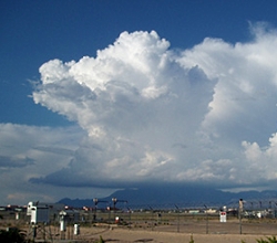
A dense cloud that grows upward, looks like a cauliflower, anvil, or tower, and usually has lightning, thunder, and rain.Cumulonimbus
A dense cloud that grows upward, looks like a cauliflower, anvil, or tower, and usually has lightning, thunder, and rain.
Courtesy NOAA


Who has not indulged in the idle pastime of watching puffy white clouds pass overhead, naming their shapes as they form? Of course, such whimsical names do not serve comparative description and understanding. For this, a lexicon of clouds is needed. Our formal cloud classification system traces back to 1803, when an Englishman, Luke Howard, published “An essay on the modifications of clouds”. Luke Howard owned a profitable pharmaceutical company, which funded his gentlemanly meteorological pursuits. Mr. Howard wisely chose a Latin cloud vocabulary to name and illustrate three fundamental cloud types.

The highest flying clouds he named cirrus, meaning curl or tuft, as of hair. These wispy clouds often resemble fibers; one form is the aptly named horse-tail cirrus. Composed of ice crystals, cirrus clouds form at around 30,000 feet, about the cruising altitude of passenger jets. Wispy cirrus clouds often portend a stormy Pacific low-pressure system en route to Utah.

Howard dubbed a type of lower elevation cloud cumulus, meaning mass or heap. These grow from mere puffs to big flat-bottomed clouds with white cauliflower tops. For sheer meteorological beauty, nothing beats legions of fair weather cumulus scudding across a bluebird sky atop a montane backdrop.

The lowest cloud form is stratus. Forming below 8000 feet, they appear as an extensive deck of unbroken gray. Stratus clouds often bring Utah’s winter snowstorms and spring rains. Nimbostratus are responsible for Seattle and Portland’s endless winter drizzle. In contrast, our Utah summer rains fall from towering cumulonimbus thunder heads. These ominous clouds are powered by hot summer updrafts and the steamy humidity that flows northward with the North American monsoon.

Luke Howard’s cloud-naming convention includes 10 principal types in all which easily lend themselves to naming combinations. You can now envision the height and appearance of cirrocumulus clouds, for instance. Cirrus, cumulus, stratus, nimbus, the cloud lexicon of amateur meteorologist Luke Howard has endured for over 200 years. Pictures of these cloud types with a link to the pages of Howard’s original published treatise can be found at our Wild About Utah website.

This is Linda Kervin for Bridgerland Audubon Society.

Credits:
Images: Courtesy NOAA and
             Courtesy & Copyright Jim Cane
Text: Jim Cane

Additional Reading:

Luke Howard. 1803. “Essay on the modifications of clouds by “3rd ed. Published 1865 by John Churchill & Sons in London .
https://archive.org/details/essayonmodifica00howagoog and
https://books.google.com/books?id=7BbPAAAAMAAJ&printsec=frontcover#v=onepage&q&f=false

Riehl, Herbert. 1978. “Introduction to the Atmosphere.” McGraw-Hill, NY.
https://www.amazon.com/Introduction-Atmosphere-Herbert-Riehl/dp/0070526567

International Cloud Atlas, World Meteorological Organization,https://cloudatlas.wmo.int/home.html

Those Howling East Winds

Those Howling East Winds: Normal Diurnal Wind Shift Along the Wasatch Front, Courtesy Utah Division of Air Quality
Normal Diurnal Wind Shift
Along the Wasatch Front
Courtesy Utah Division of Air Quality

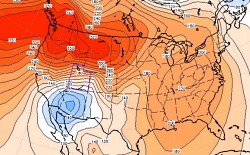
Those Howling East Winds: Air Pressure at the Surface, A Bit of a Blow..., Utah Climate Notes, January 2012, Courtesy Utah Climate Center, Utah State University Air Pressure at the Surface, 1 Dec 2011
Blue=Low Pressure, Red=High Pressure
The spacing of the lines is a measure of the pressure gradient: the closer the lines, the higher the pressure gradient. https://climate.usurf.usu.edu/news/010512Utah%20Climate%20Update%20(Jan%2012).pdf[Feb 6, 2014]
Read: A Bit of a Blow…
Courtesy Utah Climate Center, Utah State University

Wind is inevitable on a spinning planet with an atmosphere and a sun. At our latitude, westerlies prevail, but east winds do occur now and then. Locally, canyons daily exhale denser, cooler mountain air that drains into valleys. In Logan, trees blown by these canyon winds tilt westward. Occasionally, though, the whole Wasatch front is whipped by howling gales from the east, leaving behind shredded shingles, snapped tree limbs and rolled tractor-trailers. These forceful east wind events have a regional weather origin that is intensified by local topography.

It begins with a strong high-pressure cell parked over southwestern Wyoming.  It’s descending dry air circulates clockwise. Somewhere to the south or southwest, a low-pressure cell is needed.  The strong air pressure gradient between high and low generates a wind that races westward from Wyoming. The surging wind pours over the entire Wasatch front like water over a flat boulder in rapids.  These winds then plunge down slope, blowing quickest where the descent is long, steep, and unobstructed. The down rushing air slams onto the flat benches and valley floors.  In November 2011, such winds ripped Centerville with 100 MPH gusts.

Where these so-called mountain wave events blow regularly they often have names.  The mistral and foehn winds howl down from the Alps, chinooks  race down the Rocky Mountain Front Range, and the Santa Anas blast Southern California. The steep altitudinal descent of these parched winds compressively heats the air. A spark or flame soon transforms to a raging wildfire when fanned by a drying foehn or Santa Ana wind.  Europe’s foehns are also known to spark short tempers and stress.

Perhaps the sporadic easterly gales that lash the Wasatch Front and Cache Valley deserve an evocative name too.  For now, you at least know the answer to what’s blowin’ in the east wind.

Thanks to Martin Schroeder at the Utah Climate Center for insights and the stream boulder analogy

This is Linda Kervin for Bridgerland Audubon Society.

Credits:
Diurnal Utah Winds Image: Courtesy Utah Division of Air Quality
Surface Air Pressure 1 Dec 2011 Image: Courtesy Utah Climate Center, USU
Text: Jim Cane

Additional Reading:

Martin Price, Alton Byers, Donald Friend, Thomas Kohler, Larry W. Price. 2013. Mountain Geography: Physical and Human Dimensions. Univ of California Press. pages 71­74. https://www.amazon.com/Mountain-Geography-Physical-Human-Dimensions/dp/0520254317

Mesmerizing live wind map of US at:  https://hint.fm/wind/

Forecast of damaging east winds along the Wasatch Front, end of November 2011, https://www.ksl.com/?sid=18282965

How Chinooks Occur, Wikipedia, https://en.wikipedia.org/wiki/Chinook_wind#How_Chinooks_occur

Defining the Great Basin

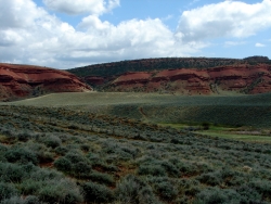
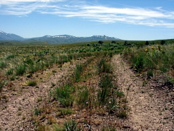
Willow Creek North of Wells, NV. Sagebrush at mid-distance. Route of the California Trail used by pioneers.
Willow Creek north of Wells, NV.
Sagebrush at mid-distance.
Route of the California Trail
used by pioneers.

Courtesy & Copyright
Jim Cane, Photographer

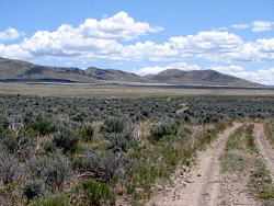
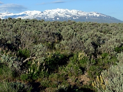
Lupines amid sagebrush north of Wells, NV. Ruby Mountains in backgroundLupines amid sagebrush
north of Wells, NV.
Ruby Mountains in background
Courtesy & Copyright
Jim Cane, Photographer

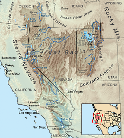
Map delineating the Great basinMap delineating the Great basin
Courtesy Wikimedia, KMusser, Artist
Ref: wikipedia.org/wiki/Great_Basin


The Great Basin is aptly named.  Twice the size of Kansas, it stretches from the watersheds of the Columbia and Snake rivers south to that of the Colorado, and from the crests of the Sierra Nevada and southern Cascades eastward to the Wasatch front.  The Western explorer John Fremont coined its name in 1845.  The rivers and streams of the region that Fremont had seen all ended in sinks, marshes or lakes. None flowed to the Pacific Ocean.  He confirmed this on meeting Joseph Walker at Mountain Meadows in Utah.  Walker had traveled more of the basin’s western margins, dispelling  rumors of a river traversing the Sierra Nevada.  Precipitation that falls in the Great Basin stays in the Great Basin; water leaves only as vapor.  This is the hydrographic Great Basin.

How else to view the vast region between the Rockies and the Sierra Nevada? Geologists speak of the “Basin and Range Province”, so named for its valleys and the towering ranks of north-south mountain ranges that march across the landscapes of Nevada and edges of adjacent states. Unlike the upthrust Rockies and Sierra Nevada, Earth’s crust in the Great Basin appears to be spreading, to be pulling apart. The tilted escarpments of the Wasatch front are the easternmost evidence of this crustal deformation that has built the Basin and Range Province.

Botanists delimit the Great Basin by the hardy flora that clothes this rugged landscape. Great Basin plants tolerate freezing winters and parched summers, and in the valleys, soils of varying salinity.  The so-called Sagebrush Ocean fills many of the basins, as do other shrubs, such as shadscale and greasewood.  Upslope, these give way to juniper woodlands, often mixed with piñon pine.  This floristic Great Basin reaches eastward to central Utah and the Wasatch front, beyond which trees and other plants of the Rockies make their appearance.

The boundaries of all three concepts for the Great Basin — hydrographic, geologic and floristic — largely coincide.  Each recognizes the distinctive attributes of the Great Basin that set it apart from neighboring regions.  The Great Basin is readily recognizable to the trained eye, whether looking at satellite images, river courses, or the native plant communities encountered on a simple walk.

Credits:
Images: Jim Cane
Map: Courtesy Wikimedia, KMusser, Artist, licensed under Creative Commons Attribution-Share Alike 3.0 Unported
Text: Jim Cane

Additional Reading

Frémont, John Charles. 1845. Report of the exploring expedition to the Rocky Mountains in the year 1842 and to Oregon and North California in the years 1843 – 44. Printed by order of the Senate of the United States , Gales & Seaton, 693 pages. –available as a Google eBook scanned from the original published book Grayson, Donald K. 1999. The desert’s past : a natural prehistory of the Great Basin. Smithsonian Institution Press, Washington D.C., 356 pages. –an exceptionally readable, thorough and authoritative overview of the Great Basin, with many maps, photographs and illustrations.https://books.google.com/books?id=W8ICAAAAMAAJ

Intermountain Regional Herbarium Network. searchable plant database representing multiple holdings of herbaria at universities in Utah and Nevada, with maps, images and more https://swbiodiversity.org/seinet/projects/index.php?proj=10

McPhee, John. 1981. Basin and Range. Farrar, Straus, Giroux, New York. 215 pages. –the first of the author’s many engaging books about geology. https://www.amazon.com/Basin-Range-John-McPhee/dp/0374516901