Public Lands – good or bad?

Click to view Coyote Pups on the public lands of the Malheur National Wildlife Refuge, Courtesy US FWS

Coyote Pups
on the Malheur National Wildlife Refuge

Courtesy US FWS 

This morning I spent some time skiing up Smithfield Canyon in the Uintah Wasatch Cache National Forest. Growing up in Michigan where public land was hard to come by, I have come to enjoy our “commons” where I’m not trespassing on posted private land, or required to pay a fee before entering.

With the Oregon Bundy-Hammond event taking center stage, it has forced me to do some reflecting on what is right and what is wrong regarding our public lands.

To begin with, I’m biased in two ways- both for the land and for the ranching culture- I have deep affection for both. In my 11 seasons as a Wilderness Ranger for the Logan Ranger District of the USFS and 6 seasons with the National Park Service, I have become well aware of how our public lands are managed- the good, bad, and the ugly. On our national forest the primary issue I was confronted with was livestock grazing. The damage done by cattle and sheep was significant, plus predator control seriously interfered with how natural systems operate in balancing herbivores with their forage supply. Health of the land was always of paramount concern, but due to forest managers having very limited resources, best practices for maintaining healthy ecosystems and watersheds was compromised.

Regarding the livestock industry, it excites me to see real cowboys on horseback rounding up their animals- the romance of the west. I would love to join them. Conflicting with these feelings is my relief that the land will begin to heal from damage that often occurs when utilizing sensitive areas unsuitable for these animals, especially in large, concentrated numbers. And as a back country recreationist, I prefer elk, moose, and mountain sheep, to domestic stock and the artificiality they represent.

There are many examples of ranchers that manage their livestock well, and place them where little damage occurs. There are even ranchers who are willing to sacrifice some of their animals who realize the value of large predators in maintaining healthy ecosystems.

Do I support the Bundy takeover, or the Hammonds who violated the Bureau of Land Management laws in numerous instances? A resounding “NO!” in both cases. But I do wish them well in finding a way to maintain their ranching operations- perhaps by adding eco and/or cultural tourism or renewable energy options to provide additional income. Recreation and tourism has become our largest industry, contributing billions to the economy. More recently, renewable energy has manifested astronomical growth in the forms of geothermal, wind, and solar. Further, well managed rangelands can help remove, or sequester, carbon dioxide from the atmosphere- another potential market.

In the end, I wish both well- restoring health and access to our public lands; and preserving a flourishing ranching culture.

This is Jack Greene for Wild About Utah.

Credits:
Image: Courtesy US FWS
Text:     Jack Greene, Bridgerland Audubon Society


Additional Reading:

Kaste, Martin, NPR Around the Nation, Armed Protesters Occupy Malheur National Wildlife Refuge Center In Oregon, https://www.npr.org/2016/01/04/461944981/armed-protesters-occupy-malheur-national-wildlife-refuge-center-in-oregon

Siegler, Kirk, NPR America, Who Will Blink First? Armed Occupation In Oregon Drags On, https://www.npr.org/sections/thetwo-way/2016/01/12/462813360/who-will-blink-first-armed-occupation-in-oregon-drags-on
Utah’s Petroglyph Garden

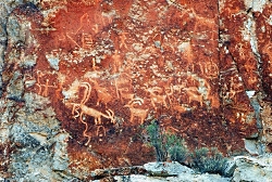
Click to view Petroglyph Panel at the Fremont Indian State Park & Museum, Photo Courtesy Sevier County, Kreig Rasmussen, Photographer
Petroglyph Panel at Fremont Indian State Park & Museum
Photo Courtesy Sevier County
Kreig Rasmussen, Photographer

Hi, I’m Ru Mahoney with Stokes Nature Center in Logan Canyon.

Utah’s culture is rich with vestiges of our pioneer history, and the landscape is accented by visible signs of the European settlers who forged our modern communities. But the tapestry of Utah’s cultural heritage is interwoven with much older threads, as indelible and enduring as the landscape itself.

In the 1980’s, in the southwestern quadrant of central Utah, the construction of interstate 70 unearthed a secret over one thousand years old. The valleys and canyons of what is now Sevier County, already known as a seasonal thoroughfare for the Paiute, had an even older history as home to the largest community of Fremont Indians ever discovered. Influenced by their Anasazi cousins to the southwest, the Fremont culture encompassed a diverse group of tribes that inhabited the western Colorado Plateau and the Great Basin area from roughly 400 to 1350 A.D. Archaeologists tell us they were a people of ingenuity in their engineering, aggression in their social interactions, and lasting creativity in their artistic expression. Divergent theories on their fate suggest they drove the Anasazi out of the Four Corners region and eventually migrated to further landscapes, or that northern groups of Fremont peoples joined with bands of Shoshone and became the Ute Indians of the Uinta. Whatever the truth of their ultimate fate may be, nowhere is their history more tangible than at Fremont Indian State Park just south of Sevier, UT along I-70. This year-round state park offers visitors a treasure trove of artifacts and curated exhibits in an excellent visitor’s center. But the most authentic interaction with these past peoples comes from exploring the surrounding landscape.

Driving the winding road into Clear Creek Canyon, ghostly figures begin to emerge; pictographs painted in shades of ocher and umber, and pale petroglyphs carved into the canyon walls, reveal an archaic and epic account of Utah’s ancestral past. A unique creation story, in which a shrike leads the Fremont people from a dark and cold underworld through the stem of reed into the warm world above, plays out across the canyon walls. A craggy outcrop of rock in the shape of an eagle is said to be watching over the reed to the underworld below to insure nothing wicked escapes into our world. A concentric lunar calendar and an abundance of zoomorphics speak of a cultural identity conceived in relation to the broader astrological world, and a reverence for anthropomorphized neighbors such as bighorn sheep and elk. Spider Woman Rock juxtaposes a powerful figure of Native American mythology with the pedestrian humility of a nursing mother. And Cave of 100 Hands is a visceral exhibition of a humanity simultaneously reminiscent and divergent from our own.

While the Fremont culture is believed to have died out or been absorbed by other modern groups, Clear Creek Canyon and the rock art sites of Fremont Indian State Park are significant among the modern Kanosh and Koosharem Bands of the Paiute who began using the area and leaving their own indelible marks on the canyon walls after the disappearance of the Fremont peoples around 1400 A.D. On the vernal and autumnal equinox (occurring in the third or fourth week of March and September each year) the eagle rock casts its shadow over the reed rock at dawn, breathing life into ancient tales of our ancestral history.

Fremont Indian State Park is a notable destination for those interested in rock art sites, many of which are suited to families of all ages and mobility, including visitors with strollers and wheelchairs. Stop in the visitor’s center to borrow or purchase a guide to the petroglyphs and pictographs for deeper insight into the Fremont culture and an unforgettable glimpse into Utah’s past.

For Wild About Utah and Stokes Nature Center, I’m Ru Mahoney.

Credits:
Images: Courtesy Sevier County, Kreig Rasmussen, Photographer
Text:     Ru Mahoney, Stokes Nature Center in Logan Canyon.


Additional Reading:

https://stateparks.utah.gov/parks/fremont-indian/

https://stateparks.utah.gov/stateparks/wp-content/uploads/sites/26/2015/02/Fremont_IndianBrochure.pdf

https://www.nps.gov/grba/learn/historyculture/fremont-indians.htm

https://www.thefurtrapper.com/fremont_indians.htm

Take the Pledge to Protect the Past, Utah State Historical Preservation Office, Department of Cultural & Community Engagement, State of Utah, https://ushpo.utah.gov/shpo/upan/

Christmas Bird Count (CBC) and Climate Change

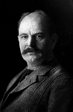
Click for a larger view of Frank M. Chapman, organizer of the first christmas bird count, Courtesy Wikimedia, Image in the public domain
Frank M. Chapman
Courtesy Wikimedia
Image in the public domain
 

On December 19th, I will have joined several others for an exciting day of counting bird species and numbers in our lovely, snowy valley. Our numbers will be entered on a database that will be shared with the world. The Christmas Bird Count began on Christmas Day in the year 1900 when ornithologist Frank M. Chapman, an officer in the nascent Audubon Society, proposed a new holiday tradition—a “Christmas Bird Census” that would count birds during the holidays rather than slaughtering them, which had been the past ritual.

The data collected by observers over the past 115 years has allowed researchers to study the long-term health and status of bird populations across North America. When combined with other surveys such as the Breeding Bird Survey, it provides a picture of how the continent’s bird populations have changed in time and space. This long term perspective is vital for conservationists. It informs strategies to protect birds and their habitat, and helps identify environmental issues with implications for people as well.

Along with the fun it brings, this year’s count will have special significance for our local Audubon chapter which was awarded a National Audubon grant for “spreading the word” on our changing climate’s impact on birds. Through the grant writing and implementation I have a heightened awareness of how bird populations and their spacial distribution are changing at an accelerating rate.

Audubon’s 2014 Climate Change Report is a comprehensive, first-of-its kind study that predicts how climate change could affect the ranges of 588 North American birds. Of the bird species studied, more than half are likely to be in trouble. The models indicate that 314 species will lose more than 50 percent of their current climatic range by 2080.

The Environmental Protection Agency (EPA) has included Audubon’s climate change work from CBC data as one of 26 indicators of climate change in their 2012 report.

In 2007, CBC data were instrumental in the development of Audubon’s Common Birds in Decline Report, which revealed that some of America’s most beloved and familiar birds have taken a nosedive over the past forty years.

142 species of concern are found in Utah including our state bird, the California gull and our the bald eagle, our national bird. Averaging the most recent 10 years, our valley has seen 16 species increase and 11 species decline. Of course we would need a take a much broader sweep to know the true story of these species, but our data may play a significant part in the overall analysis.
And please keep those bird feeders full as we enter the coldest month of the year!

This is Jack Greene for Wild About Utah.

Credits:
Image: Courtesy Wikimedia and in the public domain
Text:     Jack Greene, Bridgerland Audubon Society


Additional Reading:

An Arizona Road Trip Back Into the Past

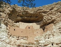
Montezuma Castle, Courtesy US NPS
Montezuma Castle
Courtesy US NPS
 
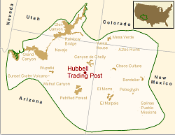
Location of Hubbell Trading Post NHS in the Southern Colorado Plateau Network,  Courtesy US NPSLocation of Hubbell Trading Post NHS in the Southern Colorado Plateau Network
https://science.nature.nps.gov/im/units/scpn/parks/hutr.cfm/[Nov 2, 2015]
Courtesy US NPS
 
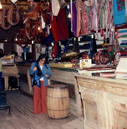
Hubbell Trading Post, Courtesy US NPSHubbell Trading Post Interior
Courtesy US NPS

Arizona is rich in history — from the 1800s all the way back to the Late Triassic Period. You can stitch together a road trip that winds out of Flagstaff to Montezuma Castle National Monument, to Petrified Forest National Park, and ends at Hubbell Trading Post National Historic Site. Along the way you’ll experience fascinating chapters of geologic and cultural history.

At Montezuma Castle, 45 minutes south of Flagstaff and just off Interstate 17 (Exit 289), a short walk places you in front of a 5-story-tall cliff dwelling that offered safety from invaders: it stands 100 feet above the valley floor, nestled into an alcove.

The site was misnamed Montezuma Castle in the late 1800s by whites who thought the structure had been built by the Aztec people. The original owners, members of the Southern Sinagua (seen aug wah) people, called this area home from roughly 1100-1425 A.D.

Stroll the short trail that loops around a vegetated landscape below the “castle,” and you’ll find great views as well of the remains of Castle A. That dwelling once rose 60 feet and was home to about 100 residents.

From Montezuma’s Castle, it’s 95 miles via Arizona 87 to Winslow, and then 34 miles east on Interstate 40 to Holbrook. Finally, another 19 miles southeast on Arizona 180 leads you into Petrified Forest National Park and its unusual landscape.

There’s no lodging within the park, and you have to leave by sundown, so you will need to make some tough decisions if you have just one day. Do you take time to tour the Rainbow Forest Museum with its dinosaur displays, or hike out to Agate House?

A building built of petrified wood is pretty cool, so stretch your legs with a walk to the house. Then head north and deeper into the park to the Crystal Forest Trail. Wander this path and you’ll find yourself surrounded by petrified wood with its hues of yellow, red, and green, black and white.

Blue Mesa is another great stop. There’s a trail that takes you down into another colorful landscape of badlands and chunks, logs, and even slabs of petrified wood in shades of red, blue, yellow and black.

The northern end of the park road is anchored by the Painted Desert, a great place for sunset photos. Here you’ll also see the Painted Desert Inn, which some day could put the Park Service back into the lodging business but today is just a museum piece.

Back on Interstate 40, drive 22 miles east to Chambers, and then north on U.S. 191 for about 38 miles to Ganado and Hubbell Trading Post. This authentic trading post was opened by John Lorenzo Hubbell in 1878 on the Navajo Reservation.

Although it was added to the National Park System in 1967, Hubbell is not a museum piece but an active trading post. As such, it still holds richly woven Navajo rugs, jewelry, and other Native American artworks for purchase.

Schedule your visit to Hubbell Trading Post for May and you just might be able to attend the annual Native American Art Auction. Check with the park (928-755-3475) for the exact date.

If you have a little more free time, you could extend your your trip by heading 39 miles north on 191 to Canyon de Chelly National Monument.

For Wild About Utah and National Parks Traveler, I’m Kurt Repanshek.

Credits:
Image: Courtesy and Copyright Kurt Repanshek, www.nationalparkstraveler.com
Text:     Kurt Repanshek, NationalParksTraveler.com.


Additional Reading:

Montezuma Castle National Monument, NationalParksTraveler.com, https://www.nationalparkstraveler.com/2012/03/visiting-montezuma-castle-national-monument-arizona9636

Montezuma Castle National Monument, US National Park Service, https://www.nps.gov/moca/index.htm

Geographic Area covered by the State of Deseret and Utah Territory, International Society Daughters of Utah Pioneers, https://www.dupinternational.org/dyn_page.php?pageID=54