
, Hagerman Fossil Beds National Monument, Courtesy US NPS")
 Elmer Cook Recognition Plaque
Hagerman Fossil Bed National Monument
Courtesy & © Mary Heers, Photographer
 Mary Heers’ Selfie with the Hagerman Horse
Hagerman Fossil Bed National Monument
Courtesy & © Mary Heers, Photographer
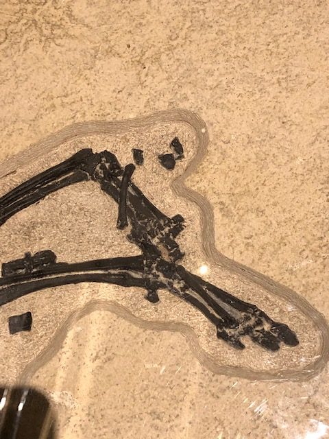 Three Toes on the Kemmerer Horse
Utah Museum of Natural History
Courtesy & © Mary Heers, Photographer
 Metacarpal Toe, Hoof Hagerman Horse
Equus simplicidens
Hagerman Fossil Bed National Monument
Courtesy & © Mary Heers, Photographer
 Metacarpal Toe, Hoof Domestic Horse
Equus ferus caballus
Hagerman Fossil Bed National Monument
Courtesy & © Mary Heers, Photographer
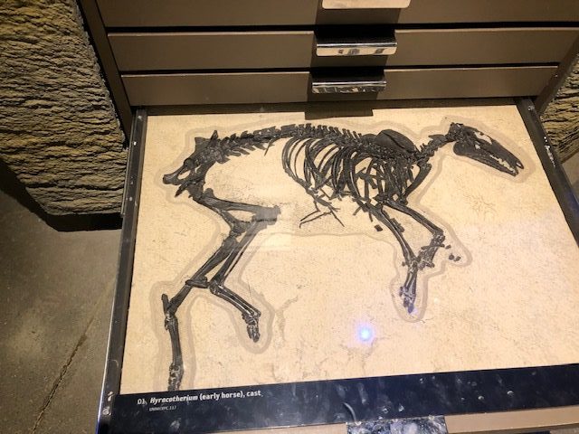 Cast of Kemmerer Early Horse
Utah Museum of Natural History
Courtesy & © Mary Heers, PhotographerIn 1928 Elmer Cook, a rancher in Hagerman, Idaho, noticed an interesting bone sticking our of the hillside on his land overlooking the Snake River. Intrigued, he started to dig around and discovered it was a fossilized bone and there were plenty more like it. Elmer alerted the National Smithsonian Museum, who sent out a team. This team determined the bones were ancestors of the modern horse. They were 3½ million years old. In the end, after digging into the hillside for 2 years, they took over 200 fossils, including 12 complete horse skeletons, back to Washington D.C.
My own fascination with horse fossils actually began a few years ago when I was giving tours at the Utah Museum of Natural History in Salt Lake City. A fossil hunter near Kemmerer, Wyoming, had been quite surprised to find a small mammal while digging through layers of fossilized fish in an ancient seabed. This skeleton is now also in the Smithsonian Museum in D.C., but the Utah museum owns a copy.
When giving tours, I always paused my group as we entered the dinosaur floor. “I’m going to pull a whole horse out of here,” I’d say as I pulled a sliding drawer out of a chest with a flourish.
It was a fully grown horse about the size of a small dog – 24 inches long and 20 inches high.
It was over 50 million years old. In that time, the Intermountain West was a lush, swampy place. Fierce predators like the Utah Raptor roamed the land, and the mammals that survived were small and stayed hidden in the dense forested undergrowth.
Over the next 50 million years, the dinosaurs went extinct and the terrain dried out The Hagerman Horse (dating back 3 ½ million years ) stood about 4 ½ feet high. Most notably, it now stood on four hooves. The 3 toes on the Kemmerer Horse had evolved into a single dominant toe, perfectly adapted to running away from predators over dry terrain.
Unfortunately, this remarkable adaptation was not enough to save the horse. The horse went extinct in the Americas (along with other large mammals like the mammoth and giant sloth) about 10,000 years ago. It was the Spanish Conquistadors that reintroduced the horse to North America. When Hernan Cortez and his 200 soldiers landed in Mexico in 1519, they brought 16 horses with them. Over time, some of these horses got away to form wild bands, and others fell into the hands of the Native Americans.
This summer I made a small archeological pilgrimage into Idaho, to see the Hagerman Fossil Beds, now a National Monument. In the newly opened visitor center I found a life size replica of the Hagerman Horse. As I stood next to it, admiring its shapely hoof, I remembered one more remarkable fact about the horse. The bows now used to play violins are made from horse hair It takes 5 horse tails to make a violin bow. To this day, absolutely nothing has been found that makes the strings of a violin sing as sweetly.
This is Mary Heers and I am Wild About Utah.
Credits:
Photos: Courtesy & Copyright © Mary Heers
Photos: Courtesy
Featured Audio: Courtesy & Copyright © Kevin Colver, https://wildstore.wildsanctuary.com/collections/special-collections/kevin-colver
Text: Mary Heers, https://cca.usu.edu/files/awards/art-and-mary-heers-citation.pdf
Additional Reading: Lyle Bingham, https://bridgerlandaudubon.org/
Additional Reading
Wild About Utah, Mary Heers’ Wild About Utah Postings
Hagerman Fossil Beds National Monument, History, National Parks Service, US Department of the Interior, https://npshistory.com/publications/hafo/index.htm
The Hagerman Horse (Equus simplicidens), Hagerman Fossil Beds National Monument, National Parks Service, US Department of the Interior, https://www.nps.gov/articles/000/equus_simplicidens.htm
Hagerman Fossil Beds, National Parks Service, US Department of the Interior, https://www.nps.gov/hafo/index.htm
The Horse (Exhibit), Natural History Museum of Utah, July 21, 2014 – January 4, 2015, https://nhmu.utah.edu/horse#:~:text=The%20Natural%20History%20Museum%20of,and%20spiritual%20connections%20with%20them.
Natural History Museum of Utah,https://nhmu.utah.edu/
Fossil Horse Quarry Near Hagerman, Idaho, Worked by National Museum, Smithsonian Libraries and Archives, The Smithsonian Institution, https://www.si.edu/object/fossil-horse-quarry-near-hagerman-idaho-worked-national-museum:siris_arc_367758
Plesippus shoshonensis Gidley, 1930, National Museum of Natural History, The Smithsonian Institution, https://www.si.edu/object/plesippus-shoshonensis-gidley-1930:nmnhpaleobiology_3590445


