Logan City Mayor Holly Daines said, “The Logan River Task Force has been really helpful to the city in working on river restoration! Quality of life is such an important part of our community. By expanding trails, and restoring the river wherever possible, we’re [creating] great places where we can enjoy [a] little slice of nature.”
The Stewart Park Project demonstrated that, instead of building walls, if the owner allows occasion flooding onto lower “terraced” areas which are planted with native vegetation, it allows the river to grow a little wider and this, along with the friction from the vegetation, slows the flow and dissipates the energy of the flood through the entire [river] system.
This approach of balancing social and ecological values in river restoration used by the Logan River Task Force can be applied to rivers throughout Utah.
Children enjoying Logan River as they search for insects among the dropped sediments of the Logan River. Courtesy & Copyright Shauna Leavitt, PhotographerLogan River’s geomorphology, or landform, has changed very little over the past 150 years in the mountain canyons. But where the river leaves the mountains and drops down onto Cache Valley’s floor, its geomorphology has changed dramatically.
A river’s geomorphology is how it interacts with its environment, how it changes and moves over time, how it picks up sediment and debris when its flowing fast then releases the sediments downstream where the river slows and spreads over open-flat landscapes.
Father and son enjoying a day of fishing on the reservoir behind First dam in the mouth of Logan Canyon Courtesy & Copyright Shauna Leavitt, PhotographerThe route of Logan River is noteworthy. Peter Wilcock, department head of Watershed Sciences in the Quinney College of Natural Resources explains, Logan River cuts through a large amount of the Bear River mountain range [in northeastern Utah and southeastern Idaho] and is by far the biggest drainage from the range.
The river’s size has made a mark on the mountain. When all the tributaries and springs come together, the result is the fast-flowing river with great force for erosion. If you compare Logan Canyon with other canyons coming out of the Bear River Range such as Green Canyon or Providence Canyon you can see Logan Canyon is close to 600 feet lower than all the other canyons. The volume and force of Logan River cut through the beach material that ancient Lake Bonneville left behind, the other drainages have been too small to cut through the ancient short line.
In the early 1800s, the lower part of Logan River flowed freely, meandering and spreading across the Cache Valley floor. As it entered the valley, the river would form into an alluvial fan spreading like fingers over the valley floor and meeting the natural functions of a river to transport water, sediments and nutrients.
As each decade passed an increasing number of buildings, roads and complex infrastructures were built to keep up with the growing population. And to protect this infrastructure, people attempted to restrict the movements of the river. In many places, the river was straightened or channelized even as its water was re-routed for irrigation.
The dams placed along the river and at the mouth of Logan Canyon slowed the river before it reached the valley floor. As a result, a large percentage of the sediments which would have dropped on the valley floor, are now captured behind the river’s dams and fill the reservoirs.
Frank Howe, chairman of the Logan River Task Force, explains how this impacts the river’s geomorphology, “Water released from the dams is free of deposits; the river is now “hungry” – hungry for new sediments. It’s now capable of picking up large amounts of sediments which causes erosion problems miles below the dams.”
The Logan River Task Force, consisting of representatives from Utah State University, Logan City, Cache County, State and Federal Agencies, six non-profit organizations, corporations and interested citizens came together to find solutions to the erosion problem and other river issues. To address these issues, they prepared a “long-term plan for the Logan River to balance ecological and social values and capture what Cache Valley community wants the river to become. “
Rivers, by nature, are dynamic. They move back and forth especially where the slope is gentle. Over time, this meandering movement delivers fine sediments, across the river’s floodplains creating rich soils diverse in vegetation and wildlife. By changing the river’s geomorphology, we’ve altered the rivers dynamics, as well as how and where it delivers sediments.
Fortunately, parts of the Logan River’s geomorphology can be restored. River restoration will be the topic of our fourth and final segment for the Logan River series on Wild About Utah.
Williams, Edmond J, Geomorphic Features and History of the Lower Part of Logan Canyon, Utah, Thesis, MS Science 2964, Donald R. Olsen Chair, Department of Geology, Utah State University, https://digitalcommons.usu.edu/etd/6644/
James P. Evans, James P. McCalpinl, David C. Holmes, Geologic Map of the Logan 7.5′ Quadrangle, Cache County, Utah, Department of Geology, Utah State University, Utah Geological Survey, Utah Department of Natural Resources, 1996, https://ugspub.nr.utah.gov/publications/misc_pubs/mp-96-1.pdf
Map of the Deltas formed in Lake Bonneville by the Logan River, U.S. Geological Survey, ca. 1890, Held in the Utah State University, Merrill-Cazier Library, Special Collections and Archives https://digital.lib.usu.edu/digital/collection/Bear/id/109/
Belted Kingfisher Ceryl alcyon Courtesy US FWS, C Schlawe, PhotographerLogan River ecology is about connections between highlands and lowlands, water and land, life in and around the river and resources that support that life.
The river begins in southeastern Idaho and runs 53.5 miles to its confluence with the Cutler Reservoir in Utah’s Cache Valley. The river transitions from mountain riparian, characterized by low growing willows and coniferous trees, to the valley’s lowland riparian where it’s dominated by a variety of shrubs, cottonwoods, and willow trees. Both wildlife and plants change along this elevational gradient giving the Logan River greater ecological diversity than might be found over hundreds of miles of a flatland river.
Rivers move water. They also transport sediments and nutrients that drop out of the water wherever the current slows, for example on floodplains during spring floods. This is why floodplains, or riparian zones, have such productive soils.
The rich soils and water available on the floodplain support a wide diversity of plants. These plants in turn provide underlying layers for insects, nesting sites for birds, and water-cooling shade that harbors the heat sensitive cutthroat trout. Plants also drop their leaves into the river providing food and nutrients to aquatic insects.
One insect found in the Logan River is the mayfly, a graceful macroinvertebrate with unique upright wings and a delicate silhouette. The female adult drops her eggs on the river’s surface which then fall to the river’s bottom. The nymphs hatch within a few days or weeks. They spend the next year moving along the river’s bottom hiding among vegetation, rocks, and fallen leaves. After a year, nymphs swim to the surface and molt into duns which fly to nearby riparian vegetation. After a couple hours duns shed their skins and become brightly colored adult mayflies called spinners.
Male spinners form a swarm over the water to attract females who fly into the swarm. Pairs mate in flight; after mating the female flies down to the river to deposit her eggs, and dies shortly thereafter.
A large number of mayflies do not complete their life cycle as they are eaten by fish, spiders, bats and birds.
Bonneville cutthroat trout, Utah’s state fish, subsist largely on aquatic insects including mayflies. Feared to be extinct in the 1970s, biologists searched the state for Bonneville cutthroat trout and when a population was found in the Logan River, wildlife managers and USU scientists teamed together to ensure the cutthroat population became and remained robust.
American Dipper Courtesy US FWS Dave Menke, PhotographerHundreds of bird species eat aquatic insects; one bird, however, specializes in eating aquatic insects under water. The American Dipper, walks on the bottom of Logan River using its wings like a submarine’s diving planes to keep it from bobbing to the surface. Walking along the river bed, the dipper turns over small rocks and sunken sticks to uncover and eat insect nymphs.
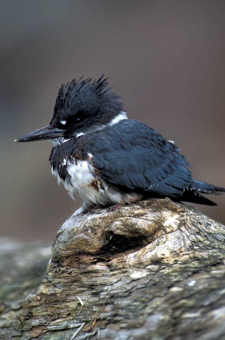
Other riparian birds, like the belted kingfisher, are fish-eaters. This handsome, crested, steel blue bird can be seen perched in the trees next to the Logan River eying fish beneath the surface. At times, kingfishers will hover directly above the water announcing their presence with a loud, rattling call. At the right time, the kingfisher dives headlong into the river using its long, sharp beak like a tweezers to catch small fish.
Rivers, like the Logan, and their riparian zones, support some of the richest biological diversity in the West. They are forceful and ever-changing, but provide all that life needs to survive and thrive in a compact area. These are dynamic ribbons of green and blue that connect land to water, plants to animals, and humans to nature.
Williams, Stewart J. Lake Bonneville: Geology of Southern Cache Valley, Utah, Geological Survey Professional Paper 257-C, US Department of the Interior, 1962, https://pubs.usgs.gov/pp/0257c/report.pdf
Over fifteen thousand years ago, the glacially fed Logan River was flowing into Lake Bonneville which covered most of the NW quadrant of the state and completely filled Utah’s Cache Valley.
The river met the ancient Lake Bonneville some distance up Logan Canyon so it was much shorter. Animals that lived along the river included saber-toothed cats, woolly mammoths and giant ground sloths.
About ten thousand years later, after Lake Bonneville had disappeared, the Logan River meandered across the old lake bed and the Shoshone Native American tribe made Cache Valley their home.
Shoshone Women and Children. Photo taken in 1870, Unknown photographer. Courtesy USU Digital History Collections.Frank Howe, chairman of the Logan River Task Force, adjunct associate professor, and university liaison for Utah Division of Wildlife Resources said, “When people say ‘let’s return Cache Valley to how it was naturally’ they don’t realize the valley [had been] managed by the Shoshone for thousands of years before the settlers arrived.”
The Shoshone burned the valley frequently to drive the Bison and provide better forage for their horses. This impacted the vegetation across the valley and along the river. Instead of large stands of tall trees, the river was lined with shrubs which responded better to fire, hence the valley’s first name Willow Valley.
Water flowing in Right-hand Fork one of the tributaries of Logan River. Courtesy & Copyright Shauna LeavittDuring this time the flow and movement of the Logan River was much different, in part because of the beaver families who built their homes and dams up and down the waterway. The dams created ponds whose waters seeped into the valley bottoms raising the water table and saturating the sponge. Joseph Wheaton, associate professor of the Department of Watershed Sciences in the Quinney College of Natural Resources explained, “the saturated ground increased resilience to drought, flood and fire.”
In the early 1800s trappers arrived in the valley.
Michel Bourdon was one of the earliest trappers to see Cache Valley around 1818. The river was, for a short time, named after him. A few years later, Ephraim Logan arrived in Cache Valley. He and many other trappers attended the Rocky Mountain Rendezvous along the Bourdon River in 1826. Shortly thereafter, Logan died during one of his outings and the area’s trappers decided to rename the river Logan, in his honor.
Trapping for the fur industry severely impacted the beaver population and the Logan River. The dam building beavers were almost trapped to extinction because of the European fashion demand. Luckily, fashion trends changed before beaver were extinct. However, the virtual elimination of beavers fundamentally changed the character of the Logan River to this day.
Man fly-fishing in Logan River, Logan Canyon, Utah, July 21, 1937. Courtesy of USU Digital History Collections.In the 1850s the first settlers arrived in Cache Valley. Their arrival had a large impact on Logan River. Within a year they began constructing the first canal for irrigation.
Logan’s Main Street about 1920, Courtesy of Darrin SmithAround the turn of the 19th century it became apparent the grazing and timber need of the settlers had been hard on the Logan River and the surrounding landscape. Albert F. Potter surveying the Logan River watershed for President Theodore Roosevelt, reported the canyon had been overgrazed and its timber overcut. The timber, at the time, was used for railroad ties and to build Logan City.
Logan Canyon about 1910. Four waterways: the aquaduct which was used for power generation, the canal, a water way that ran behind the building which had been part of the old Hercules Power Plant, and the Logan River. Photographer H.G. Hutteballe, Courtesy of Darrin Smith Photo CollectionAs the valley’s population grew, so did the demand for Logan River water.
Color enhanced photo 1910 photo of Logan Canyon Courtesy Logan LibraryOver the next few months, Wild About Utah will continue this series on the Logan River to tell the stories about its ecology, social value, and how humans have worked together to make it a community amenity not just a canal.
We hope you’ll join us as we learn more interesting facts about Logan River.
Williams, Stewart J. Lake Bonneville: Geology of Southern Cache Valley, Utah, Geological Survey Professional Paper 257-C, US Department of the Interior, 1962, https://pubs.usgs.gov/pp/0257c/report.pdf