Along the Wasatch Front
Courtesy Utah Division of Air Quality
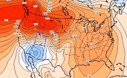
 Air Pressure at the Surface, 1 Dec 2011
Blue=Low Pressure, Red=High Pressure
The spacing of the lines is a measure of the pressure gradient: the closer the lines, the higher the pressure gradient. https://climate.usurf.usu.edu/news/010512Utah%20Climate%20Update%20(Jan%2012).pdf[Feb 6, 2014]
Read: A Bit of a Blow…
Courtesy Utah Climate Center, Utah State University
Wind is inevitable on a spinning planet with an atmosphere and a sun. At our latitude, westerlies prevail, but east winds do occur now and then. Locally, canyons daily exhale denser, cooler mountain air that drains into valleys. In Logan, trees blown by these canyon winds tilt westward. Occasionally, though, the whole Wasatch front is whipped by howling gales from the east, leaving behind shredded shingles, snapped tree limbs and rolled tractor-trailers. These forceful east wind events have a regional weather origin that is intensified by local topography.
It begins with a strong high-pressure cell parked over southwestern Wyoming. It’s descending dry air circulates clockwise. Somewhere to the south or southwest, a low-pressure cell is needed. The strong air pressure gradient between high and low generates a wind that races westward from Wyoming. The surging wind pours over the entire Wasatch front like water over a flat boulder in rapids. These winds then plunge down slope, blowing quickest where the descent is long, steep, and unobstructed. The down rushing air slams onto the flat benches and valley floors. In November 2011, such winds ripped Centerville with 100 MPH gusts.
Where these so-called mountain wave events blow regularly they often have names. The mistral and foehn winds howl down from the Alps, chinooks race down the Rocky Mountain Front Range, and the Santa Anas blast Southern California. The steep altitudinal descent of these parched winds compressively heats the air. A spark or flame soon transforms to a raging wildfire when fanned by a drying foehn or Santa Ana wind. Europe’s foehns are also known to spark short tempers and stress.
Perhaps the sporadic easterly gales that lash the Wasatch Front and Cache Valley deserve an evocative name too. For now, you at least know the answer to what’s blowin’ in the east wind.
Thanks to Martin Schroeder at the Utah Climate Center for insights and the stream boulder analogy
This is Linda Kervin for Bridgerland Audubon Society.
Credits:
Diurnal Utah Winds Image: Courtesy Utah Division of Air Quality
Surface Air Pressure 1 Dec 2011 Image: Courtesy Utah Climate Center, USU
Text: Jim Cane
Additional Reading:
Martin Price, Alton Byers, Donald Friend, Thomas Kohler, Larry W. Price. 2013. Mountain Geography: Physical and Human Dimensions. Univ of California Press. pages 7174. https://www.amazon.com/Mountain-Geography-Physical-Human-Dimensions/dp/0520254317
Mesmerizing live wind map of US at: https://hint.fm/wind/
Forecast of damaging east winds along the Wasatch Front, end of November 2011, https://www.ksl.com/?sid=18282965
How Chinooks Occur, Wikipedia, https://en.wikipedia.org/wiki/Chinook_wind#How_Chinooks_occur
