American White Pelicans

American White Pelicans at the Bear River Migratory Bird Refuge Courtesy & Copyright © Mary Heers
Pelicans at the Bear River Migratory Bird Refuge
Courtesy & Copyright © Mary Heers

American White Pelicans Fishing at the Bear River Migratory Bird Refuge Courtesy & Copyright © Mary Heers American White Pelicans Fishing
at the Bear River Migratory Bird Refuge
Courtesy & Copyright © Mary Heers

Jordan Falslev's Pelican Perch at the Benson Marina on Cutler Reservoir, Click to view a larger image. Courtesy & Copyright © Mary Heers 
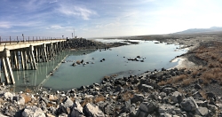
Jordan Falslev’s Pelican Perch
at the Benson Marina on Cutler Reservoir,
Click to view a larger image.
Courtesy & Copyright © Mary Heers

I first caught sight of the eight pelicans swimming in s straight line towards the waters edge, looking a lot like a tank division in in an old WWII movie I slammed on the brakes just in time to see them all dip their bills into the water, come up spilling water and cock their heads back And then, gulp! Fish slid down their throats.

Wow, I thought. These pelicans are working together to to drive the fish into the shallow water’s edge where they can easily scoop the up And then it got better. Fanning out, the pelicans regrouped in a circle Swimming towards the center, they tightened the noose. And bam! Dip, scoop, knock back some more fish

I was amazed at how soundless and seamless it all was and could have watched for hours, but I was on the one lane auto route at the Bear River Migratory Bird Refuge and the cars behind me were starting to honk their horns, so I reluctantly moved on.

As soon as I got home I plunged into research on this majestic bird, beginning with the bill. When the pelican dips its bill into the water, the lower portion expands into a flexible sac that allows the bird to to scoop up as much as 3 gallons of fish and water. When the pelican cocks back its head, the sac contracts, the water is expelled through a barely open bill, and the fish swallowed. The huge pelican bill, which at first glance looks like a formidable weapon, is actually an exquisitively designed fishing net.

Archeologists have found pelican skulls dating back 30 million years, so this unique bill has definitely passed the test of time.

Back at the refuge I was able to turn into a visitor pull out and pick up the rather stunning bit of information: these pelicans fly in from Gunnison Island in the Great Salt Lake, over the Promontory Mountains, daily to forage for fish. That’s a 30 mile trip each way!

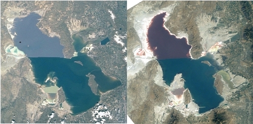
Long before the Mormon pioneers arrived in Utah, pelicans were building their nest on Gunnison Island. They were briefly disturbed when an artist, Albert Lambourne, tried to homestead for a year in 1850, and a guano mining company dropped off a crew – a Pole, a Russian, a Scot and an Englishman- to mine the bird poop. But the operation wasn’t profitable, and when it closed down, the pelicans reclaimed the island. Each March the birds fly in from as far away as Mexico, build their nests, and raise their chicks. The rookery is the largest in the US. In 2017 the pop was estimated to be as high as 20,000.

Back in Cache Valley in 2010, Jordan Falslev built a viewing platform near Benson Marina, The Pelican Perch, as his Eagle scout project. There used to be hundreds of pelicans out there on the water, but when I stopped by last week I didn’t see a single one. Numbers are way down now largely because the dropping water level in the Great Salt Lake have exposed a land bridge to Gunnison Island that allows predators to ravage the nesting site.

You can still catch sight of a pelican in flight in Cache Valley. (Their wingspan is 10 ft. Rudy Gobert, in comparison, has a wingspan of 7 ft 9 in.) But for my money, the best show in town is watching packs of pelicans hunt for fish at the Bear River Migratory Bird refuge.

This is Mary Heers and I am Wild About Utah.

Credits:

Photos: Courtesy & Copyright © Mary Heers
Featured Music: Courtesy & Copyright © Anderson, Howe, Wakeman
Text: Mary Heers
Voice: Mary Heers

Additional Reading

American White Pelican Pelecanus erythrorhynchos, Species, Utah Division of Wildlife Management, Utah Department of Natural Resources, https://fieldguide.wildlife.utah.gov/?species=pelecanus%20erythrorhynchos [Link updated January 2024]

American White Pelican (AWPE), Aquatic Birds, Great Salt Lake Bird Survey 1997-2001, Utah Division of Wildlife Management, https://wildlife.utah.gov/gsl/waterbirdsurvey/awpe.htm

Larsen, Leia, As Great Salt Lake shrinks, fate of nesting pelicans unknown, Standard Examiner, October 11, 2015, https://www.standard.net/news/environment/2015/oct/11/as-great-salt-lake-shrinks-fate-of-nesting-pelicans-unknown/ [Link updated January 2024]

Butler, Jaimi, The Great Salt Lake Is An ‘Oasis’ For Migratory Birds, Science Friday, September 21, 2018, https://www.sciencefriday.com/segments/the-great-salt-lake-is-an-oasis-for-migratory-birds/

Hager, Rachel, Great Salt Lake Pelicans Under Threat, Utah Public Radio, May 28, 2018, https://www.upr.org/post/great-salt-lake-pelicans-under-threat

Leefang, Arie, Gunnison Island, Heritage and Arts, Utah Division of State History, September 16, 2019, https://history.utah.gov/exploring-the-history-and-archaeology-of-the-great-salt-lakes-gunnison-island/

Hoven, Heidi, Gunnison Island: Home of up to 20,000 nesting American White Pelicans, Audubon California, National Audubon Society, September 25, 2017, https://ca.audubon.org/news/gunnison-island-home-20000-nesting-american-white-pelicans

The Great Salt Lake–A Giant Among Us

A Giant Among Us, The Great Salt Lake: The Great Salt Lake Breach
The Great Salt Lake Breach
Courtesy U.S. Geological Survey
Department of the Interior/USGS
Mike Freeman, Photographer
10 Nov 2015
Water flowing through the Great Salt Lake breach in 2011, when lake levels were high due to above average snowfall in the Wasatch and Uinta Mountains. The Great Salt Lake breach is an area that allows water to travel between the southern and northern parts of the lake.
There is a giant among us with a profound influence on our past, present, and future. My first encounter with this giant was both buoyant and delightful as I floated in the brine on a lovely summer day. But I was oblivious to the Great Salt Lake’s immense value as an environmental, cultural, and economic resource.

A Giant Among Us–The Great Salt Lake

Much of what follows is taken from a very recently released collaborative study titled “Impacts of Water Development on Great Salt Lake and the Wasatch Front” which was a collaborative effort from four institutions(Utah State University, Utah Division of Water Resources, Salt Lake Community College, and the Utah Division of Wildlife Resources.)

A 2012 analysis by Bioeconomics estimated the economic value of the lake at $1.32 billion per year for mineral extraction, brine shrimp cyst production, and recreation. The abundant food and wetlands of the lake attract 3 million shorebirds, as many as 1.7 million eared grebes, and hundreds of thousands of waterfowl during spring and fall migrations. Because of this, it has been designated as a Western Hemisphere Shorebird Reserve Network Site. Due to its enormous surface area, it produces the “lake affect” which enhances our snow pack by an estimated 8%, a significant amount for both skiers and our available water. But our giant is shrinking.

Since the arrival of 19th Century pioneers water diversions for irrigation have decreased its elevation by 11 feet exposing much of the lake bed. Natural fluctuations in rainfall and river flow cause the lake level to rise and fall, but there has been no significant long‐term change in precipitation and water supply from the main tributaries since their coming in 1847.

The Great Salt Lake Breach 2015
The Great Salt Lake Breach
Credit: U.S. Geological Survey
Department of the Interior/USGS
Mike Freeman, Photographer
10 Nov 2015

For the first time since it was opened in 1984, water has stopped flowing through the Great Salt Lake causeway breach, an area that allows water to travel between the southern and northern parts of the lake.
To significantly reduce water use, a balanced conservation ethic needs to consider all uses, including agriculture, which consumes 63 percent of the water in the Great Salt Lake Basin. There are no water rights to protect our Great Lake, so water development currently focuses solely on whether there is water upstream to divert. If future water projects reduce the supply of water to the lake, (such as the Bear River Development Project, its level will (most likely) continue to drop.

We must look beyond the next few decades and decide how we value the lake for future generations. Lower lake levels will increase dust pollution and related human health impacts, and reduce industrial and environmental function of Great Salt Lake. We must be willing to make decisions now that preserve Great Salt Lake’s benefits and mitigate its negative impacts into the coming centuries.

John Muir, one of my favorite early American naturalists would most certainly agree with me. From his baptismal plunge into the Great Salt Lake. “I found myself undressed as someone else had taken me in hand and got myself into right lusty relationship with the brave old lake. I was conscious only of a joyous exhilaration….”
And where else could John and I have such a wonderfully buoyant experience?

This is Jack Greene reading for Wild About Utah.

2015 Great Salt Lake Breach at Lakeside, Utah
Gauge near the Great Salt Lake Breach
Credit: U.S. Geological Survey
Department of the Interior/USGS
Mike Freeman, Photographer
10 Nov 2015
A gauge to measure lake water levels stands dry in the lake bed of the Great Salt Lake. For the first time since it was opened in 1984, water has stopped flowing through the Great Salt Lake causeway breach, an area that allows water to travel between the southern and northern parts of the lake.
Credits:
Image: Courtesy U.S. Department of the Interior, U.S. Geological Survey(USGS), gallery.usgs.gov
Text:     Jack Greene, Bridgerland Audubon Society & USU Office of Sustainability

Additional Reading:

Great Salt Lake, Utah, Stephens, Doyle W. and Gardner, Joe, USGS Science for a Changing World, https://pubs.usgs.gov/wri/wri994189/PDF/WRI99-4189.pdf

Salt Lake Brine Shrimp, https://saltlakebrineshrimp.com/harvest/

Great Salt Lake Footprint 2001 vs 2003 Comparison
Great Salt Lake Footprint Comparison
2001 vs 2003
Images Courtesy NASA
NASA’s Earth Observatory

There is a Giant Among Us–The Great Salt Lake

A Giant Among Us, The Great Salt Lake: The Great Salt Lake Breach
The Great Salt Lake Breach
Courtesy U.S. Geological Survey
Department of the Interior/USGS
Mike Freeman, Photographer
10 Nov 2015
Water flowing through the Great Salt Lake breach in 2011, when lake levels were high due to above average snowfall in the Wasatch and Uinta Mountains. The Great Salt Lake breach is an area that allows water to travel between the southern and northern parts of the lake.
There is a giant among us with a profound influence on our past, present, and future. My first encounter with this giant was both buoyant and delightful as I floated in the brine on a lovely summer day. But I was oblivious to the Great Salt Lake’s immense value as an environmental, cultural, and economic resource.

A Giant Among Us–The Great Salt Lake

Much of what follows is taken from a very recently released collaborative study titled “Impacts of Water Development on Great Salt Lake and the Wasatch Front” which was a collaborative effort from four institutions(Utah State University, Utah Division of Water Resources, Salt Lake Community College, and the Utah Division of Wildlife Resources.)

A 2012 analysis by Bioeconomics estimated the economic value of the lake at $1.32 billion per year for mineral extraction, brine shrimp cyst production, and recreation. The abundant food and wetlands of the lake attract 3 million shorebirds, as many as 1.7 million eared grebes, and hundreds of thousands of waterfowl during spring and fall migrations. Because of this, it has been designated as a Western Hemisphere Shorebird Reserve Network Site. Due to its enormous surface area, it produces the “lake affect” which enhances our snow pack by an estimated 8%, a significant amount for both skiers and our available water. But our giant is shrinking.

Since the arrival of 19th Century pioneers water diversions for irrigation have decreased its elevation by 11 feet exposing much of the lake bed. Natural fluctuations in rainfall and river flow cause the lake level to rise and fall, but there has been no significant long‐term change in precipitation and water supply from the main tributaries since their coming in 1847.

The Great Salt Lake Breach 2015
The Great Salt Lake Breach
Credit: U.S. Geological Survey
Department of the Interior/USGS
Mike Freeman, Photographer
10 Nov 2015

For the first time since it was opened in 1984, water has stopped flowing through the Great Salt Lake causeway breach, an area that allows water to travel between the southern and northern parts of the lake.
To significantly reduce water use, a balanced conservation ethic needs to consider all uses, including agriculture, which consumes 63 percent of the water in the Great Salt Lake Basin. There are no water rights to protect our Great Lake, so water development currently focuses solely on whether there is water upstream to divert. If future water projects reduce the supply of water to the lake, (such as the Bear River Development Project, its level will (most likely) continue to drop.

We must look beyond the next few decades and decide how we value the lake for future generations. Lower lake levels will increase dust pollution and related human health impacts, and reduce industrial and environmental function of Great Salt Lake. We must be willing to make decisions now that preserve Great Salt Lake’s benefits and mitigate its negative impacts into the coming centuries.

John Muir, one of my favorite early American naturalists would most certainly agree with me. From his baptismal plunge into the Great Salt Lake. “I found myself undressed as someone else had taken me in hand and got myself into right lusty relationship with the brave old lake. I was conscious only of a joyous exhilaration….”
And where else could John and I have such a wonderfully buoyant experience?

This is Jack Greene reading for Wild About Utah.

2015 Great Salt Lake Breach at Lakeside, Utah
Gauge near the Great Salt Lake Breach
Credit: U.S. Geological Survey
Department of the Interior/USGS
Mike Freeman, Photographer
10 Nov 2015
A gauge to measure lake water levels stands dry in the lake bed of the Great Salt Lake. For the first time since it was opened in 1984, water has stopped flowing through the Great Salt Lake causeway breach, an area that allows water to travel between the southern and northern parts of the lake.
Credits:
Image: Courtesy U.S. Department of the Interior, U.S. Geological Survey(USGS), gallery.usgs.gov
Text:     Jack Greene, Bridgerland Audubon Society & USU Office of Sustainability

Additional Reading:

Great Salt Lake, Utah, Stephens, Doyle W. and Gardner, Joe, USGS Science for a Changing World, https://pubs.usgs.gov/wri/wri994189/PDF/WRI99-4189.pdf

Salt Lake Brine Shrimp, https://saltlakebrineshrimp.com/harvest/

Great Salt Lake Footprint 2001 vs 2003 Comparison
Great Salt Lake Footprint Comparison
2001 vs 2003
Images Courtesy NASA
NASA’s Earth Observatory

The Great Salt Lake

The Great Salt Lake Breach
Courtesy U.S. Geological Survey
Department of the Interior/USGS
Mike Freeman, Photographer
10 Nov 2015
Water flowing through the Great Salt Lake breach in 2011, when lake levels were high due to above average snowfall in the Wasatch and Uinta Mountains. The Great Salt Lake breach is an area that allows water to travel between the southern and northern parts of the lake.
There is a giant among us with a profound influence on our past, present, and future. My first encounter with this giant was both buoyant and delightful as I floated in the brine on a lovely summer day. But I was oblivious to the Great Salt Lake’s immense value as an environmental, cultural, and economic resource.

Much of what follows is taken from a very recently released collaborative study titled “Impacts of Water Development on Great Salt Lake and the Wasatch Front” which was a collaborative effort from four institutions(Utah State University, Utah Division of Water Resources, Salt Lake Community College, and the Utah Division of Wildlife Resources.)

A 2012 analysis by Bioeconomics estimated the economic value of the lake at $1.32 billion per year for mineral extraction, brine shrimp cyst production, and recreation. The abundant food and wetlands of the lake attract 3 million shorebirds, as many as 1.7 million eared grebes, and hundreds of thousands of waterfowl during spring and fall migrations. Because of this, it has been designated as a Western Hemisphere Shorebird Reserve Network Site. Due to its enormous surface area, it produces the “lake affect” which enhances our snow pack by an estimated 8%, a significant amount for both skiers and our available water. But our giant is shrinking.

Since the arrival of 19th Century pioneers water diversions for irrigation have decreased its elevation by 11 feet exposing much of the lake bed. Natural fluctuations in rainfall and river flow cause the lake level to rise and fall, but there has been no significant long‐term change in precipitation and water supply from the main tributaries since their coming in 1847.

The Great Salt Lake Breach 2015
The Great Salt Lake Breach
Credit: U.S. Geological Survey
Department of the Interior/USGS
Mike Freeman, Photographer
10 Nov 2015

For the first time since it was opened in 1984, water has stopped flowing through the Great Salt Lake causeway breach, an area that allows water to travel between the southern and northern parts of the lake.
To significantly reduce water use, a balanced conservation ethic needs to consider all uses, including agriculture, which consumes 63 percent of the water in the Great Salt Lake Basin. There are no water rights to protect our Great Lake, so water development currently focuses solely on whether there is water upstream to divert. If future water projects reduce the supply of water to the lake, (such as the Bear River Development Project, its level will (most likely) continue to drop.

We must look beyond the next few decades and decide how we value the lake for future generations. Lower lake levels will increase dust pollution and related human health impacts, and reduce industrial and environmental function of Great Salt Lake. We must be willing to make decisions now that preserve Great Salt Lake’s benefits and mitigate its negative impacts into the coming centuries.

John Muir, one of my favorite early American naturalists would most certainly agree with me. From his baptismal plunge into the Great Salt Lake. “I found myself undressed as someone else had taken me in hand and got myself into right lusty relationship with the brave old lake. I was conscious only of a joyous exhilaration….”
And where else could John and I have such a wonderfully buoyant experience?

This is Jack Greene reading for Wild About Utah.

2015 Great Salt Lake Breach at Lakeside, Utah
Gauge near the Great Salt Lake Breach
Credit: U.S. Geological Survey
Department of the Interior/USGS
Mike Freeman, Photographer
10 Nov 2015
A gauge to measure lake water levels stands dry in the lake bed of the Great Salt Lake. For the first time since it was opened in 1984, water has stopped flowing through the Great Salt Lake causeway breach, an area that allows water to travel between the southern and northern parts of the lake.
Credits:
Image: Courtesy U.S. Department of the Interior, U.S. Geological Survey(USGS), gallery.usgs.gov
Text:     Jack Greene, Bridgerland Audubon Society & USU Office of Sustainability

Additional Reading:

Great Salt Lake, Utah, Stephens, Doyle W. and Gardner, Joe, USGS Science for a Changing World, https://pubs.usgs.gov/wri/wri994189/PDF/WRI99-4189.pdf

Salt Lake Brine Shrimp, https://saltlakebrineshrimp.com/harvest/

Great Salt Lake Footprint 2001 vs 2003 Comparison
Great Salt Lake Footprint Comparison
2001 vs 2003
Images Courtesy NASA
NASA’s Earth Observatory