Snowflakes

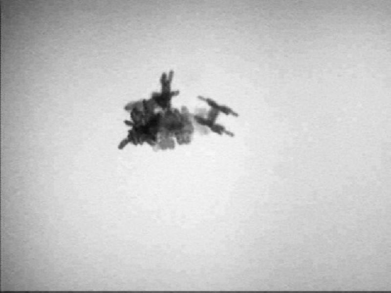
A free-falling snow crystal photographed as it fell on Alta Ski Area on March 6, 2011, Photo Courtesy & Copyright Tim Garrett, University of Utah
A free-falling snow crystal
photographed as it fell
Alta Ski Area on March 6, 2011
Photo Courtesy & Copyright 2011
Tim Garrett, University of Utah
Alta Snowflake Showcase

As winter draws to a close, I’d like to take a moment to reflect on the amazing weather phenomenon that is a snowflake. When winter weather dumps inches of snow on us, it’s easy to overlook the tiny works of art, those intricate and delicate snowflakes, which make up the storm.

Snowflakes – or to use a more scientific term, snow crystals – come in a variety of different shapes including long, thin needles, flat hexagonal plates, columns, and irregularly-shaped pellets called graupel. The International Snow Classification System recognizes ten different shapes in all, only one of which is the traditional snowflake image. The classic six-armed snowflake shape is called a ‘stellar dendrite’ by scientists.

When teaching programs about snow, someone inevitably asks me, “Is it really true that no two snowflakes are alike?” As far as I can tell, the answer is, well, ‘maybe’, and here’s why.
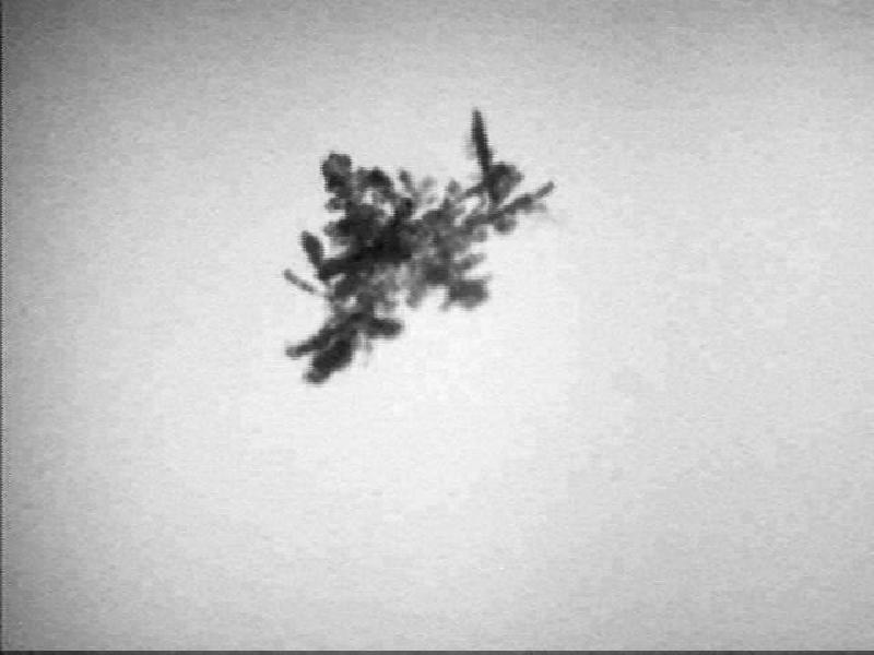
A free-falling snow crystal photographed as it fell, Alta Ski Area, March 6, 2011, Photo Courtesy and Copyright 2011, Tim Garrett, University of Utah, Alta Snowflake Showcase, https://alta.com/pages/snowflakeshowcase.php
A free-falling snow crystal
photographed as it fell
Alta Ski Area
March 6, 2011
Photo Courtesy & Copyright 2011
Tim Garrett, University of Utah
Alta Snowflake Showcase

Three things are needed to form these intricate crystals, and the first two are fairly obvious: water, and temperatures below freezing. The third item is a little more inconspicuous. Water cannot condense and freeze all on its own. Every snowflake needs a piece of atmospheric dust or salt at its core. This particle is referred to as a ‘nucleating agent,’ and it attracts water molecules which then condense and begin to freeze. From there, a snowflake’s overall shape is determined by a number of other variables including the atmospheric temperature, the amount of available moisture, wind speed, and mid-air collisions with other snowflakes.

To add more complexity, consider that each individual snowflake contains somewhere on the order of 10 quintillion water molecules. That’s ten with eighteen zeros behind it. While the way these molecules bind to each other is dictated by the laws of physics, the sheer number of ways in which 10 quintillion water molecules can arrange themselves as they freeze into place is mind boggling. But then again, how many snowflakes do you think fall in the typical March snowstorm in Utah? A lot. One scientist has estimated that the number of individual snowflakes that have fallen on Earth in the planet’s history is ten with 34 zeros behind it. In all of those snowflakes is it possible that two are exactly alike? Yeah, maybe… but good luck finding them!
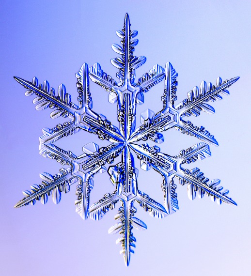
A stellar dendrite snow crystal, Photo Courtesy and Copyright Kenneth Libbrecht, Caltech University, SnowCrystals.com, https://www.its.caltech.edu/~atomic/snowcrystals/photos/photos.htm
A stellar dendrite snow crystal Photo Courtesy & Copyright
Kenneth Libbrecht, Caltech University
SnowCrystals.com

For more information and some beautiful snowflake photographs, please visit our website at www.wildaboututah.org. Thank you to the Rocky Mountain Power Foundation for supporting the research and development of this Wild About Utah topic.

For the Stokes Nature Center and Wild About Utah, this is Andrea Liberatore.

Credits:

Photos: Courtesy Tim Garrett, University of Utah,
Kenneth Libbrecht, Caltech University
Text: Andrea Liberatore, Stokes Nature Center

Additional Reading:

Halfpenny, J.C and Ozanne, R.D. 1989. Winter: An Ecological Handbook. Boulder, CO: Johnson Books, https://www.amazon.com/Winter-Ecological-Handbook-James-Halfpenny/dp/1555660363
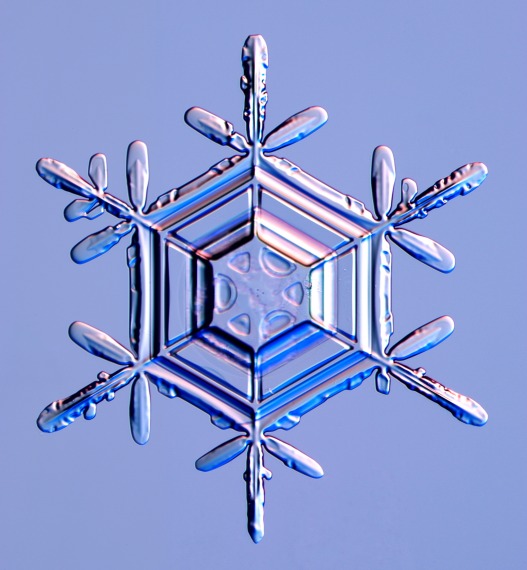
A stellar dendrite snow crystal, Photo Courtesy and Copyright Kenneth Libbrecht, Caltech University, SnowCrystals.com, https://www.its.caltech.edu/~atomic/snowcrystals/photos/photos.htm
A stellar dendrite snow crystal Photo Courtesy & Copyright
Kenneth Libbrecht, Caltech University
SnowCrystals.com

Gosnell, Mariana. 2007. Ice: the Nature, the History, and the Uses of an Astonishing Substance. Chicago, IL: The University of Chicago Press, https://www.amazon.com/Ice-Nature-History-Astonishing-Substance/dp/0679426086

Libbrecht, Kenneth .1999. A Snowflake Primer: the basic facts about snowflakes and snow crystals. https://www.its.caltech.edu/~atomic/snowcrystals/primer
/primer.htm


A hexagonal plate snow crystal, Photo Courtesy and Copyright Kenneth Libbrecht, Caltech University, SnowCrystals.com, https://www.its.caltech.edu/~atomic/snowcrystals/photos/photos.htm
A hexagonal plate snow crystal cite>Photo Courtesy & Copyright
Kenneth Libbrecht, Caltech University
SnowCrystals.com
Investigating the Causes of Wildfires

Investigating the Causes of Wildfires: A wildfire near Hyrum, UT, Courtesy & Copyright 2013 Holly Strand, Photographer

Wildfire near Hyrum, UT
Showing Fixed-Wing Retardant Drop
Courtesy & Copyright 2013
Holly Strand, Photographer

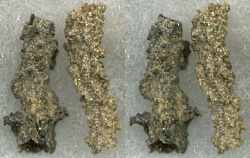
Fulgurites, caused by lightning
Courtesy Wikimedia Commons,
John Elson, Photographer
Licensed under GNU Free Documentation License v 1.2

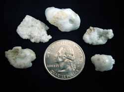
Utah Sand Fulgurites
Found on Mount Raymond
Courtesy Utah Geological Survey
Carl Ege, Photographer

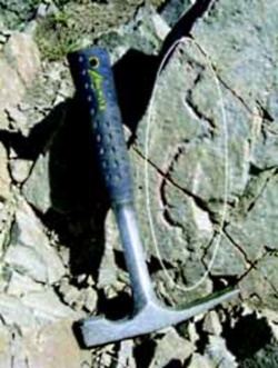
Rock Fulgurite (circled)
Found on quartzite at the summit of
Mount Raymond, Wasatch Range,
Salt Lake County, UT.
Courtesy Utah Geological Survey
Carl Ege, Photographer

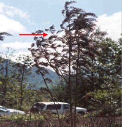
‘Frozen’ leaves pointing in the direction of prevailing winds during the passage of the fire.
From the ‘Wildfire Origin & Cause Determination Handbook’
Courtesy National Wildfire Coordinating Group(NCGW.gov)

Hi I’m Holly Strand of Utah State University’s College of Natural Resources.

It’s fire season in UT. The hill slopes have turned a parched yellow-brown and the trees look thirsty and flammable. As of Aug. 13, there were 7 fires burning across the state.

One of the first questions that arises with any wildfire is “What started it?”

And I wonder: “How in the world would you figure this out given the destruction that a fire leaves in its wake?”

The first step toward identifying a cause involves finding the exact spot where the fire started. To do this, investigators look for witnesses. And having information on wind direction for the duration of the fire helps a lot. But even in the absence of these, the fire itself leaves clues regarding the direction of movement. And if you know the direction of movement, you can trace the path backwards to the ignition site.

For instance, on a tree or post, the side exposed to the oncoming fire will show deeper charring, more loss of wood and more white ash than the unexposed side.

However the leeward side of a tree may have the highest char mark. That’s because as strong winds blows the fire past a tree, the flames are drawn into the eddy zone on the leeward side and extend higher up the trunk. Still, the deeper char will be on the side facing the advancing flame. So to get to the area of the fire origin, you’d want to follow direction indicated by the most damaged tree face.

When green leaves of shrubs or trees are scorched, they tend to become soft and pliable and bend in the direction of the prevailing wind. After the fire passes they become fixed in this position as they cool, still pointing in the direction of the wind. So the opposite direction of the pointing leaves will take you closer to the fire origin.

Another thing that generally helps fire investigators is the fact that all fires need time to achieve their maximum spread rate/intensity. A newly ignited fire may take 30 min or more to ramp up. As a result even with high intensity fires, the area of initial ignition will show relatively less damage; upper foliage and branches may even remain intact.

Once the area of origin is identified, investigators look for the human or natural source of the blaze. Footprints, tire marks or evidence of a campfire are noted with interest. Nearby power lines, railroad tracks or electric fences may have provided the initial spark. Investigators often end up on their hands and knees searching for things such as cigarette parts, ignitable liquid residue; bullets or empty shell casings.

If lightening is a suspected source investigators look for strike marks or splintered wood fragments. Lightening can also leave a glassy residue, called a fulgurite, when the strike melts sand on the ground or on vegetation.

Thanks to Wesley Page of USU’s Department of Wildland Resources for sharing his wildfire expertise.

For sources and more information on investigating the cause of wildfires go to www.wildaboututah.org

For Wild About Utah and USU’s College of Natural Resources, I’m Holly Strand.

Credits:

Images: Hyrum Fire, Courtesy & Copyright 2013 Holly Strand
Courtesy Wikimedia, John Elson, Licensed under GNU Documentation License V1.2
Also images from Wildfire Origin & Cause Determination Handbook, Courtesy National Wildfire Coordinating Group(NCGW.gov)
Text: Holly Strand

Sources & Additional Reading

Cheney, Phil and Andrew Sullivan. Grassfires: Fuel, weather and fire behavior. 2008. CSIRO. https://www.amazon.com/Grassfires-Fuel-Weather-Fire-Behaviour/dp/0643093834

Wildfire Origin & Cause Determination Handbook. 2005. A publication of the National Wildfire Coordinating Group Fire Investigation Working Team NWCG Handbook 1. PMS 412-1. May 2005. https://www.nwcg.gov/pms/pubs/nfes1874/nfes1874.pdf

Investigating Wildfires: Part One. Interfire online. https://web.archive.org/web/20240406114120/https://www.interfire.org/features/wildfires.asp
(https://www.interfire.org/features/wildfires.asp accessed August 14, 2013 — Updated Apr 17, 2025 and pointed to Waybackmachine archived content)

Investigating Wildfires: Part Two. Interfire online. https://web.archive.org/web/20240406114120/https://www.interfire.org/features/wildfires2.asp
(https://www.interfire.org/features/wildfires2.asp accessed August 14, 2013 — Updated Apr 17, 2025 and pointed to Waybackmachine archived content)

Map of current large active wildland fires in Utah.
(accessed August 14, 2013) https://www.utahfireinfo.gov/

Live Worldwide Network for Lightning and Thunderstorms in Real Time, Blitzortung, https://en.blitzortung.org/live_lightning_maps.php?map=30 [URL inactive as of 1 Aug 2020}]

Wildfire Investigation, Wildland fire investigation: common wildfire causes, National Interagency Fire Center, US Department of the Interior, https://www.nifc.gov/fire-information/fire-prevention-education-mitigation/wildfire-investigation

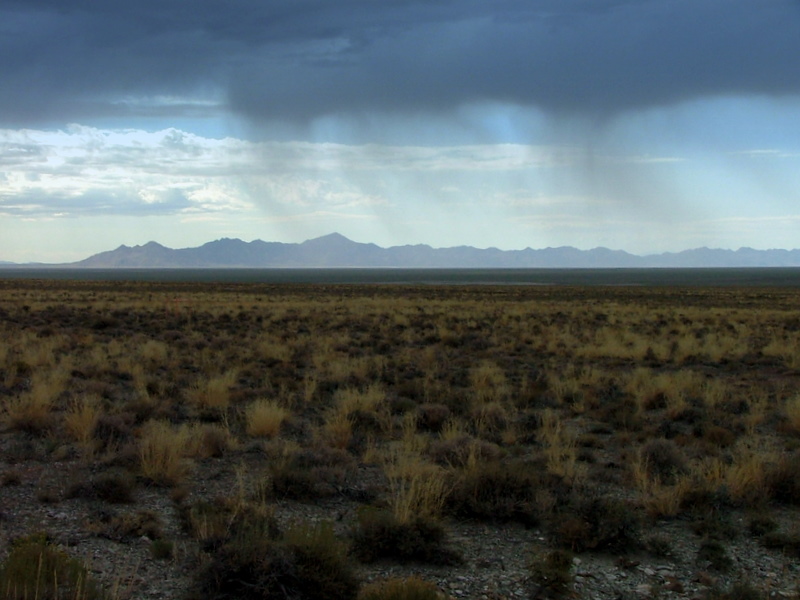
Virga

Virga courtesy and Copyright 2010 Kevin Connors
Virga
Courtesy & Copyright 2010 Kevin Connors
August is the perfect month to observe virga in Utah, for it is the monsoon season here. Moist subtropical air is flowing northward from the Pacific Ocean and the Gulf of California. When this warm, moist air is driven upward by convection and mountains, towering thunder heads result.

Below the bellies of these dark clouds you sometimes see grayish windswept curtains or streamers that do not reach the ground. Meteorologists call them “virga”, virga spelled with an “i”, from the Latin for “streak”. The word is absent from the prose of Mark Twain and the exploratory reports of John Wesley Powell because the word was only coined 70 years ago.

Click to view information from the : Virga in Cache Valley courtesy and Copyright 2010 Jim Cane
Virga in Cache Valley
Courtesy & Copyright 2010 Jim Cane

These picturesque virga are descending precipitation. One might guess it to be rain, but most meteorologists agree that it is frozen precipitation which is melting and evaporating as it drops through our dry Utah air. Like a home swamp cooler, evaporation causes cooling which leads to the chilly downdrafts that accompany our summer thunderstorms. In the humid tropics, rains can be lukewarm, but our summer cloudbursts are goose-bump cold, owing to the same evaporation which yields virga.

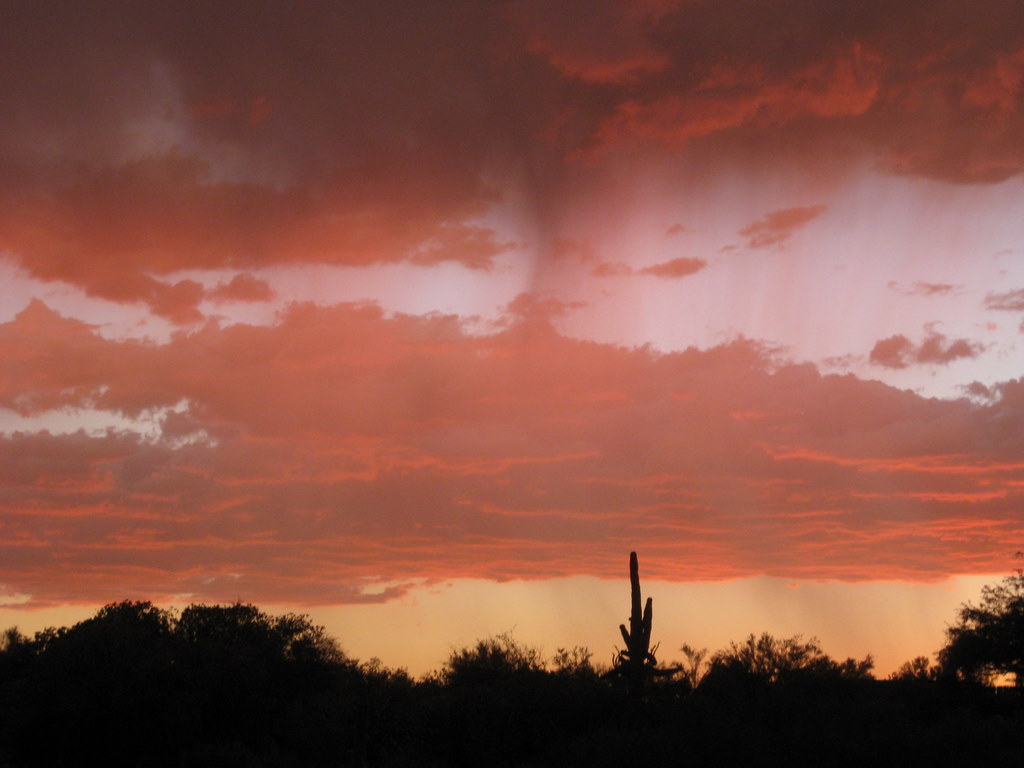
Virga are a tease for parched summer landscapes, a herald of wild fires ignited by dry lightning, and a generator of dust storms as downdrafts scour dusty salt flats. But mostly, the curtains of precipitation that are virga are a fleetingly beautiful element of our western summer skies, well worth a pause and a picture, especially if you are lucky enough to see one accompanied by a rainbow or a fiery sunset.

Click to view a larger picture of Virga in Tucson, AZ Courtesy & Copyright 2010 Julio Betancourt, Photographer
Virga in Tucson, AZ
Courtesy & Copyright 2010 Julio Betancourt

This is Linda Kervin for Bridgerland Audubon Society.
Credits:

Photos: Courtesy & Copyright 2010 Jim Cane
Courtesy & Copyright 2010 Julio Betancourt
Text: Jim Cane, Bridgerland Audubon Society

Additional Reading:

Jetstream, an online school for weather, NWS NOAA Southern Regional Headquarters, Ft worth, TX,
https://www.weather.gov/jetstream/atmos_intro

Virga in Tucson, AZ Courtesy & Copyright 2010 Julio Betancourt, Photographer
Virga in Tucson, AZ
Courtesy & Copyright 2010 Julio Betancourt

Fire weather: a guide for application of meteorological information to forest fire control operations, Mark J. Schroeder and Charles C. Buck, USDA Forest Service, https://training.nwcg.gov/pre-courses/S390/FireWeatherHandbook
/pms_425_Fire_Wx_ch_01.pdf

The Book of clouds, John A. Day, Sterling, 2005, https://www.amazon.com/Book-Clouds-John-Day/dp/1402728131

Live Worldwide Network for Lightning and Thunderstorms in Real Time, Blitzortung, https://en.blitzortung.org/live_lightning_maps.php?map=30 [Broken link removed 1 Aug 2020]

SNOTEL Snowpack Recording Stations

Manual Snow Measurement
Cover image from
Snow surveying by James C. Marr
USDA 1940 Publication 380
Public Domain
Courtesy UVA, Google & HathiTrust

For a modern view visit
https://www.meted.ucar.edu/afwa
/avalanche/print.htm

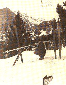
Removing snow surveying apparatus
from canvas carrying case
preparatory to use
From
Snow surveying by James C. Marr
USDA 1940 Publication 380
Public Domain
Courtesy UVA, Google & HathiTrust

Water is a precious resource throughout the world. Most of Utah consists of arid habitats and many users clamor for their share of the scarce moisture. Ever-growing demand challenges water managers to insure that agriculture, cities and nature all get their portion. Predicting and monitoring stream flow is imperative in order to know how much to hold in reservoirs or send downstream, and when to anticipate floods, enact water conservation measures, and in general provide for all users.

Much of Utah’s water originates in the mountain snowpack. Early in the twentieth century, the Department of Agriculture constructed a series of Snow Courses in mountainous areas of the West. Hardy personnel periodically trekked in to measure snow depth with a long ruled stick. Water content was found by taking a core sample, weighing it and subtracting out the weight of the metal tube. Stream gauging stations installed by the US Geological Survey allowed correlation of stream flows with snowpack measures.

In the 1970’s, monitoring snow courses became more automated. The reporting stations were named “SNOTEL” for snowpack telemetry. Now there are over 600 SNOTEL sites in 13 western states. The measurement functions of SNOTEL stations are elegantly simple and reliable. Air and soil temperatures are monitored with standard thermocouples. Water content of the snowpack is measured by its weight atop a broad thin bladder called a snow pillow that is filled with antifreeze. The snow pillow is carefully spread on the ground. Accumulating snow presses down on the pillow, pushing some antifreeze out a connecting tube to a pressure sensor.

Some SNOTEL sites also measure snow depth, using the autofocus technology of the digital camera. Subject distance is gauged by the time delay of an ultrasonic pulse, like sonar or hearing your voice echo back in a canyon. At a SNOTEL station, a similar sensor is placed high above the expected snow line. As snow accumulates, the downward facing sensor reports the shortening distance between it and the snow surface.

SNOTEL stations have batteries and a solar panel to power their hourly data transmissions. Ogden has one of the two master receiving stations. Want to size up mountain snowfall from the last storm or know how warmly to dress for an outing? Just go to Utah’s SNOTEL information site on the web.

Credits:

Image: Public Domain, Courtesy University of Virginia, Google and HathiTrust, Cover image from Snow surveying by James C. Marr, USDA 1940 Publication 380
Theme Music: Written by Don Anderson and performed by Leaping Lulu from their CD “High Road, Low Road”
Text: Jim Cane & Linda Kervin, Bridgerland Audubon Society https://www.bridgerlandaudubon.org
Voice: Linda Kervin, Bridgerland Audubon Society https://www.bridgerlandaudubon.org
Additional Reading:

Water Conservation Begins with Snow Surveys, USDA NRCS, https://www.wcc.nrcs.usda.gov/factpub/wc_ss.html

Snow Hydrology: SNOTEL, Randall Julander, Civil & Environmental Engineering, University of Utah, (formerly at https://www.civil.utah.edu/~cv5450/snotel/snotel.htm)

Utah Snow Survey Program, USDA NRCS, https://www.ut.nrcs.usda.gov/snow/

NRCS Snow Surveyor Collects Vital Water Data, Lives Dream Job, Spencer Miller, NRCS, Jan 10, 2013, https://www.nrcs.usda.gov/wps/portal/nrcs/detail/national/home/?cid=STELPRDB1076993

Snow Surveys and Water Supply Forecasting, National Atlas of the United States, US Department of the Interior, formerly at https://www.wcc.nrcs.usda.gov/factpub/sect_4a.html

Utah Snow Survey Program, Natural Resources Conservation Service, US Department of the Interior, https://www.nrcs.usda.gov/utah/snow-survey

Map, Utah USGS SNOTEL Stations https://www.wcc.nrcs.usda.gov/snotel/Utah/utah.html