Cryptobiotic Soil Crusts

Cryptobiotic Soil Crust
Photo Courtesy & Copyright 2009
Mark Larese-Casanova

Hi, this is Mark Larese-Casanova from the Utah Master Naturalist Program at Utah State University Extension.

Looking out over a Utah desert, we might see relatively few plants- perhaps some sagebrush, maybe a few junipers or Joshua trees, or even some small wildflowers or cacti. What is less noticeable, though, is the living soil crust that holds this entire landscape together. It’s not just sand, but rather an important and vast partnership between bacteria, lichens, algae, and fungi. These soil crusts are often referred to as ‘cryptobiotic’, which means ‘living in suspended animation’. This is a fitting description, considering that water can be so rare in Utah’s deserts.

Cyanobacteria, which is often called blue-green algae, is the backbone of cryptobiotic soil crust. Vast networks of long, microscopic filaments of cyanobacteria and fungi grow in length when they are wet, and leave behind a casing that literally binds the soil together. So, what might otherwise be loose sand not only is less likely to be washed away by water or blown away by wind, but also is able to hold much more water for plants.
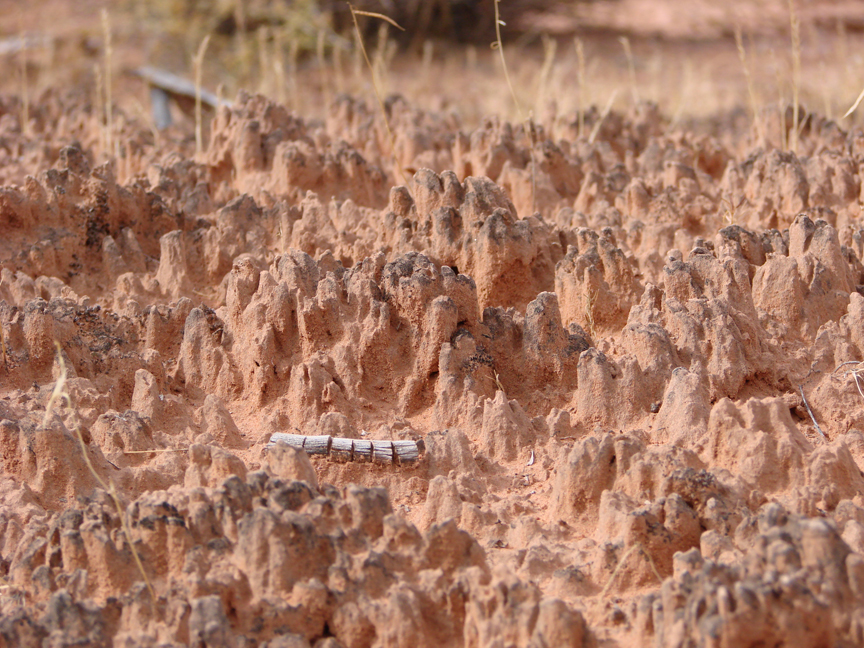
Cryptobiotic Soil Crust
Photo Courtesy & Copyright 2009
Mark Larese-Casanova

Cyanobacteria is also extremely useful to desert landscapes for its ability to take Nitrogen out of the air and make it available to plant roots in the soil. Desert soils typically have relatively low nutrients, so this is especially important to desert plants.

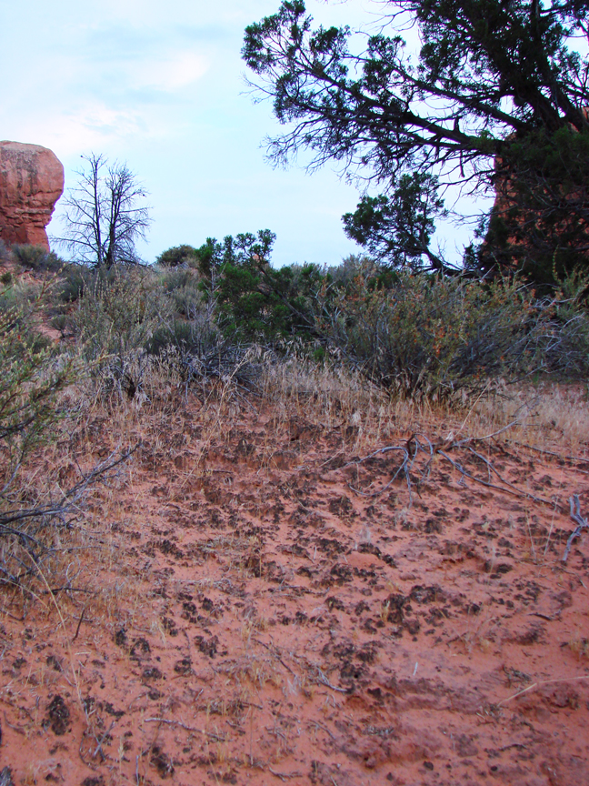
In many Utah deserts, cryptobiotic soil crusts can cover up to 70% of the ground surface. Old soil crust can often look like small mountain ranges with black or white peaks inhabited by lichens or mosses. The little valleys in between the tiny mountains of crust are perfect spots for the seeds of desert plants to grow. Over time, the above ground crust can grow up to ten centimeters, or four inches, thick!

However, cryptobiotic soil crust grows at an alarmingly slow rate of about one millimeter per year. So, any soil crust that is disturbed can take a very long time to recover. Depending on the amount of moisture a desert receives, it can take anywhere between 20 and 250 years for soil crust to grow back.

Next time you’re out in the desert, kneel down and have a close look at the telltale peaks and valleys of cryptobiotic soil crust. If you bring a magnifying glass, you just might be able to see some of the lichens and mosses. Be sure to stay on trail, though, and whatever you do, don’t bust that crust!

For Wild About Utah, I’m Mark Larese-Casanova.

Credits:

Images: Courtesy and copyright Mark Larese-Casanova
Text:     Mark Larese-Casanova, Utah Master Naturalist Program at Utah State University Extension.
Additional Reading:

US Department of Interior. 2001. Biological Soil Crusts: Ecology and Management. Bureau of Land Management Technical Reference 1730-2., https://www.blm.gov/nstc/library/pdf/CrustManual.pdf
Rosentreter, R., M. Bowker, and J. Belnap. 2007. A Field Guide to Biological Soil Crusts of Western U.S. Drylands. U.S. Government Printing Office, Denver, Colorado., https://www.soilcrust.org/
Oolites

Utah’s Oolitic Sand, Photo Courtesy and Copyright Mark Larese-Casanova

Hi, this is Mark Larese-Casanova from the Utah Master Naturalist Program at Utah State University Extension.

Imagine if prehistoric brine shrimp were responsible for one of the finest examples of architecture in Salt Lake City today.

Okay, so it may be a bit of a stretch, but let me explain. In a previous episode of Wild About Utah, I discussed the life cycle of brine shrimp and the important role that they play in the Great Salt Lake Ecosystem. Well, as the billions of brine shrimp feed on bacteria in Great Salt Lake, they excrete waste in the form of tiny fecal pellets. These pellets, along with sand grains and other bits of debris, eventually settle to the bottom of Great Salt Lake.

In shallow areas of the lake, where wind and waves routinely mix the water, these small particles gradually accumulate layers of calcium carbonate, forming an oolite (spelled o-o-l-i-t-e). This is very similar to how a pearl, also layers of calcium carbonate around a small particle, is formed within the shell of an oyster or mussel. The main difference, aside from a pearl being much larger, is that oolites are typically oblong, rather than round. The beaches on the west side of Antelope Island are a great place to find oolitic sand, which will look and feel as though you have a handful of tiny pearls.

Utah’s Oolitic Sandstone
Photo Courtesy & Copyright
Mark Larese-Casanova

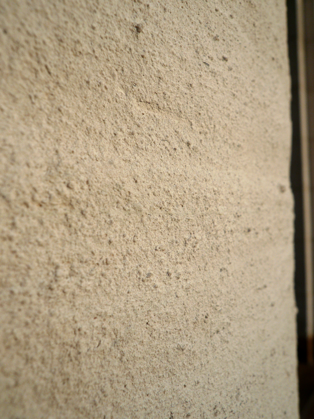
Around 50 million years ago, large fresh- and salt-water lakes covered parts of Utah, and in these areas, vast amounts of sediments, including oolites, were deposited. Over time, these oolites were compressed and cemented together into limestone.

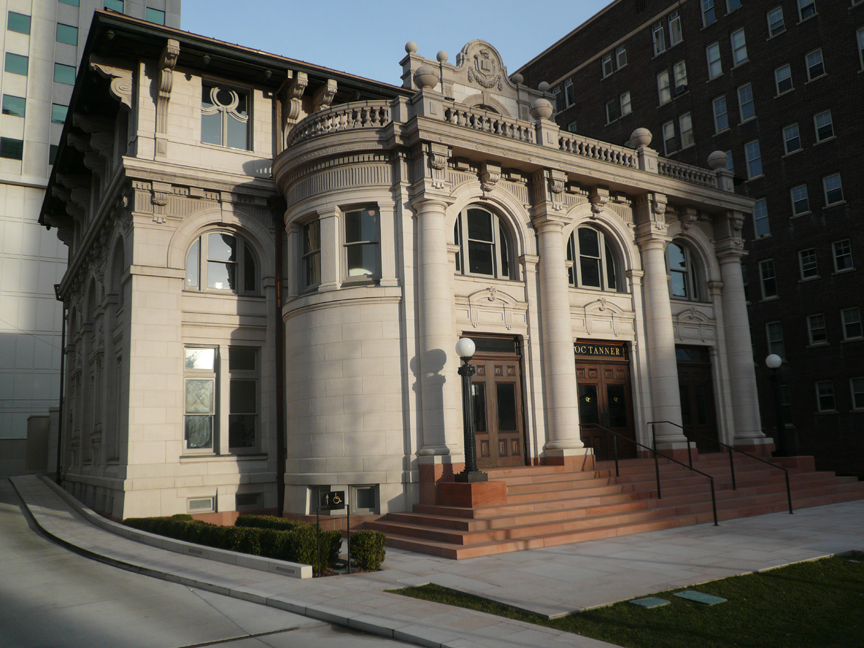
A quarry near Ephraim in Sanpete County supplied oolitic limestone for the construction of the Governor’s Mansion in 1902 and the original Salt Lake City Public Library in 1905. The Library building, located at 15 South State Street, eventually housed the Hansen Planetarium and is now home to the O.C. Tanner flagship store. The building underwent an extensive restoration just a couple of years ago, and now serves as a shining example of neoclassical architecture in our capitol city.

The truth is, there are tens of millions of years separating oolitic limestone from our modern-day brine shrimp. So, we can’t exactly say that prehistoric brine shrimp were responsible for the existence of the O.C. Tanner building. But, it’s fun to imagine precious gems from around the world housed in a beautiful building constructed from the ‘pearls’ of Great Salt Lake.

Historic OC Tanner Building
(formerly the Salt Lake Library
and later the Hansen Planetarium)
Photo Courtesy & Copyright
Mark Larese-Casanova

For Wild About Utah, I’m Mark Larese-Casanova.
Credits:

Images: Courtesy and copyright Mark Larese-Casanova

Text:     Mark Larese-Casanova, Utah Master Naturalist Program at Utah State University Extension.
Additional Reading:

Utah Geological Survey https://geology.utah.gov/utahgeo/rockmineral/collecting/oolitic.htm

Utah Division of Wildlife Resources, Great Salt Lake Ecosystem Program
https://wildlife.utah.gov/gsl/facts/oolitic_sand.php

Salt Lake Brine Shrimp, https://saltlakebrineshrimp.com/harvest/
 

The Dynamic History of Arches

The Dynamic History of Arches: Utah's Delicate Arch, Photo Courtesy and Copyright Mark Larese-Casanova
Utah’s Delicate Arch
Photo Courtesy & Copyright
Mark Larese-Casanova

Hi, this is Mark Larese-Casanova from the Utah Master Naturalist Program at Utah State University Extension.

The Dynamic History of Arches

A “bow-legged pair of petrified cowboy chaps” is how Edward Abbey once described Delicate Arch, that timeless example of Utah’s peculiar geology. In fact, it’s become such an icon that we see it on automobile license plates throughout the state. What we might not realize, though, is that there is nothing ‘timeless’ about Utah’s arches at all.

To help us understand this, let’s go back in time about 300 million years ago. At that time, inland seas routinely flowed into eastern Utah and evaporated, leaving behind a layer of salt that, in some places, is thousands of feet thick. During the next 200 million years, winds, oceans, and rivers deposited a rainbow of sediment layers in southern Utah. These sediments were eventually cemented into sandstones, limestones, and other sedimentary rocks.

Dynamic History of Arches: How nature builds an arch, Graphic Courtesy US National Parks Service
Click Graphic to
Learn How Nature Builds an Arch
Graphic Courtesy
US National Parks Service

Under the weight of all of these rock layers, along with the gradual uplift of the Colorado Plateau around 10 million years ago, the unstable salt layer below flowed like toothpaste. This caused the rock layers above to shift and buckle. Think of it as trying to build a brick house on top of a bed of mud- you would eventually have a house full of cracks.

In some areas, many parallel cracks formed at the surface, and as water flowed into these cracks, the sandstone eroded into tall vertical fins. Some of the fins collapsed over time, and some eroded in just the right way to form an arch. Arches continue to erode and will eventually collapse. But, at the same time, new arches will always form.

There are over 2,000 catalogued arches just within Arches National Park. That’s a lot of arches within such a small area! Within the park, most of the arches have formed in the red, iron-rich Entrada sandstone, however the tan Navajo sandstone also has several. Other rock formations to be seen include spires, mesas, windows, natural bridges, and balanced rocks.

To learn more about Utah’s amazing geologic history, visit Arches National Park’s website at nps.gov/arch or the Utah Geological Survey’s website at geology.utah.gov. And, make sure to visit and explore Utah’s arches as often as you can. After all, they won’t be around forever…

For Wild About Utah, I’m Mark Larese-Casanova.
Credits:

Images: Courtesy US National Parks Service

Delicate Arch, Courtesy & Copyright Mark Larese-Casanova

Text:     Mark Larese-Casanova, Utah Master Naturalist Program at Utah State University Extension.
Additional Reading:

Desert Solitaire, Edward Abbey, https://www.amazon.com/Desert-Solitaire-Edward-Abbey/dp/0671695886

Arches National Park, US National Park Service, US Department of the Interior, www.nps.gov/arch/

Utah Geological Survey, State of Utah, www.geology.utah.gov


The Sistine Chapel in Utah

The Sistine Chapel in Utah
Holy Ghost group, part of the
Great Gallery in Horseshoe Canyon
Photo Courtesy
David Sucec, BCSProject
(photographer, copyright holder)

Utah is famous for the beautiful and mysterious rock art found on its colorful canyon walls.

There are two main types of rock art. A petroglyph is an image that is pecked, incised, or scratched into rock. Petroglyphs are often found on rock surfaces coated with desert varnish. The dark stained varnish provides high contrast as the image is carved into the lighter underlying stone.

Pictographs, however, are painted onto rather than carved into a rock surface. Mineral pigments such as hematite, limonite, azurite, and gypsum were used to produce long lasting liquid and solid paints. Paint was applied with brushes, fingertips or hands, with fiber wads and even by spraying or blowing paint. It’s possible that vegetable dyes were also used by ancient artists but these would have been washed away without leaving a trace.

Archaeologists classify ancient rock art into different styles according to image content, drawing techniques, location, and the relationships between various picture elements. The so-called Barrier Canyon Style is well-known in eastern Utah where its greatest level of expression is found.

The Barrier Canyon Style features human-like figures with a supernatural appearance. Torso lengths are exaggerated and shaped like mummys or bottles. Heads may have horns, rabbitlike ears or antennalike projections. Eyes of the figures are often round and staring. Hands, if present, may be holding plant-like images or snakes. Aside from the human-like figures, birds, canines, bighorn sheep, and rabbits are also common in Barrier Canyon Style compositions.

Cultural affiliations of the Barrier Canyon Style artists are still not fully understood. But most archeaologists agree that the artists were part of small bands of nomadic people who roamed the Colorado Plateau between 7500 BC and 300 AD.

Perhaps the best place to view the Barrier Canyon style is in the Great Gallery in Horseshoe Canyon near Canyonlands National Park. The Great Gallery features a 300 feet long mural with over 60 figures. David Sucec (pronounced Soosek)–who is coordinating an effort to photograph and record all Barrier Canyon Style rock art–calls the Great Gallery ‘Utah’s Sistine Chapel.’

So far over 230 different sites featuring Barrier Canyon Style rock art have been discovered. In Utah, look for them in the Book Cliffs area, the San Rafael Swell, around Moab and in Canyonlands National Park.

Thanks to the Red Cliffs Lodge in Moab, Utah for supporting research and development of this Wild About Utah topic.

For Wild About Utah, I’m Holly Strand.

Credits:

Images: Courtesy & Copyright David Sucec
Text:     Holly Strand, Stokes Nature Center

Sources & Additional Reading:

BCSProject. https://www.bcsproject.org/about.html

Cole, Sally. 1990. Legacy on Stone: Rock Art of the Colorado Plateau and Four Corners Region. Boulder, CO: Johnson Printing

Repanshek, Kurt. Traces of a Lost People. 2005. Smithsonian magazine. March 2005. https://www.smithsonianmag.com/people-places/lost.html

Schaafsma, Polly. The Rock Art of Utah. 1971, Third Printing 1987, Papers of the Peabody Museum of Archaeology and Ethnology Vol. 65, paper, 169 pp. https://www.amazon.com/Rock-Art-Utah-Polly-Schaafsma/dp/0874804353

Take the Pledge to Protect the Past, Utah State Historical Preservation Office, Department of Cultural & Community Engagement, State of Utah, https://ushpo.utah.gov/shpo/upan/