Utah’s Petroglyph Garden

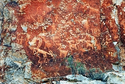
Petroglyph Panel at Fremont Indian State Park & Museum
Photo Courtesy Sevier County
Kreig Rasmussen, Photographer

Hi, I’m Ru Mahoney with Stokes Nature Center in Logan Canyon.

Utah’s culture is rich with vestiges of our pioneer history, and the landscape is accented by visible signs of the European settlers who forged our modern communities. But the tapestry of Utah’s cultural heritage is interwoven with much older threads, as indelible and enduring as the landscape itself.

In the 1980’s, in the southwestern quadrant of central Utah, the construction of interstate 70 unearthed a secret over one thousand years old. The valleys and canyons of what is now Sevier County, already known as a seasonal thoroughfare for the Paiute, had an even older history as home to the largest community of Fremont Indians ever discovered. Influenced by their Anasazi cousins to the southwest, the Fremont culture encompassed a diverse group of tribes that inhabited the western Colorado Plateau and the Great Basin area from roughly 400 to 1350 A.D. Archaeologists tell us they were a people of ingenuity in their engineering, aggression in their social interactions, and lasting creativity in their artistic expression. Divergent theories on their fate suggest they drove the Anasazi out of the Four Corners region and eventually migrated to further landscapes, or that northern groups of Fremont peoples joined with bands of Shoshone and became the Ute Indians of the Uinta. Whatever the truth of their ultimate fate may be, nowhere is their history more tangible than at Fremont Indian State Park just south of Sevier, UT along I-70. This year-round state park offers visitors a treasure trove of artifacts and curated exhibits in an excellent visitor’s center. But the most authentic interaction with these past peoples comes from exploring the surrounding landscape.

Driving the winding road into Clear Creek Canyon, ghostly figures begin to emerge; pictographs painted in shades of ocher and umber, and pale petroglyphs carved into the canyon walls, reveal an archaic and epic account of Utah’s ancestral past. A unique creation story, in which a shrike leads the Fremont people from a dark and cold underworld through the stem of reed into the warm world above, plays out across the canyon walls. A craggy outcrop of rock in the shape of an eagle is said to be watching over the reed to the underworld below to insure nothing wicked escapes into our world. A concentric lunar calendar and an abundance of zoomorphics speak of a cultural identity conceived in relation to the broader astrological world, and a reverence for anthropomorphized neighbors such as bighorn sheep and elk. Spider Woman Rock juxtaposes a powerful figure of Native American mythology with the pedestrian humility of a nursing mother. And Cave of 100 Hands is a visceral exhibition of a humanity simultaneously reminiscent and divergent from our own.

While the Fremont culture is believed to have died out or been absorbed by other modern groups, Clear Creek Canyon and the rock art sites of Fremont Indian State Park are significant among the modern Kanosh and Koosharem Bands of the Paiute who began using the area and leaving their own indelible marks on the canyon walls after the disappearance of the Fremont peoples around 1400 A.D. On the vernal and autumnal equinox (occurring in the third or fourth week of March and September each year) the eagle rock casts its shadow over the reed rock at dawn, breathing life into ancient tales of our ancestral history.

Fremont Indian State Park is a notable destination for those interested in rock art sites, many of which are suited to families of all ages and mobility, including visitors with strollers and wheelchairs. Stop in the visitor’s center to borrow or purchase a guide to the petroglyphs and pictographs for deeper insight into the Fremont culture and an unforgettable glimpse into Utah’s past.

For Wild About Utah and Stokes Nature Center, I’m Ru Mahoney.

Credits:
Images: Courtesy Sevier County, Kreig Rasmussen, Photographer
Text:     Ru Mahoney, Stokes Nature Center in Logan Canyon.


Additional Reading:

https://stateparks.utah.gov/parks/fremont-indian/

https://stateparks.utah.gov/stateparks/wp-content/uploads/sites/26/2015/02/Fremont_IndianBrochure.pdf

https://www.nps.gov/grba/learn/historyculture/fremont-indians.htm

https://www.thefurtrapper.com/fremont_indians.htm

Take the Pledge to Protect the Past, Utah State Historical Preservation Office, Department of Cultural & Community Engagement, State of Utah, https://ushpo.utah.gov/shpo/upan/
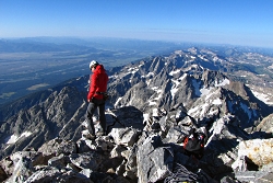
Climb Grand Teton…Virtually

Grand Teton virtual climb

Click to view larger image of Grand Teton virtual climb, Photo Courtesy NPS Photo Courtesy NPS, K Kanes, Photographer
.

Photo Courtesy NPS
K Kanes, Photographer
 
Begin Tour
(Requires Adobe Flash Player)

Scaling “the Grand,” that picturesque mountain that hangs over Jackson, Wyoming, along with its battleship-gray sisters in the Teton Range, was a ridiculous thought that found harbor in the back of my mind in the spring of 1985 when I first glanced up at the peak.

Along with a dozen or so other neighboring peaks that rise above 10,000 feet, the Tetons form a ponderous, jagged stretch of rock that is the Lower 48’s most arresting mountain range. The soul of Grand Teton National Park, the Grand as it’s known harbors world-class climbs.

Some climbers tackle the mountain on their own, while neophytes such as myself are herded ever upward under the watchful guidance of one of Jackson’s two resident climbing outfitters, Exum Mountain Guides and Jackson Hole Mountain Guides.

To me, an Easterner by birth, the 13,770-foot tall Grand Teton is a breathtaking, and incredibly tall, mountain. But climb it? Not only am I usually most comfortable with both feet firmly planted flat on the ground, but the thought of only a thin rope and a precarious hand- or toe-hold between me and an incredible long way down scared the hell out of me, quite frankly.

The view from atop the Grand Teton is incredible. To the west, the Jedediah Smith Wilderness stands. To the north, Yellowstone National Park. To the east, Jackson Hole, with the moraine that is Timbered Island so very well defined.

Now, if you haven’t climbed to the roof of Grand Teton National Park, or can’t, you can still enjoy the view.

A new virtual tour produced by the park staff takes you from the Jackson Hole Valley to the summit from the comfort of your living room or office. No cold or pelting rain, no thunder claps or lightning strikes, just a nice mix of interactive still photos and video cuts that take you to the top.

This virtual mountaineering excursion—or eClimb, as the park dubs it—provides an introduction to the features, geology, history, and excitement of scaling the granite ledges and spires that form the Grand Teton massif: the highest peak in the Teton Range and second highest mountain in Wyoming. This web-based tour introduces viewers to the various elements (rocky terrain, plants and wildlife) that exist in Grand Teton’s forest and alpine communities.

As an eClimber you can control images and sounds at each stop along your virtual tour, and you can activate videos to explore the human and natural history related to each location along the climbing route. By hovering your mouse over a photograph, hidden images will be revealed through the click of a button.

eClimbers can also use videos to imagine scrambling over boulder fields and wedging through rocky alcoves as they experience the thrill of climbing and drama of a mountain rescue in a virtual landscape.

To find this virtual climb, go to Grand Teton’s website (www.nps.gov/grte) and click on  “Grand Teton eClimb” near the bottom of the home page.

For Wild About Utah, this is Kurt Repanshek with National Parks Traveler

Credits:
Image: Courtesy USGS, www.usgs.gov
Image: Courtesy and Copyright Kurt Repanshek, www.nationalparkstraveler.com
Text:     Kurt Repanshek, NationalParksTraveler.com.

 
Additional Reading:

Grand Teton National Park

Grand Teton eClimb

NationalParksTraveler.com

National Parks Traveler: Climb The Grand Teton…Virtually!


Golden Spike Locomotive Refurb.

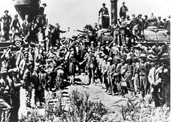
Driving the golden spike ceremony at Promontory Summit, Utah on May 10, 1869, Courtesy of the US National Park Service
Driving the golden spike ceremony at Promontory Summit, Utah on May 10, 1869
Courtesy of the US National Park Service
 
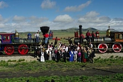
Reinactment of the golden spike ceremony at Promontory Summit, Utah on May 10, 2014, Utah. Photo Courtesy US NPSReinactment of the golden spike ceremony at Promontory Summit, Utah on May 10, 2014
Courtesy of the US National Park Service
 
Box Elder County, Utah. Photo Courtesy US NPSSteve Sawyer
National Park Service Locomotive Engineer
Photo Courtesy and Copyright Pat Cone
 
Fireman Michael Ostereich. Photo Courtesy and Copyright Pat ConeFireman Michael Ostereich
Photo Courtesy and Copyright Pat Cone


This sage-covered valley is not on the way to anywhere, unless you’re a railroad and history fan. For it was here, on that May 10th, 146 years ago, that a grand undertaking came to its celebratory conclusion: the meeting of the rails and two grand locomotives.

With the driving of the Golden Spike the Central Pacific, that had clawed its way across the High Sierra and vastness of the Nevada Desert, and the Union Pacific, which rolled across the plains and Rocky Mountains completed a steel artery of commerce and transportation.

Union Pacific Number 119 and the Central Pacific Number 60 (better known at Jupiter) faced each other amidst a crowd of dignitaries, engineers, and railroad workers as the final rails were laid, and spikes were driven. President Abraham Lincoln’s dream of a transcontinental railroad was complete.

Today, the Golden Spike National Historic Site at Promontory, Utah commemorates this event, staging daily reenactments of this meeting with two, grand replica engines. And this May 10th, they’ll look and run better than ever after having undergone a thorough refurbishing.
The original engines were scrapped for their metal in the early 1900s. These two massive replicas were built in 1979 at a cost of nearly $750,000 a piece, in Costa Mesa, California, by Chad O’Connor. He had a passion for steam.

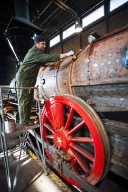
Every 15 years these locomotives are disassembled, boilers cleaned and tested, and over 166 fire tubes replaced. The boiler is pressure tested, the gauges and brass bells and whistles are brightly shined, and the funneled smokestack is repainted, ready for their big day. There’s over 500 feet of tubing in each engine, they weigh 62 tons apiece, and make steam from treated water the old fashioned way: 119 burns coal, and the Jupiter is wood-fired.

Steve Sawyer has been a National Park Service locomotive engineer for 8 years and loves driving these down the track, wearing period costume. He’s one of two engineers, and a fireman who fires them up and takes them out. “These engines run 8 hours a day for 5 months from May 1st through October 15th,” he says, so they need a thorough rebuilding.

Fireman Michael Ostereich takes his time as he puts a rust-proof sealant around the new welds on the boiler, in preparation for a layer of insulation, and the final jacket. But the three railroadmen aren’t alone. There are over 60 volunteers that help in this grand task, reminding us of what it meant to be able to travel from coast to coast in style and comfort.

Jupiter is red and blue, while Number 119 is mostly red with black. Jupiter has a bright blue cowcatcher and a large funnel, while Number 119’s cowcatcher is red with a straight smokestack. The drive wheels are as tall as most men and the pistons are shined to a mirror finish, and there are hand-painted scenes adorning them from Disney animator Ward Kimball.

They are huge, noisy, and magnificent works of art. And, they’ll both be ready for their debut during the anniversary of the meeting of the rails on May 10th. There will be kids of all ages there, so catch them in action if you can.

For Wild About Utah, this is Patrick Cone with National Parks Traveler

Credits:
Image: Courtesy US National Parks Service, www.nps.gov
Image: Courtesy and Copyright Patrick Cone, www.nationalparkstraveler.com
Text:     Patrick Cone, NationalParksTraveler.com.

Additional Reading:

Golden Spike National Historic Site, Brigham City, Utah, Golden Spike National Monument, US NPS, https://www.nps.gov/nr/Travel/cultural_diversity/Golden_Spike_National_Historic_Site.html

Golden Spike National Monument, US NPS, https://www.nps.gov/gosp/index.htm

Golden Spike Locomotives Being Refurbished, Patrick Cone, National Parks Traveler, https://www.nationalparkstraveler.com/2015/03/golden-spike-locomotives-being-refurbished26421

Blowing Off Steam…, National Parks Traveler, https://www.nationalparkstraveler.com/potw/blowing-steam22551

An Arizona Road Trip Back Into the Past

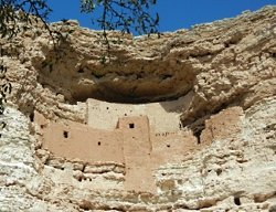
Montezuma Castle, Courtesy US NPS
Montezuma Castle
Courtesy US NPS
 
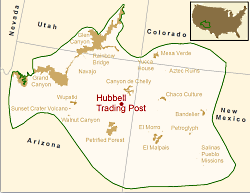
Location of Hubbell Trading Post NHS in the Southern Colorado Plateau Network,  Courtesy US NPSLocation of Hubbell Trading Post NHS in the Southern Colorado Plateau Network
Courtesy US NPS
 
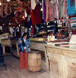
Hubbell Trading Post, Courtesy US NPSHubbell Trading Post Interior
Courtesy US NPS

Arizona is rich in history — from the 1800s all the way back to the Late Triassic Period. You can stitch together a road trip that winds out of Flagstaff to Montezuma Castle National Monument, to Petrified Forest National Park, and ends at Hubbell Trading Post National Historic Site. Along the way you’ll experience fascinating chapters of geologic and cultural history.

At Montezuma Castle, 45 minutes south of Flagstaff and just off Interstate 17 (Exit 289), a short walk places you in front of a 5-story-tall cliff dwelling that offered safety from invaders: it stands 100 feet above the valley floor, nestled into an alcove.

The site was misnamed Montezuma Castle in the late 1800s by whites who thought the structure had been built by the Aztec people. The original owners, members of the Southern Sinagua (seen aug wah) people, called this area home from roughly 1100-1425 A.D.

Stroll the short trail that loops around a vegetated landscape below the “castle,” and you’ll find great views as well of the remains of Castle A. That dwelling once rose 60 feet and was home to about 100 residents.

From Montezuma’s Castle, it’s 95 miles via Arizona 87 to Winslow, and then 34 miles east on Interstate 40 to Holbrook. Finally, another 19 miles southeast on Arizona 180 leads you into Petrified Forest National Park and its unusual landscape.

There’s no lodging within the park, and you have to leave by sundown, so you will need to make some tough decisions if you have just one day. Do you take time to tour the Rainbow Forest Museum with its dinosaur displays, or hike out to Agate House?

A building built of petrified wood is pretty cool, so stretch your legs with a walk to the house. Then head north and deeper into the park to the Crystal Forest Trail. Wander this path and you’ll find yourself surrounded by petrified wood with its hues of yellow, red, and green, black and white.

Blue Mesa is another great stop. There’s a trail that takes you down into another colorful landscape of badlands and chunks, logs, and even slabs of petrified wood in shades of red, blue, yellow and black.

The northern end of the park road is anchored by the Painted Desert, a great place for sunset photos. Here you’ll also see the Painted Desert Inn, which some day could put the Park Service back into the lodging business but today is just a museum piece.

Back on Interstate 40, drive 22 miles east to Chambers, and then north on U.S. 191 for about 38 miles to Ganado and Hubbell Trading Post. This authentic trading post was opened by John Lorenzo Hubbell in 1878 on the Navajo Reservation.

Although it was added to the National Park System in 1967, Hubbell is not a museum piece but an active trading post. As such, it still holds richly woven Navajo rugs, jewelry, and other Native American artworks for purchase.

Schedule your visit to Hubbell Trading Post for May and you just might be able to attend the annual Native American Art Auction. Check with the park (928-755-3475) for the exact date.

If you have a little more free time, you could extend your your trip by heading 39 miles north on 191 to Canyon de Chelly National Monument.

For Wild About Utah and National Parks Traveler, I’m Kurt Repanshek.

Credits:
Image: Courtesy and Copyright Kurt Repanshek, www.nationalparkstraveler.com
Text:     Kurt Repanshek, NationalParksTraveler.com.


Additional Reading:

Montezuma Castle National Monument, NationalParksTraveler.com, https://www.nationalparkstraveler.com/2012/03/visiting-montezuma-castle-national-monument-arizona9636

Montezuma Castle National Monument, US National Park Service, https://www.nps.gov/moca/index.htm

Geographic Area covered by the State of Deseret and Utah Territory, International Society Daughters of Utah Pioneers, https://www.dupinternational.org/dyn_page.php?pageID=54