Wetlands-What’s in a name?

Wetlands- What’s in a name?
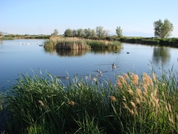
Wetlands- What’s in a name? Pond and marsh showing wetland plants with Canada geese goslings and pelicans. Photo Courtesy and Copyright Mark Larese-Casanova
Pond and marsh showing
wetland plants with
Canada geese goslings and pelicans.
Courtesy & Copyright ©
Mark Larese-Casanova
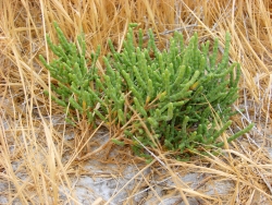
Wetlands- What’s in a name? Pickleweed growing in a salt playa is adapted to growing in saline soils. Photo Courtesy and Copyright Mark Larese-Casanova
Pickleweed growing in a salt playa
is adapted to growing in saline soils.
Courtesy & Copyright ©
Mark Larese-Casanova

Hi, this is Mark Larese-Casanova from the Utah Master Naturalist Program at Utah State University Extension.Wetlands- What’s in a name?

A wetland really is more than just ‘land that is wet’. There are certain key ingredients that need to go into a wetland for it to truly be a wetland. Of course, water needs to be present for at least part of the growing season. It can simply be in the form of temporarily saturated soils or even standing water a few feet deep.

As soil becomes saturated with water, oxygen levels are greatly reduced. Quite often, bacteria in saturated soils will create hydrogen sulfide, giving wetland soils that stinky odor of rotten eggs. As plants grow in a wetland over several years, their decaying matter helps to create a thick, dark layer of organic soil.

The presence of water in a wetland encourages the growth of hydrophytes, or ‘water-loving’ plants, that are specially adapted to living in wet environments. Many wetland plants have open spaces within the leaves and stems- often referred to as aerenchyma. This allows oxygen to diffuse down to the roots, sometimes creating an oxygen-rich environment in the soil around a plant. Also, many wetland plants reproduce both by floating or wind-dispersed seeds and by rhizomes, which are underground roots that can travel great distances. Some plants that grow in salty wetlands around the Great Salt Lake are able to control the salt in their tissues by depositing it on the outside of the leaf or containing it in chambers within their cells.

Like plants, specially adapted animals also call wetlands their home. Mammals and birds have oily fur or feathers that allow them to swim in cold water without losing much body heat. They also often have webbed feet to aid in swimming. Other animals, such as fish, amphibians, and insects, have gills to breathe in water.

Despite being the second driest state in the country, Utah has a high diversity of wetlands. Vast marshes surround the Great Salt Lake, providing habitat to enormous populations of migratory birds. Less obvious wet meadows provide unique habitat to butterflies and other insects. Salty playas, which are shallow basins with no outlet, are found throughout the West Desert, creating unique ecosystems of highly adapted plants. Riparian wetlands can grow along the edges of rivers, providing a unique transition between the swift water and upland habitats. Southern Utah is home to some peculiar wetlands such as potholes and hanging gardens, both associated with sandstone bedrock. A hanging garden clings to the side of a moist cliff, creating a microhabitat for rare plants, such as orchids and monkeyflower. Potholes can simply be eroded basins in the sandstone where water collects in spring. A pothole is an oasis that provides water for desert wildlife and a home for fairy shrimp and spadefoot toads.

Spring is the perfect time of year to visit a wetland. The constant chorus of birds, insects and amphibians are a testament to the importance of wetlands, teeming with life in the middle of a desert.

For Wild About Utah, I’m Mark Larese-Casanova.

Credits:

Images: Courtesy & Copyright © Mark Larese-Casanova

Text:     Mark Larese-Casanova, Utah Master Naturalist Program at Utah State University Extension.
Additional Reading:

Mitsch, W.J., and J.W. Gosselink. (1993). Wetlands. Van Nostrand Rheinhold.

Tiner, R. W. (1999). Wetland Indicators: A Guide to Wetland Identification, Delineation, Classification, and Mapping. CRC Press

Utah Division of Wildlife Resources. (1995). Playas to Marshes…Where Water Meets Land. Growing WILD Newsletter. https://www.wildlife.utah.gov/education/newsletters/95spring-gw.pdf

Utah Division of Wildlife Resources. (2003). Utah’s Wonderful Wetlands Activity Guide. https://wildlife.utah.gov/education/pdf/wetlands_activity_guide.pdf
Wetlands- What’s in a name?
Wilderness, Much Closer Than You Think

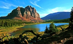
Wilderness, Much Closer Than You Think: Courtesy Wilderness.net and Copyright 2009 Cordell Andersen, Photographer
High Unitas Wilderness, Utah
Courtesy Wilderness.net
Copyright © 2009 Cordell Andersen, Photographer

Wilderness, Much Closer Than You Think: Courtesy Wilderness.net and Copyright 2011 Paul Gooch, PhotographerRed Butte Wilderness, Utah
Courtesy
Wilderness.net
Copyright © 2011 Paul Gooch, Photographer

Courtesy Wilderness.net and Copyright 2011 Dusty Vaughn, PhotographerWellsville Mountain Wilderness, Utah
Courtesy Wilderness.net
Copyright © 2011 Dusty Vaughn, Photographer

Courtesy Wilderness.net and Copyright 2011 Mike Salamacha, BLM, PhotographerParia Canyon
Vermilion Cliffs Wilderness
Courtesy Wilderness.net
Copyright © 2011 Mike Salamacha, Paria Ranger, BLM, Photographer


The word conjures up romantic images of wide open landscapes teeming with birds, beasts, and plants. I imagine places untouched by human influence – truly wild and free. Places that are exotic and far away.

But wilderness exists much closer than you may think.

The United States Congress adopted the Wilderness Act with a nearly unanimous vote in 1964. Ours was the first country in the world to define and designate wilderness areas – lands valued enough to be set aside for the purpose of protection.

Currently, the Wilderness Act protects 757 individual wilderness areas across the United States – totaling more than 109 million acres. Thirty-three wilderness areas are found in Utah, and they protect a variety of unique landscapes from the red rock desert found in Red Butte Wilderness to the alpine forests of the High Uintas Wilderness. While the landscapes may look incredibly different from one wilderness area to the next, these lands share a number of qualities which can be described by adjectives such as peaceful, quiet, untouched, and pristine.

These areas protect some of the most unique and incredible landscapes that Utah has to offer, but that doesn’t mean they’re off limits. Our wilderness areas are just that – ours. They are public lands, accessible to anyone who wants to visit – so long as you tread lightly.

Areas that fall under its protection are described in the Wilderness Act as “lands designated for preservation and protection in their natural condition…” which “…shall be devoted to the public purposes of recreation, scenic, scientific, educational, conservation and historic use.” These amazing lands were set aside in 1964 with an eye to the future and because of it, should still be around for your grandchildren’s grandchildren to enjoy.

There is an ongoing effort to educate Americans about the immense value of preserving wilderness areas. For without education, they may one day be selfishly reclaimed and lost. One of these educational opportunities is coming to Logan on April 13th and 14th. The Arthur Carhart National Wilderness Training Center will be hosting a teacher training workshop in conjunction with the Stokes Nature Center and the Utah Society for Environmental Education. The workshop is aimed at teachers in grades 5-8, though anyone is welcome to attend. For more information, please contact the Stokes Nature Center at www.logannature.org

Not a teacher? The best way to learn about wilderness areas is to go visit one! Information, and photos of Utah Wilderness Areas, can be found at www.wildaboututah.org

For the Stokes Nature Center and Wild About Utah, this is Andrea Liberatore.

Credits:

Photos: Courtesy Wilderness.net, Steve Archibald, (Individual Copyrights noted)
Text:    Andrea Liberatore, Stokes Nature Center, logannature.org

Additional Reading:
The Arthur Carhart National Wilderness Training Center:
wilderness.net

Wilderness Investigations teacher training workshop:
logannature.org/wi_workshop

Public Law 88-577 a.k.a. Wilderness Act, Sept 3, 1964, U.S. Government Publishing Office: https://www.govinfo.gov/content/pkg/STATUTE-78/pdf/STATUTE-78-Pg890.pdf

Cryptobiotic Soil Crusts

Cryptobiotic Soil Crust
Photo Courtesy & Copyright 2009
Mark Larese-Casanova

Hi, this is Mark Larese-Casanova from the Utah Master Naturalist Program at Utah State University Extension.

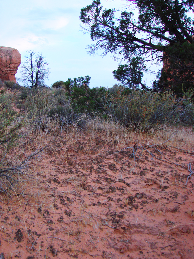
Looking out over a Utah desert, we might see relatively few plants- perhaps some sagebrush, maybe a few junipers or Joshua trees, or even some small wildflowers or cacti. What is less noticeable, though, is the living soil crust that holds this entire landscape together. It’s not just sand, but rather an important and vast partnership between bacteria, lichens, algae, and fungi. These soil crusts are often referred to as ‘cryptobiotic’, which means ‘living in suspended animation’. This is a fitting description, considering that water can be so rare in Utah’s deserts.

Cyanobacteria, which is often called blue-green algae, is the backbone of cryptobiotic soil crust. Vast networks of long, microscopic filaments of cyanobacteria and fungi grow in length when they are wet, and leave behind a casing that literally binds the soil together. So, what might otherwise be loose sand not only is less likely to be washed away by water or blown away by wind, but also is able to hold much more water for plants.

Cryptobiotic Soil Crust
Photo Courtesy & Copyright 2009
Mark Larese-Casanova

Cyanobacteria is also extremely useful to desert landscapes for its ability to take Nitrogen out of the air and make it available to plant roots in the soil. Desert soils typically have relatively low nutrients, so this is especially important to desert plants.

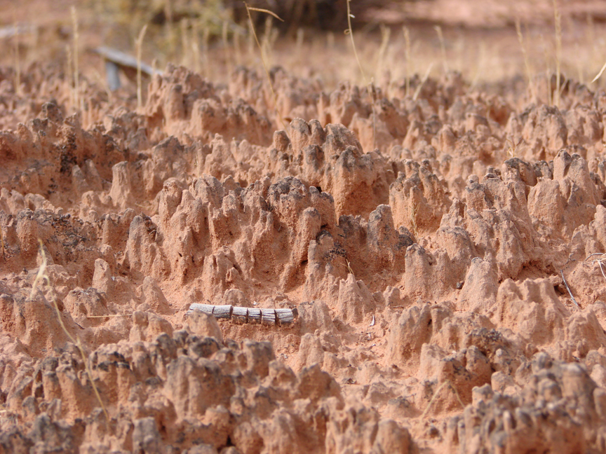
In many Utah deserts, cryptobiotic soil crusts can cover up to 70% of the ground surface. Old soil crust can often look like small mountain ranges with black or white peaks inhabited by lichens or mosses. The little valleys in between the tiny mountains of crust are perfect spots for the seeds of desert plants to grow. Over time, the above ground crust can grow up to ten centimeters, or four inches, thick!

However, cryptobiotic soil crust grows at an alarmingly slow rate of about one millimeter per year. So, any soil crust that is disturbed can take a very long time to recover. Depending on the amount of moisture a desert receives, it can take anywhere between 20 and 250 years for soil crust to grow back.

Next time you’re out in the desert, kneel down and have a close look at the telltale peaks and valleys of cryptobiotic soil crust. If you bring a magnifying glass, you just might be able to see some of the lichens and mosses. Be sure to stay on trail, though, and whatever you do, don’t bust that crust!

For Wild About Utah, I’m Mark Larese-Casanova.

Credits:

Images: Courtesy and copyright Mark Larese-Casanova
Text:     Mark Larese-Casanova, Utah Master Naturalist Program at Utah State University Extension.
Additional Reading:

US Department of Interior. 2001. Biological Soil Crusts: Ecology and Management. Bureau of Land Management Technical Reference 1730-2., https://www.blm.gov/nstc/library/pdf/CrustManual.pdf
Rosentreter, R., M. Bowker, and J. Belnap. 2007. A Field Guide to Biological Soil Crusts of Western U.S. Drylands. U.S. Government Printing Office, Denver, Colorado., https://www.soilcrust.org/

Colorado vs. Utah Snow

Utah snow in author's backyard: relatively light and dry--and definitely deep, Photo Copyright 2010 Holly Strand
Utah snow in author’s backyard:
relatively light and dry
–and definitely deep.
Copyright © 2010 Holly Strand

Hi I’m Holly Strand.

Growing up in Colorado, it never crossed my mind that the snow might be better somewhere else. I believed that my state was the center of the universe– at least as far as snow and skiing were concerned. A couple of decades passed and now I am a Utah resident. I couldn’t help but notice that snow quality here is well beyond satisfactory. And many Utah license plates claim the Greatest Snow on Earth. So, I wondered… Who has better snow? Colorado or Utah?

People usually assume that “great snow” means voluminous and powdery. So let’s compare the 2 states using measures of snow depth for volume and measures of water content for powder.

As far as snow depth, Alta takes the cake and wins mega points for Utah. According to data collected by ski area avalanche professionals, Alta’s average annual snowfall from Nov 1-Apr 30 is 530 inches. That’s 44 feet of snow ! A few other Utah resorts,–plus Colorado’s Wolf Creek Pass–come next with 400 + inches. After that, you get several 300+ inches resorts in both states. More in Colorado, but that’s just because there are more resorts in general. Colorado also has a bunch of areas with 200+ inches. But the point is that a handful of super-snowy resorts lead the pack and most of them are in Utah.

Next I located National Weather Service data for the average water content of freshly fallen snow. The lower the value, the drier the snow. It turns out that the mean water content of new snow decreases as you move eastward from the Pacific Coast to the Rockies. You get values around 12 % water content for the Sierras. This is the infamous Sierra Cement. Intermountain (including the Wasatch Mountains) values hover around 8.5%. The mean water content value for Central Rocky Mountain stations was close to 7%. So in general, Colorado has less watery snow. Of course there are localized anomalies in each state. But overall, Colorado appears to edge out Utah for light, dry, and fluffy snow.

So who has the best snow overall? Well, I guess I still haven’t solved that issue. Best to discuss it further after an exhilarating day on the slopes. Let us know what you think: Send us an email at wildaboututah@gmail.org

For data sources and archives of past Wild About Utah episodes visit www.wildaboututah.org

For Wild About Utah, I’m Holly Strand.

Credits:

Photos: Courtesy and Copyright 2010 Holly Strand

Text: Holly Strand

Sources & Additional Reading:

Armstrong, R.L. and B.R. Armstrong. 1987. Snow and avalancheclimates of the western United States: a comparison of maritime, intermountain and continental conditions. IAHS Publ. 162
(Symposium at Davos 1986 – Avalanche Formation, Movement and Effects), 281–294

Baxter, M.A., C.E. Graves, and J.T. Moore, 2005: A Climatology of Snow to Liquid Ratio for the Contiguous United States, Weather and Forecasting, 20, 729-744.

Crocker, Tony. BESTSNOW.NET – an independent statistical analysis of snow characteristics (based on data collected by ski area avalanche professionals) at major North American ski resorts. https://webpages.charter.net/tcrocker818/ [accessed December 14, 2010]

Steenburgh, W. J., and T. I. Alcott, 2008. Secrets of the “Greatest Snow on Earth.” Bull. Amer. Meteor. Soc., 89, 1285-1293.