Naturally Carbonated Water

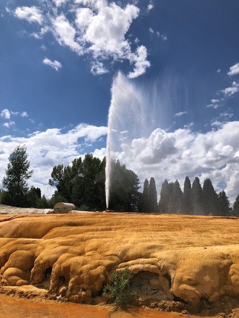
Naturally Carbonated Water: Soda Springs Geyser, Soda Springs, Idaho, Courtesy & &copy Mary Heers, Photographer
Soda Springs Geyser, Soda Springs, Idaho

If you like drinking carbonated water as much as I do, you’ll be happy to hear you can drink as much as you’d like, -absolutely for free- just north of the Utah border in Soda Springs, Idaho.
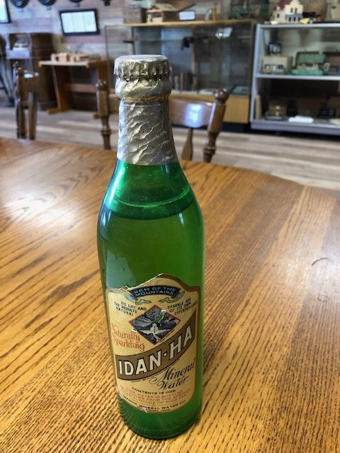
Idan-Ha Mineral Water, Courtesy & &copy Mary Heers, Photographer
Idan-Ha Mineral Water
Courtesy & &copy Mary Heers, Photographer

Small Bubbling Soda Water Pool, Courtesy & &copy Mary Heers, Photographer Small Bubbling Soda Water Pool
Courtesy & &copy Mary Heers, Photographer

When settlers heading to California passed through this area on the Oregon Trail, they saw the many bubbling natural springs.

In 1838 Sarah White Smith, wrote in her diary, This is indeed a curiosity. The water is bubbling and foaming like boiling water.” But the water wasn’t hot.

She also wrote how delighted she was when she made bread with the water. “The bread was as light as any prepared with yeast.”

All this stirred up some fond memories I have of my high school science teacher who always made interesting things happen in the classroom. She put a pinch of sodium bicarbonate (commonly called baking soda) in a dish and added a couple tablespoons of water and vinegar. Voila! The dish began “bubbling and foaming like boiling water.”

For centuries something like this has been going on under the ground in Soda Springs. The carbonate rocks are mixing with slightly acidic water, sending CO2 bubbles to the surface .

By 1887, Soda Springs had grown to a bustling town. Some enterprising residents came up with a plan to capture the CO2 gas. They built giant drums over one of the springs and then built a five-mile pipeline to their bottling plant. There they mixed the gas with clear water from another spring and bottled it. The soda water was called “Idan-ha” and was shipped out on the railroad far and wide.

It won first place at the Chicago World’s Fair in 1893 and again in the World’s Fair in Paris in 1905.

A decade later, another group of businessmen went to work on a plan to build a mineral water swimming pool resort.

On Dec 2, 1937, drillers dug down to 315 ft. No luck. They went to dinner. Then they heard a gush of water shoot up outside the window. They said it was “roaring like a dragon.” The whole area was enveloped in water vapor and Main Street was flooded. It took them two weeks to cap it.

The water wasn’t warm, so the businessmen abandoned their plans for a swimming pool resort.

The town knew their geyser was accidental; it was man-made- but still a plume of water shooting 100 ft into the air was impressive to look at.

Engineers put a timer on the cap. Now the carbonated water shoots up for 8 minutes every hour on the hour.

You can watch it for free.

As for drinking the naturally carbonated water, the city has set aside three springs.

My guide drove me to his favorite site just outside of town We scrambled down a grassy hillside to a small bubbling pool about the size of a basketball. He whipped out a cup and dipped it in. I drank. It was cold and fizzy.

“Good as Perrier,” I said.

He smiled, “Now I like you.”

I liked him too. Even more, I loved drinking this tasty treasure bubbling up from the ground.

This is Mary Heers and I’m Wild About Utah

Credits:

Photos:
Images Courtesy & Copyright Mary Heers, Photographer
Featured Audio: Courtesy & Copyright © Friend Weller, Utah Public Radio upr.org
Text: Mary Heers, https://cca.usu.edu/files/awards/art-and-mary-heers-citation.pdf
Additional Reading: Lyle Bingham, https://bridgerlandaudubon.org/

Additional Reading

Wild About Utah, Mary Heers’ Postings

Price, Mike, Soda Springs, We Are East Idaho, EastIdahoNews.com LLC, September 9, 2019, https://www.eastidahonews.com/2019/09/we-are-east-idaho-soda-springs/

Hooper Springs Park, California National Historic Trail, Oregon National Historic Trail, National Park Service, US Department of the Interior, https://www.nps.gov/places/000/hooper-springs-park.htm

A man-made CO2 Geyser in Utah:
Weaver, Lance, Crystal Geyser, Grand County, Utah, Geosights, Utah Geological Survey (UGS), Utah Department of Natural Resources, January 2018, https://geology.utah.gov/map-pub/survey-notes/geosights/crystal-geyser/

Map on page 43 shows water from Soda Springs flows into the Bear River and the Great Salt Lake:
Dissolved-Mineral Inflow to Great Salt Lake and Chemical Characteristics of the Salt Lake Brine, United States Geological Survey (USGS) and The College of Mines and Mineral Industries, The University of Utah, 1963, https://ugspub.nr.utah.gov/publications/open_file_reports/ofr-485/Lake%20Brine%20Interpretive%20Reports/WRB%2003%20-%20Part%201%20-%20Hahl%20&%20Mitchell%20-%201963/Water%20Resources%20Bulletin%203%20Pt%201%201963.pdf

Bear Lake Limestone

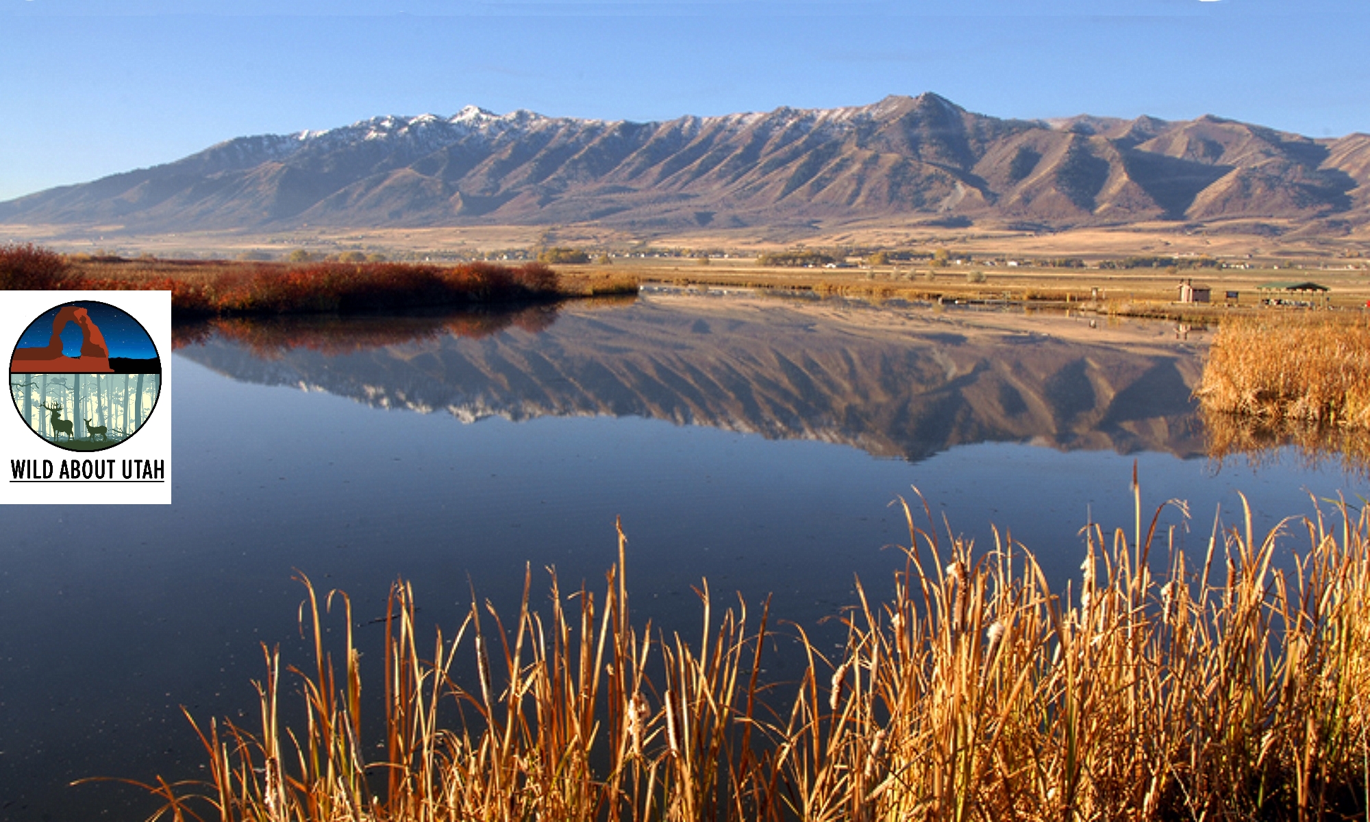
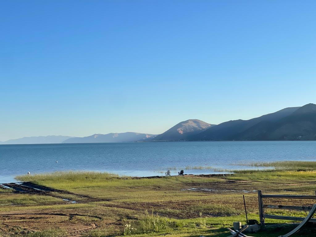
Bear Lake Limestone: Pale Blue Bear Lake from the Shore, Courtesy & Copyright Mary Heers, Photographer
Pale Blue Bear Lake from the Shore
Courtesy & Copyright Mary Heers, Photographer

Blue Sky Reflected on the Water of Bear Lake, Courtesy & Copyright Mary Heers, Photographer Blue Sky Reflected on the Water of Bear Lake
Courtesy & Copyright Mary Heers, Photographer

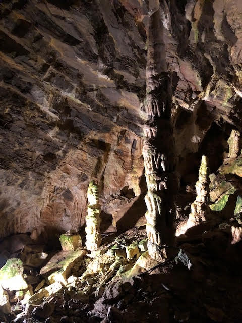
Stalagmites in Minnetonka Cave, St Charles Canyon, West of Bear Lake, Courtesy & Copyright Mary Heers, Photographer Stalagmites in Minnetonka Cave, St Charles Canyon, West of Bear Lake
Courtesy & Copyright Mary Heers, Photographer

Soda Straw Stalactites in Minnetonka Cave, St Charles Canyon, West of Bear Lake, Courtesy & Copyright Mary Heers, Photographer Soda Straw Stalactites in Minnetonka Cave, St Charles Canyon, West of Bear Lake
Courtesy & Copyright Mary Heers, Photographer

Small Ribbon  Stalactites in Minnetonka Cave, St Charles Canyon, West of Bear Lake, Courtesy & Copyright Mary Heers, Photographer Small Ribbon Stalactites in Minnetonka Cave, St Charles Canyon, West of Bear Lake
Courtesy & Copyright Mary Heers, Photographer

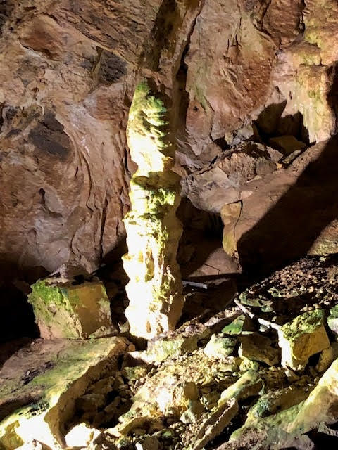
Stalagmite in Minnetonka Cave, St Charles Canyon, West of Bear Lake, Courtesy & Copyright Mary Heers, Photographer Stalagmite in Minnetonka Cave, St Charles Canyon, West of Bear Lake
Courtesy & Copyright Mary Heers, Photographer

If you stop at the overlook above Bear Lake on a sunny summer day, you may be as surprised as I was to find out that the gray limestone rocks in Logan Canyon are responsible for the brilliant blue color of the lake. Among the wealth of information displayed at the overlook is the fact that as rainwater and melting snow seeps down through the limestone, it picks up tiny bits of calcium. This calcium in the lake water acts as “millions of microscopic mirrors” that reflect the exact color of the blue sky.

Once I started thinking about water seeping through this limestone, I signed up to take a tour of the Minnetonka Caves located above St Charles towards the northern side of the lake. Millions of years ago, water began to seep into small fissures in the rock, widening into larger cracks and puddling into low spots. When the water table dropped, the water drained away, leaving large crevices and 9 open rooms behind.

The cave was discovered in 1906 by Edward Arnell, who was out hunting and shot a grouse that fell just over a nearby ledge. He scrambled down to retrieve the bird, and then he felt it: cold air. Pushing aside some rocks he found the hole in the hillside – just large enough for a man to crawl through.

He found a bear skeleton near the entrance, but no sign that humans had ever been inside the cave before.

In 1939 the WPA went to work enlarging the entrance. They chiseled 444 steps into the rock and paved a rough path between the rooms.

Today the cave is managed by the Montpelier Ranger Station, who lead tours into the cave in the summer months. When my turn came, I slipped on my hoodie, grabbed the ice cold railing, and started down the slippery steps with my group. A generator was keeping the path dimly lit while spotlighting some of the drip formations. I was expecting stalactites and stalagmites, but I was delighted to also see sheets of dripping water frozen in time and looking very much like drapes. Hollow tubes called “soda straws” hung from the ceiling.

About half a mile into the cave our guide stopped us and turned us around. The rest of the cave, he said, was reserved for the five species of bats that spend the winter here. The cave stays at a cool 40 degrees year round – a perfect temperature for hibernating bats who will lower their temperature to near freezing, slow their heartbeat from 200 to 10 beats a minute, and only take a breath every few minutes.

I guess I’ve always envied hibernating mammals like bats and bears who go to sleep fat, doze through the winter, and wake up thin in the spring.

Before we started back up the 444 steps, our guide had one more lesson for us. He turned off the lights to allow us to experience a few moments of utter darkness.

Just as the lights came back on, a drip of cold water fell from the cave ceiling and landed on me. I felt like I’d been kissed.

This is Mary Heers and I’m Wild About Utah.

Credits:

Photos:
Featured Audio: Courtesy & Copyright Patrick Kelly, Bird Sounds Courtesy & Copyright Kevin Colver and Water at end Courtesy FreeSound.org, Sclolex, contributor
Text: Mary Heers, https://cca.usu.edu/files/awards/art-and-mary-heers-citation.pdf
Additional Reading: Lyle Bingham, https://bridgerlandaudubon.org/

Additional Reading

Wild About Utah, Mary Heers’ Postings

Boling, Josh, Karst Topography, Wild About Utah, November 23, 2o2o, https://wildaboututah.org/karst-topography/

“It is a karst limestone cave, formed from ground water flowing through limestone and carving sink-holes and underground waterways.”
Minnetonka Cave, USDA Forest Service, US Department of the Interior, https://www.fs.usda.gov/recarea/ctnf/recarea/?recid=70736

Minnetonka Cave Brochure, USDA Forest Service, US Department of the Interior, 23.308.415.04/04, https://www.fs.usda.gov/Internet/FSE_DOCUMENTS/fsbdev3_015684.pdf

History of Minnetonka Cave, The Herald Journal, August 6, 2020, https://www.hjnews.com/bear_laker/history-of-minnetonka-cave/article_950c5030-d82d-11ea-9bf1-47556f110eed.html

Davis, Jim and Milligan, Mark, Why is Bear Lake so Blue? and other commonly asked questions, Public Information Series 96, Utah Geological Survey, Department of Natural Resources, 2011, https://ugspub.nr.utah.gov/publications/public_information/pi-96.pdf

A Mendon Bear Story

A Mendon Bear Story: Grizzly Bear, Courtesy Pixabay, Angela AMBQuinn, Contributor
Grizzly Bear
Courtesy Pixabay
Angela AMBQuinn, Contributor
Ladies and gentlemen, boys and girls, the puppet show is about to begin!

It was Pioneer Day in Mendon, and the puppeteer’s loud cry brought the little kids running to the puppet theater on the town square. They settled down on the grass in a hushed silence as the narrator began:

This is a true story. It took place in early pioneer days in Mendon about 130 years ago.

And now introducing: the bravest man in Mendon, Tom Graham. He was so brave he would grab a rattlesnake by the neck and spit tobacco juice right down its throat.

A hidden water pistol shot a stream of water out into the audience, which caused some oohs and ahhs in the front row.

The Tom Graham puppet took a bow and disappeared

And now introducing: the biggest and baddest bear in Cache Valley at the time, The Big Slough Grizzly!

The puppeteers booed loudly. If there was any doubt that the bear puppet was the villain in the story, these doubts soon disappeared.

A small wooly lamb popped up and the bear pounced on it. Baaaaa went the lamb as it sank out of sight. The same thing happened to a calf and a small pink pig.

It was time for the hero, Tom Graham to take action.

Tom and another puppet popped up. Let’s go find that bad bear, Tom said.

They bobbed across the stage in single file, looking at the ground. Then they saw a bear paw print and they jerked back.

It’s 8 inches wide! And 12 inches long!! Not counting the claw!!!

We need to go get help, they said as they ran off the stage

In the meantime, Tom went down to the watery sloughs below Mendon to get some firewood. Bad luck. He ran right into the Big Slough Grizzly. The bear took a mighty swing at Tom and knocked his head right off his shoulders!

Now the Tom puppet was made out of a leg of panty hose. So Tom’s long neck stretched out a good two feet as his head flew out over the audience before snapping back and disappearing.

This caused quite a sensation in the audience. In fact, I used to judge the success of each show by how high the kids came off their seats.

But the story wasn’t over. After Tom lost his head, every man in Mendon picked up his rifle and headed for the slough. They found the bear’s den. Two very brave men stepped into the entrance and got a couple shots off. The bear did not come out.

Another man pushed his old flea bitten mare up to the entrance. This brought the bear out. The men opened fire.

It got really noisy as two young boys in the puppet theatre shot off their cap pistols like mad. The Big Slough Grizzly keeled over and sank out of sight. That was the end of the story.

This is Mary Heers, puppeteer (now retired), bringing you this Pioneer Day true bear story for Wild About Utah.

Credits:

Photos: Courtesy Pixabay, Angela-AMBQUINN, Photographer, https://pixabay.com/photos/bear-grizzly-bear-grizzly-7860673/
Featured Audio: Wagner Hoedown, Courtesy & © Sons of the Pioneers, https://sonsofthepioneers.org/
Text: Mary Heers, https://cca.usu.edu/files/awards/art-and-mary-heers-citation.pdf
Additional Reading: Lyle Bingham, https://bridgerlandaudubon.org/

Additional Reading

Wild About Utah, Mary Heers’ Postings

Grizzly Bear, FWS Focus, US Fish & Wildlife Service, US Department of the Interior, https://www.fws.gov/species/grizzly-bear-ursus-arctos-horribilis

Mendon City, UT, Facebook, https://www.facebook.com/mendoncity
Website: mendoncity.org

Mendon City Pioneer Day Celebration, Facebook, https://www.facebook.com/profile.php?id=100066990000950
 
In the Shade of the Mountains, Histories of Mendon and Petersboro, Exemplar Press, Watkins Printing, Logan, Dec 2011, https://library.mendoncity.org/
Call Number 979.212 MENDON

Sheep, Salt and the Great Salt Lake

Sheep, Salt and the Great Salt Lake: Fremont Island, The Great Salt Lake, Courtesy & © Mary Heers
Fremont Island
The Great Salt Lake
Courtesy & © Mary Heers

Floating on the Great Salt Lake, Courtesy & © Mary Heers Floating on the
Great Salt Lake
Courtesy & © Mary Heers

All of last year, the news about the Great Salt Lake was going from bad to worse. We began to hear dire predictions that the shrinking lake might disappear altogether.

Then, finally, with some legislative action and a big boost from record snow and rain, the water level began to rise. The marina on the southern tip of the lake opened up.

I grabbed the chance to take a boat ride out onto the lake. The water was calm and smooth and Fremont Island loomed large ahead. We were the only boat out there.

Ah, I thought, this is a lot like Kit Carson and John Fremont must have seen the island when they paddled up to it in 1843.

The boat operator told us some early history of the island. In 1859 two brothers, Henry and Daniel Miller, took 153 sheep out to the island and left them there. It seemed ideal – plenty of grass, adequate fresh water’ and no wild beasts. So, no need to leave a herder.

The brothers returned periodically to shear the sheep. They also built two huge vats, lit a fire of sagebrush under them, and boiled the lake water down to salt.

Business was good. Boatloads of salt were sold to the silver mines in Montana who needed it in their operations. The excess lambs were taken to market and sold.

By now the sheep, left alone on the island for long stretches of time, were becoming wild as deer. One roundup, some sheep were so determined not to get caught that they took off swimming away from the island. They were still going when they disappeared over the horizon.

But the story really took a turn when a judge from Salt Lake, Uriah Wenner, took advantage of the Desert Land Act intended to encourage irrigation and farming in the west. He filed a claim on the island and evicted the sheep. It was 1885, and Jacob Miller, now in charge of the Miller family sheep operation on the island was a polygamist “in hiding.” He didn’t dare go to court to challenge the claim.

As the last of the sheep were taken off the island, they were placed in the custody of an experienced herder. The herder was just beginning to cook his breakfast in his hut.

“You’d better watch these sheep,” he was warned.

“Don’t tell me how to herd sheep,” said the herder.

He finished his breakfast. When he came out of his hut, the sheep were gone.

The story ended, but the best was yet to come. The boat stopped and my husband and I slid into the water off the back of the boat.

Gleefully we bobbed around like corks. It was impossible to sink. I flipped on my back and stretched out. It would have been easy to doze off. Buoyancy at its best.

The current salinity of the Great Salt Lake is 16%. That’s just about halfway from the oceans at 3½ and the saltiest water on earth – the Dead Sea at 33%

The Great Salt Lake is our unique treasure. But it’s future is still at risk. Will we keep it or lose it?

This is Mary Heers and I’m Wild About Utah.

Credits:
Photos: Courtesy & Copyright Mary Heers, Photographer
Featured Audio: Courtesy & © Kevin Colver, https://wildstore.wildsanctuary.com/collections/special-collections
Text: Mary Heers, https://cca.usu.edu/files/awards/art-and-mary-heers-citation.pdf
Additional Reading: Lyle Bingham, https://bridgerlandaudubon.org/

Additional Reading

Wild About Utah, Mary Heers’ Postings

Seymour Miller’s Account of an Early Sheep Operation on Fremont Island (Edited by David H. Miller and Anne H. Eckman,) Utah Historical Quarterly, Volume 56, Number 2, 1988, Utah State History, https://issuu.com/utah10/docs/uhq_volume56_1988_number2/s/157386

Great Salt Lake Collaborative, Solutions Journalism Network, https://greatsaltlakenews.org/