
Courtesy US National Park Service (NPS)
Recently attending a “Forest and Fire” panel at USU sparked my interest and ignited my curiosity on how indigenous peoples around the globe have altered our terrestrial landscapes. According to archeologists, fire melded with various homo species sometime in the smoky past between 1.7 – 2 million years ago, long before homo sapiens emerged only 300,000 years ago.

Native peoples around the globe used fire to clear areas for crops and travel, to manage the land for specific species of both plants and animals, to hunt game, and for many other important uses. Fire was a tool that promoted ecological diversity and reduced the risk of catastrophic wildfires. “Cultural burning” refers to the Indigenous practice of “the intentional lighting of smaller, controlled, “cool” burns to provide a desired cultural service, such as promoting the health of vegetation and animals that provide food, clothing, and for ceremonial purposes. By burning an area in the fall, bison could be excluded by removing forage used during the winter months. In the spring, the areas burned in the fall would have excellent grazing and provide good hunting for bison and other game species.
Cultural burns have benefited both land and people, by improving soil quality and creating a healthy and resilient landscape. Some tribes in the western states used fire to ensure growth of straight and slender types of specific plants used for making woven baskets, or to provide habitat for certain bird species whose feathers were used for ceremonial dress.
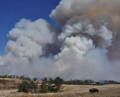
Unfortunately, we have lost much of this ancient wisdom. Combined with a human induced warming planet, we have created raging, “hot” wildfires that scorch the earth, which unleash severe negative impacts on the natural order.
Thankfully, now there is better understanding that the Indigenous peoples’ tradition of human-ignited burns is a valuable way to reduce out of control wildfires. Traditional ecological knowledge is being incorporated more into modern management. This increased understanding of Indigenous traditions has led to many partnerships between Tribal, state, and Federal governmental agencies, with the goal of reintroducing cultural burns in many parts of the United States.
This is Jack Greene for Bridgerland Audubon Society & I’m wild about indigenous wildfire wisdom!
Credits:
Images: Courtesy Pixabay, Michael Haderer a.k.a. haderer17, contributor
Featured Audio: Courtesy & Copyright Kevin Colver, https://wildstore.wildsanctuary.com/collections/special-collections and
Anderson, Howe, and Wakeman..
Text & Voice: Jack Greene, Bridgerland Audubon, https://bridgerlandaudubon.org/
Additional Reading Links: Jack Greene & Lyle Bingham, https://bridgerlandaudubon.org/
Additional Reading:
Wild About Utah Pieces by Jack Greene, https://wildaboututah.org/author/jack/
Abrahamson, Ilana L. 2013. Fire regimes in Hawai’ian plant communities. In: Fire Effects Information System, [Online]. U.S. Department of Agriculture, Forest Service, Rocky Mountain Research Station, Fire Sciences Laboratory (Producer). https://www.fs.usda.gov/database/feis/fire_regimes/Hawaii/all.html
CKST (Confederated Salish and Kootenai Tribes). 2021. Fire on the Land: Native People and Fire in the Northern Rockies. Confederated Salish and Kootenai Tribes, Division of Fish, Wildlife, Recreation & Conservation. http://fwrconline.csktnrd.org/Fire/index.html
Natcher, David C., et al. “Factors Contributing to the Cultural and Spatial Variability of Landscape Burning by Native Peoples of Interior Alaska.” Ecology and Society, vol. 12, no. 1, 2007. JSTOR, http://www.jstor.org/stable/26267834. Accessed 15 Mar. 2026.
David C. Natcher. “Implications of Fire Policy on Native Land Use in the Yukon Flats, Alaska.” Human Ecology, vol. 32, no. 4, 2004, pp. 421–41. JSTOR, https://www.jstor.org/stable/4603529. Accessed 15 Mar. 2026.
Panek, D. and Kipfmueller, K. 2021. Apostle Islands 50th Anniversary Resource Stewardship Symposium. Day 1. April 1, 2021. https://friendsoftheapostleislands.org/2021/04/01/past-present-and-future-of-fire-in-the-apostle-islands/
Roos, Dave. 2020. Native Americans Used Fire to Protect and Cultivate Land. Indigenous people routinely burned land to drive, prey, clear underbrush and provide pastures. https://www.history.com/news/native-american-wildfires
White, G., Rockwell, D., and McDuff, E. 2021. Embracing Indigenous Knowledge to Address the Wildfire Crisis. U.S. Department of the Interior, Office of Wildland Fire. https://www.doi.gov/wildlandfire/embracing-indigenous-knowledge-address-wildfire-crisis
Avitt, Andrew, Tribal and Indigenous Fire Tradition, Fire & Aviation Management, USDA Forest Service, November 16, 2021, https://www.fs.usda.gov/about-agency/features/tribal-and-indigenous-fire-tradition


