
Colorado Plateaus Province
US Physiographic Province
Courtesy US National Park Service
If you have ever been to a museum you have witnessed historical items that may be hundreds, or thousands of years old. When we look outdoors at the natural geology of our planet earth, we may be witnessing things that are hundreds of thousands, or even millions of years old.
I realize that there are some people who disagree with the aging with which some scientists label various mountains and canyons, so let’s just settle on the fact that some of these places are very, very old.
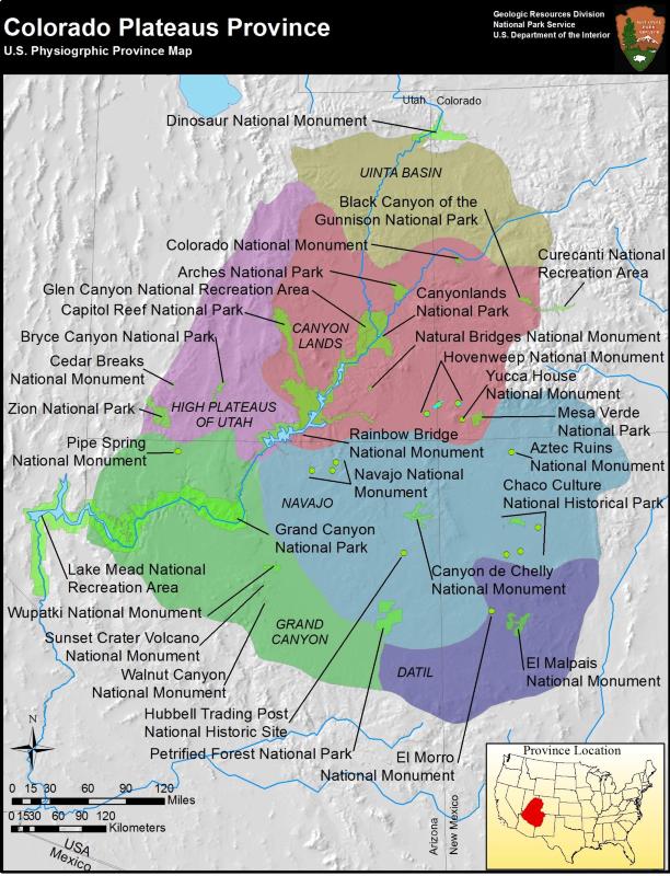
There is only one place in the United States where a person can put his feet and hands in four different States at the same time, and that place is called The Four Corners. The story behind this incredible area deals with the formation of what is known as the Colorado Plateau. This area covers 130,000 square miles in Utah, Colorado, New Mexico, and Arizona. If you have ever been to any of Utah’s Mighty Five National Parks you are on the Colorado Plateau, but it’s much more than that. There are 3 national recreation areas, 10 national parks, and 16 national monuments all included in that amazing geologic formation.
Scientists say that millions of years ago tropical seas covered the Plateau region where layers of limestone, sandstone, silt and shale were continually deposited. When upheavals began to lift the plateau, and mountain-building events occurred, volcanic eruptions also accented the western area. Eras of various rivers, lakes, and inland seas continued to leave sediment deposits known as the Chinle, Moenave and Kayenta layers. Later, a huge desert formed the Navajo, Temple-Cap and Carmel formations.
Tectonic activity began to uplift the Plateau nearly two miles high and slightly tilt it to the west. Rivers and streams responded with increased downcutting and erosion which revealed scenic wonders from narrow slot-canyons to huge cuts in the earth’s surface. Perhaps you have heard the term “Grand Staircase” which describes the descent in altitude from Bryce Canyon down to Zion Canyon and further down to the Grand Canyon in Arizona. About ninety percent of the area is drained by just a few rivers including the Colorado, Green, San Juan, Little Colorado and the Rio Grand.
Why emphasize the geology? Besides climate, think how the soil and rock formations determine water retention and flow directions. How water and soil then determines the plant life in an area. And finally, how all three of those components determine what wildlife will exist in that same area.
So the next time you visit Utah’s Mighty Five: Arches, Bryce Canyon. Canyonlands, Capitol Reef, or Zion Canyon, try to picture yourself atop a huge natural table-top with incomparable scenery.
This is Ron Hellstern, and I am Wild About Utah.
Credits:
Images: Courtesy & Copyright
Audio: Courtesy and Copyright Kevin Colver
Text: Ron Hellstern, Cache Valley Wildlife Association
Additional Reading
Colorado Plateaus Province, Physiographic Provinces, National Park Service, https://www.nps.gov/articles/coloradoplateaus.htm
Geologic Provinces of the United States: Colorado Plateau Province, USGS Geology in the Parks, USGS, https://archive.usgs.gov/archive/sites/geomaps.wr.usgs.gov/parks/province/coloplat.html
Annerino, John, Colorado Plateau Wild and Beautiful, Farcounty Press, April 1, 2014, https://www.amazon.com/Colorado-Plateau-Wild-Beautiful-Annerino/dp/156037585X
Hylland, Rebecca, What are Igneous, Sedimentary & Metamorphic Rocks?, Glad You Asked, Utah Geological Survey, https://geology.utah.gov/map-pub/survey-notes/glad-you-asked/igneous-sedimentary-metamorphic-rocks/