A Short History of Logan River

Over fifteen thousand years ago, the glacially fed Logan River was flowing into Lake Bonneville which covered most of the NW quadrant of the state and completely filled Utah’s Cache Valley.

The river met the ancient Lake Bonneville some distance up Logan Canyon so it was much shorter. Animals that lived along the river included saber-toothed cats, woolly mammoths and giant ground sloths.

About ten thousand years later, after Lake Bonneville had disappeared, the Logan River meandered across the old lake bed and the Shoshone Native American tribe made Cache Valley their home.
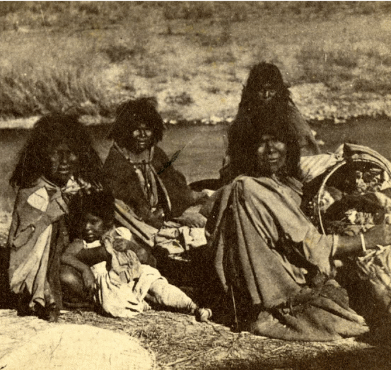
Shoshone Women and Children. Photo taken in 1870, Unknown photographer. Courtesy USU Digital History Collections.
Frank Howe, chairman of the Logan River Task Force, adjunct associate professor, and university liaison for Utah Division of Wildlife Resources said, “When people say ‘let’s return Cache Valley to how it was naturally’ they don’t realize the valley [had been] managed by the Shoshone for thousands of years before the settlers arrived.”

The Shoshone burned the valley frequently to drive the Bison and provide better forage for their horses. This impacted the vegetation across the valley and along the river. Instead of large stands of tall trees, the river was lined with shrubs which responded better to fire, hence the valley’s first name Willow Valley.

Water flowing in Right-hand Fork one of the tributaries of Logan River. Courtesy & Copyright Shauna Leavitt
During this time the flow and movement of the Logan River was much different, in part because of the beaver families who built their homes and dams up and down the waterway. The dams created ponds whose waters seeped into the valley bottoms raising the water table and saturating the sponge. Joseph Wheaton, associate professor of the Department of Watershed Sciences in the Quinney College of Natural Resources explained, “the saturated ground increased resilience to drought, flood and fire.”

In the early 1800s trappers arrived in the valley.

Michel Bourdon was one of the earliest trappers to see Cache Valley around 1818. The river was, for a short time, named after him. A few years later, Ephraim Logan arrived in Cache Valley. He and many other trappers attended the Rocky Mountain Rendezvous along the Bourdon River in 1826. Shortly thereafter, Logan died during one of his outings and the area’s trappers decided to rename the river Logan, in his honor.

Trapping for the fur industry severely impacted the beaver population and the Logan River. The dam building beavers were almost trapped to extinction because of the European fashion demand. Luckily, fashion trends changed before beaver were extinct. However, the virtual elimination of beavers fundamentally changed the character of the Logan River to this day.

Man fly-fishing in Logan River, Logan Canyon, Utah, July 21, 1937. Courtesy of USU Digital History Collections.
In the 1850s the first settlers arrived in Cache Valley. Their arrival had a large impact on Logan River. Within a year they began constructing the first canal for irrigation.

Logan’s Main Street about 1920, Courtesy of Darrin Smith
Around the turn of the 19th century it became apparent the grazing and timber need of the settlers had been hard on the Logan River and the surrounding landscape. Albert F. Potter surveying the Logan River watershed for President Theodore Roosevelt, reported the canyon had been overgrazed and its timber overcut. The timber, at the time, was used for railroad ties and to build Logan City.

Logan Canyon about 1910. Four waterways: the aquaduct which was used for power generation, the canal, a water way that ran behind the building which had been part of the old Hercules Power Plant, and the Logan River. Photographer H.G. Hutteballe, Courtesy of Darrin Smith Photo Collection
As the valley’s population grew, so did the demand for Logan River water.

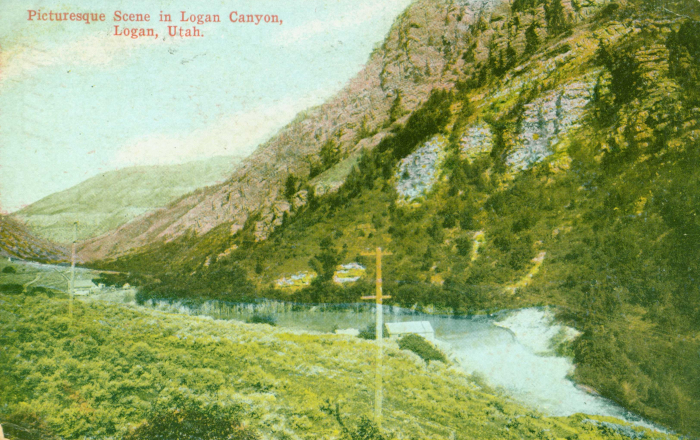
Color enhanced photo 1910 photo of Logan Canyon Courtesy Logan Library
Color enhanced photo 1910 photo of Logan Canyon
Courtesy Logan Library
Over the next few months, Wild About Utah will continue this series on the Logan River to tell the stories about its ecology, social value, and how humans have worked together to make it a community amenity not just a canal.

We hope you’ll join us as we learn more interesting facts about Logan River.

This is Shauna Leavitt and I’m wild about Utah.

Credits:
Photos: Courtesy & Copyright ©
Audio: Courtesy & Copyright © Friend Weller, Utah Public Radio
Text: Shauna Leavitt, Utah Cooperative Fish and Wildlife Research Unit, Quinney College of Natural Resources, Utah State University
Co-Authored by: Frank Howe, chairman of the Logan River Task Force, adjunct associate professor, and university liaison for Utah Division of Wildlife Resources.

Sources & Additional Reading

Geologic Map of the Logan 7.5′ Quadrangle, Cache County, Utah, Utah Geological Survey, 1996, https://ugspub.nr.utah.gov/publications/misc_pubs/mp-96-1.pdf

Williams, Stewart J. Lake Bonneville: Geology of Southern Cache Valley, Utah, Geological Survey Professional Paper 257-C, US Department of the Interior, 1962, https://pubs.usgs.gov/pp/0257c/report.pdf

Biek, Bob; Willis, Grant; Ehler, Buck; Utah’s Glacial Geology, Utah Geological Survey, September 2010, https://geology.utah.gov/map-pub/survey-notes/utahs-glacial-geology/

Hylland, Rebecca, What are Igneous, Sedimentary & Metamorphic Rocks?, Glad You Asked, Utah Geological Survey, https://geology.utah.gov/map-pub/survey-notes/glad-you-asked/igneous-sedimentary-metamorphic-rocks/

Utah’s Desert Paradox

Utah's Desert Paradox: Upheaval Dome Courtesy Wikimedia Licensed under the Creative Commons Attribution-Share Alike 3.0 Unported license.
Upheaval Dome
Courtesy Wikimedia
Licensed under the Creative Commons Attribution-Share Alike 3.0 Unported license.
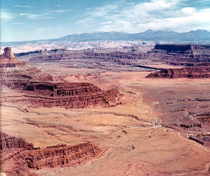
Have you ever wondered why the redrock landscape of Southeastern Utah ebbs and flows, why the exposed layers of sedimentary rock seem to rise and fall in crests and troughs like so many waves across the surface of the sea? Well, the answer, surprisingly enough, can be found through investigating the ancient seas that once covered vast swathes of Southeast Utah more than 300 million years ago.

Utah's Desert Paradox: Salt Diapir Courtesy Geology.com
Salt Diapir
Courtesy Geology.com
Back then, the allotment of Earth’s crust that would one day become the Beehive State was located along the western edge of a chain of islands that rose above a shallow, equatorial sea. 15 million years of sea level rise, recession, and evaporation left behind layer upon layer of salt deposits that would eventually measure nearly a mile thick. These salt deposits were subsequently covered and crushed by vast layers of sediment, rock, and debris eroded from the flanks of the Ancestral Rocky Mountains. Under the tremendous weight of these additional layers, the now lithified layers of salty stone softened and squirted west like toothpaste through a tube until they collided with deep tectonic faults. Here, they erupted upward, forcing the younger, denser rock layers into anticlinal arched domes, called diapirs, resembling the crests of waves. This phenomenon works much like a waterbed across the landscape: heavier rock layers squirting salt into thinner layers of rock that then bulge upward before they are subsequently squashed downward again by even more sediment, rock, and debris. The subterranean movement of salt through rock layers becomes a game of geologic whack-a-mole.

Utah's Desert Paradox: Cane Creek Anticline Canyonlands National Park Courtesy USGS, Public Domain, Photo id: 249988
Cane Creek Anticline
Canyonlands National Park
Courtesy USGS, Public Domain, Photo id: 249988
I recently visited Dead Horse Point State Park between the town of Moab and Canyonlands National Park. On the eastern edge of the rising mesa on which the park is located, one can look out across millions of years’ worth of sedimentary deposits toward the Cane Creek Anticline, an obvious salt diapir that seems to rise straight out of the Colorado River. Perhaps the most famous (and most contested) salt diapir in the area, though, is that of Upheaval Dome, located in Canyonlands National Park. An alternative theory to the creation of Upheaval Dome maintains that an ancient meteor impact created the crater where Upheaval Dome is located. However, the fracturing of the younger Wingate Sandstone that occupies the higher rock layers is indicative of a salt diapir formation. Yet, debate rages on!

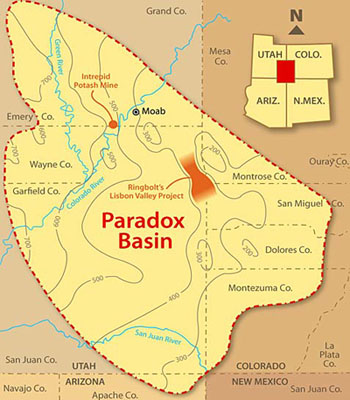
Utah's Desert Paradox: Paradox Basin Overview Courtesy & Copyright Buffalo Royalties
Paradox Basin Overview
Courtesy & Copyright Buffalo Royalties
Funnily enough, the discovery of this layer of ancient salt deposits that wreaks so much havoc below the Earth’s surface was made in the collapsed center of an ancient salt diapir. In 1875, geologist and surveyor Albert Charles Peale, at the time yet unaware of the salt tectonics at work beneath the Colorado Plateau, noted the paradoxical course of the Delores River. As Peale and his colleagues would find out, the geography of the collapsed salt diapir caused the river to chart a perpendicular course through its valley as opposed to a parallel course as is most often taken by rivers. This paradox of fluvial geomorphology gave the place its name, Paradox Valley. Likewise, the subsequent discovery of an entire basin of ancient salt deposits borrowed the name “Paradox.” Now, we know the salty layer as the Paradox Formation of rocks found throughout the Paradox Basin of the Colorado Plateau.

Utah's Desert Paradox: Paradox Valley Courtesy & Copyright GJhikes.com
Paradox Valley
Courtesy & Copyright GJhikes.com
This paradox of fluvial geomorphology can also be found where the Colorado River cuts a perpendicular course across the Spanish Valley of Moab and is indicative of a vast layer of ancient salts below the surface, waiting to further morph the landscape into crests and troughs of rocky waves that ebb and flow across the landscape. The next time you venture into this part of our great state, stop and consider the remnants of ancient seas below your feet that project their image into the surface of the redrock above.

I’m Josh Boling, and I’m Wild About Utah.

Utah’s Desert Paradox-Credits:

Photos: Paradox Basin Overview, Courtesy and Copyright Buffalo Royalties
Upheaval Dome Courtesy Wikimedia, https://commons.wikimedia.org/wiki/File:UpheavalDomePanorama.jpg
Salt Diapir Courtesy Geology.com, https://geology.com/stories/13/salt-domes/
Paradox Valley Courtesy GJhikes.com, https://www.gjhikes.com/2017/10/long-park.html
Cane Creek Anticline Courtesy USGS (Photo id: 249988 – Canyonlands National Park, Utah. Cane Creek anticline, looking northeast toward the La Sal Mountains from Dead Horse Point. The Colorado River cuts across the crest at the middle right, above which is Anticline Overlook. A jeep trail and part of Shafer dome lie below. Figure 13, U.S. Geological Survey Bulletin 1327. – ID. Lohman, S.W. 10cp – lswc0010 – U.S. Geological Survey – Public domain image)
Text: Josh Boling, 2018

Utah’s Desert Paradox-Additional Reading

Davis, Jim, Glad You Asked: Why Does A River Run Through It?, Glad You Asked, Utah Geological Survey, https://geology.utah.gov/map-pub/survey-notes/glad-you-asked/why-does-a-river-run-through-it/

What is a Salt Dome?. Geology.com, https://geology.com/stories/13/salt-domes/

Hylland, Rebecca, What are Igneous, Sedimentary & Metamorphic Rocks?, Glad You Asked, Utah Geological Survey, https://geology.utah.gov/map-pub/survey-notes/glad-you-asked/igneous-sedimentary-metamorphic-rocks/
Utah’s Desert Paradox

Cougars in Utah

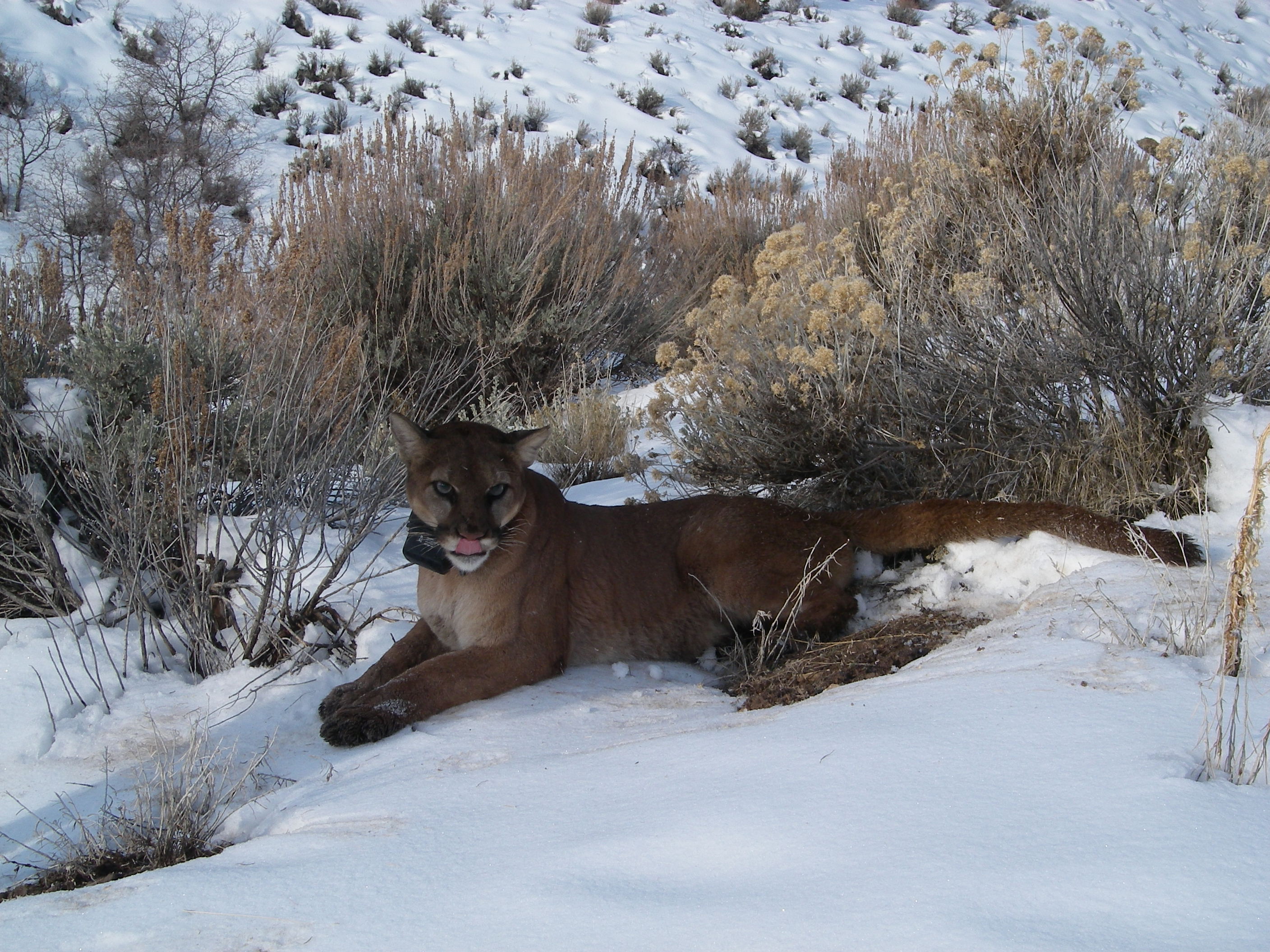
Cougars in Utah: FemaleF43, Butterfield Canyon, 2009 Courtesy and Copyright David Stoner
Female F43, Butterfield Canyon, 2009
Courtesy and Copyright David Stoner
Cougars are more widely distributed in Utah than many residents realize. These shy cats are found across the state. They roam from the high Uinta Mountains to the dry southern deserts.

David Stoner, assistant professor in the Department of Wildland Resources in the Quinney College of Natural Resources who has studied cougars for the past two decades said, “[Cougars] are common in terms of their distribution, but are rare in terms of their numbers. They live in many places but there are never a lot of them, typically occurring at densities of 1 adult per 20 square miles.

Stoner continues, “They’re just a big cat. Most of us are familiar with a house cats, and know how they behave, their movements, and idiosyncrasies. The main difference is their size. Cougars can be as large as humans [males usually range between 110 to 180 lbs.] They have evolved to take prey larger than themselves. You see this in the size of their muzzle – the mouth, nose and jaw. All of that is much larger in a cougar relative to its own body than a house cat. This becomes even more dramatic in the really big cats like tigers and lions with very large muzzles.

Stoner partnered with Utah Division of Wildlife Resources (DWR) to study cougars in two Utah areas, one of which was Monroe Mountain in Fishlake National Forest.

Mother named F61 (face showing), daughter (F58c) (facing away) Approx 1.5 yrs old in January 2011. Location: Kennecott mine, Bingham Canyon in the Oquirrh Mountains, Utah Courtesy and Copyright McLain Mecham, Photographer
Mother named F61 (face showing), daughter (F58c) (facing away) Approx 1.5 yrs old in January 2011. Location: Kennecott mine, Bingham Canyon in the Oquirrh Mountains, Utah
Courtesy and Copyright McLain Mecham, Photographer
The researchers noticed an unusual movement pattern of juveniles on the mountain. When the young were ready to leave their mothers they could have migrated in any direction to find good habitat but they disproportionately chose to go either NE or SE. This perplexed the researchers.

At about the same time the cougar research was winding down, DWR was starting a mule deer monitoring program.

Stoner said, “We were very fortunate. What DWR found was the Monroe Mountain deer herd were mostly migrating NE and SE. I looked back at our data and found the cougars who were leaving Monroe were going in the same direction as the deer migrations, the young cougars were tracking the deer herds.

Due to their hunting methods and nutritional needs, cougars require large home ranges. Researchers gathered data from NV, UT and AZ to represent a wide range of environmental conditions from very dry systems close to Las Vegas to relatively wet systems along Wasatch front.

Stoner explains, “We found the size of the home ranges…varied with precipitation. The wettest areas the cougars had the smallest home ranges, because of the abundance of prey in these highly productive systems. Females tend to have ranges strictly based on the food they need. The male’s range is much larger because they are looking for breeding opportunities, so they overlap numerous females. These ranges can be quite large. One collared male had a home range of over 2,500 square miles, which was visible on maps at the scale of the entire western United States.”

When it comes to human interactions with cougars, Utah has been very fortunate. In the past 100 years, no humans have been killed by a cougar. In hopes of maintaining this record, DWR keeps safety tips on its website. The most important tip is to never run from a cougar, this will cause them to instinctively think you are prey and begin the chase. If you have a child with you pick them up. Stand firm and look intimidating, let it know you’ll fight back. Your goal is to scare them off.

With the wise actions of humans, Stoner and DWR hope this majestic cat will continue to flourish in Utah.

This is Shauna Leavitt and I’m Wild About Utah.

Credits:
Photos: Courtesy & Copyright © David Stoner
Audio: Courtesy
Principal Investigator: David Stoner, https://qcnr.usu.edu/directory_cv/D.Stoner_CV_10-2016.pdf
Text: Shauna Leavitt, Utah Cooperative Fish and Wildlife Research Unit, Quinney College of Natural Resources, Utah State University

Sources & Additional Reading

Greene, Jack, My Cougar Encounter, Wild About Utah, January 16, 2017, https://wildaboututah.org/my-cougar-encounter/

Strand, Holly, Mountain Lion, Wild About Utah, March 4, 2010, https://wildaboututah.org/mountain-lion/

Boling, Josh, Wild Cats, Wild About Utah, December 10, 2018, https://wildaboututah.org/wild-cats/

Löe J. and E. Röskaft. 2004. Large Carnivores and Human Safety: A Review. AMBIO: A Journal of the Human Environment Aug 2004 : Vol. 33, Issue 6, pg(s) 283-288 https://www.researchgate.net/publication/8328070_Large_Carnivores_and_Human_Safety_A_Review

Larese-Casanova, Mark, Mountain Wildlife Field Book, Utah Master Naturalists, https://extension.usu.edu/utahmasternaturalist/files/UMNP_Mountains_Wildlife_Book_booklet.pdf

Rice, Andy, Voices: Cougars have cost me thousands. That doesn’t mean I want them all killed., The Salt Lake Tribune, Jan. 20, 2026, https://www.sltrib.com/opinion/commentary/2026/01/19/voices-cougars-have-cost-me/

Rock Art

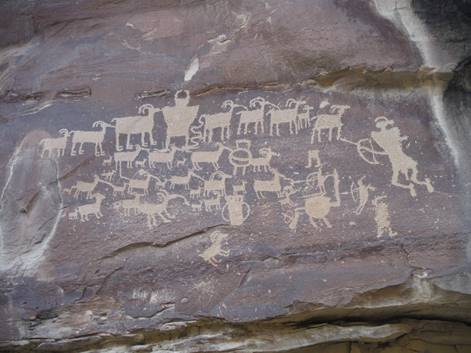
Rock Art: Fremont Petroglyphs in Nine Mile Canyon, UT: Courtesy & Copyright Josh Boling, Photographer
Fremont Petroglyphs in Nine Mile Canyon, UT: Courtesy & Copyright Josh Boling, Photographer
What did we do before radio—before cell phones, television, newspapers, and books? How did we tell stories, share news, warn of danger, or otherwise communicate with anyone beyond those around us? What did we do with words and thoughts when there was no one with whom we could immediately share them? The wilds of southern Utah can provide one answer—if you’re willing to look.

Rock Art: The Great Gallery Pictograph Panel in Horseshoe Canyon, UT; Courtesy & Copyright Josh Boling, Photographer
The Great Gallery Pictograph Panel in Horseshoe Canyon, UT; Courtesy & Copyright Josh Boling, Photographer
As far as pictograph panels go, Horseshoe Canyon’s Great Gallery isn’t terribly difficult to find. It’s also one of the most spectacular and well preserved panels of rock art in the state. Naturally, then, it’s fairly well-known and has seen an increasing number of visitors in recent years despite its remote location. Incidentally, I happened upon it by accident—had no idea it was there and would have passed right by if not for a chance glimpse of a ghostly set of eyes peering at me through cottonwood boughs. The Great Gallery’s ‘Barrier Canyon’ style of rock art is characterized by haunting silhouettes of human, semi-human, and animal figures painted on and pecked into the canyon walls of the Colorado Plateau. They are surviving remnants of an unnamed and unknown culture of hunter/gatherers that roamed Utah’s canyon country between 7,000 and 1,500 years ago—pieces of information whose meaning is lost to us now. We may never know why these people painted the “Holy Ghost”—the 8-foot-tall figure with empty, gaping eyes that startled me out of my hiking stupor.

Newer panels of rock art produced by more familiar cultures are a bit more discernible, though. The nameless wanderers who produced the Barrier Canyon style were followed first by the Fremont whose artwork appeared around 1,500 and 2,000 years ago and then by the Pueblo peoples we now refer to as the Anasazi. Both the Fremont and Pueblo styles portray relatively clearer themes—stories of hunting parties and the game to which they gave chase; spirals and directional glyphs which indicate water; people, animals, and the elements whose interactions are now carved into the canyon walls for us to find, decipher, and celebrate.

The author, adventurer, and local rock art expert Jonathan Bailey refers to rock art as “a vision of a…cultural landscape”—a story continuously told by people who lived close to the land long after they’ve passed. Some stories are secret, hidden away in forgotten crevices of the Colorado Plateau, meant only for those who already knew their meaning. Others are more democratic: a water glyph is meant for me as much as the hunter/gatherer that pecked it into the sandstone. It beckons every traveler to come and sate his or her thirst.
Einstein said time is relative. Looking up at the Holy Ghost, the artistic center of the Great Gallery, I felt I could reach through time and connect with the people who wandered this landscape before me—to see it and experience it the way they did.

I’m Josh Boling, and I’m Wild About Utah.

Credits:
Photos: Courtesy & Copyright Josh Boling
Sound: Courtesy & Copyright Kevin Colver
Text: Josh Boling, 2018

Sources & Additional Reading

Mozdy, Michael, Bold Figures, Blurred History: The Great Gallery in Horseshoe Canyon, Natural History Museum of Utah, October 2, 2016, https://nhmu.utah.edu/blog/2016/09/29/bold-figures-blurred-history-great-gallery-horseshoe-canyon

Nine Mile Canyon, Natural History Museum of Utah, https://nhmu.utah.edu/places/nine-mile-canyon