A Short History of Logan River

Over fifteen thousand years ago, the glacially fed Logan River was flowing into Lake Bonneville which covered most of the NW quadrant of the state and completely filled Utah’s Cache Valley.

The river met the ancient Lake Bonneville some distance up Logan Canyon so it was much shorter. Animals that lived along the river included saber-toothed cats, woolly mammoths and giant ground sloths.

About ten thousand years later, after Lake Bonneville had disappeared, the Logan River meandered across the old lake bed and the Shoshone Native American tribe made Cache Valley their home.
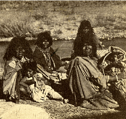
Shoshone Women and Children. Photo taken in 1870, Unknown photographer. Courtesy USU Digital History Collections.
Frank Howe, chairman of the Logan River Task Force, adjunct associate professor, and university liaison for Utah Division of Wildlife Resources said, “When people say ‘let’s return Cache Valley to how it was naturally’ they don’t realize the valley [had been] managed by the Shoshone for thousands of years before the settlers arrived.”

The Shoshone burned the valley frequently to drive the Bison and provide better forage for their horses. This impacted the vegetation across the valley and along the river. Instead of large stands of tall trees, the river was lined with shrubs which responded better to fire, hence the valley’s first name Willow Valley.
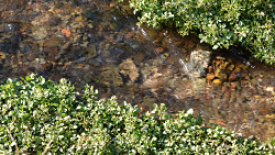
Water flowing in Right-hand Fork one of the tributaries of Logan River. Courtesy & Copyright Shauna Leavitt
During this time the flow and movement of the Logan River was much different, in part because of the beaver families who built their homes and dams up and down the waterway. The dams created ponds whose waters seeped into the valley bottoms raising the water table and saturating the sponge. Joseph Wheaton, associate professor of the Department of Watershed Sciences in the Quinney College of Natural Resources explained, “the saturated ground increased resilience to drought, flood and fire.”

In the early 1800s trappers arrived in the valley.

Michel Bourdon was one of the earliest trappers to see Cache Valley around 1818. The river was, for a short time, named after him. A few years later, Ephraim Logan arrived in Cache Valley. He and many other trappers attended the Rocky Mountain Rendezvous along the Bourdon River in 1826. Shortly thereafter, Logan died during one of his outings and the area’s trappers decided to rename the river Logan, in his honor.

Trapping for the fur industry severely impacted the beaver population and the Logan River. The dam building beavers were almost trapped to extinction because of the European fashion demand. Luckily, fashion trends changed before beaver were extinct. However, the virtual elimination of beavers fundamentally changed the character of the Logan River to this day.
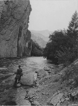
Man fly-fishing in Logan River, Logan Canyon, Utah, July 21, 1937. Courtesy of USU Digital History Collections.
In the 1850s the first settlers arrived in Cache Valley. Their arrival had a large impact on Logan River. Within a year they began constructing the first canal for irrigation.

Logan’s Main Street about 1920, Courtesy of Darrin Smith
Around the turn of the 19th century it became apparent the grazing and timber need of the settlers had been hard on the Logan River and the surrounding landscape. Albert F. Potter surveying the Logan River watershed for President Theodore Roosevelt, reported the canyon had been overgrazed and its timber overcut. The timber, at the time, was used for railroad ties and to build Logan City.

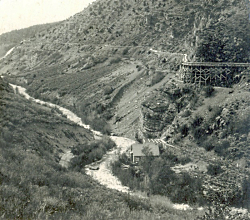
Logan Canyon about 1910. Four waterways: the aquaduct which was used for power generation, the canal, a water way that ran behind the building which had been part of the old Hercules Power Plant, and the Logan River. Photographer H.G. Hutteballe, Courtesy of Darrin Smith Photo Collection
As the valley’s population grew, so did the demand for Logan River water.

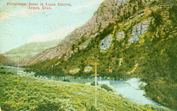
Color enhanced photo 1910 photo of Logan Canyon Courtesy Logan Library
Color enhanced photo 1910 photo of Logan Canyon
Courtesy Logan Library
Over the next few months, Wild About Utah will continue this series on the Logan River to tell the stories about its ecology, social value, and how humans have worked together to make it a community amenity not just a canal.

We hope you’ll join us as we learn more interesting facts about Logan River.

This is Shauna Leavitt and I’m wild about Utah.

Credits:
Photos: Courtesy & Copyright ©
Audio: Courtesy & Copyright © Friend Weller, Utah Public Radio
Text: Shauna Leavitt, Utah Cooperative Fish and Wildlife Research Unit, Quinney College of Natural Resources, Utah State University
Co-Authored by: Frank Howe, chairman of the Logan River Task Force, adjunct associate professor, and university liaison for Utah Division of Wildlife Resources.

Sources & Additional Reading

Geologic Map of the Logan 7.5′ Quadrangle, Cache County, Utah, Utah Geological Survey, 1996, https://ugspub.nr.utah.gov/publications/misc_pubs/mp-96-1.pdf

Williams, Stewart J. Lake Bonneville: Geology of Southern Cache Valley, Utah, Geological Survey Professional Paper 257-C, US Department of the Interior, 1962, https://pubs.usgs.gov/pp/0257c/report.pdf

Biek, Bob; Willis, Grant; Ehler, Buck; Utah’s Glacial Geology, Utah Geological Survey, September 2010, https://geology.utah.gov/map-pub/survey-notes/utahs-glacial-geology/

Hylland, Rebecca, What are Igneous, Sedimentary & Metamorphic Rocks?, Glad You Asked, Utah Geological Survey, https://geology.utah.gov/map-pub/survey-notes/glad-you-asked/igneous-sedimentary-metamorphic-rocks/
Extinction or Survival?

Extinction or Survival: Environmental Protection Image by <a href="https://pixabay.com/users/ejaugsburg-148268/?utm_source=link-attribution&utm_medium=referral&utm_campaign=image&utm_content=326923">ejaugsburg</a> from <a href="https://pixabay.com/?utm_source=link-attribution&utm_medium=referral&utm_campaign=image&utm_content=326923">Pixabay</a>
Environmental Protection
Image by ejaugsburg from Pixabay
Some people complain that the NEWS only reports bad things, and that can be depressing. But maybe that is the way we can learn how to improve things. If all we ever heard was that everything was wonderful, even though it truly wasn’t, how would we feel if we accidentally stumbled across a negative situation? Let’s consider the present global status of the wildlife with which we share this planet.

One of the pleasures of hiking in scenic vistas, such as our forests or National Parks, is to see the wildlife that call those places home. People want to see bears or wolves in Yellowstone. They are thrilled when they see Desert Bighorn Sheep in Arches or Zion. But the latest comprehensive report on biodiversity by the United Nations revealed some startling results. The report included over 1,000 pages compiled by more than 450 researchers who analyzed 15,000 scientific and government reports. And this summary had to be approved by representatives of all 109 nations.

The message is that nature is being threatened more now than any other time in human history. Literally, a million species of plants and animals are facing serious threats to their survival. And this is due to several harmful actions: Invasive species that crowd out native wildlife from their home habitats; the pollution of water and land by the dumping or runoff of toxic materials; overfishing the oceans; and permitting the continual burning of fossil fuels which alter the climate for some wild species. And, as a result of increasing human populations, many forests and grasslands are converted into farmland, cities, or business ventures. That reduction in the number of large plants and trees affects the Earth’s ability to reduce heat-trapping carbon dioxide.

Currently, over 1,200 mammal species, 1,500 bird species, and 2,300 fish species are threatened, endangered or extinct in the wild.

This indeed sounds dismal, but if we consider it as a warning there is still time left to alter this downward spiral. What can we do? Simple tasks, really: Replace lawns by planting trees, shrubs and flowers native to your area. This provides habitat as well as food for pollinators. Avoid using harmful pesticides and herbicides which can collect and wash down into streams and rivers, which then pollute that water as well as the ocean. Respect the privacy needed by wildlife by observing them from a distance. Never poach any species. Place birdfeeders and/or birdhouses in your area. Consider renewable energy sources for your home and community. Don’t allow your vehicle engines to idle. And encourage your community to preserve open, green spaces when new developments are proposed.

Life is easier if we decide to let others do the work that will benefit us all. But if everyone made some small improvements in their lifestyle we might be able to avoid future dismal reports.

This is Ron Hellstern, and I am Wild About Utah.
 
Extinction or Survival-Credits:

Images: Courtesy & Copyright
Lead Audio: Courtesy and Copyright Kevin Colver
Text: Ron Hellstern, Cache Valley Wildlife Association

Extinction or Survival-Additional Reading

Utah Porcupines

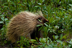
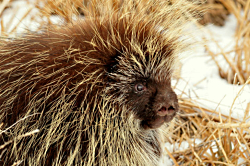
Utah Porcupines: North American Porcupine Erethizon dorsatum Courtesy US FWS Tom Koerner, photographer
North American Porcupine
Erethizon dorsatum
Courtesy US FWS
Tom Koerner, photographer
It was late evening at our 3rd annual Utah Youth Environmental Summit at the Wasatch Mountain Lodge above Brighton Ski Resort. We were winding down the day when someone happened to look out the window which elicited a high volume shriek.

“What is it?!” A gnarly looking beast had cozied up to the window. Its face was a mixture of the grotesque and cuteness. A throng of students rushed to the window. “A porcupine!!” None of the 30 students had seen one in the wild. The questions began. “Can it shoot its quills at you?” “What do they eat?” “Do they bite?” “Do they hibernate”? And so on.

Utah Porcupines: North American Porcupine Erethizon dorsatum Courtesy US FWS Lisa Hupp, photographer
North American Porcupine
Erethizon dorsatum
Courtesy US FWS
Lisa Hupp, photographer
Having grown up in the north woods of Wisconsin and Michigan, I could answer most of their questions. No, it does not shoot its quills, but beware of its strong tail which it uses to impregnate quills with a quick slap at the assailant. And no, it doesn’t hibernate and yes, they can bite! Further, they are excellent swimmers and tree climbers. Also, their quills, which are similar to our fingernails made of keratin, can regrow once lost.
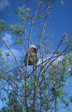
Unfortunately, most of the porcupines I’ve happened on have been road kills. The others have been in trees where they may spend considerable time eating the bark and stems. A large pile of fecal material may be found at the trees base similar to that of grouse in shape and size.

Another thing I learned is they adore outhouses and will greatly enlarge the holes as whey chew away the salty urine flavored wood. They also have a penchant for ax handles and canoe paddles where salt accumulates from ones laboring hands.

They are long lived- up to 30 years in captivity. I later learned that our Wasatch Mountain Lodge beast had become habituated, a regular visitor looking for a bit of garbage or a treat.

A few other tidbits worthy of note. Porcupines tend to be solitary animals except for when they are mating or caring for their young. They can use caves, old trees, and logs to create their dens, in which they may remain for many days in inclement weather. They possess a wide-variety of calls including moans, grunts, coughs, wails, whines, shrieks and tooth clicking.

Utah Porcupines: Porcupine in a Tree Erethizon dorsatum Courtesy US FWS Public Domain
Porcupine in a Tree
Erethizon dorsatum
Courtesy US FWS
Public Domain
Late summer and early fall are the mating times. They make a great deal of vocalizations to draw a mate to them and to keep other males out of the area. Males become very aggressive, the strongest winning the female for which he will dance and then urinate on her for further affection. What!! Typically only one young is born seven months later. The baby’s quills are very soft for delivery, then harden after an hour. They remain with mother for about 6 months.

Predators are often deterred by the rattling of its hollow quills after which an offensive odor may occur. If the above threats fail, the porcupine will attack by running sideways or backwards while swinging its quilled tail in the direction of the predator.

Their magical quills are being researched by medical scientists to create adhesives, improve needle penetration, and for antibacterial properties. They also had extensive use by Native Americans for exquisite decorative purposes, and their bodies served up a fine meal- with quills removed!

This is Jack Greene and I’m wild about Utah porcupines!

Credits:

Pictures: Courtesy US FWS, Lisa Hupp and Tom Koerner, photographers
Sound: Courtesy
Text: Jack Greene, Bridgerland Audubon Society

Additional Reading:

Can a Porcupine Shoot its Quills? Smithsonian Channel, youTube, March 2, 2015,

Porcupines, Wild Aware Utah, (Utah DWR, Hogle Zoo, USU Cooperative Extension) https://www.wildawareutah.org/utah-wildlife-information/porcupines/

Utah’s Desert Paradox

Utah's Desert Paradox: Upheaval Dome Courtesy Wikimedia Licensed under the Creative Commons Attribution-Share Alike 3.0 Unported license.
Upheaval Dome
Courtesy Wikimedia
Licensed under the Creative Commons Attribution-Share Alike 3.0 Unported license.
Have you ever wondered why the redrock landscape of Southeastern Utah ebbs and flows, why the exposed layers of sedimentary rock seem to rise and fall in crests and troughs like so many waves across the surface of the sea? Well, the answer, surprisingly enough, can be found through investigating the ancient seas that once covered vast swathes of Southeast Utah more than 300 million years ago.

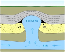
Utah's Desert Paradox: Salt Diapir Courtesy Geology.com
Salt Diapir
Courtesy Geology.com
Back then, the allotment of Earth’s crust that would one day become the Beehive State was located along the western edge of a chain of islands that rose above a shallow, equatorial sea. 15 million years of sea level rise, recession, and evaporation left behind layer upon layer of salt deposits that would eventually measure nearly a mile thick. These salt deposits were subsequently covered and crushed by vast layers of sediment, rock, and debris eroded from the flanks of the Ancestral Rocky Mountains. Under the tremendous weight of these additional layers, the now lithified layers of salty stone softened and squirted west like toothpaste through a tube until they collided with deep tectonic faults. Here, they erupted upward, forcing the younger, denser rock layers into anticlinal arched domes, called diapirs, resembling the crests of waves. This phenomenon works much like a waterbed across the landscape: heavier rock layers squirting salt into thinner layers of rock that then bulge upward before they are subsequently squashed downward again by even more sediment, rock, and debris. The subterranean movement of salt through rock layers becomes a game of geologic whack-a-mole.

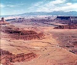
Utah's Desert Paradox: Cane Creek Anticline Canyonlands National Park Courtesy USGS, Public Domain, Photo id: 249988
Cane Creek Anticline
Canyonlands National Park
Courtesy USGS, Public Domain, Photo id: 249988
I recently visited Dead Horse Point State Park between the town of Moab and Canyonlands National Park. On the eastern edge of the rising mesa on which the park is located, one can look out across millions of years’ worth of sedimentary deposits toward the Cane Creek Anticline, an obvious salt diapir that seems to rise straight out of the Colorado River. Perhaps the most famous (and most contested) salt diapir in the area, though, is that of Upheaval Dome, located in Canyonlands National Park. An alternative theory to the creation of Upheaval Dome maintains that an ancient meteor impact created the crater where Upheaval Dome is located. However, the fracturing of the younger Wingate Sandstone that occupies the higher rock layers is indicative of a salt diapir formation. Yet, debate rages on!

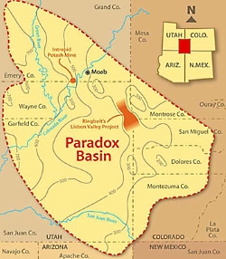
Utah's Desert Paradox: Paradox Basin Overview Courtesy & Copyright Buffalo Royalties
Paradox Basin Overview
Courtesy & Copyright Buffalo Royalties
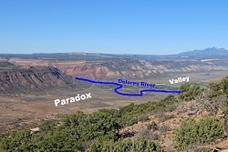
Funnily enough, the discovery of this layer of ancient salt deposits that wreaks so much havoc below the Earth’s surface was made in the collapsed center of an ancient salt diapir. In 1875, geologist and surveyor Albert Charles Peale, at the time yet unaware of the salt tectonics at work beneath the Colorado Plateau, noted the paradoxical course of the Delores River. As Peale and his colleagues would find out, the geography of the collapsed salt diapir caused the river to chart a perpendicular course through its valley as opposed to a parallel course as is most often taken by rivers. This paradox of fluvial geomorphology gave the place its name, Paradox Valley. Likewise, the subsequent discovery of an entire basin of ancient salt deposits borrowed the name “Paradox.” Now, we know the salty layer as the Paradox Formation of rocks found throughout the Paradox Basin of the Colorado Plateau.

Utah's Desert Paradox: Paradox Valley Courtesy & Copyright GJhikes.com
Paradox Valley
Courtesy & Copyright GJhikes.com
This paradox of fluvial geomorphology can also be found where the Colorado River cuts a perpendicular course across the Spanish Valley of Moab and is indicative of a vast layer of ancient salts below the surface, waiting to further morph the landscape into crests and troughs of rocky waves that ebb and flow across the landscape. The next time you venture into this part of our great state, stop and consider the remnants of ancient seas below your feet that project their image into the surface of the redrock above.

I’m Josh Boling, and I’m Wild About Utah.

Utah’s Desert Paradox-Credits:

Photos: Paradox Basin Overview, Courtesy and Copyright Buffalo Royalties
Upheaval Dome Courtesy Wikimedia, https://commons.wikimedia.org/wiki/File:UpheavalDomePanorama.jpg
Salt Diapir Courtesy Geology.com, https://geology.com/stories/13/salt-domes/
Paradox Valley Courtesy GJhikes.com, https://www.gjhikes.com/2017/10/long-park.html
Cane Creek Anticline Courtesy USGS (Photo id: 249988 – Canyonlands National Park, Utah. Cane Creek anticline, looking northeast toward the La Sal Mountains from Dead Horse Point. The Colorado River cuts across the crest at the middle right, above which is Anticline Overlook. A jeep trail and part of Shafer dome lie below. Figure 13, U.S. Geological Survey Bulletin 1327. – ID. Lohman, S.W. 10cp – lswc0010 – U.S. Geological Survey – Public domain image)
Text: Josh Boling, 2018

Utah’s Desert Paradox-Additional Reading

Davis, Jim, Glad You Asked: Why Does A River Run Through It?, Glad You Asked, Utah Geological Survey, https://geology.utah.gov/map-pub/survey-notes/glad-you-asked/why-does-a-river-run-through-it/

What is a Salt Dome?. Geology.com, https://geology.com/stories/13/salt-domes/

Hylland, Rebecca, What are Igneous, Sedimentary & Metamorphic Rocks?, Glad You Asked, Utah Geological Survey, https://geology.utah.gov/map-pub/survey-notes/glad-you-asked/igneous-sedimentary-metamorphic-rocks/
Utah’s Desert Paradox