Preserving the Social and Ecological Values of a Utah River

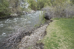
Preserving the Social and Ecological Values of a Utah River: Stewart Park1_Pre-construction Serious Bank Erosion: Serious erosion resulting, in part, from upstream channelization cuts into Stewart Park Courtesy & Copyright © Frank Howe, Photographer
Stewart Park1_Pre-construction Serious Bank Erosion: Serious erosion resulting, in part, from upstream channelization cuts into Stewart Park
Courtesy & Copyright © Frank Howe, Photographer
In 2011, extensive flooding in Cache Valley caused widespread damage to both buildings and land along the Logan River.
Preserving the Social and Ecological Values of a Utah River
This led to the formation of the Logan River Task Force; this group of Utah State University scientists and other experts in riparian and river restoration worked with Logan City and Bio-West, Inc. (a local consulting firm) to develop a long-term restoration plan that prevented flooding while balancing both social and ecological values of the river.
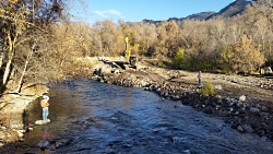
During Construction: Restoration specialists direct construction of the Stewart Park "Residential Demonstration" Restoration Project Courtesy & Copyright © Frank Howe, Photographer
During Construction: Restoration specialists direct construction of the Stewart Park “Residential Demonstration” Restoration Project
Courtesy & Copyright © Frank Howe, Photographer
Frank Howe, chairman of the Task Force said, “We developed the Logan River Conservation Action Plan to help ensure people’s property is protected, BUT we also envisioned the river becoming an amenity for our community – a place where people could enjoying activities [in, on, and around] the river such as canoeing, hiking, and fishing, or just sitting – enjoying the sights and sounds of the river.”
The Task Force’s first objective was to answer the question, “Why do people value the river?”
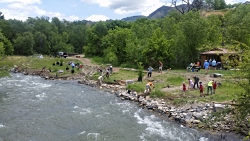
Volunteer Planting: Community volunteers plant native vegetation in the terraced demonstration area at the Stewart Park site, vegetation helps slow the flow and reduce the river's energy during a flood. Courtesy & Copyright © Frank Howe, Photographer
Volunteer Planting: Community volunteers plant native vegetation in the terraced demonstration area at the Stewart Park site, vegetation helps slow the flow and reduce the river’s energy during a flood.
Courtesy & Copyright © Frank Howe, Photographer
With the help of Logan’s citizens, the Task Force developed 22 Indicators of the river’s values. These indicators were essential for creating the Conservation Action Plan and directing restoration activities. People are anxious to avoid flood damage, but they’re also interested in the fish and wildlife the river supports as well as the recreational opportunities it offers.

Logan City Mayor Holly Daines said, “The Logan River Task Force has been really helpful to the city in working on river restoration! Quality of life is such an important part of our community. By expanding trails, and restoring the river wherever possible, we’re [creating] great places where we can enjoy [a] little slice of nature.”

Restoration after 1 year: The completed restoration features native vegetation, bark trails, and places where people can access the river. Courtesy & Copyright © Frank Howe, Photographer
Restoration after 1 year: The completed restoration features native vegetation, bark trails, and places where people can access the river.
Courtesy & Copyright © Frank Howe, Photographer
The Task Force’s first restoration effort was a demonstration project at Denzil Stewart Nature Park. Its purpose was to show residents who live along the river how they could enhance their property while providing benefits to the river and their neighbors. “A lot of people have built walls so the river doesn’t flood onto their property”, says Howe. “But this leads to channelization which creates a problem for the [whole] river system. It forces the entire flow of the river into a very confined space. That increases the erosive power of the river which then eats away at personal property and public infrastructure.”

The Stewart Park Project demonstrated that, instead of building walls, if the owner allows occasion flooding onto lower “terraced” areas which are planted with native vegetation, it allows the river to grow a little wider and this, along with the friction from the vegetation, slows the flow and dissipates the energy of the flood through the entire [river] system.
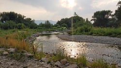
A family enjoys the river one year after the Rendezvous Restoration Project. Courtesy & Copyright © Frank Howe, Photographer
A family enjoys the river one year after the Rendezvous Restoration Project.
Courtesy & Copyright © Frank Howe, Photographer
The flagship project of the Task Force was Rendevous Park where the river was rerouted to avoid flood damage to a major highway and railroad. Pools were created in the river to catch sediments that previously plugged the river, causing flooding. Howe explains, “The pools allow sediments to drop out in a very predictable place which can be cleaned out every 5-10 years as sediments build up. These pools also provide excellent fish habitat as well as places for people to float or wade in the river. We removed several acres of non-native vegetation and planted native trees, shrubs, and wildflowers which created habitat for birds and other wildlife. We also added trails that allow people to access the river without disturbing the plantings. In all, we were able to improve 19 of the 22 social and ecological Indicators!”

This approach of balancing social and ecological values in river restoration used by the Logan River Task Force can be applied to rivers throughout Utah.

This is Shauna Leavitt and I’m wild about Utah.

Preserving the Social and Ecological Values of a Utah River-Credits:
Preserving the Social and Ecological Values of a Utah River
Photos: Courtesy & Copyright © Frank Howe, USU QCNR/Utah DWR
Audio: Courtesy & Copyright © Friend Weller, Utah Public Radio
Text: Shauna Leavitt, Utah Cooperative Fish and Wildlife Research Unit, Quinney College of Natural Resources, Utah State University
Co-Authored by: Frank Howe, chairman of the Logan River Task Force, adjunct associate professor, and university liaison for Utah Division of Wildlife Resources.

Preserving the Social and Ecological Values of a Utah River-Additional Reading

Leavitt, Shauna, Logan River’s Evolving Geomorphology, Wild About Utah, March 2, 2019, https://wildaboututah.org/logan-rivers-evolving-geomorphology/

Leavitt, Shauna, The Ecology in and around the Logan River, Wild About Utah, December 2, 2019, https://wildaboututah.org/the-ecology-in-and-around-the-logan-river/

Leavitt, Shauna, A Short History of the Logan River, Wild About Utah, November 4, 2019, https://wildaboututah.org/short-history-of-logan-river/
Hope

Hope: Crocus Courtesy Pixabay
Crocus
Courtesy Pixabay
It feels odd to be denning in the spring. Our usual season to escape back into the out of doors has shifted radically for society at-large. It is odd because all the world around us is still warming, flying a little further each day, and here we are, humanity, digging in. It is for the best, for our own survival, but it is still not easy to go against the natural grain.

Hunkering down has affected us all, myself included. At first I was angry with frustration, as I’m sure you were too. I wanted something or someone to blame, to witness and call wrong. I struggled to find meaning in any of it; I struggled to hear anything but fear. It took me a while to come to remind myself that this frustration, this search for orientation, is the human way; it is natural to feel as we do in the omnipresence of the unknown.

What I discovered though is that this perspective, natural as it may be, is harmful if lived too long. My search was a dangerous one: for some externality of blame in an effort to begin to wrest back seeming control. When this is the path you choose to take, you find, as I did, that your anger is not quenched, but instead stoked. My focus was consumed by a blackness; it burned into my eye like a mariner’s missing star.

How then does one change course towards hope, and if not acceptance, then duty, empathy, and discipline for our fellow man? How do we get through such times?

The Greek philosopher Heraclitus said that “For God all things are good and right and just, but for man some things are right and others are not.” When I do not understand the world, the world I love so dearly, I think of these ancient words. I am reminded of this wisdom as I find myself unconsciously passing judgement upon the things I cannot control, and it stops me. In this wisdom I am reminded that, while there may be something to fear, there is no righteousness to my anger. True righteousness instead stems from the lessons of spring; the lessons of hope: of living on with tenacity, industry, and love, even in the face, however distant, of winter.

The righteousness of hope is found, too, in our choice to harness our actions with humble intention in light of what is happening in the world and the toll that is being taken. And just as fear is begotten in the meandering anger of blame, hope lives in our individual conscious actions. Only together can our actions create constellations for others to follow: cosmos among the chaos, shining brighter than the void’s pull. That we will all choose to do what is right, though it will not be easy, even in the face of doubt and fear, gives me hope.

So from the crocuses, the robins, and the fresh mud of our beautiful Utah spring, don’t forget that the world is still good and continues to be every day, even if sometimes it does not feel like it. Remind yourself of the lessons of spring by opening your window, listening to the birds, smelling deep the thawing air, and choosing to den in these times, fulfilling the spring lessons of tenacity, industry, and love. Choose to fix yourself as another orienting light of hope for those who still only see the night, or those who do not look up at all, for the world is good, it is everywhere, and we will always be of it. Here is to the persistence of life and hope found in us all this spring.

I’m Patrick Kelly, and I’m Wild About Utah.
 
Hope-Credits:

Images: Image Courtesy Pixabay
Audio: Contains audio Courtesy & Copyright Kevin Colver
Text:    Patrick Kelly, Director of Education, Stokes Nature Center, https://logannature.org
Included Links: Lyle Bingham, Webmaster, WildAboutUtah.org

Hope-Additional Reading

Campbell, Joseph, Moyers, Bill, The Power of Myth, Bantum Books, Knopf Doubleday Publishing, Excerpt Courtesy Google Books, Heraclitus said: For God all things are good and right and just, but for man some things are right and others are not.

Jack’s Nuthatches In Three Varieties

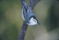
Jack's Nuthatches In Three Varieties: White-breasted nuthatch	 Sitta carolinensis Courtesy US FWS David Brenzinski, Photographer
White-breasted nuthatch
Sitta carolinensis
Courtesy US FWS
David Brenzinski, Photographer
Inverted woodpecker, a phrase I use to describe the feeding habits of the amazing nut hatch family. I first became aware of this lovely little songbird growing up in Michigan, where the white-breasted nut hatch was common fare in the north woods. Their little laughing notes were most welcome as I sat on my deer stand where I would watch them search bark crevices for yummy morsels of grubs, insect eggs or seeds they had wedged in for tomorrow’s snack.

Jack's Nuthatches In Three Varieties: Red Breasted Nuthatch Courtesy US FWS Dave Menke, Photographer
Red Breasted Nuthatch
Courtesy US FWS
Dave Menke, Photographer
Now having lived many years in Utah, it is the red-breasted nut hatch that has replaced this eastern cousin for the most part. Their “yank, yank, yank” vocalizations light up my life whenever and wherever they occur. They prefer conifers but will gladly substitute a deciduous tree, especially those with more furrowed bark. Where there is food or water, infrequently a white-breasted will appear, especially in our higher elevations, although I’ve had them join the red-breasted at our feeder during winter months – a rare treat.

Jack's Nuthatches In Three Varieties: Pygmy nuthatch, Sitta pygmaea, Courtesy US FWS Lee Karney, Photographer
Pygmy nuthatch
Sitta pygmaea
Courtesy US FWS
Lee Karney, Photographer
If one spends much time in our Ponderosa pine forests in central and southern Utah, another family member can be found. Unlike the other two more solitary species, these tiny pygmies occur in small flocks and are very chatty. Highly social, the pygmy nut hatch appear to enjoy a food frolic as they fly from tree to tree for feeding and social interaction. Thus, Utah’s blessed with all three North American species of nut hatch.

If you observe them as they search the main stem of a tree, my inverted woodpecker title will be justified. Rather than moving from top to bottom of the tree facing up as do the woodpeckers, the nut hatch prefers head down from top to bottom. They also like hanging upside down on a horizontal limb. Why? Evolution keeps us mysteries well-guarded. I conjecture partitioning might be part of the answer: a phenomenon where bird species will utilize different parts of the tree to avoid competing for resources with other species.

As with all of life, I pay attention to how our shifting climate has been observed or predicted to affect their populations and distribution. As long as there are conifers breeding season, nut hatches are content. They can be found in dry Ponderosa pine foothills, in moist boreal bogs, around tree line in the mountains, and even in planted Christmas tree plantations. Audubon’s seven-year generated climate model shows an overall northward drift of the species’ range with more disruption and range loss in summer than in winter. The nut hatch is a habitat generalist in winter, so summertime climate is the chief concern going forward. However, whether the species adapts in the decades ahead will be determined in large part by the conifer forest health in a changing climate. The projection for species range change from 2000 to 2080 is 19% of summer 2000 range remaining stable and 58% of winter range projected to be stable. It’s my plan to follow them wherever they may go.

Wild about Utah is brought to you in part by our listeners and the Moab area travel council, whose support of tourism events and recreation in Grand county promotes and protects the natural beauty for visitors from across the state of Utah. Information available online at discovermoab.com

This is Jack Green, reading and getting wilder about Utah as days pass.

Credits:

Pictures: Courtesy US FWS, David Brenzinski, Photographer
Contains Sound: Courtesy Kevin Colver
Text: Jack Greene, Bridgerland Audubon Society //Utah State University Sustainability

Additional Reading:

White-breasted Nuthatch, All About Birds, Cornell Lab of Ornithology, https://www.allaboutbirds.org/guide/White-breasted_Nuthatch/id

Red-breasted Nuthatch, All About Birds, Cornell Lab of Ornithology, https://www.allaboutbirds.org/guide/Red-breasted_Nuthatch/id

Pygmy Nuthatch, All About Birds, Cornell Lab of Ornithology, https://www.allaboutbirds.org/guide/Pygmy_Nuthatch/id

Red-breasted Nuthatch, Sitta canadensis, eBird, Cornell Lab of Ornithology, https://ebird.org/species/rebnut

Imaginary Wanderings

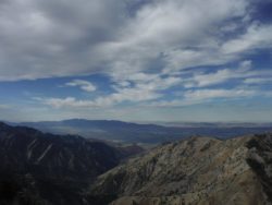
Imaginary Wanderings: The edge of the Great Basin, top of the Bear River Range Courtesy & Copyright Josh Boling, Photographer
The edge of the Great Basin, top of the Bear River Range
Courtesy & Copyright Josh Boling, Photographer
I’ve fancied a certain type of wandering lately—to grab my pack and boots and walk the lines of Utah’s political border—a trail made not of dirt and stone, but of imaginary lines of latitude and longitude. But, as of yet, I haven’t found the time or resources to do so beyond my own imagination and the 3 or 4 minutes I have with you now. Come join me in a stroll around Utah, at least the way I’ve imagined it.

Walking north out of Logan, I’ll wander through the grid-patterned neighborhoods that pepper the flanks of the Bear River Range, the still-snowy peaks that serve as sentinels over my daily commute and the adventure on which I embark now. They serve another, greater purpose, too, though. Without the Bear Rivers, the Rocky Mountains would be otherwise dissected. The snowy peaks I adore and which now pass in slow motion over my right shoulder form the only range of mountains that connect the northern and southern Rockies. Though they only measure about 70 miles in length, they provide a critical ecological thoroughfare from the south end of Cache Valley, Utah, north to Soda Springs, Idaho.

I won’t follow them that far, though. I’ll turn left (west) at the Idaho border toward the Great Basin.

I’m technically already there. We all are if we live along the Wasatch Front. And there are just a few minor ranges—the Clarkston Range, Blue Spring Hills, and the northern fingerling ridges of the Promontory Mountains—to wander across before reaching the Great Basin proper.

My favorite hidden gem of this often-overlooked portion of Utah are the Raft River Mountains. Like the mighty Uintas to the east, the Raft Rivers run East-to-West. So, despite being a stone’s throw from the Great Salt Lake, the tributaries running off their northern flanks drain not into the Great Basin and the Great Salt Lake, but north onto the Snake River Plain toward the Columbia River and, eventually, the Pacific Ocean.

The Tri Corners Landmark is a simple granite pillar sticking 3 or 4 feet out of the sand amongst wind-whipped sage brush. It’s easy to miss, but marks some interesting irregularities. Utah’s political border is not, in fact, made up of straight lines. According to cartographer Dave Cook, surveyors who created the state’s initial boundaries hastily covered ground with their crude survey instruments. They were paid by the mile, so they were more interested in finishing quickly than correcting any errors they made along the way.

The border wiggles at least four times by my calculations—one of which comprises two right angles—as it wanders across ridgelines and through the dusty draws of the basin and range mountains toward the Mojave Desert of southwest Utah.

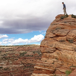
Imaginary Wanderings: The wrinkled topography if the Colorado Plateau Courtesy & Copyright Josh Boling, Photographer
The wrinkled topography if the Colorado Plateau
Courtesy & Copyright Josh Boling, Photographer
I won’t be there for long, though. The border only runs for roughly 50 miles along the two legs of the right triangle that constitutes Utah’s allotment of the Mojave Desert before it climbs up onto the Colorado plateau. Ed Abbey famously compared the wrinkled topography of Utah, particularly his beloved canyon country of the Colorado Plateau, to the two largest of our states. “Alaska is our biggest, buggiest, boggiest state,” Abbey wrote. “Texas remains our largest unfrozen state. But mountainous Utah, if ironed out flat, would take up more space on a map than either.” Ropes, technical climbing and canyoneering gear, and a fair amount of fortitude would be required here.

The eastern border we share with Colorado is a varied expanse of high desert plateaus, rugged cliffs, out-of-place riparian zones, and a few spectacular snow-capped mountain ranges leading through some of the most beautiful and gloriously desolate places on the planet. The Book Cliffs, Dinosaur National Monument, and the La Sal Mountains come to mind.

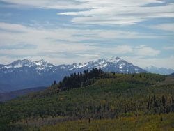
A short walk distance-wise would require heaps of route finding across the Green River’s Flaming Gorge and along the northern toes of the Uinta Mountains. Here is perhaps the greatest of Utah’s geologic juxtapositions. Low basins adjacent the Intermountain West’s highest peaks.

Imaginary Wanderings: A view of the high Uintas from their northern foothills Courtesy & Copyright Josh Boling, Photographer
A view of the high Uintas from their northern foothills Courtesy & Copyright Josh Boling, Photographer
I’ll take my first right turn at the western edge of the Uinta foothills. Here I might skip the formalities of a longitudinal walk—stick my thumb out instead, and make a bee-line for Bear Lake, Logan Canyon, and home: the walks I’ve already known for some time.

Perhaps you’re inspired now to know parts of this walk better yourself.

I’m Josh Boling, and I’m Wild About Utah!

Credits:

Imaginary Wanderings:
Photos: Courtesy and Copyright Josh Boling, Photographer
Audio: Includes audio from
Text: Josh Boling, 2020, Edith Bowen Laboratory School, Utah State University

Sources & Additional Reading

Boling, Josh, Why I Teach Outside, Wild About Utah, November 11, 2019, https://wildaboututah.org/why-i-teach-outside/

Kiffel-Alcheh, Utah, National Geographic Kids, https://kids.nationalgeographic.com/explore/states/utah/

The Geography of Utah, NSTATE LLC, https://www.netstate.com/states/geography/ut_geography.htm

Fisher, Albert L, Physical Geography of Utah, History to Go, Utah Division of State History, https://historytogo.utah.gov/physical-geography-utah/