Upheaval Dome Courtesy Wikimedia Licensed under the Creative Commons Attribution-Share Alike 3.0 Unported license. A Desert’s ParadoxHave you ever wondered why the redrock landscape of Southeastern Utah ebbs and flows, why the exposed layers of sedimentary rock seem to rise and fall in crests and troughs like so many waves across the surface of the sea? Well, the answer, surprisingly enough, can be found through investigating the ancient seas that once covered vast swathes of Southeast Utah more than 300 million years ago.
Salt Diapir Courtesy Geology.comBack then, the allotment of Earth’s crust that would one day become the Beehive State was located along the western edge of a chain of islands that rose above a shallow, equatorial sea. 15 million years of sea level rise, recession, and evaporation left behind layer upon layer of salt deposits that would eventually measure nearly a mile thick. These salt deposits were subsequently covered and crushed by vast layers of sediment, rock, and debris eroded from the flanks of the Ancestral Rocky Mountains. Under the tremendous weight of these additional layers, the now lithified layers of salty stone softened and squirted west like toothpaste through a tube until they collided with deep tectonic faults. Here, they erupted upward, forcing the younger, denser rock layers into anticlinal arched domes, called diapirs, resembling the crests of waves. This phenomenon works much like a waterbed across the landscape: heavier rock layers squirting salt into thinner layers of rock that then bulge upward before they are subsequently squashed downward again by even more sediment, rock, and debris. The subterranean movement of salt through rock layers becomes a game of geologic whack-a-mole.
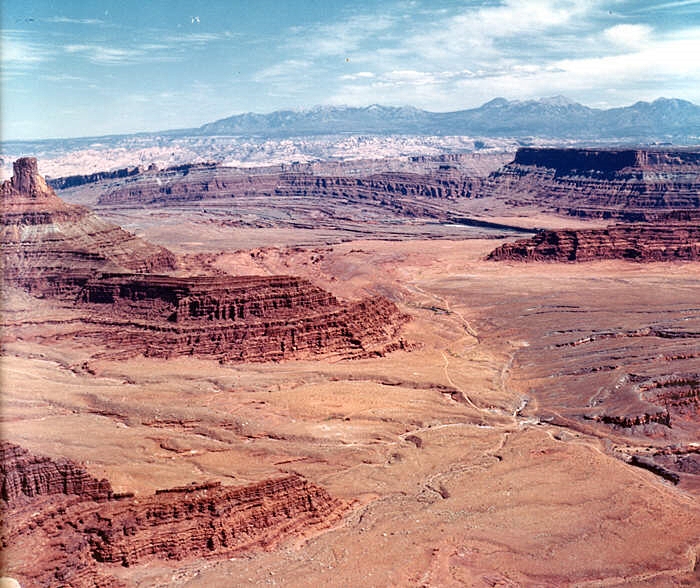
Cane Creek Anticline Canyonlands National Park Courtesy USGS, Public Domain, Photo id: 249988I recently visited Dead Horse Point State Park between the town of Moab and Canyonlands National Park. On the eastern edge of the rising mesa on which the park is located, one can look out across millions of years’ worth of sedimentary deposits toward the Cane Creek Anticline, an obvious salt diapir that seems to rise straight out of the Colorado River. Perhaps the most famous (and most contested) salt diapir in the area, though, is that of Upheaval Dome, located in Canyonlands National Park. An alternative theory to the creation of Upheaval Dome maintains that an ancient meteor impact created the crater where Upheaval Dome is located. However, the fracturing of the younger Wingate Sandstone that occupies the higher rock layers is indicative of a salt diapir formation. Yet, debate rages on!
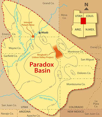
Paradox Basin Overview Courtesy & Copyright Buffalo RoyaltiesFunnily enough, the discovery of this layer of ancient salt deposits that wreaks so much havoc below the Earth’s surface was made in the collapsed center of an ancient salt diapir. In 1875, geologist and surveyor Albert Charles Peale, at the time yet unaware of the salt tectonics at work beneath the Colorado Plateau, noted the paradoxical course of the Delores River. As Peale and his colleagues would find out, the geography of the collapsed salt diapir caused the river to chart a perpendicular course through its valley as opposed to a parallel course as is most often taken by rivers. This paradox of fluvial geomorphology gave the place its name, Paradox Valley. Likewise, the subsequent discovery of an entire basin of ancient salt deposits borrowed the name “Paradox.” Now, we know the salty layer as the Paradox Formation of rocks found throughout the Paradox Basin of the Colorado Plateau.
Paradox Valley Courtesy & Copyright GJhikes.comThis paradox of fluvial geomorphology can also be found where the Colorado River cuts a perpendicular course across the Spanish Valley of Moab and is indicative of a vast layer of ancient salts below the surface, waiting to further morph the landscape into crests and troughs of rocky waves that ebb and flow across the landscape. The next time you venture into this part of our great state, stop and consider the remnants of ancient seas below your feet that project their image into the surface of the redrock above.
I’m Josh Boling, and I’m Wild About Utah.
A Desert’s Paradox-Credits:
Photos: Paradox Basin Overview, Courtesy and Copyright Buffalo Royalties
Upheaval Dome Courtesy Wikimedia, https://commons.wikimedia.org/wiki/File:UpheavalDomePanorama.jpg
Salt Diapir Courtesy Geology.com, https://geology.com/stories/13/salt-domes/
Paradox Valley Courtesy GJhikes.com, https://www.gjhikes.com/2017/10/long-park.html
Cane Creek Anticline Courtesy USGS (Photo id: 249988 – Canyonlands National Park, Utah. Cane Creek anticline, looking northeast toward the La Sal Mountains from Dead Horse Point. The Colorado River cuts across the crest at the middle right, above which is Anticline Overlook. A jeep trail and part of Shafer dome lie below. Figure 13, U.S. Geological Survey Bulletin 1327. – ID. Lohman, S.W. 10cp – lswc0010 – U.S. Geological Survey – Public domain image)
Text: Josh Boling, 2018
Most people could probably name the state bird or the state tree, but what about the state gem? The state grass? State fruit? Do you know why they are important to Utah? Here are just a few of Utah’s State Symbols that you might not have known.
Sherry-colored topaz from Maynard’s Claim (Pismire Knolls), Thomas Range, Juab County, Utah, USA, By Rob Lavinsky, iRocks.com – CC-BY-SA-3.0, CC BY-SA 3.0, https://commons.wikimedia.org/w/index.php?curid=10450654Topaz was named Utah’s state gem in 1969 because of its abundance on Topaz or Thomas Mountain in Juab County. In this area, perfect topaz crystals can be found and collected. This semiprecious gem can also be found in Beaver and Toole counties. Topaz can be found in a variety of colors, but in the Thomas Range it is known for its sherry hue. When exposed to sunlight, amber colored topaz will often become clear. Topaz collecting is free and open to the public in most areas and could be a great way to get to know Utah a little bit better.
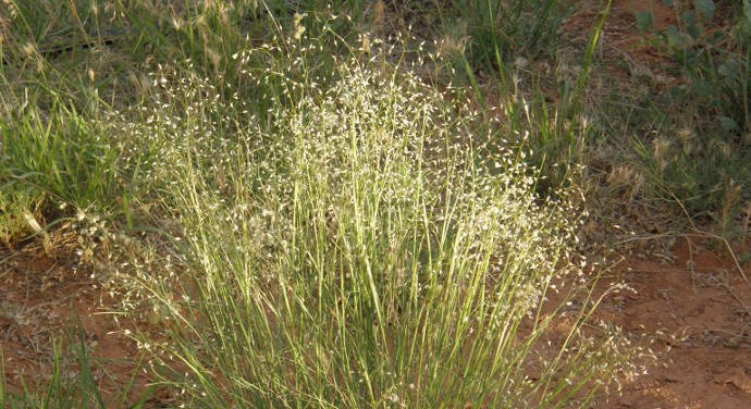
Utah’s state grass was selected in 1990 to be Indian Ricegrass. As you might suspect, indian ricegrass was given its name because of the significance in Native American life. This tough bunchgrass was a common food source and was absolutely crucial to survival when the corn crop failed. Indian Ricegrass Courtesy US National Park ServiceIt can be found in wet and dry areas throughout the West. Long ago this grass was important for Native Americans; now it is important in fighting wind erosion and grazing cattle.
The cherry did not become the state fruit until 1997 when a group of second graders did their research and petitioned for the fruit to be recognized. Cherry was discovered to be the most economically beneficial fruit for Utah when compared to other fruits like peaches and apples. Both sweet and tart cherries are grown commercially in Utah. Utah is the only state ranked in the top five cherry producing states for both types of cherries. US Cherries for sale in Korea Courtesy USDAThe cherry is native to Asia, but flourishes in Utah’s environment.
The state insect might be a little easier to guess than the state grass and state fruit. Utah is known as the beehive state, so naturally our state insect is the honeybee. When settlers first arrived in Utah they called it Deseret which means honeybee. Some native bees are listed as endangered species, but many Utahns have become “backyard beekeepers” to help these bees survive. Honeybee Extracts Nectar Courtesy NASA ClimateKidsBees might seem insignificant, but are actually the unsung heroes of the world’s food supply. Growing bee friendly plants or becoming a beekeeper yourself are great ways to help Utah’s honeybee thrive.
No matter where in the state of Utah you are, you can learn more about these plants, animals, and rocks and see them in action. As a Chinese proverb says, “Learning is a treasure that will follow its owner everywhere.”
This is Aspen Flake and I am Wild About Utah.
Credits:
Photos: Courtesy US NPS and US FWS
Audio: Courtesy and Copyright Kevin Colver
Text & Voice: Aspen Flake Additional Reading & Listening
Roosevelt and Muir at Glacier Point President Teddy Roosevelt and John Muir standing on rock at Glacier Point, Yosemite, May 1903; Yosemite Falls and cliffs of Yosemite Valley in distance. [RL012904] Courtesy US NPSIt is the place where the Great Spirit stood when He made the entire Earth. So said the resident Ahwahneechee Native Americans and, aesthetically speaking, few who have witnessed sunrise from the misty meadows of the Yosemite Valley will contend against their point of view.
It is one of the rare places where the onlooker can pivot in full-circle to take potential calendar photos exposed at every compass point. To the north cascades Yosemite Falls, fifth highest on the planet. Looking Eastward the signature logo of Yosemite National Park, Half-Dome, rises upward to meet the morning sun. To the south, magnificent Glacier Point captivates wide eyes and causes mouths to open in silent wonder. Gazing west, the ever-changing Merced River’s placid sheen soon reflects the grandeur of El Capitan, the largest granite monolith in the world.
Linking with Utah’s “Mighty Five National Parks” and Yellowstone as premier displays of American scenery, Yosemite lies at the far western point of that great triangle of unsurpassed natural western beauty. Each park is unique in its own way, but produces the same hypnotic responses in visitors whether surrounded by mountains of granite, sandstone canyons, or geothermal wonders.
Lafayette Bunnell, the army doctor credited with naming the valley, described his feelings as being one of the first white men to ever witness Yosemite.
“…suddenly we came in view of the valley of the Yosemite. The grandeur of the scene was softened by haze over the valley, light as gossamer, and by vapory clouds on the high cliffs. My astonishment was overpowering, and my eyes welled up with tears as I sensed my own inferiority. Here, before me, was the power and the glory of the Supreme Being. This seemed God’s holiest Temple where were assembled all that was most divine in material creation.”
A Morning Council on the Merced Group of about twenty-six Native Americans seated and standing beside a cedar bark structure, near the Merced River, Yosemite Valley, 1872. (Title as printed on stereograph A Morning Concert on the Merced is in error.) [RL014217] Photo Courtesy US National Park ServiceChief Tenaya, however, was devastated as his villages were torched, and he mourned, “When I am dead I will call to my people to come to you, that they shall hear me in their sleep. I will follow in your footsteps. I will not leave my home, but be with the spirits among the rocks, the waterfalls, the rivers, and in the winds. Wherever you go, I will be with you.”
Naturalist John Muir wrote about the place he called The Range of Light. The Sierras, 400 miles long and 80 miles wide of granitic wonder, also inspired him to advise, “Everybody needs beauty as well as bread, places to play in and pray in where nature may heal and cheer and give strength to the body and soul.”
Another of his quotes inspired six of us to hike to the top of Half Dome. “Climb the mountains and get their glad tidings. Nature’s peace will flow into you as sunshine flows into trees. The winds will blow their own freshness into you and the storms their energy, while cares drop off like autumn leaves.”
Although the trek is an arduous 16 miles with a 5,000 foot elevation gain, Muir was accurate. Climbing past thunderous Vernal and Nevada Falls, striding through heavily-scented coniferous forests and reaching the base of the Dome produced sensory overload with every step. Yet, dangers are evident. Signs along the way read simply: “If you fall, you will die.”
The sight of Half Dome’s crest from the bottom of the cable route can be intimidating. One third of the hikers reaching that point refuse the final 400-foot ascent and retreat to the valley floor. Determined to succeed, we pulled our way up the steel cables to the top where the view exceeded our anticipation. Lush green meadows below were garnished with silver threads of water, imposing granite peaks were embellished with emerald forests, swallows were jetting upward on thermal winds, and the sky was so blue one could scoop it into a bowl.
Bunnell, Tenaya, and Muir were correct. Nature has a way of providing even more than we seek.
This is Ron Hellstern for Wild About Utah
Credits:
Images: Courtesy US National Park Service Archives, Yosemite National Park
Text: Ron Hellstern, Cache Valley Wildlife Association
Additional Reading
Yosemite National Park, US National Park Service, https://www.nps.gov/yose/index.htm
Zion Narrows Courtesy & Copyright Rhett HellsternSeventeen miles, and three potential swims. If those two descriptors aren’t deterrents, great scenery awaits those who hike the Zion Narrows from the top down into the main canyon. If you run marathons, bike the LOTOJA race, or simply marvel at nature’s masterpieces, there is nothing intimidating about this adventure. However, if you are a professional armchair quarterback, you had better get some miles under your feet before attempting this adventure, especially if you want to complete it in one day.
I’ve been to Zion many times, but after seeing the inspirational film, “The Bucket List”,
I decided it was time to do this classic hike. Along with good luck, and good sense, the key to success lies in the preparation.
There is no marked trail because at least 60 percent of the hike is in the Virgin River and, although the air temperature was in the 90’s, the water was chilly when we had to do the three short swims. Groups are limited to 12, and permits are required, but Rangers won’t issue them is the flow rate goes above 120 cubic feet per second. We were fortunate and hit a day when it was flowing at 100 CFS.
Unless you reserve one of the dozen Narrow’s campsites for an overnight stay, plan on about 12 hours walking. Unfortunately, if you are too slow and miss the last shuttle bus at the Temple of Sinawava, you will add another 8 mile hike to return to your car at the Visitor Center.
River hiking can be like walking on greasy bowling balls. You can ruin your own shoes, or the Zion Adventure Company will rent sticky-soled boots, tight neoprene socks, and a walking stick. Unless you have two cars, they will also provide the 90-minute shuttle to the Chamberlain Ranch. They are helpful and show a training film about hiking the Narrows. Here you will learn to watch for the signs of deadly flash-floods. If it happens, immediately go to higher ground, available throughout the canyon…except in the “Wall Street” area. Check weather conditions with the Zion Backcountry Desk before you take your first step.
Wear layered clothing, use a river-bag for food and dry clothes, bring at least two liters of water or a good filter, and waterproof bags for your camera. Forget phones, they will not function there. Finally, borrowing a line from “The Bucket List”, (never pass up a bathroom) each hiker is provided with a human waste disposal bag.
To avoid packing extra food and sleeping bags, we were determined to do this as a day-hike. We had picked up our permit the night before, and saw the weather forecast at ten percent chance of light rain. Wanting to hit the trail early, we camped out on the east side of the park. After six hours of slumber-sweet, we let adrenaline pilot us toward the canyon. The first five miles were covered effortlessly, but the trail and shallow river finally transitioned into the copper-colored serpentine canyon we sought.
The Narrows is by far an acme of hikes in Zion. The sandstone walls ascend 2,000 feet, yet at times are only 20 feet apart at their base. For 12 miles we enjoyed incomparable scenery, waterfalls, small tributaries, sandbars where canyon maples provided alluring rest-stops, and the pleasantry was recorded with calendar-quality photos. But then we entered the “Danger Zone”.
True to its namesake, the Wall Street section was full of surprises. The sky darkened as though someone had pulled a black quilt over the canyon. Birds stopped singing. The wind picked up. Our ten percent chance of rain suddenly became one hundred percent! We were already wet, so we laughed…until the lightning flashed. Then thunder rumbled behind us so loudly we turned as if expecting freight trains to pummel us. Since there was no high ground, we picked up our pace and stuck close to the canyon walls. Seven people sloshing, wading, swimming, and helping each other to get to high boulders as soon as possible.
We reached safety the same time the storm stopped. The forecast was accurate. No flash-flood during our adventurous 12-hour journey and, yes, we caught the bus with time to spare. Would we do this hike again? Absolutely!
This is Ron Hellstern for Wild About Utah
Credits:
Images: Courtesy & Copyright Rhett Hellstern
Text: Ron Hellstern, Cache Valley Wildlife Association


![Majestic Yosemite: Roosevelt and Muir at Glacier Point President Teddy Roosevelt and John Muir standing on rock at Glacier Point, Yosemite, May 1903; Yosemite Falls and cliffs of Yosemite Valley in distance. [RL012904] Courtesy US NPS](https://wildaboututah.org/wp-content/uploads/nps.yosemite.roosevelt.and_.muir_.B15BD55C-155D-4519-3E97DDCE055E623F-large.jpg "Majestic Yosemite: Roosevelt and Muir at Glacier Point President Teddy Roosevelt and John Muir standing on rock at Glacier Point, Yosemite, May 1903; Yosemite Falls and cliffs of Yosemite Valley in distance. [RL012904] Courtesy US NPS")
![A Morning Council on the Merced Group of about twenty-six Native Americans seated and standing beside a cedar bark structure, near the Merced River, Yosemite Valley, 1872. (Title as printed on stereograph A Morning Concert on the Merced is in error.) [RL014217] Photo Courtesy US National Park Service](https://wildaboututah.org/wp-content/uploads/nps.yosemite.B15709A3-155D-4519-3ED096755F9FE6E3-large.jpg "A Morning Council on the Merced Group of about twenty-six Native Americans seated and standing beside a cedar bark structure, near the Merced River, Yosemite Valley, 1872. (Title as printed on stereograph A Morning Concert on the Merced is in error.) [RL014217] Photo Courtesy US National Park Service")
