Bear River basin
Courtesy Utah State Division of Water Rights
https://waterrights.utah.gov/techinfo/bearrivc/history.html I grew up in a town that had a story for nearly every run-down property in its borders. Most buildings had at least one ghost floating around its fence line, but the really haunted estate—the one where, supposedly, my great-great uncle plastered babies into the walls, where it’s said he threw his wife into the well, where the land itself swallows livestock and spits out bones, where you can still hear screams coiling up near the hackthorn bushes and willow trees—is just outside of town. Just far enough to escape the reach of the city lights, but not too far that you won’t make it back by morning. The location, more than its history, is probably the reason for the stories. If there is no journey, there is no room for stories to germinate.
My friend, Dr. Lynne S. McNeil, is a folklorist. She told me that it’s common for haunted things to happen in liminal spaces, in the places between places. So the haunted house on the edge of town makes sense. Just like it makes sense that most of the people who went to the haunted house were teenagers—not yet adults, but somehow not kids either. It’s human to seek out nooks to create the things we fear, and the things we feel compelled to lie about. She also told me about the theory of ostentation. People act out something of the legend to connect to the legend more. It’s not enough just to go to the haunted house, but you have to throw stones in the well to see if the motion of something falling will awaken the long murdered wife.
Bear River
Courtesy USDA Forest Service I now live near the geographic center of the Bear River drainage. I can walk to decent water from my house. But I hardly ever fish it. Mostly because the best fishing in Northern Utah is in Southern Idaho. Some of it is right on the border. There’s something in the trip. It’s more of an event even if the trip distance is increased by fifteen minutes. The Bear River travels nearly five-hundred miles, but its mouth and source are only separated by about 100 miles. It starts and ends in Utah, but crosses the borders of five states. It’s the largest river in North America that doesn’t flow to an ocean. It is known for its calm meanderings and its white-water kayak sections. It is America’s caveat river. Almost as an homage to the river that always needs an explanation, I choose to travel to it. I choose to fish those tributaries that feed the river instead of the convenient pull-outs where the Bear threads the road. I like to follow the fish to where they spawn. I’m always looking for the less obvious place to fish because everyone knows the story goes that you have to work for the big fish. Fishing trips need time to steep both before and after fishing. Where, if you fish with others, they’ll tell you how the fishing is going to be or was that day. Where, if you fish alone, you’ll think about how the fishing will actually be or was that day. You’ll compare it to other times at the same place and you’ll remember both real and imaginary fish. If there isn’t a space between fishing and not fishing to think and create, if you don’t drive past water that looks fine in search of great water, the fishing won’t be as good. I’ll never be a guy who spends more time on the road consistently than in the river—but, I’ll always give the fish and the river the respect of a drive.
Utah streams offer excellent year-round fishing opportunities for every level of angler. According to the Department of Natural Resources, Utah’s waters are home to approximately 80 different species of fish, but it is the trout fishing that is the biggest attraction for fishermen. Of the trout species swimming in our rivers and lakes, the cutthroat trout is a local favorite and the only trout native to the state.
The cutthroat trout represents the most diverse trout species in North America. They are a freshwater fish of the Salmonidae family that live in cold, clear streams and lakes across the west. Cutthroat trout are distinguished from other trout species by two red slashes prominently striping the lower jaw after which they are named. All cutthroat trout share a single common ancestor, but historic population isolation gave rise to 14 subspecies, each endemic to their own geographic region and river drainage.
There are four subspecies that exist in Utah. Only three of these are considered native to the state: the Colorado River cutthroat, the Yellowstone cutthroat, and Utah’s state fish, the Bonneville cutthroat. In Utah, the Colorado River cutthroat trout can be found in some of the smaller streams and tributaries of the Green River, the San Juan River, and the Colorado River drainages. Their bright coloration and posterior black spotting distinguish these cutthroats from others.
Pure, native Yellowstone cutthroat trout are present in small numbers in the streams of the North Slope of the Raft River Mountains in northwestern Utah. However, this subspecies is more widely distributed across the state due to extensive stocking. Yellowstone cutthroat trout can be differentiated by larger-sized black spots concentrated near the tail and their gold, gray, and copper tones.
The Bonneville cutthroat trout evolved in the Bonneville Basin of Utah, Wyoming, Idaho, and Nevada. Its primary ancestors were a population of lake dwelling cutthroat trout living in the late-Pleistocene aged Lake Bonneville. The Bonneville cutthroat trout is less vividly colored and has spots that are more sparsely and evenly distributed across the body than other cutthroats. Thought to be extinct in the 1970s, populations of the Bonneville cutthroat trout are now estimated to exist in around 35% of their historic range, including the nearby Weber and Provo Rivers.
Like so many species, the native cutthroat trout of Utah are under significant pressure due to drought, habitat loss, disease, and competition with non-native species. Though only the Colorado River cutthroat is included on the Utah State Sensitive species list, conservation of all of Utah’s native cutthroat populations is a focal point for state wildlife resource managers.
For Wild About Utah, I’m Anna Bengtson of Park City.
The Cutthroat Trout-a Local Favorite-Credits:
Images: Courtesy USDA Forest Service, US Bureau of Land Management & Chadd VanZanten.
Text: Anna Bengston
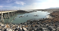
The Great Salt Lake Breach Courtesy U.S. Geological Survey
Department of the Interior/USGS
Mike Freeman, Photographer
10 Nov 2015 Water flowing through the Great Salt Lake breach in 2011, when lake levels were high due to above average snowfall in the Wasatch and Uinta Mountains. The Great Salt Lake breach is an area that allows water to travel between the southern and northern parts of the lake. There is a giant among us with a profound influence on our past, present, and future. My first encounter with this giant was both buoyant and delightful as I floated in the brine on a lovely summer day. But I was oblivious to the Great Salt Lake’s immense value as an environmental, cultural, and economic resource.
Much of what follows is taken from a very recently released collaborative study titled “Impacts of Water Development on Great Salt Lake and the Wasatch Front” which was a collaborative effort from four institutions(Utah State University, Utah Division of Water Resources, Salt Lake Community College, and the Utah Division of Wildlife Resources.)
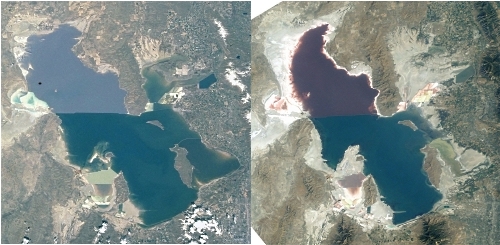
A 2012 analysis by Bioeconomics estimated the economic value of the lake at $1.32 billion per year for mineral extraction, brine shrimp cyst production, and recreation. The abundant food and wetlands of the lake attract 3 million shorebirds, as many as 1.7 million eared grebes, and hundreds of thousands of waterfowl during spring and fall migrations. Because of this, it has been designated as a Western Hemisphere Shorebird Reserve Network Site. Due to its enormous surface area, it produces the “lake affect” which enhances our snow pack by an estimated 8%, a significant amount for both skiers and our available water. But our giant is shrinking.
Since the arrival of 19th Century pioneers water diversions for irrigation have decreased its elevation by 11 feet exposing much of the lake bed. Natural fluctuations in rainfall and river flow cause the lake level to rise and fall, but there has been no significant long‐term change in precipitation and water supply from the main tributaries since their coming in 1847.
The Great Salt Lake Breach Credit: U.S. Geological Survey Department of the Interior/USGS Mike Freeman, Photographer 10 Nov 2015 For the first time since it was opened in 1984, water has stopped flowing through the Great Salt Lake causeway breach, an area that allows water to travel between the southern and northern parts of the lake. To significantly reduce water use, a balanced conservation ethic needs to consider all uses, including agriculture, which consumes 63 percent of the water in the Great Salt Lake Basin. There are no water rights to protect our Great Lake, so water development currently focuses solely on whether there is water upstream to divert. If future water projects reduce the supply of water to the lake, (such as the Bear River Development Project, its level will (most likely) continue to drop.
We must look beyond the next few decades and decide how we value the lake for future generations. Lower lake levels will increase dust pollution and related human health impacts, and reduce industrial and environmental function of Great Salt Lake. We must be willing to make decisions now that preserve Great Salt Lake’s benefits and mitigate its negative impacts into the coming centuries.
John Muir, one of my favorite early American naturalists would most certainly agree with me. From his baptismal plunge into the Great Salt Lake. “I found myself undressed as someone else had taken me in hand and got myself into right lusty relationship with the brave old lake. I was conscious only of a joyous exhilaration….”
And where else could John and I have such a wonderfully buoyant experience?
Find Your Park Courtesy US NPS Utah is arguably blessed with the most stunning landscapes on the planet. Many have been preserved for posterity in our National Parks & Monuments. This is the BIG YEAR- the 100 year anniversary of the National Park Service! I’ve sampled and worked in many of them- from Alaska to Florida, from S. California to New England. As many would suggest- our National Parks are one of America’s greatest achievements which has gone global, now found on all continents except Antarctica (or am I missing one!).
Much of my work in the Parks has been assisting with the launch of the “Climate Friendly Parks” program which began in 2006. The program provides parks with the tools and resources to address climate change and ensure the most sustainable operations across the agency.
National parks, because of their location and unique, protected resources, are places where the effects of climate change are particularly noticeable. With the establishment of the National Park Service in 1916, responsibility was given to the Service to preserve and protect the significant resources within parks for the enjoyment of current and future generations. Today, as knowledge about climate change and its effects increase and potential impacts are better understood, the need to practice good stewardship and develop forward thinking resource management plans is more relevant than ever.
I began in Zion N.P. then moved on to several others including Mt. Rainier, Olympic, Rocky Mountain, and Denali in Alaska. Zion N.P. will always be at or near the top for its amazing landforms, shear grandeur, hidden canyons, and rich diversity of life- the highest in Utah.
It was here that I first met the ringtail cat and Mexican Spotted Owl- two illusive, iconic critters. Both appeared in broad daylight in Hidden Canyon on the west face of the Great White Throne. There is no season less than spectacular here. Perhaps the most dramatic accompanies the seasonal monster thunder storms amplified by massive sandstone cliffs which begin spouting 2000 foot blood red waterfalls. It’s all too surreal, too ethereal for one’s senses to fully grasp.
And yet another proposed stunning Utah landscape containing thousands of ancient ruins is receiving wide citizen support including many native tribes, that being the Bears Ears NationalMonument.Find Your Park Courtesy US NPS This area of South Eastern Utah offers a unique opportunity to include the “real Americans”, the people that have over 10,000 years of Utah history, who continue to honor and worship this ancient landscape of their ancestors. These tribes have been invited to participate in its planning and management to assure their rituals and subsistence ways may continue, and that its pristine nature would be preserved in perpetuity.
Designation of the Bears Ears NM would be a marvelous celebratory note for this epic year to honor America’s grandest idea!
This is Jack Greene for Wild About Utah.
Credits:
Image: Courtesy National Park Service for Find Your Park
Courtesy BearsEarsCoalition.org for the map of the proposed Bears Ears National Monument.
Text: Jack Greene, Bridgerland Audubon Society & USU Office of Sustainability Additional Reading:


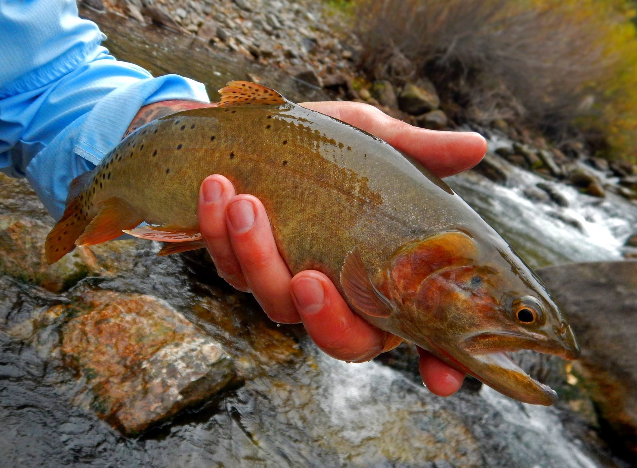 Cutthroat Trout on the Logan River, Copyright (c) Chadd VanZanten, Photographer