SNOTEL Snowpack Recording Stations

Manual Snow Measurement
Cover image from
Snow surveying by James C. Marr
USDA 1940 Publication 380
Public Domain
Courtesy UVA, Google & HathiTrust

For a modern view visit
https://www.meted.ucar.edu/afwa
/avalanche/print.htm
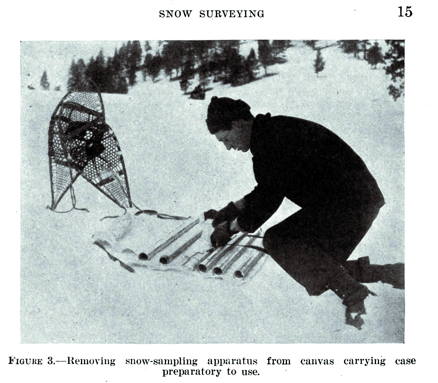
Removing snow surveying apparatus
from canvas carrying case
preparatory to use
From
Snow surveying by James C. Marr
USDA 1940 Publication 380
Public Domain
Courtesy UVA, Google & HathiTrust

Water is a precious resource throughout the world. Most of Utah consists of arid habitats and many users clamor for their share of the scarce moisture. Ever-growing demand challenges water managers to insure that agriculture, cities and nature all get their portion. Predicting and monitoring stream flow is imperative in order to know how much to hold in reservoirs or send downstream, and when to anticipate floods, enact water conservation measures, and in general provide for all users.

Much of Utah’s water originates in the mountain snowpack. Early in the twentieth century, the Department of Agriculture constructed a series of Snow Courses in mountainous areas of the West. Hardy personnel periodically trekked in to measure snow depth with a long ruled stick. Water content was found by taking a core sample, weighing it and subtracting out the weight of the metal tube. Stream gauging stations installed by the US Geological Survey allowed correlation of stream flows with snowpack measures.

In the 1970’s, monitoring snow courses became more automated. The reporting stations were named “SNOTEL” for snowpack telemetry. Now there are over 600 SNOTEL sites in 13 western states. The measurement functions of SNOTEL stations are elegantly simple and reliable. Air and soil temperatures are monitored with standard thermocouples. Water content of the snowpack is measured by its weight atop a broad thin bladder called a snow pillow that is filled with antifreeze. The snow pillow is carefully spread on the ground. Accumulating snow presses down on the pillow, pushing some antifreeze out a connecting tube to a pressure sensor.

Some SNOTEL sites also measure snow depth, using the autofocus technology of the digital camera. Subject distance is gauged by the time delay of an ultrasonic pulse, like sonar or hearing your voice echo back in a canyon. At a SNOTEL station, a similar sensor is placed high above the expected snow line. As snow accumulates, the downward facing sensor reports the shortening distance between it and the snow surface.

SNOTEL stations have batteries and a solar panel to power their hourly data transmissions. Ogden has one of the two master receiving stations. Want to size up mountain snowfall from the last storm or know how warmly to dress for an outing? Just go to Utah’s SNOTEL information site on the web.

Credits:

Image: Public Domain, Courtesy University of Virginia, Google and HathiTrust, Cover image from Snow surveying by James C. Marr, USDA 1940 Publication 380
Theme Music: Written by Don Anderson and performed by Leaping Lulu from their CD “High Road, Low Road”
Text: Jim Cane & Linda Kervin, Bridgerland Audubon Society https://www.bridgerlandaudubon.org
Voice: Linda Kervin, Bridgerland Audubon Society https://www.bridgerlandaudubon.org
Additional Reading:

Water Conservation Begins with Snow Surveys, USDA NRCS, https://www.wcc.nrcs.usda.gov/factpub/wc_ss.html

Snow Hydrology: SNOTEL, Randall Julander, Civil & Environmental Engineering, University of Utah, (formerly at https://www.civil.utah.edu/~cv5450/snotel/snotel.htm)

Utah Snow Survey Program, USDA NRCS, https://www.ut.nrcs.usda.gov/snow/

NRCS Snow Surveyor Collects Vital Water Data, Lives Dream Job, Spencer Miller, NRCS, Jan 10, 2013, https://www.nrcs.usda.gov/wps/portal/nrcs/detail/national/home/?cid=STELPRDB1076993

Snow Surveys and Water Supply Forecasting, National Atlas of the United States, US Department of the Interior, formerly at https://www.wcc.nrcs.usda.gov/factpub/sect_4a.html

Utah Snow Survey Program, Natural Resources Conservation Service, US Department of the Interior, https://www.nrcs.usda.gov/utah/snow-survey

Map, Utah USGS SNOTEL Stations https://www.wcc.nrcs.usda.gov/snotel/Utah/utah.html

Properties of Water

Click for a larger view of water as frost on a window, Courtesy and Copyright Andrea Liberatore
Water as frost on a window
Courtesy and © Andrea Liberatore

Click for a larger view of water surface tension on a quarter, Courtesy and Copyright Andrea LiberatoreSurface tension – water drops
on a quarter
Courtesy and © Andrea Liberatore

Click for a larger view of water as snowflakes, Courtesy and Copyright Andrea LiberatoreWater as snowflakes
Courtesy and © Andrea Liberatore

In our winter wonderland, water is all around. It piles upon the landscape in great white drifts. It is a substance life is completely dependent upon and as ordinary as it seems, this tasteless, odorless substance is actually quite amazing. Up to 60% of our body mass is due to water, and life as we know it would not exist if not for water’s unique physical properties.

When most known liquids get colder they contract – shrinking around 10 percent in total volume. Water contracts too, but only until it reaches its freezing point, at which time it reverses course and begins to expand. This molecular marvel does wonderful things for life on earth. As water freezes and expands, the resulting ice becomes lighter than its liquid form, causing it to float. If ice contracted as other liquids do, it would sink, and lakes would freeze from the bottom up – and freeze quickly, meaning big changes for aquatic life. Water in all forms happens to be a very good insulator, meaning that it doesn’t change temperature very quickly. Ice floating on top of a pond insulates the water underneath, keeping it warmer, and therefore liquid, longer than it normally would. Obviously this is beneficial for local creatures like fish and beavers not to mention the penguins, whales and seals that thrive in the colder parts of our planet.

Another critical property of water is its stickiness. Individual molecules are generally more attracted to each other than to other substances such as air or soil. This ‘stickiness’, or cohesion, creates surface tension, which allow puddles, rivers, and raindrops to form, and also enables water striders to glide on the water’s surface and rocks to skip across a lake. Water tension is also responsible for a tree’s ability to siphon water from the soil and transport it to the very topmost leaf. However water’s bonds aren’t so strong as to be unable to break when a fish swims through or when you cannonball into the deep end. You can observe surface tension at home by dripping water onto the head of a coin, and watching it ball up into a surprisingly large mound.

Water is also one of the only known substances that naturally occurs in three phases – solid, liquid, and gas. This is important to many facets of life including the proper functioning of the weather system as we know it. Thankfully, there is a lot of water here on earth – about 320 million cubic miles of it. However, only four tenths of a percent of that comes in the form of freshwater lakes & rivers. Most of the rest is locked up in glaciers and oceans. It’s also important to realize that this is all of the water that Earth has ever had, and all the water we’re ever going to get, which can lead to some interesting thoughts about where that water you are about to drink has previously been. Perhaps it was once part of Lake Bonneville, in the snow that fell on the back of a wooly mammoth, or in a puddle slurped up by a brachiosaurus. If only water could talk…

For more sources and to calculate your water-use footprint, visit our website at www.wildaboututah.org.

For the Stokes Nature Center and Wild About Utah, this is Andrea Liberatore.

Credits:

Images:  Andrea Liberatore, Stokes Nature Center in Logan Canyon.

Text:     Andrea Liberatore, Stokes Nature Center in Logan Canyon.


Additional Reading:

Bryson, Bill (2004) A Short History of Nearly Everything. Broadway (Random House): New York.

U.S. Geological Survey (2013) The USGS Water Science School. Accessible online at: https://ga.water.usgs.gov/edu/

United Nations: Water. Accessible online at https://www.unwater.org/

Calculate your water footprint:
https://www.waterfootprint.org/?page=files/YourWaterFootprint


From Flood to Fire, Utah’s evolving role in mending rangelands

From Flood to Fire, Utah’s evolving role in mending rangelands: Click for a larger view of , Utah.  Courtesy and Copyright 2012 Jim Cane, Photographer
Blue flowers of wild flax
years after seeding
of Devil’s Playground.
Courtesy & Copyright 2012
Jim Cane, Photographer

From Flood to Fire, Utah’s evolving role in mending rangelands: Click for a larger view of Native grasses established two years after seeding Scooby Fire., Utah.  Courtesy and Copyright 2012 Jim Cane, PhotographerNative grasses established
two years after
seeding Scooby Fire.
Courtesy & Copyright 2012
Jim Cane, Photographer

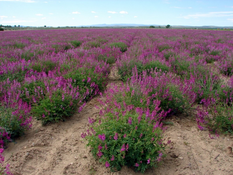
From Flood to Fire, Utah’s evolving role in mending rangelands: Click for a larger view of , Utah.  Courtesy and Copyright 2012 Jim Cane, PhotographerNative sweetvetch farmed
for seed production.
Courtesy & Copyright 2012
Jim Cane, Photographer

Restoring degraded plant communities has a long history on Utah’s public lands. The problem began with the transcontinental railroad, which enabled transport of livestock from Western rangelands to Eastern cities. By the late 1800s, vast flocks of ravenous sheep roved Utah’s unregulated wildlands. Montane summer pastures were stripped bare, so snow melt and summer rainfall washed across the ground unchecked, carving deep gullies. Downstream settlements, such as Logan and Manti, incurred ruinous floods and mud flows. Teddy Roosevelt responded to local pleas for federal control by designating our first national forests in Utah.

Soon thereafter, the fledgling Forest Service created the Great Basin Research Station east of Ephraim Utah. It was charged with discovering the cause of the floods. Within two years, large grazing exclosures were built in nearby mountain meadows by the Agency’s first range ecologist, Arthur Sampson. His research quickly linked overgrazing with denuded meadows, eroding soil and the floods. By 1914, Sampson advocated for rest rotational grazing. To then restore the impacted plant communities, there followed a landmark program at the Station to evaluate plants that could revegetate the degraded watersheds, and later, restore big-game winter range. Led by Perry Plummer, the Station evaluated the performance of 1000 species of shrubs, grasses and wildflowers, some tested in most of Utah’s plant communities. Methods to better collect, store, plant and germinate seeds underpinned the restoration of plant communities that, along with the 1934 Taylor Grazing Act, ended Utah’s frequent canyon floods.

That public research continues with the Great Basin Native Seed Selection and Increase Project. Today’s goal is to restore plant communities after rangeland fire, stalling and eventually reversing the invasion of flammable exotic grasses and weeds in the Intermountain West. Dedicated warehouses in Ephraim, Ely and Boise can store up to 3 million pounds of seed, a testimony to further progress in farming and collecting desirable seed. The seed is spread by aircraft over rocky places, while on gentler slopes, versatile rangeland seeders can place each kind of seed at the right depth, from tiny sagebrush to big grass seeds, all in a single pass over uneven ground. For every planting that takes hold, another weedy legacy of hundred-year-old overgrazing is finally repaired.

This is Linda Kervin for Bridgerland Audubon Society.

Credits:

Images: Courtesy & Copyright Jim Cane
Text: Jim Cane, Bridgerland Audubon Society

Additional Reading:

https://wildfiretoday.com/page/2/

https://www.fs.fed.us/rm/boise/research/shrub/greatbasin.shtml

https://www.fs.fed.us/rm/boise/research/shrub/projects/plant_guides.html

Reseeding the West After Fire

Reseeding the West After Fire
Soil bared by fire with
furrows left by new seeding.
Devil’s Playground Fire, Box Elder Co.
Courtesy & Copyright 2012
Nancy Shaw, Photographer

Reseeding the West After FireBlue flowers of wild flax
years after seeding
of Devil’s Playground.
Courtesy & Copyright 2012
Jim Cane, Photographer

Reseeding the West After FireSeed being planted after fire
using a rangeland drill.
Scooby Fire, Box Elder Co.
Courtesy & Copyright 2012
Nancy Shaw, Photographer

Reseeding the West After FireNative grasses established
two years after
seeding Scooby Fire.
Courtesy & Copyright 2012
Jim Cane, Photographer

Native sweetvetch farmed
for seed production.
Courtesy & Copyright 2012
Jim Cane, Photographer

Palmer penstemon farmed
for seed production.
Courtesy & Copyright 2012
Bob Hammon, Photographer

More than 7 million acres burned this summer across the western United States. It’s the biggest fire year since 2007. In Utah, wildfires blazed across 450,000 acres, as much land as the urbanized Wasatch front. Most of these fires scorched basin and foothill habitats dominated by sagebrush or juniper forests. After a year or two, the blackened land will turn green. But shrubs and trees in these basin habitats are frequently killed by fire. Where these native plant communities naturally recover, it’s because perennial wildflowers and grasses resprout, and, like the shrubs, germinate their seeds. However, overgrazing a century ago impoverished many western rangelands. Aggressive weeds from Europe and Asia could then invade, such as tumblemustard, Russian thistle, and red brome or cheatgrass. These weeds outcompete our natives, multiplying with each fire cycle to eventually carpet the landscape.

To stem this tide of weed invasion after fire, land managers assist plant community recovery by planting mixtures of shrub, grass and wildflower seed. The shrub seed is mostly native, harvested from the wild by private seed collectors. The tiny seeds of several kinds of sagebrush prevail, often mixed with fourwing saltbush, shadscale, or bitterbrush.

The grasses are largely farmed by specialty growers. In past decades, these were mostly tough, competitive grasses from the Asian steppe, notably crested and tall wheatgrasses, and Russian wildrye. These practical, affordable grasses stand up to cheatgrass, but they also impede the return of the native flora. Today, half the grass seed applied after Great Basin fires includes natives, such as Sandberg bluegrass, squirreltail, Indian ricegrass, and bluebunch wheatgrass.

Use of wildflower seed has lagged. It’s challenging to farm yet costly to wild harvest. Today, a handful of innovative farmers are growing native wildflowers for seed, such as yarrow, Lewis flax, sweetvetch, two prairie-clovers, a milkvetch, and several penstemons. How much seed is needed? After the big fire year of 2007, four thousand tons of shrub, grass and wildflower seed were planted in the American West!

This is Linda Kervin for Bridgerland Audubon Society.

Credits:

Images: Courtesy & Copyright Nancy Shaw
            Courtesy & Copyright Bob Hammon and
            Courtesy & Copyright Jim Cane
Text: Jim Cane, Bridgerland Audubon Society

Additional Reading:

https://wildfiretoday.com/page/2/

https://www.fs.fed.us/rm/boise/research
/shrub/greatbasin.shtml

https://www.fs.fed.us/rm/boise/research/shrub
/projects/plant_guides.html

Forero, Leslie, Plants Surviving Cheatgrass Invasion May Improve Restoration Chances, Study Shows, UPR Utah Public Radio, Feb 26, 2018 https://www.upr.org/post/plants-surviving-cheatgrass-invasion-may-improve-restoration-chances-study-shows