Sage Steppe

Mountain big sagebrush (Artemisia tridentata subsp. Vaseyana) in flower - Photo Courtesy and Copyright Dr. Leila Shultz
Mountain big sagebrush (Artemisia tridentata subsp. Vaseyana) in flower – Photo Courtesy and Copyright Dr. Leila Shultz

Three-tip sage (Artemisia tripartite) with visible yellow flowers. - Photo Courtesy and Copyright Dr. Leila ShultzThree-tip sage (Artemisia tripartite) with visible yellow flowers. – Photo Courtesy and Copyright Dr. Leila Shultz

Zane Gray’s “Riders of the Purple Sage” and Steve Tremble’s “Sage Brush Ocean” are book titles that may invoke excitement from your literary past. Or you may be traveling along the interstates and side roads of our great state as monotony sets in and drowsiness tightens your grip on the wheel while you nod your way through endless miles of this seemingly drab landscape.

In science jargon it’s referred to as sage steppe, the dominant landscape throughout much of Utah and the Great Basin. Much of this maligned biotic community has been degraded or lost through various mismanagement practices. Sage Steppe is considered an endangered ecosystem despite the seemingly large area it inhabits, primarily due to fragmentation. And the iconic Gunnison sage grouse has followed its demise having recently been placed on the threatened species list.
I just returned from spending a day of study in the field with 16 college students running transects for the Grand Teton N.P. The park is spending millions in sage steppe restoration work to reclaim this critical plant community.

Sagebrush is an important member of an ecosystem that helps support many birds, reptiles, amphibians, and mammals, as well as an abundance of insects and microbes. One study found nearly 300 arthropod species directly living on just a few plants including- 72 spider, 237 insect, 42 of which were gall-forming, amongst many other species. Such diversity also indicates that sage is playing an important part in maintaining the health of the environment providing ecosystem services such as soil protection, water conservation and nutrient cycling.
Sage is well adapted to the demands of semi-arid deserts. It has tap roots that can go over 15 feet deep to suck up any ground water that might exist and forms extensive webs of surface roots in association with symbiotic fungal hyphae to efficiently gather any rain that might fall. Oftentimes, sagebrush grows in clonal communities with members that can live over 100 years!

Aromatic odors emanating from sage, especially following a downpour of rain, comes from a mix of chemicals including camphor, terpenoids, and a cocktail of other volatile compounds. Some of the chemicals have anti-herbivory action by killing the gut bacteria of carious browsers although pronghorn antelope seem to have evolved resistance to these toxins. Other browsers like cattle, sheep, and mule deer can only eat sagebrush in small doses or whan the leaves are young and tender.

It is this mixture of molecules that sagebrush produces which come into play for communication. Sagebrush is eaten by many mammals and insects. When sagebrush is browsed on by a pronghorn or grasshopper volatile compounds are released from the wound that warn other branches of the same sagebrush as well as the neighboring sage about the potential threat. The sagebrush in the area react to the warning by metabolizing toxins that make them taste unappealing and that cause digestive discomfort for future herbivores who try to make a meal of them.

Native Americans considered sage a sacred plant. It offered medicine, clothing, shelter, and was commonly used in their ceremonial sweat lodges. Last but not least, my lovely granddaughter was given the name Sage. So the next time you find yourself surrounded by our “sagebrush ocean” pay tribute to this vibrant and intricate community of life.

Jack Greene, a lover of sagebrush.

Credits:

Pictures: Courtesy and Copyright Dr. Leila Shultz
Text: Jack Greene, Bridgerland Audubon Society

Additional Reading:

The Geology of Canyonlands National Park

Chesler Park
Canyonlands National Park
Photo Courtesy and Copyright Kurt Repanshek, Photographer

Chesler Park
Canyonlands National Park
Photo Courtesy and Copyright Kurt Repanshek, Photographer

Baked by time like some multi-layer geologic tort, Canyonlands National Park in southeastern Utah features a landscape cut by canyons, rumpled by upthrusts, dimpled by grabens, and even pockmarked, some believe, by ancient asteroids.

Just outside of Moab rises a kaleidoscope of tilted and carved geology laid down over the eons. There’s the red and white Cedar Mesa sandstone, the grayish-green Morrison Formation, pinkish Entrada sandstone, and tawny Navajo sandstone, just to name some of the geologic layers. Stacked like pancakes, they help make Canyonlands the most rugged national park in the Southwest and, quite possibly, if you find yourself deep in the park’s Maze District, in the entire Lower 48 states.

In each of the park’s districts — Island in the Sky, Needles, Maze and Horseshoe Canyon — the remarkable effects of geologic time and its endless erosion on this sedimentary landscape rise about you.

If you could turn back the geologic clock, you would see the landscape flooded by oceans, crisscrossed by rivers, covered by mudflats and buried by sand. At various times through the millennia, the climate has resembled a tropical coast, an interior desert, and everything in between.

For hundreds of millions of years, material was deposited. Layer upon layer of sedimentary rock formed as buried materials were cemented by precipitates in the ground water. Each layer contains clues to its origin, such as patterns or fossils, which reveals the environment when it was deposited. For example, the colorful Cedar Mesa Sandstone occurred when periodic floods of iron-rich debris from nearby mountains inundated coastal dunes of white sand.

Along with sedimentation, movements in the earth’s crust altered surface features. The North American continent migrated north from the equator and the local climate and environment here changed dramatically.

Peer into the ragged maw of Canyonlands from the Island in the Sky District on the northern end of the park, and it’s no mystery how the park came by its name.

Spend the night at the Squaw Flat Campground in the Needles District and a morning hike into Chesler Park surrounds you with Creamsicle-hued minarets towering high above, like a king’s crown.

Though Canyonlands covers less than 350,000 acres, which is less than one-seventh the size of Yellowstone National Park, it feels much larger. No doubt it’s the park’s vastness and openness — you won’t find any forests here. Indeed, one old timer said that, “On a clear day, you can see the back of your own head.”

Spend a few minutes contemplating the natural forces, and the hundreds of millions of years that laid down these sediments and compressed these layers of rock. It’s really only recently that these layers have eroded to form the remarkable landscape seen today in Canyonlands National Park.

For Wild About Utah and National Parks Traveler, I’m Kurt Repanshek.

Credits:
Image: Courtesy and Copyright Kurt Repanshek, www.nationalparkstraveler.com
Text:     Kurt Repanshek, NationalParksTraveler.com.


Additional Reading:

Canyonlands National Park, National Parks Service,

Exploring The Parks: Musings From Island In The Sky At Canyonlands National Park, NationalParksTraveler.com Article – Lee Dalton – 06/24/2014

Exploring The Parks: Musings From The Needles District In Canyonlands National Park, NationalParksTraveler.com Article – Lee Dalton – 06/19/2014

Reflections Of Time In Canyonlands, NationalParksTraveler.com Article – Lee Dalton – 06/19/2014

https://www.nationalparkstraveler.com/search/apachesolr_search/canyonlands, NationalParksTraveler.com Canyonlands Articles

Hylland, Rebecca, What are Igneous, Sedimentary & Metamorphic Rocks?, Glad You Asked, Utah Geological Survey, https://geology.utah.gov/map-pub/survey-notes/glad-you-asked/igneous-sedimentary-metamorphic-rocks/

The Cutthroat Trout-A Utah Native

The Cutthroat Trout-a Local Favorite: Yellowstone Cutthroat Trout, Oncorhynchus clarki bouvieri
Yellowstone Cutthroat Trout
Oncorhynchus clarki bouvieri
Courtesy USDA Forest Service
 
Cutthroat Trout A “no-trouts-land” on the Logan River, Copyright (c) Chadd VanZanten, Photographer vanzanten-cutthroat_trout 
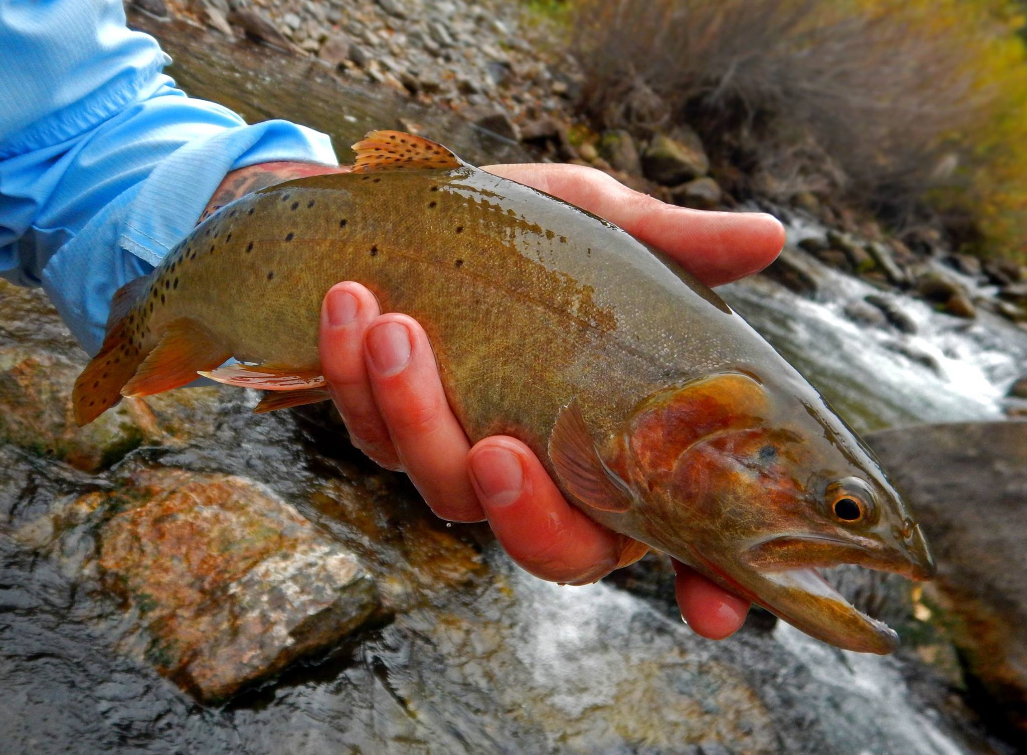
Cutthroat Trout on the Logan River, Copyright (c) Chadd VanZanten, Photographer
 
Colorado River Cutthroat Trout, Oncorhynchus clarki pleuriticusColorado River Cutthroat Trout
Oncorhynchus clarki pleuriticus
Courtesy US BLM Rawlins, WY Office
 
Utah streams offer excellent year-round fishing opportunities for every level of angler. According to the Department of Natural Resources, Utah’s waters are home to approximately 80 different species of fish, but it is the trout fishing that is the biggest attraction for fishermen. Of the trout species swimming in our rivers and lakes, the cutthroat trout is a local favorite and the only trout native to the state.

The cutthroat trout represents the most diverse trout species in North America. They are a freshwater fish of the Salmonidae family that live in cold, clear streams and lakes across the west. Cutthroat trout are distinguished from other trout species by two red slashes prominently striping the lower jaw after which they are named. All cutthroat trout share a single common ancestor, but historic population isolation gave rise to 14 subspecies, each endemic to their own geographic region and river drainage.

There are four subspecies that exist in Utah. Only three of these are considered native to the state: the Colorado River cutthroat, the Yellowstone cutthroat, and Utah’s state fish, the Bonneville cutthroat. In Utah, the Colorado River cutthroat trout can be found in some of the smaller streams and tributaries of the Green River, the San Juan River, and the Colorado River drainages. Their bright coloration and posterior black spotting distinguish these cutthroats from others.

Pure, native Yellowstone cutthroat trout are present in small numbers in the streams of the North Slope of the Raft River Mountains in northwestern Utah. However, this subspecies is more widely distributed across the state due to extensive stocking. Yellowstone cutthroat trout can be differentiated by larger-sized black spots concentrated near the tail and their gold, gray, and copper tones.

The Bonneville cutthroat trout evolved in the Bonneville Basin of Utah, Wyoming, Idaho, and Nevada. Its primary ancestors were a population of lake dwelling cutthroat trout living in the late-Pleistocene aged Lake Bonneville. The Bonneville cutthroat trout is less vividly colored and has spots that are more sparsely and evenly distributed across the body than other cutthroats. Thought to be extinct in the 1970s, populations of the Bonneville cutthroat trout are now estimated to exist in around 35% of their historic range, including the nearby Weber and Provo Rivers.

Like so many species, the native cutthroat trout of Utah are under significant pressure due to drought, habitat loss, disease, and competition with non-native species. Though only the Colorado River cutthroat is included on the Utah State Sensitive species list, conservation of all of Utah’s native cutthroat populations is a focal point for state wildlife resource managers.

For Wild About Utah, I’m Anna Bengtson of Park City.

The Cutthroat Trout-a Local Favorite-Credits:
Images: Courtesy USDA Forest Service, US Bureau of Land Management & Chadd VanZanten.
Text: Anna Bengston

Additional Reading:

Anna Bengston’s Postings on Wild About Utah, https://wildaboututah.org/author/anna-bengston/

Utah Fishing Regulations, Utah Division of Wildlife Resources, Department of Natural Resources, State of Utah, https://wildlife.utah.gov/fishing/fishing-regulations.html.

Fishes, Utah Division of Wildlife Resources, n.d. Web. 7 July 2014: https://fieldguide.wildlife.utah.gov/?class=actinopterygii.

Bonneville Cutthroat Trout, Utah Species, Utah Division of Wildlife Resources, Department of Natural Resources, State of Utah, https://fieldguide.wildlife.utah.gov/?species=oncorhynchus%20clarkii%20utah

Colorado River Cutthroat Trout,, Utah Species, Utah Division of Wildlife Resources, Department of Natural Resources, State of Utah, https://fieldguide.wildlife.utah.gov/?species=oncorhynchus%20clarkii%20pleuriticus.

Yellowstone Cutthroat Trout, Utah Species, Utah Division of Wildlife Resources, Department of Natural Resources, State of Utah, https://fieldguide.wildlife.utah.gov/?species=oncorhynchus%20clarkii%20bouvieri

Greenback Cutthroat Trout, Western Native Trout, https://www.westerntrout.org/gc-trout.html.

Cutthroat Trout, Colorado Parks and Wildlife, https://cpw.state.co.us/learn/Pages/ResearchCutthroatTrout.aspx.

Cutthroat Trout (Oncorhynchus clarkii) – FactSheet. Cutthroat Trout (Oncorhynchus clarkii) – FactSheet. U.S Geological Survey, 14 June 2013. Web. 7 July 2014: https://nas.er.usgs.gov/queries/FactSheet.aspx?speciesID=890.

Bonneville cutthroat trout (Oncorhynchus clarki utah), U.S. Fish & Wildlife Service, US Department of the Interior, https://www.fws.gov/species/bonneville-cutthroat-trout-oncorhynchus-clarkii-utah

Brown, Dylan. Shocking habitat projects help increase native Cutthroat populations. Standard Examiner, 14 May 2014. Web. 7 July 2014: https://www.standard.net/lifestyle/recreation/2014/may/13/shocking-habitat-projects-help-increase-native-cutthroat-populations/.

Chorney, Chad. For the Love of Cutthroat Trout Unlimited Blog, 29 Jan. 2013. Web. 7 July 2014: https://westslope.tu.org/comment/1556.

An Arizona Road Trip Back Into the Past

Montezuma Castle, Courtesy US NPS
Montezuma Castle
Courtesy US NPS
 
Location of Hubbell Trading Post NHS in the Southern Colorado Plateau Network,  Courtesy US NPSLocation of Hubbell Trading Post NHS in the Southern Colorado Plateau Network
Courtesy US NPS
 
Hubbell Trading Post, Courtesy US NPSHubbell Trading Post Interior
Courtesy US NPS

Arizona is rich in history — from the 1800s all the way back to the Late Triassic Period. You can stitch together a road trip that winds out of Flagstaff to Montezuma Castle National Monument, to Petrified Forest National Park, and ends at Hubbell Trading Post National Historic Site. Along the way you’ll experience fascinating chapters of geologic and cultural history.

At Montezuma Castle, 45 minutes south of Flagstaff and just off Interstate 17 (Exit 289), a short walk places you in front of a 5-story-tall cliff dwelling that offered safety from invaders: it stands 100 feet above the valley floor, nestled into an alcove.

The site was misnamed Montezuma Castle in the late 1800s by whites who thought the structure had been built by the Aztec people. The original owners, members of the Southern Sinagua (seen aug wah) people, called this area home from roughly 1100-1425 A.D.

Stroll the short trail that loops around a vegetated landscape below the “castle,” and you’ll find great views as well of the remains of Castle A. That dwelling once rose 60 feet and was home to about 100 residents.

From Montezuma’s Castle, it’s 95 miles via Arizona 87 to Winslow, and then 34 miles east on Interstate 40 to Holbrook. Finally, another 19 miles southeast on Arizona 180 leads you into Petrified Forest National Park and its unusual landscape.

There’s no lodging within the park, and you have to leave by sundown, so you will need to make some tough decisions if you have just one day. Do you take time to tour the Rainbow Forest Museum with its dinosaur displays, or hike out to Agate House?

A building built of petrified wood is pretty cool, so stretch your legs with a walk to the house. Then head north and deeper into the park to the Crystal Forest Trail. Wander this path and you’ll find yourself surrounded by petrified wood with its hues of yellow, red, and green, black and white.

Blue Mesa is another great stop. There’s a trail that takes you down into another colorful landscape of badlands and chunks, logs, and even slabs of petrified wood in shades of red, blue, yellow and black.

The northern end of the park road is anchored by the Painted Desert, a great place for sunset photos. Here you’ll also see the Painted Desert Inn, which some day could put the Park Service back into the lodging business but today is just a museum piece.

Back on Interstate 40, drive 22 miles east to Chambers, and then north on U.S. 191 for about 38 miles to Ganado and Hubbell Trading Post. This authentic trading post was opened by John Lorenzo Hubbell in 1878 on the Navajo Reservation.

Although it was added to the National Park System in 1967, Hubbell is not a museum piece but an active trading post. As such, it still holds richly woven Navajo rugs, jewelry, and other Native American artworks for purchase.

Schedule your visit to Hubbell Trading Post for May and you just might be able to attend the annual Native American Art Auction. Check with the park (928-755-3475) for the exact date.

If you have a little more free time, you could extend your your trip by heading 39 miles north on 191 to Canyon de Chelly National Monument.

For Wild About Utah and National Parks Traveler, I’m Kurt Repanshek.

Credits:
Image: Courtesy and Copyright Kurt Repanshek, www.nationalparkstraveler.com
Text:     Kurt Repanshek, NationalParksTraveler.com.

Additional Reading:

Montezuma Castle National Monument, NationalParksTraveler.com, https://www.nationalparkstraveler.com/2012/03/visiting-montezuma-castle-national-monument-arizona9636

Montezuma Castle National Monument, US National Park Service, https://www.nps.gov/moca/index.htm

Geographic Area covered by the State of Deseret and Utah Territory, International Society Daughters of Utah Pioneers, https://www.dupinternational.org/dyn_page.php?pageID=54