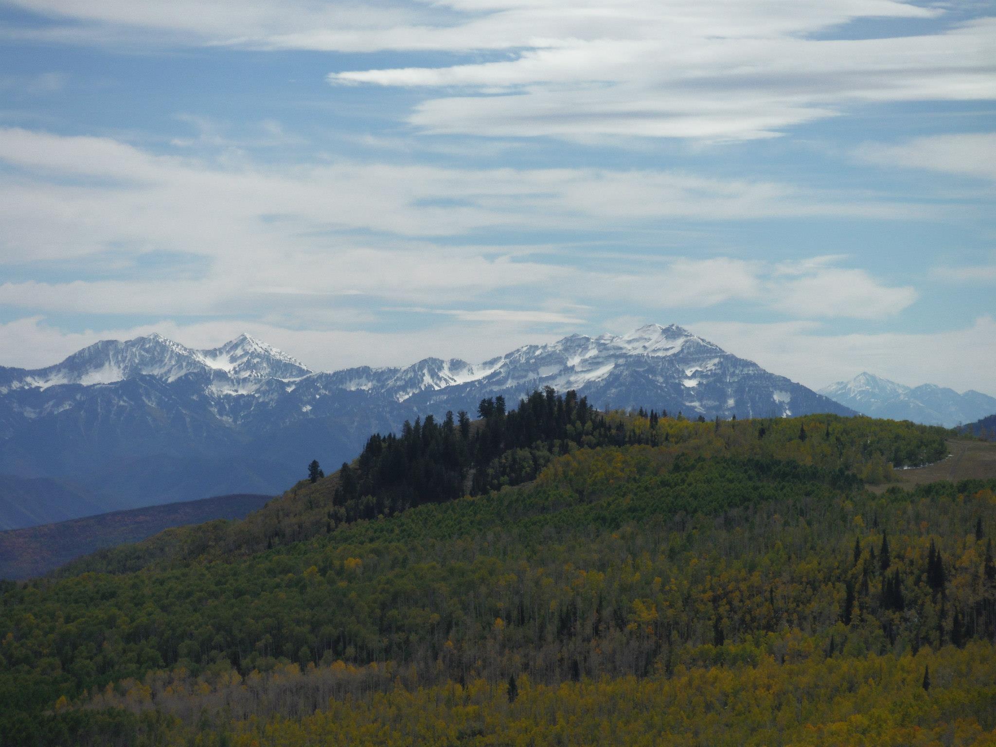
Up a Fork in the Cache National Forest

Up a Fork in the Cache National Forest: Cache National Forest Courtesy & © Patrick Kelly, Stokes Nature Center https://logannature.org
Cache National Forest
Courtesy & © Patrick Kelly, Stokes Nature Center
https://logannature.org
There’s a place I like to walk, when I don’t know where else to go, up a Fork in the Cache National Forest.
It’s got all that I want, and all my dog needs: good views and plenty of fast clear water.Up a Fork in the Cache National Forest

It starts off hot and dry, breaks you in quick, but soon the sun’s not so bad.
Walking along the way, helps my mind stray, and soak up right where I am.

The office, the traffic, the honey-dos and the chores all slip freely from my mind,
As I watch my dog sprint, over gentian and mint, and love being as free as the wild.

Being out there and free, helps me think and see, that I’m a part of instead of apart from,
This beautiful world, full of imperfect others, that with time are revealed as imperfect Thous.

This world, this here, this beautiful now, I choose and choose nowhen else,
Because today I see beavers, and grasshoppers, and eagles, and get to wonder when the ducks will again fly south.

My dog and I continue, to hike along the trail, until we come to the Cottonwood Graveyard,
There we stop, maybe stay, for a while and a bit, and she swims after sticks thrown in ponds.

After she’s had a cooldown, we keep hiking uptrail, into the thick of evergreen scents,
My calves start mooing, and my dog she keeps zooming, a bobsledder hot in the chute.

When the trees do break, and the land opens again, we cross the river one last time,
It brings us into a place, folks once knew back in the day, as the sawmill with the best oxen in town.

Me and my dog, we’ll linger there for a minute, and I’ll think how happy we are,
That this place was here, but isn’t any longer, or else the boon would not be worth the trial.

On our way back to the car, it’s hard work to keep your mind far, from the valley to-dos in the not far ahead,
But I remember why, I take the time to get out under the sky, in the wild to clear my over-civilized head:

You can bring a horse to water, but you can’t make him drink, but he also can’t drink unless he’s at that trough.
So even if today’s got you feeling astray, remember there’s good liquid if you’d like it not too far off.

So go out today, or tomorrow or Thursday, make it a formal appointment if it’ll keep you true,
Doesn’t matter the place, as long as there’s space, to keep an eye out for the moments which pull the awe to you.

And when you find them, because if you look hard you will, take a minute and breathe in the crackling air’s hum.
And remember that smell, and keep it deep in your heart, because that’s the wild wind that makes all it and us one.

I’m Patrick Kelly and I’m Wild About Utah
 
Credits:

Images: Image Courtesy & Copyright © Patrick Kelly, Photographer
Audio: Contains audio Courtesy & Copyright Friend Weller, J. Chase and K.W. Baldwin
Text:    Patrick Kelly, Director of Education, Stokes Nature Center, https://logannature.org
Included Links: Lyle Bingham, Webmaster, WildAboutUtah.org

Additional Reading

Ohms, Sarah, Bridgerland Audubon Society, Logan Canyon Hiking, https://LoganCanyonHiking.com/

The Allen & Alice Stokes Nature Center, https://logannature.org
Included Links: Lyle Bingham, Webmaster, WildAboutUtah.org

Kelly, Patrick, In the Eyes of a Bear, Wild About Utah, July 27, 2020 https://wildaboututah.org/in-the-eyes-of-a-bear/

Imaginary Wanderings

Imaginary Wanderings: The edge of the Great Basin, top of the Bear River Range Courtesy & Copyright Josh Boling, Photographer
The edge of the Great Basin, top of the Bear River Range
Courtesy & Copyright Josh Boling, Photographer
I’ve fancied a certain type of wandering lately—to grab my pack and boots and walk the lines of Utah’s political border—a trail made not of dirt and stone, but of imaginary lines of latitude and longitude. But, as of yet, I haven’t found the time or resources to do so beyond my own imagination and the 3 or 4 minutes I have with you now. Come join me in a stroll around Utah, at least the way I’ve imagined it.

Walking north out of Logan, I’ll wander through the grid-patterned neighborhoods that pepper the flanks of the Bear River Range, the still-snowy peaks that serve as sentinels over my daily commute and the adventure on which I embark now. They serve another, greater purpose, too, though. Without the Bear Rivers, the Rocky Mountains would be otherwise dissected. The snowy peaks I adore and which now pass in slow motion over my right shoulder form the only range of mountains that connect the northern and southern Rockies. Though they only measure about 70 miles in length, they provide a critical ecological thoroughfare from the south end of Cache Valley, Utah, north to Soda Springs, Idaho.

I won’t follow them that far, though. I’ll turn left (west) at the Idaho border toward the Great Basin.

I’m technically already there. We all are if we live along the Wasatch Front. And there are just a few minor ranges—the Clarkston Range, Blue Spring Hills, and the northern fingerling ridges of the Promontory Mountains—to wander across before reaching the Great Basin proper.

My favorite hidden gem of this often-overlooked portion of Utah are the Raft River Mountains. Like the mighty Uintas to the east, the Raft Rivers run East-to-West. So, despite being a stone’s throw from the Great Salt Lake, the tributaries running off their northern flanks drain not into the Great Basin and the Great Salt Lake, but north onto the Snake River Plain toward the Columbia River and, eventually, the Pacific Ocean.

The Tri Corners Landmark is a simple granite pillar sticking 3 or 4 feet out of the sand amongst wind-whipped sage brush. It’s easy to miss, but marks some interesting irregularities. Utah’s political border is not, in fact, made up of straight lines. According to cartographer Dave Cook, surveyors who created the state’s initial boundaries hastily covered ground with their crude survey instruments. They were paid by the mile, so they were more interested in finishing quickly than correcting any errors they made along the way.

The border wiggles at least four times by my calculations—one of which comprises two right angles—as it wanders across ridgelines and through the dusty draws of the basin and range mountains toward the Mojave Desert of southwest Utah.

Imaginary Wanderings: The wrinkled topography if the Colorado Plateau Courtesy & Copyright Josh Boling, Photographer
The wrinkled topography if the Colorado Plateau
Courtesy & Copyright Josh Boling, Photographer
I won’t be there for long, though. The border only runs for roughly 50 miles along the two legs of the right triangle that constitutes Utah’s allotment of the Mojave Desert before it climbs up onto the Colorado plateau. Ed Abbey famously compared the wrinkled topography of Utah, particularly his beloved canyon country of the Colorado Plateau, to the two largest of our states. “Alaska is our biggest, buggiest, boggiest state,” Abbey wrote. “Texas remains our largest unfrozen state. But mountainous Utah, if ironed out flat, would take up more space on a map than either.” Ropes, technical climbing and canyoneering gear, and a fair amount of fortitude would be required here.

The eastern border we share with Colorado is a varied expanse of high desert plateaus, rugged cliffs, out-of-place riparian zones, and a few spectacular snow-capped mountain ranges leading through some of the most beautiful and gloriously desolate places on the planet. The Book Cliffs, Dinosaur National Monument, and the La Sal Mountains come to mind.

A short walk distance-wise would require heaps of route finding across the Green River’s Flaming Gorge and along the northern toes of the Uinta Mountains. Here is perhaps the greatest of Utah’s geologic juxtapositions. Low basins adjacent the Intermountain West’s highest peaks.

Imaginary Wanderings: A view of the high Uintas from their northern foothills Courtesy & Copyright Josh Boling, Photographer
A view of the high Uintas from their northern foothills Courtesy & Copyright Josh Boling, Photographer
I’ll take my first right turn at the western edge of the Uinta foothills. Here I might skip the formalities of a longitudinal walk—stick my thumb out instead, and make a bee-line for Bear Lake, Logan Canyon, and home: the walks I’ve already known for some time.

Perhaps you’re inspired now to know parts of this walk better yourself.

I’m Josh Boling, and I’m Wild About Utah!

Credits:

Imaginary Wanderings:
Photos: Courtesy and Copyright Josh Boling, Photographer
Audio: Includes audio from
Text: Josh Boling, 2020, Edith Bowen Laboratory School, Utah State University

Sources & Additional Reading

Boling, Josh, Why I Teach Outside, Wild About Utah, November 11, 2019, https://wildaboututah.org/why-i-teach-outside/

Kiffel-Alcheh, Utah, National Geographic Kids, https://kids.nationalgeographic.com/explore/states/utah/

The Geography of Utah, NSTATE LLC, https://www.netstate.com/states/geography/ut_geography.htm

Fisher, Albert L, Physical Geography of Utah, History to Go, Utah Division of State History, https://historytogo.utah.gov/physical-geography-utah/

Benefits of Being Wild

Benefits of Being Wild: Naomi Wilderness Courtesy and Copyright Matthew Wickenhiser, Photographer
Naomi Wilderness
Courtesy and Copyright Matthew Wickenhiser, Photographer
Imagine a place devoid of randomly constant dings and dongs, a place with no artificial lighting or insistent clicking of keys or ticking of screens. Maybe even a place where one no longer has to think about the persistently pressing matters of politics for even just a brief moment.

Solitude, awe, beauty…breeze, trees, birds…life.

Benefits of Being Wild: Climbing Logan Canyon Courtesy and Copyright Matthew Wickenhiser, Photographer
Certainly, the place that comes to mind might exist here in Utah. Anyone who has driven more than five hours in any direction can tell you the state doesn’t always look the same. Utah has landscapes ranging from mountains reaching more than 13,000 feet to desert plains dropping down to nearly 2,000 feet above sea level, and everything in between (McNamee, Arrington 2019). The colors of the landscape begin in the north with the deep greens of the forest and end in the south with the rich hues of red and orange. It is this unique and endlessly variable landscape that some argue makes it the perfect place to find happiness.

Hold on. Happiness is not a simple thing to achieve or understand. Sources are both internal and external. But for this story we are focusing on the happiness which comes from being in a mentally beneficial environment. Utah’s incredibly diverse landscape lends itself to be adaptably beneficial to a population of various preferences. It quite literally can suit just about anyone’s partialities. Whether someone likes mild winters in the desert or harsh, bitter, white winters, (which most people on this plant have only heard about in stories) Utah has it all. If someone prefers quiet towns or large and bustling urban centers, thinner air to thicker air; Utah can accommodate. But what do these accommodations have to do with happiness?

There is an ever-growing expanse of research regarding the mental health benefits of nature. Much of this research came about after the establishment of wilderness therapy programs which began to take root in Utah during the latter part of the 1980s. Griffin Woods, a student at Utah State University, experienced one of these wilderness programs. One of the important things he said about experiencing nature was, “People should definitely be pushed more to go outside, get off the phone and be in nature as opposed to being glued to a phone.” (Griffin. Personal communication. October 2019)

This happiness can spread to family members. Many children who participate in an outdoor education program will afterwards ask their parents to take them out into nature so they could “show and tell” them what they have seen and heard.

Benefits of Being Wild: Bike Ride in Moab Courtesy and Copyright Matthew Wickenhiser, Photographer
Bike Ride in Moab
Courtesy and Copyright Matthew Wickenhiser, Photographer
Simply being in place of wilderness can reduce stress and anxiety, and improve overall esteem (Arnold, 1994; Bahaeloo-Horeh & Assari, 2008). With this knowledge, Utah becomes an arsenal armed against the harmful habits that deteriorate our daily lives. It enables us to actively increase our attitudes and improve our internal state of mind.

So, this, this is what makes Utah so incredible. This state’s unique ability to make its residents and visitors happier. All you have to do is get outside. We end with this quote from Edward Abbey, “Wilderness is not a luxury but necessity of the human spirit.” So please, feed your spirit, enrich your soul, and enlighten your mind. You exist in arguably one of the most perfect places in the world to do this. Now go be Wild About Utah.

This is Matthew Wickenhiser and I’m Wild About Utah.

Credits:
Photos: Courtesy & Copyright © Matthew Wickenhiser
Additional audio provided by Friend Weller and Kevin Colver
Text: Matthew Wickenhiser, Utah State University

Additional Reading

Utah Travel Industry Website https://www.utah.com/

Utah, History.com, A&E Television Networks, Nov 9, 2009, https://www.history.com/topics/us-states/utah

Utah: A Geologic History – Utah Geological Survey, Department of Natural Resources, State of Utahhttps://www.history.com/topics/us-states/utah

Utah Forest Overview, USDA Forest Service, https://www.fs.fed.us/rm/ogden/overviews/Utah/OV_Utah.htm

These 20 Utah Landscapes Will Blow You Away With Their Beauty, https://www.onlyinyourstate.com/utah/20-ut-landscapes/

Peru

I just returned from two weeks in the Peruvian Andes conducting field work on high elevation wetlands and how they were responding to impacts from livestock grazing in a changing climate. We were in the Huascaran National Park, the highest part of the Andes with many peaks soaring above 20,000 feet. Our Colorado State U. group was joined by students and faculty from 4 other campuses and the international Mountain Institute. These wetlands, or bofedales in Peruvian jargon, are essential in providing quality water for the thousands who reside below.

Kings Peak Highest Peak in Utah 13,528 feet ASL Courtesy USDA Forest Service
Kings Peak
Highest Peak in Utah 13,528 feet ASL
Courtesy USDA Forest Service
Having spent many forays into our magnificent High Uintah Mountains, I found myself reflecting on ecological and cultural parallels. Although our highest Kings peak at 13,528 feet was far below Mount Huascaran’s 22,205 foot elevation, its bold loftiness provides a similar experience as would standing on the Huascaran’s summit. A departure results from the highly glaciated Huascaran. Our Uintahs lost their glaciers around 8000 years ago from a warming climate. Unfortunately, Huascaran’s glaciers are following suit having lost nearly 30% over the past three decades. These changes were being compounded by poorly managed hordes of livestock which had overgrazed much of the landscape.

Wild Flowers in Tony Grove Meadow Courtesy USDA Forest Service Teresa Prendusi, Photographer
Wild Flowers in Tony Grove Meadow
Courtesy USDA Forest Service
Teresa Prendusi, Photographer
Our primary focus was on changing vegetation, invertebrate populations, and water quality. At the peak of Peru’s dry, winter season, I wasn’t expecting to see much in bloom. To my delight, I recorded nearly 30 species of flowers in both woody and herbaceous form. Tomorrow I will be leading a nature hike in the wetlands and uplands of Tony Grove Lake here in our Bear River Range where I expect a like number in bloom combined with a plethora of butterflies and birds.

Although virtually all of the Andean flowers were new to me, there were similar families and genera. Of special note was a shrubby form of lupine growing to 5 feet, and another, exquisite columnar form approaching 6 feet found only in this national park. “Taulli Macho” is the local name for this splendid plant. “Macho” is a great descriptor!

Birds and butterflies were no less baffling. All were new to my life list- Pona ibis, Andean Condors, giant coot, tufted duck, Andean flicker, giant humming bird, on and on. Senses overwhelmed. I missed the familiar sights and songs from our mountain birds- Clark’s nutcrackers, Steller jays, Cassin’s finch, pine siskins, violet green swallows, mountain bluebirds to name a few.

Grazing at Fishlake in Utah Courtesy USDA Forest Service
Grazing at Fishlake in Utah
Courtesy USDA Forest Service
I did a bit of research on our High Uintahs and found some parallels related to climate change and livestock management. Although not as profound as calving glaciers in the Andes, or hordes of free ranging livestock, a continued loss of our snow pack and resulting changes in hydrology compounded by certain livestock grazing practices are under close scrutiny by agencies and others. A recent publication “Assessment of Watershed Vulnerability to Climate Change for the Uinta-Wasatch-Cache and Ashley National Forests, Utah” published by the United States Department of Agriculture has much to offer.

This is Jack Greene, and you guessed it- I’m Wild about Utah!!

Credits:

Images: Courtesy USDA Forest Service, Photographers noted, where available, for each image
Audio: Courtesy and Copyright Kevin Colver
Text:     Jack Greene

Sources & Additional Reading:

Rice, Janine; Bardsley, Tim; Gomben, Pete; Bambrough, Dustin; Weems, Stacey; Leahy, Sarah; Plunkett, Christopher; Condrat, Charles; Joyce, Linda A. 2017. Assessment of watershed vulnerability to climate change for the Uinta-Wasatch-Cache and Ashley National Forests, Utah. Gen. Tech. Rep. RMRS-GTR-362. Fort Collins, CO: U.S. Department of Agriculture, Forest Service, Rocky Mountain Research Station. 111 p., https://www.fs.usda.gov/treesearch/pubs/54330

Slots, Els, World Heritage Site for World Heritage Travellers, https://www.worldheritagesite.org/list/Huascaran+National+Park

Huascarán National Park, UNESCO World Heritage Sites, https://whc.unesco.org/en/list/333