The Colorado River Compact, Saving Water for Utah

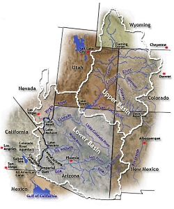
Colorado Compact Coverage, Courtesy AZwater.gov, https://www.azwater.gov/AzDWR/StatewidePlanning/CRM/images/map_main_large.jpg
Colorado Compact Coverage
https://www.azwater.gov/AzDWR/StatewidePlanning/CRM/images/map_main_large.jpg [Feb 27, 2014]
Courtesy AZwater.gov

The Colorado River Compact, Saving Water for Utah: Hoover Dam Courtesy USBR Hoover Dam
Courtesy USBR

Hi, this is Mark Larese-Casanova from the Utah Master Naturalist Program at Utah State University Extension.

The Colorado River Compact, written into law almost a century ago, helped ensure our survival in Utah today. We all know that Utah is a dry state. In fact, Utah is the second driest state in the country, with only Nevada being drier. Our average annual precipitation varies widely, from as low as a few inches a year near St. George, to as high as 60 inches in the mountains. Since most of our water comes from mountain snow, we rely on rivers and streams to deliver it to us.

The Colorado and Green Rivers, the largest in Utah, carry water from the Rocky, Wasatch, and Uinta Mountain ranges throughout Utah and the Intermountain West. The Colorado River Basin, the area of land from which the Colorado River and its tributaries drain water, covers the eastern half of Utah, along with the western half of Colorado, almost all of Arizona, and small parts of Wyoming, New Mexico, Nevada, and California. Each of these states has a dry climate, and water from the Colorado has always been in high demand.

In the heavily populated eastern United States, the right to use water often adheres to Riparian Doctrine in which water is shared by all those who live along the body of water. However, the western US was settled at different times, and populations are more sparse. So, water rights generally follow the doctrine of Prior Appropriation. That is, the water is set aside for whoever is able to use it first. The only problem is that California was developed earlier than the other states in the basin, and therefore, as the US Supreme Court ruled in 1922, was legally entitled to more than their fair share of the water! In this case, western water law simply didn’t work. So, all 7 states in the Colorado River Basin sat down together with the US Government and negotiated the Colorado River Compact to ensure that Utah and the other Upper Basin states were entitled to as much water each year as California and the other Lower Basin states that were growing at a faster rate.

So there you have it- one key piece of legislation helping to save civilization in Utah. Except, well, the amounts of water each state is entitled to was based on an abnormally high year of water flow… and, so, there often isn’t enough water to go around… and Mexico doesn’t seem to get much water at all. OK, so the Colorado River Compact isn’t perfect, but it’s important. To ensure that we all truly have enough water, it will take compromise, conservation, and a whole lot of common sense.

For Wild About Utah, I’m Mark Larese-Casanova.

Credits:

Images: Courtesy AZwater.gov
Text:     Mark Larese-Casanova

Additional Reading:

Gelt, J. Sharing Colorado River Water: History, Public Policy and the Colorado River Compact. Water Resources Research Center. https://wrrc.arizona.edu/publications/arroyo-newsletter/sharing-colorado-river-water-history-public-policy-and-colorado-river

US Bureau of Reclamation. The Colorado River Compact. https://www.usbr.gov/lc/region/pao/pdfiles/crcompct.pdf

US Bureau of Reclamation. The Law of the River. https://www.usbr.gov/lc/region/pao/lawofrvr.html

Law of the River, Colorado River Management, State of Arizona, https://new.azwater.gov/crm/law-river

Water Education Foundation. 1922-2007: 85 Years of the Colorado River Compact. https://www.watereducation.org/western-water-excerpt/1922-2007-85-years-colorado-river-compact

James, Ian, Scientists have long warned of a Colorado River crisis, The Los Angeles Times, July 15, 2022, https://www.latimes.com/california/story/2022-07-15/scientists-have-long-warned-of-a-colorado-river-crisis
A Grand Old River

A Grand Old River: The Island Acres Part of James M. Robb Colorado River State Park Fruita, CO Courtesy Daniel Smith, Photographer
The Island Acres Part of
James M. Robb Colorado River State Park
Fruita, CO
Courtesy Daniel Smith, Photographer

The Colorado River from Dead Horse Point State Park, near Moab,Utah, USA Courtesy Phil Armitage, Photographer The Colorado River from
Dead Horse Point State Park,
near Moab,Utah, USA
Courtesy Phil Armitage, Photographer

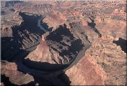
Confluence of the Colorado and Green Rivers in Canyonlands National Park Courtesy USGS Photo by Marli Miller, Photographer Confluence of the Colorado and Green Rivers
in Canyonlands National Park
Courtesy USGS
Photo by Marli Miller, Photographer

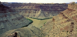
Confluence of the Colorado and Green Rivers in Canyonlands National Park Courtesy National Park Service Confluence of the Colorado and Green Rivers
in Canyonlands National Park
Courtesy National Park Service

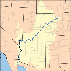
Map of the Colorado River Watershed by Karl Musser based on USGS data This file is licensed under the CCA ShareAlike 2.5 License. Map of the Colorado River Watershed
by Karl Musser based on USGS data
This file is licensed under the
CCA ShareAlike 2.5 License.

Hi, I’m Holly Strand of Stokes Nature Center in beautiful Logan Canyon.

The Colorado River is the largest waterway in the southwest. 1,450 miles long, the Colorado River basin drains 248,000 square miles in 7 large states. In Utah, the river enters near Cisco south of I-70, winds its way through Arches and Canyonlands National Parks, then flows through Glen Canyon and exits south into Arizona.

Less than 100 years ago, the Colorado River wasn’t in Utah or even in Colorado. Until 1920, “Colorado River” referred only to the river section downstream from Glen and Grand Canyons. Upstream, it was called the Grand River all the way up the headwaters in the Colorado Rockies. Thus we have Grand County in Utah and the town of Grand Junction in Colorado.

According to Jack Schmidt, professor in Utah State University’s Department of Watershed Sciences and a longtime scholar of the river, the good citizens of the state of Colorado weren’t pleased with the Colorado River’s location.
So in 1920, the Colorado Legislature renamed Colorado’s portion of the Grand River, with a somewhat awkward result: The Colorado River began in Colorado, became the Grand River at the border with Utah and then became the Colorado River again at the confluence with the Green.

This arrangement did not last long –again because of a Colorado legislator. U.S. Representative Edward T. Taylor, petitioned the Congressional Committee on Interstate and Foreign Commerce to rename the entire river as the Colorado. Despite objections from Utah and Wyoming representatives and the U.S. Geological Survey, the name change was made official by the U.S. Congress on July 25, 1921.

The objections were legitimate: In the 1890s the Federal Board on Geographic Names established the policy of naming rivers after their longest tributary. The former Grand River of Colorado and Utah was shorter than the Green River tributary by quite a bit. So the Green river should have prevailed and the Colorado should have been one of its tributaries.

However, if you judge tributary primacy by volume, the Colorado wins hands down. 100 years ago, the upper Colorado (or former Grand River) had a significantly higher total flow than the Green.

But what’s in a name? Prior to widespread European settlement, the Grand River was known as Rio Rafael and before that, different parts of the river had numerous Native American and Spanish names. A thousand years from now the rapidly evolving Colorado could have an entirely different identity. The main thing is that Utahns can enjoy and appreciate the habitat, scenery and many resources that this important waterway provides.

Thanks to the USU College of Natural Resources and the Rocky Mountain Power Foundation for supporting research and development of this Wild About Utah topic.

For Wild About Utah and Stokes Nature Center, I’m Holly Strand.

Credits:


Images:

JamesMRobbColorado_riverDanielSmith.jpg: Taken in the Island Acres Part of James M. Robb Colorado River State park by Daniel Smith and released into the Public domain.

DeadHorsePtSP_UtahPhilArmitage.jpg: The Colorado River from Dead Horse Point State Park, near Moab, Utah, USA. Photo by Phil Armitage (May be used for any purpose)

ConfluenceUSGSMarliMiller.jpg: Confluence of the Colorado and Green Rivers in Canyonlands National Park. USGS Photo by Marli Miller.

ConfluenceNPS.jpg: Confluence of the Colorado and Green Rivers in Canyonlands National Park. National Park Service.

Colorado River Watershed Map, by Karl Musser based on USGS data, licensed under the
Creative Commons Attribution ShareAlike 2.5 License: In short: you are free to share and make derivative works of the file under the conditions that you appropriately attribute it, and that you distribute it only under a license identical to this one. Official license


Text: Mary-Ann Muffoletto, Holly Strand, Content reviewed by Jack Schmidt of Utah State University’s Department of Watershed Sciences and a longtime scholar of the Colorado River.

Sources & Additional Reading:


Benke, A. C., and C. E. Cushing (editors). 2005. Rivers of North America. Academic/Elsevier. Amsterdam/Boston, 1168 pages.

Casey, Robert L. Journey to the High Southwest. Guilford, CT: Globe Pequot, 2007, p. 20.

Colorado Historical Society, Frontier Historical Society, www.bioguide.congress.gov

https://www.postindependent.com/article/20080325/VALLEYNEWS/68312863

”First Biennial Report of the Utah Conservation Commission, 1913,” Salt Lake City, Utah: The Arrow Press Tribune-Reporter Printing Co., 1913. p. 131.

McKinnon, Shaun. “River’s headwaters determined by politicians, not geography.” The Arizona Republic, 25 July 2004.

James, Ian, Scientists have long warned of a Colorado River crisis, The Los Angeles Times, July 15, 2022, https://www.latimes.com/california/story/2022-07-15/scientists-have-long-warned-of-a-colorado-river-crisis
A Grand Old River

A Grand Old River: The Island Acres Part of James M. Robb Colorado River State Park Fruita, CO, Courtesy Daniel Smith, Photographer
The Island Acres Part of
James M. Robb Colorado River State Park
Fruita, CO
Courtesy Daniel Smith, Photographer
Hi, I’m Holly Strand of Stokes Nature Center in beautiful Logan Canyon.A Grand Old River

The Colorado River is the largest waterway in the southwest. 1,450 miles long, the Colorado River basin drains 248,000 square miles in 7 large states. In Utah, the river enters near Cisco south of I-70, winds its way through Arches and Canyonlands National Parks, then flows through Glen Canyon and exits south into Arizona.

Less than 100 years ago, the Colorado River wasn’t in Utah or even in Colorado. Until 1920, “Colorado River” referred only to the river section downstream from Glen and Grand Canyons. Upstream, it was called the Grand River all the way up the headwaters in the Colorado Rockies. Thus we have Grand County in Utah and the town of Grand Junction in Colorado.

The Colorado River from
Dead Horse Point State Park,
near Moab,Utah, USA
Courtesy Phil Armitage, Photographer

According to Jack Schmidt, professor in Utah State University’s Department of Watershed Sciences and a longtime scholar of the river, the good citizens of the state of Colorado weren’t pleased with the Colorado River’s location.
So in 1920, the Colorado Legislature renamed Colorado’s portion of the Grand River, with a somewhat awkward result: The Colorado River began in Colorado, became the Grand River at the border with Utah and then became the Colorado River again at the confluence with the Green.

This arrangement did not last long –again because of a Colorado legislator. U.S. Representative Edward T. Taylor, petitioned the Congressional Committee on Interstate and Foreign Commerce to rename the entire river as the Colorado. Despite objections from Utah and Wyoming representatives and the U.S. Geological Survey, the name change was made official by the U.S. Congress on July 25, 1921.

Confluence of the Colorado and Green Rivers
in Canyonlands National Park
Courtesy USGS
Photo by Marli Miller, Photographer

The objections were legitimate: In the 1890s the Federal Board on Geographic Names established the policy of naming rivers after their longest tributary. The former Grand River of Colorado and Utah was shorter than the Green River tributary by quite a bit. So the Green river should have prevailed and the Colorado should have been one of its tributaries.

However, if you judge tributary primacy by volume, the Colorado wins hands down. 100 years ago, the upper Colorado (or former Grand River) had a significantly higher total flow than the Green.

Confluence of the Colorado and Green Rivers
in Canyonlands National Park
Courtesy National Park Service

But what’s in a name? Prior to widespread European settlement, the Grand River was known as Rio Rafael and before that, different parts of the river had numerous Native American and Spanish names. A thousand years from now the rapidly evolving Colorado could have an entirely different identity. The main thing is that Utahns can enjoy and appreciate the habitat, scenery and many resources that this important waterway provides.

Thanks to the USU College of Natural Resources and the Rocky Mountain Power Foundation for supporting research and development of this Wild About Utah topic.

For Wild About Utah and Stokes Nature Center, I’m Holly Strand.

Map of the Colorado River Watershed by Karl Musser based on USGS data This file is licensed under the CCA ShareAlike 2.5 License.
Map of the Colorado River Watershed
by Karl Musser based on USGS data
This file is licensed under the
CCA ShareAlike 2.5 License.

Credits:

Images:

JamesMRobbColorado_riverDanielSmith.jpg: Taken in the Island Acres Part of James M. Robb Colorado River State park by Daniel Smith and released into the Public domain.

DeadHorsePtSP_UtahPhilArmitage.jpg: The Colorado River from Dead Horse Point State Park, near Moab, Utah, USA. Photo by Phil Armitage (May be used for any purpose)

ConfluenceUSGSMarliMiller.jpg: Confluence of the Colorado and Green Rivers in Canyonlands National Park. USGS Photo by Marli Miller.

ConfluenceNPS.jpg: Confluence of the Colorado and Green Rivers in Canyonlands National Park. National Park Service.

Colorado River Watershed Map, by Karl Musser based on USGS data, licensed under the
Creative Commons Attribution ShareAlike 2.5 License: In short: you are free to share and make derivative works of the file under the conditions that you appropriately attribute it, and that you distribute it only under a license identical to this one. Official license


Text: Mary-Ann Muffoletto, Holly Strand, Content reviewed by Jack Schmidt of Utah State University’s Department of Watershed Sciences and a longtime scholar of the Colorado River.

Additional Reading

Many years ago, the Colorado River was just Grand, Summit Daily News, Frisco, CO, Dec 23, 2003, https://www.summitdaily.com/article/20031223/OPINION/312230302

Largest Rivers in the United States, J.C. Kammerer, USGS, Rev May 1990, https://pubs.usgs.gov/of/1987/ofr87-242/

Benke, A. C., and C. E. Cushing (editors). 2005. Rivers of North America. Academic/Elsevier. Amsterdam/Boston, 1168 pages.

Casey, Robert L. Journey to the High Southwest. Guilford, CT: Globe Pequot, 2007, p. 20.

Colorado Historical Society, Frontier Historical Society, www.bioguide.congress.gov

https://www.postindependent.com/article/20080325/VALLEYNEWS/68312863

”First Biennial Report of the Utah Conservation Commission, 1913,” Salt Lake City, Utah: The Arrow Press Tribune-Reporter Printing Co., 1913. p. 131.

McKinnon, Shaun. “River’s headwaters determined by politicians, not geography.” The Arizona Republic, 25 July 2004.

James, Ian, Scientists have long warned of a Colorado River crisis, The Los Angeles Times, July 15, 2022, https://www.latimes.com/california/story/2022-07-15/scientists-have-long-warned-of-a-colorado-river-crisis