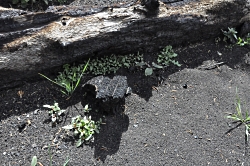
Bears

Bear jams, bear stories, bear encounters, bear dreams – I’ve experienced all. Such was the case on our annual Teton trip where I was joined by over 25 USU students and others. Bison, birds, bugling elk, sparring moose, and always the highlight- bears.

Nothing quite compares with the mighty bruins to captures one’s imagination- a combination of fear and reverence. They have been with us for many millennia, our companions of the wild. Perhaps it’s their almost human traits and mystery, their intelligence and unpredictability.
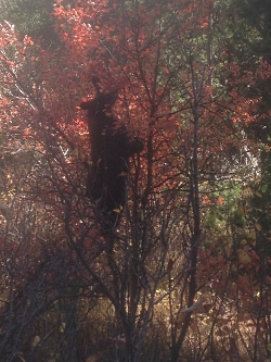
Black bear, Ursus americanus, eating hawthorn berries, Wilson Road, Teton N.P. 10/7/18 Courtesy and Copyright Jack Greene, Photographer
Black bear, Ursus americanus, eating hawthorn berries, Wilson Road, Teton N.P. 10/7/18
Courtesy and Copyright Jack Greene, Photographer
This year’s bears were especially close as their feeding frenzy took them on the roads edge where an abundance of hawthorn berries awaited their rapacious apatite. All of this topped by both black and grizzly, two juveniles oblivious to our presence as they went about preparing for their long winter sleep.

Berry feeding grizzly bear, Ursus arctos horribilis, a few hundred yards further down the road, Wilson Road, Teton N.P. 10/7/18, Courtesy and Copyright Jack Greene, Photographer
Berry feeding grizzly bear, Ursus arctos horribilis, a few hundred yards further down the road, Wilson Road, Teton N.P. 10/7/18,
Courtesy and Copyright Jack Greene, Photographer
Utah’s bears are in the same macrophage mode. Unfortunately, our grizzlies disappeared with “Old Ephraim”, a magnificent animal of unusual size and intelligence, well up in years before his life was taken by a legendary trapper, Frank Clark. Frank was so moved as the great bears spirit was released by his bullet, that he ended his long career after killing well over 100 in the Bear River Range of northern Utah.

Sixty-two people nationwide have been killed by black bears over a 109 period, only one of those in Utah. Avalanches, bee stings, and lightning kill far more people. But many Utah bears have been killed by hunters averaging around 130 per year. A few of these are killed by those who feel threatened. In rare instances, black bear will bluff charge, or clack their jaws, which is actually expressing fear of humans. Running away is their normal behavior.

Although a precise count isn’t available, Utah’s black bear population is somewhere between 3,000 and 3,500 animals. In 2008, 314 bear hunting permits were issued and 134 animals taken. Although a hunter, I have no desire to kill a bear. I consider them my spirit animal, having been near them most of my days- from early years in N. Wisconsin, working in Denali and Yellowstone N.P.’s, and spending many years in bear infested wild country otherwise. Forested areas of Central and S. Utah have much higher bear populations than does the north end. I’ve seen only bear sign in our mountains, still hoping to get a glimpse one day.

“Observing a bear dancing in the golden rays of the sun, a Shoshone sage understood it to be a dance of gratitude as well as a prayer for the healing and protection of their young. From that point further the Shoshone have instigated their own Sun Dance where the bear is a central figure of the ritual, symbolizing protection, strength and continuation of life.” Jack G.

This is Jack Greene- and I continue to be Wild About Utah!

Credits:

Images: Courtesy Jack Greene
Audio: Courtesy Western Soundscape Archive, University of Utah, licensed under CCA-ND
Courtesy National Park Service
Text:     Jack Greene

Sources & Additional Reading:

Venefica, Avia Native American Bear Meaning, Whats Your Sign, https://www.whats-your-sign.com/native-american-bear-meaning.html

Welker, Glenn, Native American Bear Stories, Indigenous People, last updated 06/11/2016, https://www.indigenouspeople.net/bear.htm

Gates, Chuck, The bear truth: Utah’s black bears pose little danger to humans, Deseret News, Oct 15, 2009, https://www.deseretnews.com/article/705336743/The-bear-truth-Utahs-black-bears-pose-little-danger-to-humans.html
A Desert’s Paradox

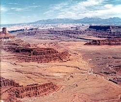
A Desert’s Paradox: Upheaval Dome Courtesy Wikimedia Licensed under the Creative Commons Attribution-Share Alike 3.0 Unported license.
Upheaval Dome
Courtesy Wikimedia
Licensed under the Creative Commons Attribution-Share Alike 3.0 Unported license.
A Desert’s Paradox
Have you ever wondered why the redrock landscape of Southeastern Utah ebbs and flows, why the exposed layers of sedimentary rock seem to rise and fall in crests and troughs like so many waves across the surface of the sea? Well, the answer, surprisingly enough, can be found through investigating the ancient seas that once covered vast swathes of Southeast Utah more than 300 million years ago.

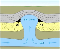
A Desert’s Paradox: Salt Diapir Courtesy Geology.com
Salt Diapir
Courtesy Geology.com
Back then, the allotment of Earth’s crust that would one day become the Beehive State was located along the western edge of a chain of islands that rose above a shallow, equatorial sea. 15 million years of sea level rise, recession, and evaporation left behind layer upon layer of salt deposits that would eventually measure nearly a mile thick. These salt deposits were subsequently covered and crushed by vast layers of sediment, rock, and debris eroded from the flanks of the Ancestral Rocky Mountains. Under the tremendous weight of these additional layers, the now lithified layers of salty stone softened and squirted west like toothpaste through a tube until they collided with deep tectonic faults. Here, they erupted upward, forcing the younger, denser rock layers into anticlinal arched domes, called diapirs, resembling the crests of waves. This phenomenon works much like a waterbed across the landscape: heavier rock layers squirting salt into thinner layers of rock that then bulge upward before they are subsequently squashed downward again by even more sediment, rock, and debris. The subterranean movement of salt through rock layers becomes a game of geologic whack-a-mole.

Cane Creek Anticline Canyonlands National Park Courtesy USGS, Public Domain, Photo id: 249988
Cane Creek Anticline
Canyonlands National Park
Courtesy USGS, Public Domain, Photo id: 249988
I recently visited Dead Horse Point State Park between the town of Moab and Canyonlands National Park. On the eastern edge of the rising mesa on which the park is located, one can look out across millions of years’ worth of sedimentary deposits toward the Cane Creek Anticline, an obvious salt diapir that seems to rise straight out of the Colorado River. Perhaps the most famous (and most contested) salt diapir in the area, though, is that of Upheaval Dome, located in Canyonlands National Park. An alternative theory to the creation of Upheaval Dome maintains that an ancient meteor impact created the crater where Upheaval Dome is located. However, the fracturing of the younger Wingate Sandstone that occupies the higher rock layers is indicative of a salt diapir formation. Yet, debate rages on!

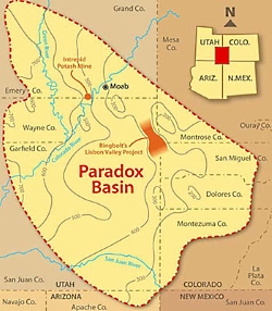
Paradox Basin Overview Courtesy & Copyright Buffalo Royalties
Paradox Basin Overview
Courtesy & Copyright Buffalo Royalties
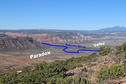
Funnily enough, the discovery of this layer of ancient salt deposits that wreaks so much havoc below the Earth’s surface was made in the collapsed center of an ancient salt diapir. In 1875, geologist and surveyor Albert Charles Peale, at the time yet unaware of the salt tectonics at work beneath the Colorado Plateau, noted the paradoxical course of the Delores River. As Peale and his colleagues would find out, the geography of the collapsed salt diapir caused the river to chart a perpendicular course through its valley as opposed to a parallel course as is most often taken by rivers. This paradox of fluvial geomorphology gave the place its name, Paradox Valley. Likewise, the subsequent discovery of an entire basin of ancient salt deposits borrowed the name “Paradox.” Now, we know the salty layer as the Paradox Formation of rocks found throughout the Paradox Basin of the Colorado Plateau.

Paradox Valley Courtesy & Copyright GJhikes.com
Paradox Valley
Courtesy & Copyright GJhikes.com
This paradox of fluvial geomorphology can also be found where the Colorado River cuts a perpendicular course across the Spanish Valley of Moab and is indicative of a vast layer of ancient salts below the surface, waiting to further morph the landscape into crests and troughs of rocky waves that ebb and flow across the landscape. The next time you venture into this part of our great state, stop and consider the remnants of ancient seas below your feet that project their image into the surface of the redrock above.

I’m Josh Boling, and I’m Wild About Utah.

A Desert’s Paradox-Credits:

Photos: Paradox Basin Overview, Courtesy and Copyright Buffalo Royalties
Upheaval Dome Courtesy Wikimedia, https://commons.wikimedia.org/wiki/File:UpheavalDomePanorama.jpg
Salt Diapir Courtesy Geology.com, https://geology.com/stories/13/salt-domes/
Paradox Valley Courtesy GJhikes.com, https://www.gjhikes.com/2017/10/long-park.html
Cane Creek Anticline Courtesy USGS (Photo id: 249988 – Canyonlands National Park, Utah. Cane Creek anticline, looking northeast toward the La Sal Mountains from Dead Horse Point. The Colorado River cuts across the crest at the middle right, above which is Anticline Overlook. A jeep trail and part of Shafer dome lie below. Figure 13, U.S. Geological Survey Bulletin 1327. – ID. Lohman, S.W. 10cp – lswc0010 – U.S. Geological Survey – Public domain image)
Text: Josh Boling, 2018

A Desert’s Paradox-Additional Reading

Davis, Jim, Glad You Asked: Why Does A River Run Through It?, Glad You Asked, Utah Geological Survey, https://geology.utah.gov/map-pub/survey-notes/glad-you-asked/why-does-a-river-run-through-it/

Hylland, Rebecca, What are Igneous, Sedimentary & Metamorphic Rocks?, Glad You Asked, Utah Geological Survey, https://geology.utah.gov/map-pub/survey-notes/glad-you-asked/igneous-sedimentary-metamorphic-rocks/

Wildfires

Wildfires: Smoke roils from 2012 wildfire in Utah. Photo by U.S. Forest Service.
Smoke roils from 2012 wildfire in Utah. Photo by U.S. Forest Service.

Wildfires hit record highs this year in the Western U.S. There can be arguments blaming Climate Change or Forest Management. Were they caused by human carelessness or natural causes such as lightning? Take your pick. But the results were tragic.

Through August this year, Utah has had nearly 1,300 fires which burned nearly a quarter million acres and cost $100 million dollars.

Nationally, 90% of wildfires are human-caused from unattended campfires, discarded cigarettes, mismanaged debris fires and planned acts of arson. And the cost of those fires exceeded $5 billion dollars over the last 10 years. From January to August in 2018 there were nearly 39,000 different fires that burned over 5 million acres.

Much has been said about those tragic statistics that affect the loss of human life, the destruction of developed properties, the discomforts of evacuations, and the enormous costs and dangers of fighting fires as the horrible results of these runaway infernos. But, what about next year? Will the drought continue? Will the climate continue to set record temperatures?

Burned Stumps & Ashes Courtesy & Copyright Friend Weller, Photographer
Burned Stumps & Ashes
Courtesy & Copyright Friend Weller, Photographer

One of the consequences that has not been discussed much is the loss of millions of trees. What can we expect when living trees are turned into burned stumps and ashes?

The major greenhouse gas in our atmosphere is Carbon Dioxide. It is called a green house gas because it warms the earth’s temperature. Carbon dioxide is produced by the burning of fossil fuels or trees, chemical reactions such as the manufacture of cement, and the exhaling of animals. It is removed from the atmosphere when it is absorbed by land-plants and the ocean as part of the biological carbon cycle. The role the ocean plays in the carbon cycle is a topic for another program.

It is the loss of trees that we will consider now.
I will mention only a few of the many benefits trees provide.

You may recall from biology class that the trees take-in carbon dioxide and release oxygen. Forest fires require oxygen to burn, and we require oxygen to live. This year, we have already lost 5 million acres of oxygen production.

There are trees, such as the Lodgepole Pine, which have serotinous cones which release their seeds during the intense heat of forest fires. But it will take 40 years for those seeds to
grow into mature trees.

Another consideration is the loss of trees along hillsides and mountain slopes. When rain or snow hits those barren areas there can be massive soil erosion. This not only pollutes the streams and rivers below, but eliminates the top layer of soil where new seeds would best survive.

Besides the loss of human homes, there is the loss of wildlife habitat to consider. IF animals were able to escape massive fires, they must then find suitable habitat, which may encroach on human developments.

Then there is the loss of shade. Barren land will be more susceptible to collecting heat from the sun’s rays, which then will cause more heating of the atmosphere.

So, what can we do about this? First, be extremely careful with fire; Second, plant trees in your communities; Third, contact your local Ranger District or U.S. Forest Service to see if you can volunteer in tree planting projects.

This is Ron Hellstern, and I am Wild About Utah.
 
Credits:

Images: Courtesy USDA Forest Service,
https://www.srs.fs.usda.gov/compass/2013/05/28/climate-change-and-wildfire/
Audio: Contains audio courtesy
Freesound.org, Sound provided by Dynamicell
https://freesound.org/people/Dynamicell/sounds/17548/
Text: Ron Hellstern, Cache Valley Wildlife Association

Job & Volunteering

USDA Forest Service Offices:
Region 4: Intermountain Region
Federal Building
324 25th Street
Ogden, UT 84401
801-625-5605
[Job & Volunteering] Connections, https://www.fs.usda.gov/main/r4/jobs
Volunteer Opportunities, https://www.fs.usda.gov/main/r4/jobs/volunteer

Volunteer, TreeUtah, https://treeutah.org/volunteer/

Outka-Perkins, Lisa, Welcome to the Forest Service: A Guide for Volunteers, USDA Forest Service, Feb 2009,
https://www.fs.fed.us/t-d/pubs/pdfpubs/pdf09672813/pdf09672813dpi72.pdf

Additional Reading

Boling, Josh, Fire, Wild About Utah, August 13, 2018, https://wildaboututah.org/fire/

Strand, Holly, Investigating the Causes of Wildfires, Wild About Utah, Aug 15, 2013, https://wildaboututah.org/investigating-the-causes-of-wildfires/

Larese-Casanova, Mark, Wildfires in Utah, Wild About Utah, July 26, 2012, https://wildaboututah.org/wildfires-in-utah/

Preparing Home and Property for Wildlife, A Proactive Approach, Utah Living With Fire, Salt Lake City, UT, https://www.utahlivingwithfire.com/

Live Worldwide Network for Lightning and Thunderstorms in Real Time, Blitzortung, https://en.blitzortung.org/live_lightning_maps.php?map=30

Aspen Seedlings on the Brian Head Fire Footprint

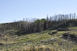
Aspen Seedlings on the Brian Head Fire Footprint: A few remaining aspen trees standing after the Brian Head fire Courtesy & Copyright Karen Mock, Photographer
A few remaining aspen trees standing after the Brian Head fire
Courtesy & Copyright Karen Mock, Photographer

The rustling noise of wind blowing through aspen trees is a sweet sound for many Utahns, reminding them of home.Aspen Seedlings on the Brian Head Fire Footprint

The quaking aspen became Utah’s state tree in 2014.   It grows in all 29 counties and is recognized by its off-white bark with black spots and streaks. In the fall, aspen’s heart-shaped leaves turn bright yellow and make a vibrant splash of color against backdrops of green conifers and rocky ridges.

In addition to its aesthetic value, aspen helps to create habitat for wildlife, provide shelter for livestock, and increase bird and plant diversity. In a fire, aspen burns less readily than other trees, so aspen forests can help reduce fire risk.

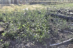
Aspen suckers growing between fallen wood from the Brian Head fire Courtesy & Copyright Karen Mock, Photographer
Aspen suckers growing between fallen wood from the Brian Head fire
Courtesy & Copyright Karen Mock, Photographer

The aspens reproduce in two different ways.  The most common way is they make root sprouts called “suckers”, which are genetically identical to the root, and can lead to the formation of a group of identical trees called a “clone”. 

The second less common way is when aspen produce seeds, the seedlings have a mixture of genes from two parent trees.   Aspen do not produce seeds every year, and seedlings can have a hard time getting established in dry soils.

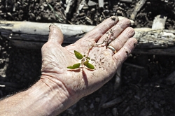
Aspen seedling from the Brian Head fire footprint. Courtesy & Copyright Karen Mock, Photographer Courtesy & Copyright Karen Mock, Photographer

Rumor has it an early USU Forestry professor offered an A to any student who could find an aspen seedling in the wild, making the point of how rare the seedlings were.   However, research at USU and elsewhere over the past decade is showing that aspen seedlings may be more common than we think, especially after fires. 

In the summer of 2017, the Brian Head fire burned over 70,000 acres in the high country of southern Utah.  Aspen is already playing a large role in the regeneration of this forest, producing a thicket of suckers under preexisting aspen

In July of this year, homeowners Mike and Julie Saemisch “Samish” in Brian Head, Utah were walking through some surviving aspens in the fire footprint,  when they noticed something unusual and surprising – these aspens were producing an extraordinary amount of seeds.

They brought this to the attention of USU Professors Larissa Yocom, a fire ecologist, and Karen Mock, an aspen geneticist, both in the Department of Wildland Resources, in the Quinney College of Natural Resources. 

Yocom said, “It looked like snow in July, there was so much aspen cotton draped over every surface.”

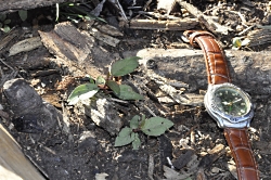
Mock visited the site in September to see whether these seeds were germinating.  She explains, “Seedlings were everywhere – thousands and thousands of them, including in places where aspen did not previously exist”. 

Aspen seedling growing on the Brian Head fire footprint. Courtesy & Copyright Karen Mock, Photographer Courtesy & Copyright Karen Mock, Photographer
Aspen seedling growing on the Brian Head fire footprint.
Courtesy & Copyright Karen Mock, Photographer

According to Yocom, “Fire has created a window of opportunity [for aspen] by opening up growing space [and decreasing competition]. It removed trees, shrubs, and understory plants that compete with small aspen.  The [seedlings] have nutrients, water, sunlight, and open soil free from fallen leaves and vegetation.”

Aspen seedling growing near charred tree from the Brian Head fire Courtesy & Copyright Karen Mock, Photographer
Aspen seedling growing near charred tree from the Brian Head fire
Courtesy & Copyright Karen Mock, Photographer

Mock explains, “All the right ingredients came together for this to happen: fire, seed production, and good monsoon rain timing.  Events like this can present an opportunity for adaptive evolution, range expansion and range shifts in aspen, and those events can leave a mark for hundreds or thousands of years”.

Yocom adds, “A post-fire environment can be harsh with high temperatures at the soil surface and little shade.  But if the seedlings survive through their most vulnerable stage they can grow quickly and may establish dominance across a huge area in the Brian Head Fire footprint.”

Yocom and Mock hope to study the survival of these aspen over the coming years, to find out which aspens survive and how big of an impact herbivory has on the suckers and seedlings.  They hope that this research will help guide future post-fire management practices to encourage strong aspen regeneration after fires.

This is Shauna Leavitt and I’m Wild About Utah.

Aspen Seedlings on the Brian Head Fire Footprint-Credits:
Photos: Courtesy & Copyright © Karen Mock, Wildland Resources, Quinney College of Natural Resources, Utah State University, https://qcnr.usu.edu/directory/mock_karen
Audio: Courtesy Western Soundscape Archive, University of Utah, Sound provided by Jeff Rice, licensed under CCA-ND
Text: Shauna Leavitt, Utah Cooperative Fish and Wildlife Research Unit, Quinney College of Natural Resources, Utah State University

Aspen Seedlings on the Brian Head Fire Footprint-Additional Reading

Brian Head Fire Rehabilitation Project, USDA Forest Service, https://www.fs.usda.gov/project/?project=52918

Wildland Fire, Managing Land, USDA Forest Service, https://www.fs.fed.us/managing-land/fire

Donations, Working With Us, USDA Forest Service, https://www.fs.fed.us/working-with-us/donations

After the Fire, Pioneer Fire Reforestation on the Boise National Forest, USDA Forest Service, https://www.fs.fed.us/science-technology/fire/after-fire

Maffly, Brian, A year after southern Utah’s Brian Head Fire, the aspens are bouncing back in a surprising way that could strengthen the forest, The Salt Lake Tribune, Oct 22, 2018, https://www.sltrib.com/news/environment/2018/10/22/year-after-southern/