-Wetlands-What’s in a name?
-Wetlands-What’s in a name?

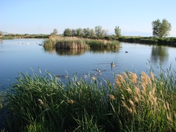
-Wetlands-What's in a name? Click to view larger view of a Pond and marsh showing wetland plants with Canada geese goslings and pelicans. Photo Courtesy and Copyright Mark Larese-Casanova
Pond and marsh showing
wetland plants with
Canada geese goslings and pelicans.
Courtesy & Copyright ©
Mark Larese-Casanova
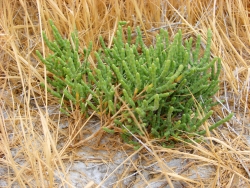
-Wetlands-What's in a name? Click to view larger view of Pickleweed growing in a salt playa is adapted to growing in saline soils. Photo Courtesy and Copyright Mark Larese-Casanova
Pickleweed growing in a salt playa
is adapted to growing in saline soils.
Courtesy & Copyright ©
Mark Larese-Casanova
Hi, this is Mark Larese-Casanova from the Utah Master Naturalist Program at Utah State University Extension.-Wetlands-What’s in a name?

A wetland really is more than just ‘land that is wet’. There are certain key ingredients that need to go into a wetland for it to truly be a wetland. Of course, water needs to be present for at least part of the growing season. It can simply be in the form of temporarily saturated soils or even standing water a few feet deep.

As soil becomes saturated with water, oxygen levels are greatly reduced. Quite often, bacteria in saturated soils will create hydrogen sulfide, giving wetland soils that stinky odor of rotten eggs. As plants grow in a wetland over several years, their decaying matter helps to create a thick, dark layer of organic soil.

The presence of water in a wetland encourages the growth of hydrophytes, or ‘water-loving’ plants, that are specially adapted to living in wet environments. Many wetland plants have open spaces within the leaves and stems- often referred to as aerenchyma. This allows oxygen to diffuse down to the roots, sometimes creating an oxygen-rich environment in the soil around a plant. Also, many wetland plants reproduce both by floating or wind-dispersed seeds and by rhizomes, which are underground roots that can travel great distances. Some plants that grow in salty wetlands around Great Salt Lake are able to control the salt in their tissues by depositing it on the outside of the leaf or containing it in chambers within their cells.

Like plants, specially adapted animals also call wetlands their home. Mammals and birds have oily fur or feathers that allow them to swim in cold water without losing much body heat. They also often have webbed feet to aid in swimming. Other animals, such as fish, amphibians, and insects, have gills to breathe in water.

Despite being the second driest state in the country, Utah has a high diversity of wetlands. Vast marshes surround the Great Salt Lake, providing habitat to enormous populations of migratory birds. Less obvious wet meadows provide unique habitat to butterflies and other insects. Salty playas which are shallow basins with no outlet, are found throughout the West Desert, creating unique ecosystems of highly adapted plants. Riparian wetlands can grow along the edges of rivers, providing a unique transition between the swift water and upland habitats. Southern Utah is home to some peculiar wetlands such as potholes and hanging gardens, both associated with sandstone bedrock. A hanging garden clings to the side of a moist cliff, creating a microhabitat for rare plants, such as orchids and monkeyflower. Potholes can simply be eroded basins in the sandstone where water collects in spring. A pothole is an oasis that provides water for desert wildlife and a home for fairy shrimp and spadefoot toads.

Spring is the perfect time of year to visit a wetland. The constant chorus of birds, insects, and amphibians are a testament to the importance of wetlands, teeming with life in the middle of a desert.

For Wild About Utah, I’m Mark Larese-Casanova.

Credits:

Images: Courtesy & Copyright © Mark Larese-Casanova

Text:     Mark Larese-Casanova, Utah Master Naturalist Program at Utah State University Extension.
Additional Reading:

Mitsch, W.J., and J.W. Gosselink. (1993). Wetlands. Van Nostrand Rheinhold.

Tiner, R. W. (1999). Wetland Indicators: A Guide to Wetland Identification, Delineation, Classification, and Mapping. CRC Press

Utah Division of Wildlife Resources. (1995). Playas to Marshes…Where Water Meets Land. Growing WILD Newsletter. https://www.wildlife.utah.gov/education/newsletters/95spring-gw.pdf

Utah Division of Wildlife Resources. (2003). Utah’s Wonderful Wetlands Activity Guide. https://wildlife.utah.gov/education/pdf/wetlands_activity_guide.pdf

-Wetlands-What’s in a name?
The Raft River Mountains

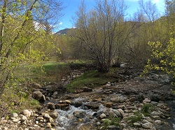
The Raft River Mountains: Clear Creek in Spring
Clear Creek in Spring
Courtesy & Copyright Holly Strand

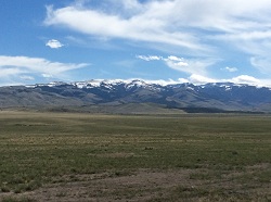
The Raft River Mountains: Raft River MountainsRaft River Mountains
Courtesy & Copyright Holly Strand

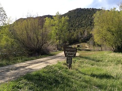
The Raft River Mountains: Near Clear Creek Campground.Near Clear Creek Campground.
Courtesy & Copyright Holly Strand


Hi, I’m Holly Strand of the Quinney College of Natural Resources at Utah State University.

In each of Utah’s six corners you’ll find one or more remarkable natural features. Moreover, each corner represents a totally different geographic environment. No doubt you are familiar with turquoise blue Bear Lake in the upper northeast and the magnificent High Uintas near the angle formed by Wyoming. Flaming Gorge and Dinosaur National Monument flank the lower northeast corner. The ancient ruins and Monument Valley draw international visitors to the southeast corner. The numerous canyon parks in Utah’s southwest corner offer endless opportunities for exploration. 

That’s five corners. But what do you know about the northwest corner of our state? I live in Northern Utah and I had never been there. Resolved to correct this omission I consulted a map as well as Joan Hammer of Box Elder County’s Office of Tourism. I concluded that the Raft River Mountains were worth checking out. The highest point in the County, Bull Mountain is here. And the 40 mile long range defines the southernmost section of Sawtooth National Forest.

The Raft River Mountains are unusual in that they run east-west. The normal pattern for Basin and Range country is north-south. The east-west orientation creates an important geographic dividing line. For Clear Creek drains the northern slopes of the Raft River Mountains. Then Clear Creek joins the Raft River which flows north to the Snake River. Thus the mountains form the sole—and very small—piece of Utah real estate that belongs to the great Colombia River Basin. The southern slopes are part of Great Basin. Rain or snow falling on this side is absorbed into the ground or evaporates.

Another interesting fact: The Raft River Mountains is where you can view some of the oldest rock in Utah. In this region, outcrops of Precambrian material are 2.5 billion years old. The largest and thickest exposures are in the eastern half of the range.

The Raft River Mountain peaks may not make it onto post cards. But when I saw them they were nothing less than beautiful. The lower slopes of sagebrush had the grayish-green tint that emerges all too briefly in the spring. Snow still gleamed on the 8-9000 foot summits. Clear Creek was running full through riparian forest that was just starting to leaf out. There were no people at the campground but wildlife was plentiful. I saw wild turkey, deer, jackrabbits and squirrels. A few pronghorn looked up as I drove out through the sagebrush. All in all, I found Utah’s sixth corner to be well worth a visit.

For pictures and more information about the Raft River Mountains, go to www.wildaboututah.org

For Wild About Utah, and the Quinney College of Natural Resources, I’m Holly Strand.

Credits:

Images: Courtesy and Copyright Holly Strand
Text: Holly Strand

Additional Reading

Doelling, Hellmut H. Geology and Mineral Resources of Box Elder County. Utah Geological and Mineral Survey. 1980. Bulletin 115.,

Stokes, William Lee. 1988. Geology of Utah. Salt Lake City: Utah Museum of Natural History. SummitPost.org Bull Mountain. https://www.summitpost.org/bull-mtn-ut/183282https://www.summitpost.org/bull-mtn-ut/183282 [Accessed May 13, 2014 and July 10, 2020]

USDA Forest Service. Sawtooth National Forest, Raft River Division. https://www.fs.usda.gov/recarea/sawtooth/recarea/?recid=5806 [Accessed May 13, 2014 and July 10, 2020]

Hylland, Rebecca, What are Igneous, Sedimentary & Metamorphic Rocks?, Glad You Asked, Utah Geological Survey, https://geology.utah.gov/map-pub/survey-notes/glad-you-asked/igneous-sedimentary-metamorphic-rocks/

Trouble with Tumbleweeds

Tumbleweed in Marsh, Courtesy and Copyright Anna Bengston
Tumbleweed in Marsh
Courtesy & Copyright Anna Bengston

Immortalized on the sets of old western movies, the tumbleweed has long been a classic symbol of the rugged, wide-open landscapes of the American West.  As a result, we can all easily recognize the spherical skeletons when we come across them caught on underbrush or piled up on fence lines here in Utah.  But this archetype is not an accurate representation of typical western United States or Utah flora, because tumbleweed– or Russian thistle –is an invasive weed.

The story begins in the late 19th century, when South Dakotan farmers reported seeing an unknown plant growing in their croplands.  Years later, it was identified as Russian thistle, scientific name Salsola tragus, a native plant of Russia and the Eurasian steppes east of the Ural Mountains.  It had been accidentally brought to the United States in a shipment of flaxseed.  By the time the U.S. Department of Agriculture published its inquiry into the plant in 1894, about 20 years after the plant’s introduction, 35,000 square miles of land had become “more or less covered” in Russian thistle.  Since that time the plant has spread into every state except Florida and Alaska.

So what is the problem?  Russian thistle, despite the nostalgic connotations of the old west it inspires, is a pest.  It easily takes root in disturbed or bare ground, moving in before native species are able to establish.  Drought conditions like those we have had in recent years only promote the plant’s proliferation.  The dryness hinders the growth of crops and native species, while the Salsola seed requires very little moisture in order to germinate and grows in where the crops and native species otherwise would have.  This can have deleterious effects on cropland and natural ecological functioning. Not to mention the wildfire risk the dry plant debris poses.

Salsola’s sheer numbers have also turned into more than just a nuisance.  Each plant may bear some 250,000 seeds that can be spread across miles as they drop off the rolling tumbleweed.  Consequently, we see images like those from Colorado earlier this year depicting piles of tumbleweeds filling streets, covering cars, and climbing the walls of houses.  In one instance, a windstorm clogged a town in New Mexico with 435 tons of the weed.

Utahns have yet to experience the full effects of this plant’s troublesome nature, but this does not mean we are immune; Russian thistle has been reported in every county of the state.  Luckily, for those fighting this plant’s advance, technology and research are on our side.  Several biological control options– from insects to fungal pathogens –are being tested as methods of natural Salsola population suppression with encouraging results.  But, all in all the management principles have not changed much since 1894: prevent the production and dispersal of seed across all infested areas.

For Wild About Utah, I’m Anna Bengtson.

Credits:
Image: Courtesy and Copyright Anna Bengston
Text: Anna Bengston

Sources & Additional Reading:

Banda, S. (2014, April 9). Tumbleweed troubles: Colorado drought creates perfect storm for road-clogging weeds. . US News. Retrieved May 2, 2014, from https://www.usnews.com/news/us/articles/2014/04/09/colorado-tumbleweeds-overrun-drought-areas

Coffman, K. (2014, March 27). Tumbleweeds plague drought-stricken American West.Reuters. Retrieved May 2, 2014, from https://www.reuters.com/article/2014/03/27/us-usa-tumbleweeds-idUSBREA2Q14E20140327

Dewey, L. (1894). The Russian thistle : its history as a weed in the United States, with an account of the means available for its eradication. U.S. Department of Agriculture, Division of Botany, Washington: Government Printing Office. Retrieved May 2, 2014, from https://archive.org/stream/russianthistleit15dewe#page/n5/mode/2up

EDDMapS. 2014. Early Detection & Distribution Mapping System. The University of Georgia – Center for Invasive Species and Ecosystem Health. Available online at https://www.eddmaps.org/; last accessed May 1, 2014.

Gilman, S. (2014, February 11). Troubleweeds: Russian thistle buries roads and homes in southeastern Colorado. . — High Country News. Retrieved May 2, 2014, from https://www.hcn.org/blogs/goat/troubleweeds-russian-thistle-buries-roads-and-homes-in-southeastern-colorado

Gilman, S. (2014, March 17). A plague of tumbleweeds: A handy pamphlet on how to dig out from a tumbleweed takeover of sci-fi proportions. . — High Country News. Retrieved May 2, 2014, from https://www.hcn.org/issues/46.5/a-plague-of-tumbleweeds

Main, D. (2011, March 2). Consider the tumbleweed. » Scienceline. Retrieved May 2, 2014, from https://scienceline.org/2011/03/virtues-of-a-weed/

Mazza, E. (2014, April 9). Tumbleweeds Reclaim West Amid Drought, Blocking Roads And Canals. The Huffington Post. Retrieved May 2, 2014, from https://www.huffingtonpost.com/2014/04/09/tumbleweeds_n_5115734.html

Ostlind, E. (2011, March 9). Tumbling along. — High Country News. Retrieved May 2, 2014, from https://www.hcn.org/blogs/goat/tumbling-along

Ostlind, E. (2001, May 20). It may be High Noon for tumbleweed. — High Country News. Retrieved May 2, 2014, from https://www.hcn.org/wotr/it-may-be-high-noon-for-tumbleweed

Russian Thistle (Salsola tragus). (n.d.). Russian Thistle (Salsola tragus). Retrieved May 2, 2014, from https://www.blm.gov/ca/st/en/fo/hollister/noxious_weeds/nox_weeds_list/russianthistle.html

USDA, NRCS. 2014. The PLANTS Database (https://plants.usda.gov, 8 May 2014). National Plant Data Team, Greensboro, NC 27401-4901 USA.

Medusahead Rye

Medusahead Rye Infestation
Courtesy and
Copyright © Steve Dewey

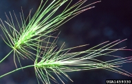
Flower
Courtesy and
Copyright © Steve Dewey

Plant
Courtesy and
Copyright © Steve Dewey

Weedy plants of old world origin threaten natural areas throughout the United States. An invading plant colonizing a completely new area often lacks the insects, diseases and herbivores that kept it in check back in its native homeland. If the introduced plant grows and spreads vigorously, it can spell disaster for the native inhabitants of its new home. With no natural controls in place, it may outcompete native plants and greatly diminish biodiversity. Disturbed or degraded habitats are most susceptible to invasion by Eurasian weeds.

Utah hosts many invasive weeds causing problems throughout the state. One Eurasian grass threatening sagebrush habitat and rangeland is medusahead rye. Medusahead rye probably came to the United States as a seed contaminant in the 1880’s. The seed head is heavy, so on its own, cannot spread far. But the seeds do have a ticket for dispersal: tufted hairs which cling and readily attach to livestock and vehicles. Once on site, medusahead grows vigorously, crowding out other plants.

Medusahead tissue contains abundant silica which slows its decomposition. The accumulation of dead material forms a dense thatch that smothers other plants. This dry thatch layer can also fuel wildfires. In addition, the gritty silica makes medusahead unpalatable, so both domestic and wild grazing animals avoid eating it. Infested ranches can lose 3/4 of their grazing capacity.

Sage grouse are already in trouble due to habitat loss, and medusahead has invaded more than 10 million acres of the sage brush that sage grouse call home. Once invaded by medusahead, sagebrush habitat is very difficult to restore. The best hope is to prevent or at least hinder its spread through management using controlled burns, herbicides and careful grazing. Non-native, invasive plants are among the most serious threats to our natural world and the habitats and species we know and love.

This is Linda Kervin for Bridgerland Audubon Society.

Credits:

Images: Courtesy Steve Dewey & www.invasive.org
Center for Invasive Species and Ecosystem Health, University of Georgia
Theme: Courtesy & Copyright Don Anderson as performed by Leaping Lulu
Text & Voice: Linda Kervin, Bridgerland Audubon Society

Additional Reading:

Linda Kervin’s pieces on Wild About Utah

The United States National Arboretum. formerly https://www.usna.usda.gov/Gardens/invasives.html

National Invasive Species Information Center. https://www.invasivespeciesinfo.gov/plants/medusahead.shtml

Forest Service Employees for Environmental Ethics. https://www.fseee.org/component/content/article/1002329

Utah State University Cooperative Extension. https://extension.usu.edu/cache/files/uploads/Medusahead%202-10.pdf