The Logan Island Twin Rivers Reverence Vibe

The first reach of the Little Logan River at River Hollow Park. This is the river’s connection to the Logan River, and in the proposed Logan River Watershed Plan it will be an excavated to bury piped water, severing the historic Little Logan River from the Logan River forever. Courtesy &amp Copyright Hilary Shughart, Photographer
The first reach of the Little Logan River at River Hollow Park. This is the river’s connection to the Logan River, and in the proposed Logan River Watershed Plan it will be an excavated to bury piped water, severing the historic Little Logan River from the Logan River forever.
Courtesy &amp Copyright Hilary Shughart, Photographer
The City of Logan has a special Logan Island Vibe anchored in the two arms of the Logan River which wrap around the heart of town as living blue trails and green stripes. We are the rivers, wetlands, and riparian buffers keepers.

This USGS map shows both the Logan River and the upper Little Logan River. These rivers define the Island district where Logan was originally founded. Click for a larger view and zoom in to Logan, UT
This USGS map shows both the Logan River and the upper Little Logan River. These rivers define the Island district where Logan was originally founded.
 
Click for a larger view in a new tab or window and search for or zoom-in to Logan UT, https://apps.nationalmap.gov/viewer/
Our stewardship is dictated by the laws we enact, and those laws include science-based riparian buffers based on best management practices. Let’s preserve and rehabilitate our natural resource treasures, not least of which the Logan River system, which includes the Logan River flowing out of Logan Canyon, and then forking into the North and South Branches which embrace the Logan Island.

Let’s celebrate our Logan Island Twin Rivers Reverence Vibe with poetry and conservation actions, such as planting native plant riparian buffers and ensuring this Tree City USA maintains a healthy tree canopy, clean water, and a thriving Natural Stream Environment, filled with the delights of birds and bird song, which are actual metrics of the health of a city.

The Logan Island Twin Rivers Reverence Vibe

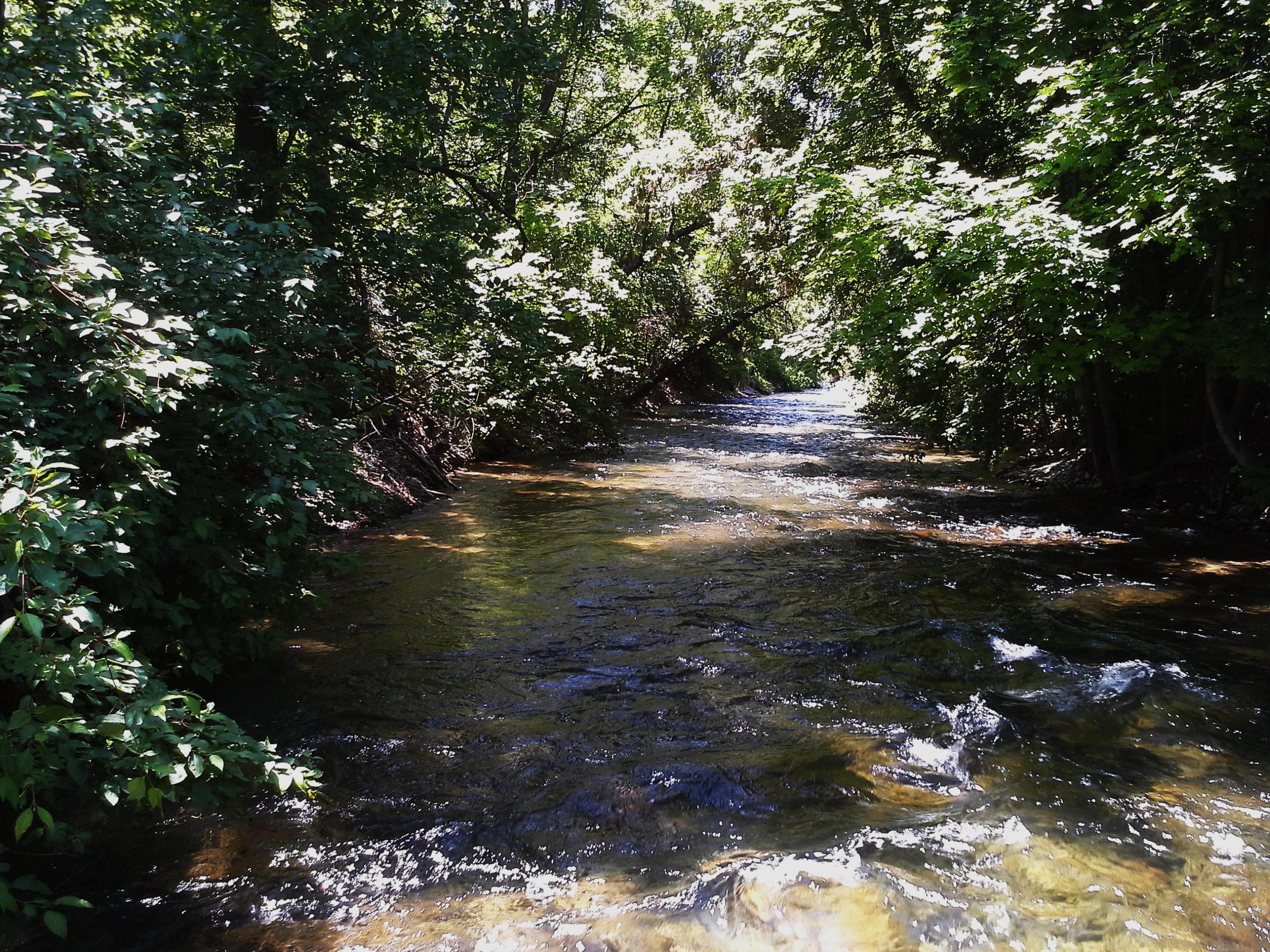
The Logan River meanders gracefully from the mouth Logan Canyon,
Generating electricity here, filling First Dam Reservoir there,
Flowing through the World Class Utah State University Water Research Laboratory,
With a mile and a half southwesterly meander past Herm’s Inn here, and River Hollow Park there,
Forking to wrap around the Logan Island, twin blue trails
weaving green stripes of riverside parks,
Sustaining our urban ecosystem,
This one wild and beautiful Logan Island
Twin Rivers Reverence Vibe,
Natural Community,
Lifeline.

I’m Hilary Shughart with the Bridgerland Audubon Society, and I am Wild About the North and South Branches of the Logan River, and I am Wild About Utah!

Credits:
Images: Little Logan River Courtesy & Copyright Hilary Shughart, Photographer
Featured Audio: Courtesy Friend Weller, Chief Engineer Retired, UPR.org, Courtesy & Copyright © Kevin Colver, https://wildstore.wildsanctuary.com/collections/special-collections/kevin-colver
Text: Hilary Shughart, President, https://bridgerlandaudubon.org/
Additional Reading: Hilary Shughart and Lyle Bingham, https://bridgerlandaudubon.org/

Additional Reading

Other Wild About Utah pieces authored by Hilary Shughart

Save and Restore the North Branch of the Logan River (Little Logan River), Bridgerland Audubon Society, https://bridgerlandaudubon.org/llr/

Guide to The Logan River Trail
iFIT parking lot to Trapper Park
Read to Logan City Council April 1, 2025
by Logan Poet Shanan Balkan
,

First, we pass under the traffic bridge
where barn swallows build nests of mud.
They disappear in late autumn
leaving stains where their nests once clung
to the underpass.
The river blurs turquoise to brown
under the bridge.

Bright green watercress thrives
year-round in the little stream—
see how it grows thicker by the day.
Notice the informational signs about what kinds of birds
live near the river:
red-winged blackbirds with a patch of ruby on their wings,
emerald-headed mallards, and raucous kingfishers—
now we pass a sign of fish who live in the river—
iridescent rainbow and Bonneville Cutthroat trout who wave
their tails in the swift green current.

See the majestic Wellsville mountains
jut sharp into the western sky.
They shine white, snow-covered,
late into summer.
Did you know that they are the steepest mountains
in the lower 48 states?

Turn around and see the Bear River Mountains
rise emerald behind us in the east.

Now we pass the pastures that fence horses—
dozens of them, black, white, chestnut.
A few hang their velvet snouts
over the fence to greet passersby.
The pastures shine with puddles,
bright pale hay.
The pastures smell of rich thaw,
horse manure.

Hear the music of frogs croaking,
and see the black-necked garter snakes
coiled, shy and olive-bodied,
on the edges of the trail in the grass.

The air vibrates with the jubilant
conk-conk-la-ree!
of red-winged blackbirds
and the cheerful chick-a-dee-dee-dee of black capped chickadees.
Listen! Can you hear the busy chatter of the crested kingfisher?
Can you hear the mallard skimming to a stop on the surface of the river?

At the bend in the trail, we hear
the lonely call of a great-horned owl
tangled in blue branches at dusk.

Here comes the man with one hiking pole
and the old cowboy riding his bike
and the woman who smells like patchouli glides by—
here come the mothers pushing strollers
as they chat with one another, smiling as we pass,
and all the people walking dogs—low-slung black Dachshunds,
gregarious yellow labs, and dozens of doodle mixes,
curly-haired, copper and blonde, and the golden retrievers
who love people, and lick everybody’s hands.

Past the pond,
an off-shoot of the river,
where we see minnows,
their shadows doubling them,
we can’t tell which is minnow,
which is shadow,
and a solitary kingfisher,
slate-blue, perches on a bare tree
that stands straight and tall,
and a small gray
bird skims the water, leaving riffles,
before being swallowed into a gray shrub—

there is the black metal bench
on the side of the trail where we stop to sit
and have a sip of water.

In summer, there are clouds
of white cabbage and pale yellow sulfur butterflies,
and a few orange and black monarchs.

Onto the second bridge,
this one too over a shallow pond,
where in summer small white flowers
dot the water, and wild cucumbers
with their spikey shells drape
on their vines. The silt is gray
and dappled and here we hear
the raspy call of a marsh wren
rattling cattails.

We pass the mobile home park
with blue and yellow homes
and over the bridge where on both sides
we are surrounded by gold cattails,
slowly exploding fluff,
and in summer, the blue of blue vervain.

And then onto the cow pastures
where Canadian geese nest and squawk.
We see a pair of sandhill cranes
in winter gray feathers
in the pasture, picking their way
between gold cattails.
They each have a bright red dot
under their eyes.

Look! A bald eagle!
Slow, deliberate flapping,
ebony-winged, ivory-headed.

And then to the sidewalk
that is lined with fragrant pink wild roses in June.
We see Trapper Park in the distance,
the new brick restrooms,
the pavilion with new exercise equipment,
and the brown bear perpetually climbing the side
of the toy set,

but before we get there,
let’s linger at the spring
that spills silver water over emerald
velvet moss.

Guide to The Logan River Trail
iFIT parking lot to Trapper Park

Read to Logan City Council, April 1, 2025
by Logan Poet Shanan Balkan
https://bridgerlandaudubon.org/…

Save and Restore the North Branch of the Logan River (Little Logan River), Bridgerland Audubon Society, https://bridgerlandaudubon.org/llr/

Lakes

USGS scientist Robert Baskin takes a boat out on the Great Salt Lake to conduct research
Courtesy USGS, Jennifer LaVista, Photographer
USGS scientist Robert Baskin takes a boat out on the Great Salt Lake to conduct research. Baskin is best known for his innovative research on Great Salt Lake, collaborating with the Scripps Institute of Oceanography and University of Utah to provide information vital for effective lake management.
Courtesy USGS, Jennifer LaVista, Photographer
I’m a lake person born in the Great Lakes region, land of Hiawatha’s “shining big sea waters”. Fishing, hunting, swimming, and boating were at the center of our culture.

Now having lived three fourths of my life in Utah, I’ve found it a well-watered desert with all descriptions of lakes from the intermittent, seasonal, inches deep Sevier Lake to the plunging depths of Bear lake. Utah’s Great Salt Lake has brought us international acclaim, more than any other physical feature, as the Great Lakes have to Michigan. Following the Jordan River a relatively short distance upstream from the Great Salt Lake, freshwater Utah lake glitters in the sun, once thriving with monster Bonneville cutthroat trout, coveted by native peoples and pioneers alike.

Aerial view of Bear Lake, USGS boat, and employees on a water-quality platform, Courtesy USGS, Jake Seawolf,Photographer, (Volunteer for USGS, full-time professional photographer for the US Army.
Aerial view of Bear Lake, USGS boat, and employees on a water-quality platform
Courtesy USGS, Jake Seawolf, Photographer, (Volunteer for USGS, full-time professional photographer for the US Army.

Fish Lake, Courtesy USDA Forest Service Fish Lake
Courtesy USDA Forest Service

Moving to our northern border the turquois Bear Lake beauty startles the senses. A tectonic, earth fractured lake over a quarter millennium old, it is uniquely different from our other naturally occurring lakes, which were created during the last ice age, many formed less than 12,000 years ago.

Heading south, you will find the dazzling Fishlake, our largest high-altitude lake, six miles in length, a mile wide, approaching 9000’ elevation.

Beyond these, our Uintah Mountains are dappled with a head spinning thousand plus glacial lakes, ranging in size from the 1200 acre Mirror Lake to the half acre Boulder tarn lake. (tarn: a small mountain lake) Most occur above 10,000 feet elevation.

“Gods eye” wrote Herny David Thoreau describing Waldon Pond. I often sense the same as I peer into the crystalline depths of our pristine glacial lakes.

Our many artificial reservoir lakes are the most highly visited providing endless pleasure and relief from summer heat. Often their beauty is unmatched for artificial lakes, Flaming Gorge, Lake Powell, Jordanelle, Pineview, Sand Hollow to name a few.

A bit of lake ecology. There are four major categories of lakes from the deep, cold, low productive Oligotrophic like Bear lake, to the highly acidic, dystrophic bog lakes found in the Uintah high country containing little aquatic life. Between are the mesotrophic- Pine View reservoir, Willard Bay, and the eutrophic, highly fertilizer enriched Utah Lake, often suffering from algae blooms, which are becoming more common with a warming climate.

Our deeper lakes enjoy a spring and fall phenomenon called “overturn”. Deeper lakes experience stratification, or stagnation, similar to our atmospheric inversions, with warmer water sitting on top, and colder, heavier water toward the bottom. This causes an oxygen deficit in lower layers, and nutrient deficiency in the upper layers. Once water reaches its highest density of 39.2 degrees Fahrenheit, which occurs during spring warm up and fall cool down, the surface water will sink, forcing nutrients from the depths upward, and bring oxygen from the surface downward. This mixing favors aquatic life from top to bottom of the water column, a joyous occasion!

This is Jack Greene for Bridgerland Audubon Society, and I am Wild About Utah’s Great Lakes.

Credits:

Picture: Great Salt Lake and Bear Lake, Courtesy USGS, Fish Lake Courtesy USDA Forest Service
Audio: Courtesy & © Kevin Colver https://wildstore.wildsanctuary.com/ and Anderson, Howe and Wakeman.
Text: Jack Greene, Bridgerland Audubon, https://bridgerlandaudubon.org/
Additional Reading: Lyle W Bingham, Webmaster, and Jack Greene, Author, Bridgerland Audubon, https://bridgerlandaudubon.org/

Additional Reading:

Jack’s Wild About Utah pieces.

Judd, Harry Lewis, Utah’s Lakes and Reservoirs, Inventory and Classification of Utah’s Priority Lakes and Reservoirs, Utah Department of Environmental Quality, January 1997, https://lf-public.deq.utah.gov/WebLink/ElectronicFile.aspx?docid=458257

Utah’s Priority Lakes and Reservoirs 1999: Watershed Management Program, Utah Department of Environmental Quality, https://deq.utah.gov/water-quality/watershed-protection/utahs-priority-lakes-and-reservoirs-1999-watershed-management-program

Utah’s 1982 Priority Lakes and Reservoirs List from “Judd” above.
Each lake name is linked to a Google map:

Anderson Meadow Reservoir
Ashley Twin Lakes
Baker Dam Reservoir
Barney Lake
Bear Lake
Beaver Meadow Reservoir
Big East Lake
Big Lake
Big Sand Wash Reservoir
Birch Creek Reservoir #2
Blanding City Reservoir#4
Bridger Lake
Brough Reservoir
Browne Reservoir
Butterfly Lake
[Zelph] Calder Reservoir
Causey Reservoir
China Lake
Cleveland Reservoir
Cook Lake
Currant Creek Reservoir
Dark Canyon Lake
Deer Creek Reservoir
DMAD Reservoir
Donkey Reservoir
Duck Fork Reservoir
East Canyon Reservoir
East Park Reservoir
Echo Reservoir
Electric Lake
Fairview Reservoir #2
Ferron Reservoir
Fish Lake
Flaming Gorge Reservoir
Forsyth Reservoir
Grantsville Reservoir
Gunlock Reservoir
Gunnison Bend Reservoir
Gunnison Reservoir
Hoop Lake
Hoover Lake
Huntington Lake North
Huntington Reservoir
Hyrum Reservoir
Joes Valley Reservoir
Johnson Valley Reservoir
Jordanelle Reservoir
Kens Lake
Kents Lake
Kolob Reservoir
Koosharem Reservoir
Labaron Reservoir
Lake Mary
Lake Powell
Little Creek Reservoir
Little Dell Reservoir
Lloyds Reservoir
Long Park Reservoir
Lost Creek Reservoir
Lower Bowns Reservoir
Lower Box [Creek] Reservoir
Lower Gooseberry Reservoir
Lyman Lake
Manning Meadow Reservoir
Mantua Reservoir
Marsh Lake
Marshall Reservoir
Matt Warner Reservoir
Meeks Cabin Reservoir
Mill Hollow Reservoir
Mill Meadow Reservoir
Miller Flat Reservoir
Millsite Reservoir
Minersville Reservoir
Mirror Lake
Mona Reservoir
Monticello Lake
Moon Lake
Navajo Lake
Newcastle Reservoir
Newton Reservoir
Nine Mile Reservoir
Oak Park Reservoir
Otter Creek Reservoir
Palisades Lake
Panguitch Lake
Paradise Park Reservoir
Pelican Lake
Pine Lake
Pineview Reservoir
Piute Reservoir
Porcupine Reservoir
Posey Lake
Puffer Lake
Pyramid Lake
Quail Creek Reservoir
Recapture Reservoir
Red Creek Reservoir
Red Creek Reservoir (Iron)
Red Fleet Reservoir
Redmond Lake
Rex’s Reservoir
Rockport Reservoir
Rush Lake
Salem Pond
Scofield Reservoir
Scout Lake
Settlement Canyon Reservoir
Sevier Bridge Reservoir [a.k.a. Yuba Reservoir]
Sheep Creek Reservoir
Smith and Morehouse Res
Spirit Lake
Stansbury Lake
Starvation Reservoir
Stateline Reservoir
Steinaker Reservoir
Strawberry Reservoir
Three Creeks Reservoir
Tibbie Fork Reservoir
Tony Grove Reservoir
Trial Lake
Tropic Reservoir
Upper Enterprise Reservoir
Upper Stillwater Reservoir
Utah Lake
Wall Lake
Washington Lake
Whitney Reservoir
Wide Hollow Reservoir
Willard Bay Reservoir
Woodruff Creek Reservoir
Yankee Meadow Reservoir

Freedom in a Land Called Utah…

Green River Meanders
Courtesy NASA, September 18, 2018
NASA Earth Observatory
Green River Meanders
Courtesy NASA, September 18, 2018
NASA Earth Observatory
I am sitting next to friends on top of the skeleton of an excavator from the 1950s at an abandoned uranium mining site. All around us are tamarisk chokes, redrock fortifications, and the bleached steel bones of Pittsburgh’s former glory. We descend off of what we imagine the remains of a great steel minotaur which used to rule this dead tributary, and head up the wash into a side canyon. Following old trails and roads, we find stone sculptures pitted and bored by wind, scorpions avoiding our misunderstood company, and the remains of camps left by those the scorpions take us for.

We scramble past ash mounds, graffitied rocks, and discarded tin cans to each find a perch on one of the many boulders which have in time broken and cascaded down from the high red cliffs above like magnificent apocalyptic rain. Each dwarfs what we think possible to exist surviving such a fall, yet it does and will continue to do so long after we have ceased. Our expectations cannot deny their reality.

I sit on one of these great cleaves, facing west, enjoying life as the last rays of the deadly August sun hits my cheeks. I close my eyes and hear three ravens. When I call, they call back. Their dialect is not like those back home, but we both understand and appreciate the good company. They call from on high, and I from on low. Together we fill the canyons around us with the joyful elixir of rendezvous comradery.

Those other humans with me begin to wander around, discovering where water once fell and may again, where the ancient deep sands have laid new claim to man’s tin and iron waste, seeking to bury it and create the world in its own granular image, and where hardy shades of greenery have used their roots like vices to cling first and drink second.

I stay upon my boulder. The ravens stay upon their wing. I dream of being nowhere but where I am.

There’s a place in Utah where the sun burns a bit hotter and the air smells like home. Down the Green River with her tangerine mornings lies Labyrinth Canyon and the lair of the steel minotaur. This Labyrinth, the river’s hand at Daedalus’s task, can also in the same make and destroy and make again. True to its name, the canyon allows all to meander into its fluid center, and gives opportunity for you to meander into your own if you’re willing to disconnect from what lies above the crests of those ancient concretized dunes, and see the world for what lies within a cradle older than time itself.

This wisened world, a world holding evidence of man’s potent messages in petroglyph, graffiti, and iron beast, holds an even greater message of hope found etched by the thumping course of the Green River. That message tells not of man’s stories looking back, but of the joy, warmth, honest decision, and echoes of time found in looking ahead.

By our freedom in this world we have license to hoot n’ holler like the wild animals we are into the amphitheaters given by the river’s mind. Let those without joy or heart file a noise complaint, for the river holds no objection. She responds back in our words, whispered to us with unbridled power by her own red and rough maw. Hearing me howl and the walls rebuttal, somewhere in the distance a beaver slaps its tail upon the water. The river calls back to him as well.

The world does not discriminate against those who choose to live within it and not simply upon it. It feels good to belong to such a place. It feels good to have such a place belong to no one, for who can be deserving of such creation but the riverine creator?

Lucky for us in Utah, our land still has more creation than not, even given the efforts of our minotaurs. Wherever you are right now, find a window. Look outside of it. There, just past where you’re looking, lies more of Utah to be found. Just past where you can see lies another labyrinth, another message of hope, another space to dream of being nowhere but where you are, where the sun burns a little hotter and the air smells like home. So go out and be free and wild as Utah makes all who live not just on it, but within. Find your freedom in the land that we call Utah.

My name is Patrick Kelly and I am Wild About Utah.
 
Credits:

Images: Image Courtesy NASA Earth Observatory, Public Domain
Audio: Contains audio Courtesy & Copyright Friend Weller, Utah Public Radio
Text:    Patrick Kelly, Director of Education, Stokes Nature Center, https://logannature.org
Included Links: Lyle Bingham, Webmaster, WildAboutUtah.org

Additional Reading

Wild About Utah Pieces by Patrick Kelly: https://wildaboututah.org/author/patrick-kelly/

The Uranium Mines of Bowknot Bend, Green River Utah, AZ Backcountry Adventures, Ernie Parks, 2014 Trips, http://www.azbackcountryadventures.com/uran.htm

Water Inspires Writing & Drawing to Learn

Water Inspires Writing & Drawing to Learn: The first reach of the Little Logan River at River Hollow Park. This is the river’s connection to the Logan River, and in the proposed Logan River Watershed Plan it will be an excavated to bury piped water, severing the historic Little Logan River from the Logan River forever. Courtesy & Copyright Hilary Shughart, Photographer
The first reach of the Little Logan River at River Hollow Park. This is the river’s connection to the Logan River, and in the proposed Logan River Watershed Plan it will be an excavated to bury piped water, severing the historic Little Logan River from the Logan River forever.
Courtesy & Copyright Hilary Shughart, Photographer
Water Inspires Writing & Drawing to Learn: The Little Logan River Anabranch & the PBS Utah Writers & Illustrators Contest for youth from Kindergarten through 6th Grade

Throughout history, cities and towns have often been established along the banks of rivers, because these waterways provide a source of drinking water, power, and transport links to other communities. The City of Logan, Utah, is no exception – in fact it was just over a century and a half ago, in the Spring of 1859, when the first white settlers chose to camp on the banks of the Little Logan River in what is now named Merlin Olsen Central Park. Right away, they began building mills and farming the fertile Island between the rivers. Our natural and cultural heritage are linked to water, so it’s an exciting opportunity to be inspired by the PBS KIDS Utah Writers & Illustrators Contest theme of “Our Water, Our Future”. Children in Kindergarten-6th Grade are invited to participate, and stories are accepted in English and Spanish, can be fiction or nonfiction, may be about your very own neighborhood or faraway lands. Anyone can take a look at the PBS Utah activity sheets and printable resources online.

Do you have a favorite neighborhood park where you go wading and tubing? Did you know that the Little Logan River flows through half a dozen beloved parks, including River Hollow Park which was established at the source, where the Little Logan River branches north from the Logan River. The Little Logan meanders through town where it used to power multiple mills, including Central Mills, established in 1867 and considered to be the oldest continuously-run business in the state. The river is an anabranch of the Logan River, a diverging branch of the river which re enters the main stream at the west edge of town. Fun Fact: In Australian Public Works Departments* an anabranch is called a billabong!

Speaking of water, if you put a shallow bowl of clean water out for birds you might see them flock to your little oasis for a drink and a careful Tai Chi-like bathing ritual, and with a heated bird bath in winter, you might witness a fascinating meeting of a variety of species gathering around the warm watering hole, perhaps sharing a quiet appreciation for the nutritious seeds in the nearby dried Sunflowers, Black-eyed Susans, and Indian Rice Grass.

Hearing the birds brings to mind the insightful observations by Terry Tempest Williams, that “Once upon a time, when women were birds, there was the simple understanding that to sing at dawn and to sing at dusk was to heal the world through joy. The birds still remember what we have forgotten, that the world is meant to be celebrated.”

Now is the time to celebrate the biodiversity supported by our rivers and lakes, and each and every life-sustaining drop of water in our watersheds.

I’m Hilary Shughart with the Bridgerland Audubon Society, and I am Wild About Utah!

Credits:
Images: Courtesy & Copyright, Hilary Shughart, Photographer
Featured Audio: Courtesy & Copyright © Kevin Colver, https://wildstore.wildsanctuary.com/collections/special-collections/kevin-colver AND Friend Weller, Retiring Engineer, Utah Public Radio, https://www.upr.org/people/friend-weller
Text: Hilary Shughart, President, https://bridgerlandaudubon.org/
Additional Reading: Hilary Shughart and Lyle Bingham, https://bridgerlandaudubon.org/

Additional Reading

WildAboutUtah pieces by Hilary Shughart, https://wildaboututah.org/author/hilary-shughart/

Full Power Flour: The relationship between the farmer, the miller and the baker are key to the success of Central Milling’s organic mission. By Darby Doyle https://www.visitutah.com/Articles/Full-Power-Flour

Little Logan River Topo Map https://www.topozone.com/utah/cache-ut/stream/little-logan-river/

An anabranch is a channel of water that leaves a river or stream and then rejoins again further downstream. An anabranch is considered to be part of the river or stream that it comes from.
An anabranch can be nearly half of a river’s flow of water. When there is an island in the river, an anabranch is created as water passes around the island. The smaller channel of water passing the island is an anabranch of the river. http://worldlandforms.com/landforms/anabranch/

PBS KIDS Utah Writers & Illustrators Contest: Our Water, Our Future https://www.pbsutah.org/kids/writers-illustrators-contest/?utm_source=sfmc&utm_medium=email&utm_campaign=03.21.24+E-news&utm_term=https%3a%2f%2fwww.pbsutah.org%2fkids%2fwriters-illustrators-contest%2f&utm_id=114875&sfmc_id=147746441

“Unlike Main Street, or Center Street, or 400 North Street, which are streets of commerce, the Little Logan River is the raison d’etre of the City of Logan. “
A History of Logan Island, by Virginia C. Parker, Logan, Utah, 2007, http://exhibits.usu.edu/exhibits/show/the-island-market/item/25944

Billabong https://cide.en-academic.com/dic.nsf/cide/17968/Billabong

Working Water in Cache Valley, Cache Pioneer Museum, Cache Chapter of the Daughters of the Utah Pioneers, https://cachedupmuseum.org/in-the-news.html

Terry Tempest Williams, When Women Were Birds: Fifty-four Variations on Voice, Sarah Crichton Books; First Edition (April 10, 2012) https://www.amazon.com/When-Women-Were-Birds-Fifty-four/dp/1250024110

ECONET April 2, Proposal to sever the Little Logan River from the Logan River, 5:30 p.m. Logan City Hall, 290 N 100 West Logan, UT, Bridgerland Audubon Society, March 29, 2024, https://bridgerlandaudubon.org/econet-proposal-to-sever-little-logan-river-from-logan-river/