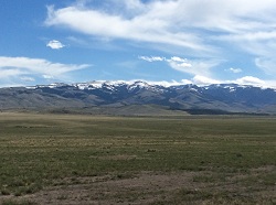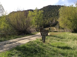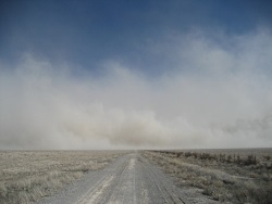
Dust in the Wind

Dust Storm Milford Flats
4 March 2009
US Geological Survey photo by Mark Miller


Hi, I’m Holly Strand of the Quinney College of Natural Resources at Utah State University.

American paleontologist Roy Chapman Andrews was a frequent visitor to the Gobi Desert. This is how he described being caught in a Gobi desert dust storm: “Seemingly a raging devil stood beside my head with buckets of sand, ready to dash them into my face…” “…after each raging attack it would draw off for a few moments’ rest. Then suddenly the storm devil was on us again, clawing, striking, ripping, seeming to roar in fury that any of the tents still stood.”

Andrews didn’t have to go so far to feel the rage of a dust storm. He could have come to western Utah. While we don’t have the monstrous storms of the Sahara and the Gobi/Manchurian deserts, the eastern Great Basin–which is essentially western Utah–sits secure on any global list of dust storm hotspots.

Let’s consider why this is so…

First and foremost, western Utah has the dust. In scientific terms, dust is any particle—organic or inorganic—that is less than .63 microns or smaller in diameter. .63 microns is about half the width of a single human hair. In geological terms think silt or clay particles. A grain of sand is much larger. If you are the size of a dust particle, then a relatively small puff of wind will release you into the air. And you’ll stay there until it’s completely calm or rain forces you down.

A great place to find geologic dust is in desert playas. For runoff sediments collect in these dry lake depressions. Western Utah has several of these desert dust bins. And satellite data have confirmed that playas such as Sevier Dry Lake, Tule Dry Lake, and Great Salt Lake Desert are major sources of dust plumes. The alluvial fans of the Great Basin mountains provide an additional source of dust.

To get this dust airborne you need wind which is also plentiful in western Utah. This region typically experiences strong south and southerwesterly winds called “hatu winds.” That’s Utah spelled backwards. The name was coined by colorful Utah meteorologist Mark Eubank. These hatu winds blow south to north or to the northwest. They pick up speed and dust as they race along the north-south trending Great Basin ridges. They can reach speeds of over 90 miles per hour.

Utah’s hatu winds peak in the spring months with a secondary peak in August-September. In spring these windy freight trains full of dust can hit the populated Wasatch Front wreaking havoc with air quality and human health.

Sometimes raindrops capture dust in the airstream and splat them onto our windshields and windows. These mud rains are most common in spring when the hatus are at their peak. And this is why saavy Utahns never bother washing their home windows until June.

While dust storms can be considered natural events, the fact that they are increasing in number and severity is definitely unnatural. The increase is caused by human-related activities that remove vegetation or break the biological soil crusts that help stabilize dust and soil. Overgrazing, water withdrawals, military operations, farming on marginal lands, off-road vehicle riding, fires, even restoration activities all release dust to be carried off by the next significant wind.

Thanks to Atmospheric Scientist Maura Hahnenberger for her help with this Wild About Utah story.

For Wild About Utah, and the Quinney College of Natural Resources, I’m Holly Strand.

Credits:

Images: Courtesy USGS.gov and NRCS.gov
Sound: Wind sound effect from Sound Bible.com Recorded by Mark DiAngelo https://soundbible.com/1810-Wind.html
Text: Holly Strand

Sources & Additional Reading

Hahnenberger, M. and K. Nicoll. Geomorphic and land use characteristics of dust sources in the eastern Great Basin of Utah, U.S.A. Accepted Geomorphology.

Hahnenberger, M. and K. Nicoll, 2012. Meteorological characteristics of dust storm events in the eastern Great Basin of Utah, U.S.A. Atmospheric Environment, 60, 601-612.

Jason P Field, Jayne Belnap, David D Breshears, Jason C Neff, Gregory S Okin, Jeffrey J Whicker, Thomas H Painter, Sujith Ravi, Marith C Reheis, and Richard L Reynolds The ecology of dust Front Ecol Environ 2010; 8(8): 423–430, doi:10.1890/090050 (published online 12 Oct 2009)https://www.esajournals.org/doi/pdf/10.1890/090050

Neff, J. C., A. P. Ballantyne, G. L. Farmer, N. M. Mahowald, J. L. Conroy, C. C. Landry, J. T. Overpeck, T. H. Painter, C. R. Lawrence, and R. L. Reynolds, 2008: Increasing eolian dust deposition in the western United States linked to human activity. Nature, 1, 189-195

Warner, Thomas T. 2004. Desert Meteorology. NY: Cambridge University Press

Washington, R., M. Todd, N. J. Middleton and A. S. Goudie, 2003. Dust-storm source areas determined by the Total Ozone Mapping Spectrometer and Surface Observations, Annals of the Association of American Geographers, 93(2), 297-313.

Miller, M. E., et al. (2012). “Post-fire land treatments and wind erosion – Lessons from the Milford Flat Fire, UT, USA.” Aeolian Research 7: 29-44.

Steenburgh, W. J., et al. (2012). “Episodic Dust Events of Utah’s Wasatch Front and Adjoining Region.” Journal of Applied Meteorology and Climatology 51(9): 1654-1669.
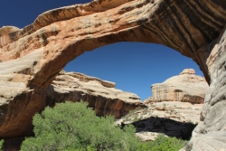
National Park or National Monument?

National Park or National Monument: Sipapu Natural Bridge, Natural Bridges National Monument, Courtesy and Copyright Anna Bengston
Sipapu Natural Bridge
Natural Bridges National Monument
Courtesy & Copyright Anna Bengston

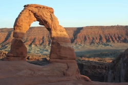
National Park or National Monument: Delicate Arch, Arches National Park, Courtesy and Copyright Anna BengstonDelicate Arch
Arches National Park
Courtesy & Copyright Anna Bengston

Established in 1916 the National Park Service manages all properties included in the National Park System. This system includes over 400 areas that encompass more than 84 million acres of land. These areas can go by one of 31 different titles. Within this system, Utah boasts 1 national historic site, 2 national recreation areas, 7 national monuments, and 5 national parks. While the reason for some of these titles is self-explanatory, the reason for others is less clear. National Park or National Monument?

For example, what makes one area a “national park” and another a “national monument?” Most people – including myself – would probably guess that the difference is in size. And while this is sometimes true, the primary difference is the reason for which each is established, because these two designations grew from historically separate concepts. The notion of the national park, which was simply the idea of large-scale natural preservation for public enjoyment, grew in popularity throughout the 1800s. As a result you can typically think of a national park as a spectacular scenic feature or natural phenomena preserved for inspirational, educational, and recreational value.

On the other hand, the idea of the national monument arose as a result of the need and desire to also protect prehistoric cliff dwellings, pueblo remains, and other historic ruins found by explorers of the American West and Southwest. Efforts to protect these sites resulted in the passing of the Antiquities Act of 1906. Therefore a national monument is usually designated to preserve objects of prehistoric, historic, cultural, and/or scientific interest. However, the Antiquities Act has been used more widely to preserve natural features as well, meaning the content of national monuments can be quite varied from wilderness areas to military sites to buildings and ruins.

There are also a couple of legal differences between these two designations. National parks are established through acts of Congress, whereas national monuments are established by Presidential proclamation. Administratively, the National Park Service manages all national parks. While national monuments, depending on their location and content, can fall under not only under the jurisdiction of the National Park Service, but also that of the U.S. Forest Service, the U.S. Fish and Wildlife Service, the National Oceanic and Atmospheric Administration, the Department of Defense, or the Bureau of Land Management.

So, it’s not just size that makes the difference, its intent, content, process of establishment, and administration. The next time you visit one of Utah’s national parks or monuments, will you be able to tell the difference?

For Wild About Utah, I’m Anna Bengtson of Park City.

Arches National Park
Bryce Canyon National Park
Capitol Reef National Park
Canyonlands National Park
Zion National Park

Golden Spike National Historic Site
Cedar Breaks National Monument
Dinosaur National Monument
Grand Staircase National Monument
Hovenweep National Monument
Natural Bridges National Monument
Pipe Spring National Monument(Border Utah/Arizona)
Rainbow Bridge National Monument
Timpanogos Cave National Monument

Flaming Gorge National Recreation Area
Glen Canyon National Recreation Area

Credits:
Image: Courtesy and Copyright Anna Bengston
Text: Anna Bengston

Additional Reading:

Biggers, Ashley. “National Parks Versus National Monuments.” Outside Online. 22 Apr. 2014. Web. 8 June 2014. https://www.outsideonline.com/adventure-travel/escapes/travel-agent/The-Difference-between-National-Parks-and-National-Monuments.html.

McDonnell, Janet. The national parks: shaping the system. 3rd ed. Washington, D.C.: U.S. Dept. of the Interior, 2005. Web, 8 June 2014. https://www.nps.gov/parkhistory/online_books/shaping/index.htm.

O’Connor, Mary. “Killing A Bill that Could Save National Parks.” Outside Online. N.p., 14 Apr. 2014. Web. 8 June 2014. https://www.outsideonline.com/outdoor-adventure/the-current/footprint/Five-Treasures-We-Owe-to-the-Imperiled-Antiquities-Act.html.

“Parks and Monuments.” Utah. N.p., n.d. Web. 8 June 2014. https://www.visitutah.com/parks-monuments/.

Righter, Robert. “National Monuments to National Parks:
The Use of the Antiquities Act of 1906”, National Park Service History: National Monuments to National Parks. N.p., Aug. 1989. Web. 8 June 2014. https://www.nps.gov/parkhistory/hisnps/npshistory/righter.htm.

United States. National Park Service. “National Park Service History: National Park System Nomenclature.” National Parks Service. U.S. Department of the Interior, n.d. Web. 8 June 2014. https://www.nps.gov/history/history/hisnps/NPSHistory/nomenclature.html.

United States. National Park Service. “Frequently Asked Questions.” National Parks Service. U.S. Department of the Interior, 28 May 2014. Web. 8 June 2014. https://www.nps.gov/faqs.htm.

Yard, Robert Sterling, and Isabelle F. Story. “Parks vs. Monuments.” The national parks portfolio. 6th ed. Washington: U.S. Government Printing Office, 1931. Web, 8 June 2014. https://www.nps.gov/history/history/online_books/portfolio/portfolio0b.htm.

-Wetlands-What’s in a name?

-Wetlands-What’s in a name?

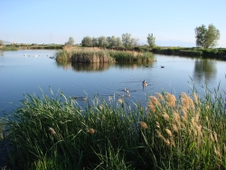
-Wetlands-What's in a name? Click to view larger view of a Pond and marsh showing wetland plants with Canada geese goslings and pelicans. Photo Courtesy and Copyright Mark Larese-Casanova
Pond and marsh showing
wetland plants with
Canada geese goslings and pelicans.
Courtesy & Copyright ©
Mark Larese-Casanova

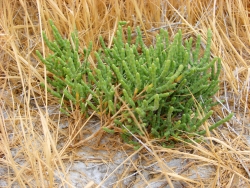
-Wetlands-What's in a name? Click to view larger view of Pickleweed growing in a salt playa is adapted to growing in saline soils. Photo Courtesy and Copyright Mark Larese-Casanova
Pickleweed growing in a salt playa
is adapted to growing in saline soils.
Courtesy & Copyright ©
Mark Larese-Casanova
Hi, this is Mark Larese-Casanova from the Utah Master Naturalist Program at Utah State University Extension.-Wetlands-What’s in a name?

A wetland really is more than just ‘land that is wet’. There are certain key ingredients that need to go into a wetland for it to truly be a wetland. Of course, water needs to be present for at least part of the growing season. It can simply be in the form of temporarily saturated soils or even standing water a few feet deep.

As soil becomes saturated with water, oxygen levels are greatly reduced. Quite often, bacteria in saturated soils will create hydrogen sulfide, giving wetland soils that stinky odor of rotten eggs. As plants grow in a wetland over several years, their decaying matter helps to create a thick, dark layer of organic soil.

The presence of water in a wetland encourages the growth of hydrophytes, or ‘water-loving’ plants, that are specially adapted to living in wet environments. Many wetland plants have open spaces within the leaves and stems- often referred to as aerenchyma. This allows oxygen to diffuse down to the roots, sometimes creating an oxygen-rich environment in the soil around a plant. Also, many wetland plants reproduce both by floating or wind-dispersed seeds and by rhizomes, which are underground roots that can travel great distances. Some plants that grow in salty wetlands around Great Salt Lake are able to control the salt in their tissues by depositing it on the outside of the leaf or containing it in chambers within their cells.

Like plants, specially adapted animals also call wetlands their home. Mammals and birds have oily fur or feathers that allow them to swim in cold water without losing much body heat. They also often have webbed feet to aid in swimming. Other animals, such as fish, amphibians, and insects, have gills to breathe in water.

Despite being the second driest state in the country, Utah has a high diversity of wetlands. Vast marshes surround the Great Salt Lake, providing habitat to enormous populations of migratory birds. Less obvious wet meadows provide unique habitat to butterflies and other insects. Salty playas which are shallow basins with no outlet, are found throughout the West Desert, creating unique ecosystems of highly adapted plants. Riparian wetlands can grow along the edges of rivers, providing a unique transition between the swift water and upland habitats. Southern Utah is home to some peculiar wetlands such as potholes and hanging gardens, both associated with sandstone bedrock. A hanging garden clings to the side of a moist cliff, creating a microhabitat for rare plants, such as orchids and monkeyflower. Potholes can simply be eroded basins in the sandstone where water collects in spring. A pothole is an oasis that provides water for desert wildlife and a home for fairy shrimp and spadefoot toads.

Spring is the perfect time of year to visit a wetland. The constant chorus of birds, insects, and amphibians are a testament to the importance of wetlands, teeming with life in the middle of a desert.

For Wild About Utah, I’m Mark Larese-Casanova.

Credits:

Images: Courtesy & Copyright © Mark Larese-Casanova

Text:     Mark Larese-Casanova, Utah Master Naturalist Program at Utah State University Extension.
Additional Reading:

Mitsch, W.J., and J.W. Gosselink. (1993). Wetlands. Van Nostrand Rheinhold.

Tiner, R. W. (1999). Wetland Indicators: A Guide to Wetland Identification, Delineation, Classification, and Mapping. CRC Press

Utah Division of Wildlife Resources. (1995). Playas to Marshes…Where Water Meets Land. Growing WILD Newsletter. https://www.wildlife.utah.gov/education/newsletters/95spring-gw.pdf

Utah Division of Wildlife Resources. (2003). Utah’s Wonderful Wetlands Activity Guide. https://wildlife.utah.gov/education/pdf/wetlands_activity_guide.pdf

-Wetlands-What’s in a name?

The Raft River Mountains

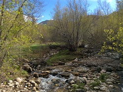
The Raft River Mountains: Clear Creek in Spring
Clear Creek in Spring
Courtesy & Copyright Holly Strand

The Raft River Mountains: Raft River MountainsRaft River Mountains
Courtesy & Copyright Holly Strand

The Raft River Mountains: Near Clear Creek Campground.Near Clear Creek Campground.
Courtesy & Copyright Holly Strand


Hi, I’m Holly Strand of the Quinney College of Natural Resources at Utah State University.

In each of Utah’s six corners you’ll find one or more remarkable natural features. Moreover, each corner represents a totally different geographic environment. No doubt you are familiar with turquoise blue Bear Lake in the upper northeast and the magnificent High Uintas near the angle formed by Wyoming. Flaming Gorge and Dinosaur National Monument flank the lower northeast corner. The ancient ruins and Monument Valley draw international visitors to the southeast corner. The numerous canyon parks in Utah’s southwest corner offer endless opportunities for exploration. 

That’s five corners. But what do you know about the northwest corner of our state? I live in Northern Utah and I had never been there. Resolved to correct this omission I consulted a map as well as Joan Hammer of Box Elder County’s Office of Tourism. I concluded that the Raft River Mountains were worth checking out. The highest point in the County, Bull Mountain is here. And the 40 mile long range defines the southernmost section of Sawtooth National Forest.

The Raft River Mountains are unusual in that they run east-west. The normal pattern for Basin and Range country is north-south. The east-west orientation creates an important geographic dividing line. For Clear Creek drains the northern slopes of the Raft River Mountains. Then Clear Creek joins the Raft River which flows north to the Snake River. Thus the mountains form the sole—and very small—piece of Utah real estate that belongs to the great Colombia River Basin. The southern slopes are part of Great Basin. Rain or snow falling on this side is absorbed into the ground or evaporates.

Another interesting fact: The Raft River Mountains is where you can view some of the oldest rock in Utah. In this region, outcrops of Precambrian material are 2.5 billion years old. The largest and thickest exposures are in the eastern half of the range.

The Raft River Mountain peaks may not make it onto post cards. But when I saw them they were nothing less than beautiful. The lower slopes of sagebrush had the grayish-green tint that emerges all too briefly in the spring. Snow still gleamed on the 8-9000 foot summits. Clear Creek was running full through riparian forest that was just starting to leaf out. There were no people at the campground but wildlife was plentiful. I saw wild turkey, deer, jackrabbits and squirrels. A few pronghorn looked up as I drove out through the sagebrush. All in all, I found Utah’s sixth corner to be well worth a visit.

For pictures and more information about the Raft River Mountains, go to www.wildaboututah.org

For Wild About Utah, and the Quinney College of Natural Resources, I’m Holly Strand.

Credits:

Images: Courtesy and Copyright Holly Strand
Text: Holly Strand

Additional Reading

Doelling, Hellmut H. Geology and Mineral Resources of Box Elder County. Utah Geological and Mineral Survey. 1980. Bulletin 115.,

Stokes, William Lee. 1988. Geology of Utah. Salt Lake City: Utah Museum of Natural History. SummitPost.org Bull Mountain. https://www.summitpost.org/bull-mtn-ut/183282https://www.summitpost.org/bull-mtn-ut/183282 [Accessed May 13, 2014 and July 10, 2020]

USDA Forest Service. Sawtooth National Forest, Raft River Division. https://www.fs.usda.gov/recarea/sawtooth/recarea/?recid=5806 [Accessed May 13, 2014 and July 10, 2020]

Hylland, Rebecca, What are Igneous, Sedimentary & Metamorphic Rocks?, Glad You Asked, Utah Geological Survey, https://geology.utah.gov/map-pub/survey-notes/glad-you-asked/igneous-sedimentary-metamorphic-rocks/