Investigating the Causes of Wildfires

Investigating the Causes of Wildfires: A wildfire near Hyrum, UT, Courtesy & Copyright 2013 Holly Strand, Photographer

Wildfire near Hyrum, UT
Showing Fixed-Wing Retardant Drop
Courtesy & Copyright 2013
Holly Strand, Photographer

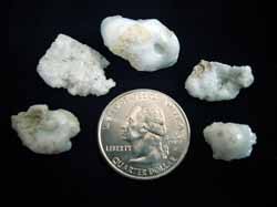
Fulgurites, caused by lightning
Courtesy Wikimedia Commons,
John Elson, Photographer
Licensed under GNU Free Documentation License v 1.2

Utah Sand Fulgurites
Found on Mount Raymond
Courtesy Utah Geological Survey
Carl Ege, Photographer

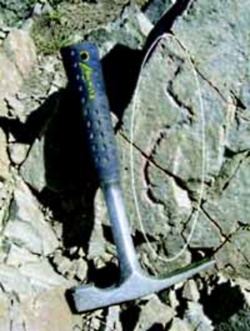
Rock Fulgurite (circled)
Found on quartzite at the summit of
Mount Raymond, Wasatch Range,
Salt Lake County, UT.
Courtesy Utah Geological Survey
Carl Ege, Photographer

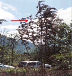
‘Frozen’ leaves pointing in the direction of prevailing winds during the passage of the fire.
From the ‘Wildfire Origin & Cause Determination Handbook’
Courtesy National Wildfire Coordinating Group(NCGW.gov)

Hi I’m Holly Strand of Utah State University’s College of Natural Resources.

It’s fire season in UT. The hill slopes have turned a parched yellow-brown and the trees look thirsty and flammable. As of Aug. 13, there were 7 fires burning across the state.

One of the first questions that arises with any wildfire is “What started it?”

And I wonder: “How in the world would you figure this out given the destruction that a fire leaves in its wake?”

The first step toward identifying a cause involves finding the exact spot where the fire started. To do this, investigators look for witnesses. And having information on wind direction for the duration of the fire helps a lot. But even in the absence of these, the fire itself leaves clues regarding the direction of movement. And if you know the direction of movement, you can trace the path backwards to the ignition site.

For instance, on a tree or post, the side exposed to the oncoming fire will show deeper charring, more loss of wood and more white ash than the unexposed side.

However the leeward side of a tree may have the highest char mark. That’s because as strong winds blows the fire past a tree, the flames are drawn into the eddy zone on the leeward side and extend higher up the trunk. Still, the deeper char will be on the side facing the advancing flame. So to get to the area of the fire origin, you’d want to follow direction indicated by the most damaged tree face.

When green leaves of shrubs or trees are scorched, they tend to become soft and pliable and bend in the direction of the prevailing wind. After the fire passes they become fixed in this position as they cool, still pointing in the direction of the wind. So the opposite direction of the pointing leaves will take you closer to the fire origin.

Another thing that generally helps fire investigators is the fact that all fires need time to achieve their maximum spread rate/intensity. A newly ignited fire may take 30 min or more to ramp up. As a result even with high intensity fires, the area of initial ignition will show relatively less damage; upper foliage and branches may even remain intact.

Once the area of origin is identified, investigators look for the human or natural source of the blaze. Footprints, tire marks or evidence of a campfire are noted with interest. Nearby power lines, railroad tracks or electric fences may have provided the initial spark. Investigators often end up on their hands and knees searching for things such as cigarette parts, ignitable liquid residue; bullets or empty shell casings.

If lightening is a suspected source investigators look for strike marks or splintered wood fragments. Lightening can also leave a glassy residue, called a fulgurite, when the strike melts sand on the ground or on vegetation.

Thanks to Wesley Page of USU’s Department of Wildland Resources for sharing his wildfire expertise.

For sources and more information on investigating the cause of wildfires go to www.wildaboututah.org

For Wild About Utah and USU’s College of Natural Resources, I’m Holly Strand.

Credits:

Images: Hyrum Fire, Courtesy & Copyright 2013 Holly Strand
Courtesy Wikimedia, John Elson, Licensed under GNU Documentation License V1.2
Also images from Wildfire Origin & Cause Determination Handbook, Courtesy National Wildfire Coordinating Group(NCGW.gov)
Text: Holly Strand

Sources & Additional Reading

Cheney, Phil and Andrew Sullivan. Grassfires: Fuel, weather and fire behavior. 2008. CSIRO. https://www.amazon.com/Grassfires-Fuel-Weather-Fire-Behaviour/dp/0643093834

Wildfire Origin & Cause Determination Handbook. 2005. A publication of the National Wildfire Coordinating Group Fire Investigation Working Team NWCG Handbook 1. PMS 412-1. May 2005. https://www.nwcg.gov/pms/pubs/nfes1874/nfes1874.pdf

Investigating Wildfires: Part One. Interfire online. https://www.interfire.org/features/wildfires.asp
(accessed August 14, 2013)

Investigating Wildfires: Part Two. Interfire online. https://www.interfire.org/features/wildfires2.asp
(accessed August 14, 2013)

Map of current large active wildland fires in Utah.
(accessed August 14, 2013) https://www.utahfireinfo.gov/

Live Worldwide Network for Lightning and Thunderstorms in Real Time, Blitzortung, https://en.blitzortung.org/live_lightning_maps.php?map=30 [URL inactive as of 1 Aug 2020}]
Utah’s Water Future

70% of our planet is covered in water, but you certainly wouldn’t know it by looking around Utah in August! It’s been hot and dry for about 3 months now and my yard and garden are really starting to feel the pinch.

Water can be a touchy subject in the West, and will become increasingly so as we look to the future.

Already our water resources are overextended, and all projected forecasts show an increasing need for water in the years ahead. Continued population growth combined with higher summer temperatures and drought conditions mean that this all important resource is only going to get more precious. Utah’s municipal water comes from either underground sources such as wells and springs or surface water including our many man-made reservoirs. Utah relies heavily on mountain snowpack to fill reservoirs and recharge springs, which leaves us wanting after weak winters. Many state reservoirs are predicted to drop to as low as 30% of their storage capacity this fall.

So how much water do we actually use? The average Utah household passes 650 gallons through its pipes each day, the vast majority of which goes towards bathing, toilets, and laundry. Household water use is of course only a fraction – about 13% – of our overall state consumption. Nearly 83% of the water used in Utah goes towards crop irrigation. Agricultural use plus household and industrial water add up to an astonishing 5 billion gallons of water used in the state of Utah each and every day. Per capita, Utah ranks 2

Utah is also the second driest state in the nation, again behind Nevada, though the amount of precipitation varies widely among our deserts and mountain ranges. On average, we receive around 13 inches of water each year across the state with some areas receiving less than 10 and others upwards of 50. All of that water has to be shared among the plants, animals, and humans living in each watershed. There are, of course, lots of ways to conserve water in the home: take shorter showers, run the washing machine or dishwasher only when full, and turn off the faucet while brushing teeth. Outside, water your lawn and garden only in the late evening, overnight, or early morning hours, but check the forecast first. In order to address our widespread and long-term water issues, however, bigger solutions are needed in addition to standard household water conservation. Last year, for example, the Bill & Melinda Gates Foundation sponsored a contest to reinvent the toilet in an attempt to save water and increase sanitation for people worldwide.

Governor Gary Herbert is also asking questions about Utah’s water this summer. He has convened a handful of meetings around the state to contemplate Utah’s Water Future, and is asking for public comments and suggestions on how to address the complicated issues that will face our state with regards to water use in the coming years. The last of these public meetings are being held in Salt Lake on August 13 and in Logan on August 15 can still add your comments and ideas to the record by visiting utahswaterfuture.org. Humans are an incredibly creative and adaptable species, and it will take our best efforts to overcome this daunting challenge. The future of this great state, and all the species who call it home, depend upon it.

Find links to the Governor’s water forum as well as more information on Utah’s water resources at our website: www.wildaboututah.org.

For the Stokes Nature Center and Wild About Utah, this is Andrea Liberatore.

Credits:

Photos: Courtesy & © Andrea Liberatore
Text:    Andrea Liberatore, Stokes Nature Center, logannature.org

Additional Reading:

Utah Division of Water Resources. https://www.water.utah.gov/

Utah Division of Water Resources (2010) Municipal and Industrial Water Use in Utah: Why do we
use so much water when we live in a desert? Available online at https://water.utah.gov/M&I/PDF/State/2010%20M_I%20Statewide%20SummaryCH.pdf

Governor Herbert’s forum: Utah’s Water Future: www.utahswaterfuture.org
Utah State University Water Quality Extension: https://extension.usu.edu/waterquality/

O’Donoghue, Amy Joi. (2013) Record Breaking Heat and Drought Sear Utah and the West. Desert
News, June 30, 2013. Available online at: https://www.deseretnews.com/article/865582439/Recordbreaking-heat-drought-sear-Utah-the-West.html?pg=all

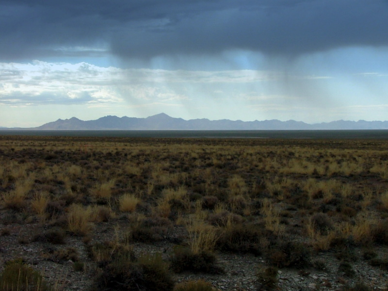
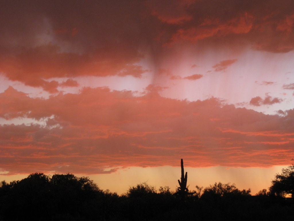
Virga

Virga courtesy and Copyright 2010 Kevin Connors
Virga
Courtesy & Copyright 2010 Kevin Connors
August is the perfect month to observe virga in Utah, for it is the monsoon season here. Moist subtropical air is flowing northward from the Pacific Ocean and the Gulf of California. When this warm, moist air is driven upward by convection and mountains, towering thunder heads result.

Below the bellies of these dark clouds you sometimes see grayish windswept curtains or streamers that do not reach the ground. Meteorologists call them “virga”, virga spelled with an “i”, from the Latin for “streak”. The word is absent from the prose of Mark Twain and the exploratory reports of John Wesley Powell because the word was only coined 70 years ago.

Click to view information from the : Virga in Cache Valley courtesy and Copyright 2010 Jim Cane
Virga in Cache Valley
Courtesy & Copyright 2010 Jim Cane

These picturesque virga are descending precipitation. One might guess it to be rain, but most meteorologists agree that it is frozen precipitation which is melting and evaporating as it drops through our dry Utah air. Like a home swamp cooler, evaporation causes cooling which leads to the chilly downdrafts that accompany our summer thunderstorms. In the humid tropics, rains can be lukewarm, but our summer cloudbursts are goose-bump cold, owing to the same evaporation which yields virga.

Virga are a tease for parched summer landscapes, a herald of wild fires ignited by dry lightning, and a generator of dust storms as downdrafts scour dusty salt flats. But mostly, the curtains of precipitation that are virga are a fleetingly beautiful element of our western summer skies, well worth a pause and a picture, especially if you are lucky enough to see one accompanied by a rainbow or a fiery sunset.

Click to view a larger picture of Virga in Tucson, AZ Courtesy & Copyright 2010 Julio Betancourt, Photographer
Virga in Tucson, AZ
Courtesy & Copyright 2010 Julio Betancourt

This is Linda Kervin for Bridgerland Audubon Society.
Credits:

Photos: Courtesy & Copyright 2010 Jim Cane
Courtesy & Copyright 2010 Julio Betancourt
Text: Jim Cane, Bridgerland Audubon Society

Additional Reading:

Jetstream, an online school for weather, NWS NOAA Southern Regional Headquarters, Ft worth, TX,
https://www.weather.gov/jetstream/atmos_intro

Virga in Tucson, AZ Courtesy & Copyright 2010 Julio Betancourt, Photographer
Virga in Tucson, AZ
Courtesy & Copyright 2010 Julio Betancourt

Fire weather: a guide for application of meteorological information to forest fire control operations, Mark J. Schroeder and Charles C. Buck, USDA Forest Service, https://training.nwcg.gov/pre-courses/S390/FireWeatherHandbook
/pms_425_Fire_Wx_ch_01.pdf

The Book of clouds, John A. Day, Sterling, 2005, https://www.amazon.com/Book-Clouds-John-Day/dp/1402728131

Live Worldwide Network for Lightning and Thunderstorms in Real Time, Blitzortung, https://en.blitzortung.org/live_lightning_maps.php?map=30 [Broken link removed 1 Aug 2020]

Oolites

Click to view larger image of the Utah's Oolitic Sand, Photo Courtesy and Copyright Mark Larese-Casanova
Utah’s Oolitic Sand, Photo Courtesy and Copyright Mark Larese-Casanova

Hi, this is Mark Larese-Casanova from the Utah Master Naturalist Program at Utah State University Extension.

Imagine if prehistoric brine shrimp were responsible for one of the finest examples of architecture in Salt Lake City today.

Okay, so it may be a bit of a stretch, but let me explain. In a previous episode of Wild About Utah, I discussed the life cycle of brine shrimp and the important role that they play in the Great Salt Lake Ecosystem. Well, as the billions of brine shrimp feed on bacteria in Great Salt Lake, they excrete waste in the form of tiny fecal pellets. These pellets, along with sand grains and other bits of debris, eventually settle to the bottom of Great Salt Lake.

In shallow areas of the lake, where wind and waves routinely mix the water, these small particles gradually accumulate layers of calcium carbonate, forming an oolite (spelled o-o-l-i-t-e). This is very similar to how a pearl, also layers of calcium carbonate around a small particle, is formed within the shell of an oyster or mussel. The main difference, aside from a pearl being much larger, is that oolites are typically oblong, rather than round. The beaches on the west side of Antelope Island are a great place to find oolitic sand, which will look and feel as though you have a handful of tiny pearls.

Click to view larger image of the Utah's Oolitic Sandstone, Photo Courtesy and Copyright Mark Larese-Casanova
Utah’s Oolitic Sandstone
Photo Courtesy & Copyright
Mark Larese-Casanova

Around 50 million years ago, large fresh- and salt-water lakes covered parts of Utah, and in these areas, vast amounts of sediments, including oolites, were deposited. Over time, these oolites were compressed and cemented together into limestone.

A quarry near Ephraim in Sanpete County supplied oolitic limestone for the construction of the Governor’s Mansion in 1902 and the original Salt Lake City Public Library in 1905. The Library building, located at 15 South State Street, eventually housed the Hansen Planetarium and is now home to the O.C. Tanner flagship store. The building underwent an extensive restoration just a couple of years ago, and now serves as a shining example of neoclassical architecture in our capitol city.

The truth is, there are tens of millions of years separating oolitic limestone from our modern-day brine shrimp. So, we can’t exactly say that prehistoric brine shrimp were responsible for the existence of the O.C. Tanner building. But, it’s fun to imagine precious gems from around the world housed in a beautiful building constructed from the ‘pearls’ of Great Salt Lake.

Click to view larger image of the historic OC Tanner building made from oolitic sandstone (This building formerly housed the Salt Lake Library and Hansen Planetarium), Photo Courtesy and Copyright Mark Larese-Casanova
Historic OC Tanner Building
(formerly the Salt Lake Library
and later the Hansen Planetarium)
Photo Courtesy & Copyright
Mark Larese-Casanova

For Wild About Utah, I’m Mark Larese-Casanova.
Credits:

Images: Courtesy and copyright Mark Larese-Casanova

Text:     Mark Larese-Casanova, Utah Master Naturalist Program at Utah State University Extension.
Additional Reading:

Utah Geological Survey https://geology.utah.gov/utahgeo/rockmineral/collecting/oolitic.htm

Utah Division of Wildlife Resources, Great Salt Lake Ecosystem Program
https://wildlife.utah.gov/gsl/facts/oolitic_sand.php

Salt Lake Brine Shrimp, https://saltlakebrineshrimp.com/harvest/