Wildfires

Wildfires: Smoke roils from 2012 wildfire in Utah. Photo by U.S. Forest Service.
Smoke roils from 2012 wildfire in Utah. Photo by U.S. Forest Service.

Wildfires hit record highs this year in the Western U.S. There can be arguments blaming Climate Change or Forest Management. Were they caused by human carelessness or natural causes such as lightning? Take your pick. But the results were tragic.

Through August this year, Utah has had nearly 1,300 fires which burned nearly a quarter million acres and cost $100 million dollars.

Nationally, 90% of wildfires are human-caused from unattended campfires, discarded cigarettes, mismanaged debris fires and planned acts of arson. And the cost of those fires exceeded $5 billion dollars over the last 10 years. From January to August in 2018 there were nearly 39,000 different fires that burned over 5 million acres.

Much has been said about those tragic statistics that affect the loss of human life, the destruction of developed properties, the discomforts of evacuations, and the enormous costs and dangers of fighting fires as the horrible results of these runaway infernos. But, what about next year? Will the drought continue? Will the climate continue to set record temperatures?

Burned Stumps & Ashes Courtesy & Copyright Friend Weller, Photographer
Burned Stumps & Ashes
Courtesy & Copyright Friend Weller, Photographer

One of the consequences that has not been discussed much is the loss of millions of trees. What can we expect when living trees are turned into burned stumps and ashes?

The major greenhouse gas in our atmosphere is Carbon Dioxide. It is called a green house gas because it warms the earth’s temperature. Carbon dioxide is produced by the burning of fossil fuels or trees, chemical reactions such as the manufacture of cement, and the exhaling of animals. It is removed from the atmosphere when it is absorbed by land-plants and the ocean as part of the biological carbon cycle. The role the ocean plays in the carbon cycle is a topic for another program.

It is the loss of trees that we will consider now.
I will mention only a few of the many benefits trees provide.

You may recall from biology class that the trees take-in carbon dioxide and release oxygen. Forest fires require oxygen to burn, and we require oxygen to live. This year, we have already lost 5 million acres of oxygen production.

There are trees, such as the Lodgepole Pine, which have serotinous cones which release their seeds during the intense heat of forest fires. But it will take 40 years for those seeds to
grow into mature trees.

Another consideration is the loss of trees along hillsides and mountain slopes. When rain or snow hits those barren areas there can be massive soil erosion. This not only pollutes the streams and rivers below, but eliminates the top layer of soil where new seeds would best survive.

Besides the loss of human homes, there is the loss of wildlife habitat to consider. IF animals were able to escape massive fires, they must then find suitable habitat, which may encroach on human developments.

Then there is the loss of shade. Barren land will be more susceptible to collecting heat from the sun’s rays, which then will cause more heating of the atmosphere.

So, what can we do about this? First, be extremely careful with fire; Second, plant trees in your communities; Third, contact your local Ranger District or U.S. Forest Service to see if you can volunteer in tree planting projects.

This is Ron Hellstern, and I am Wild About Utah.
 
Credits:

Images: Courtesy USDA Forest Service,
https://www.srs.fs.usda.gov/compass/2013/05/28/climate-change-and-wildfire/
Audio: Contains audio courtesy
Freesound.org, Sound provided by Dynamicell
https://freesound.org/people/Dynamicell/sounds/17548/
Text: Ron Hellstern, Cache Valley Wildlife Association

Job & Volunteering

USDA Forest Service Offices:
Region 4: Intermountain Region
Federal Building
324 25th Street
Ogden, UT 84401
801-625-5605
[Job & Volunteering] Connections, https://www.fs.usda.gov/main/r4/jobs
Volunteer Opportunities, https://www.fs.usda.gov/main/r4/jobs/volunteer

Volunteer, TreeUtah, https://treeutah.org/volunteer/

Outka-Perkins, Lisa, Welcome to the Forest Service: A Guide for Volunteers, USDA Forest Service, Feb 2009,
https://www.fs.fed.us/t-d/pubs/pdfpubs/pdf09672813/pdf09672813dpi72.pdf

Additional Reading

Boling, Josh, Fire, Wild About Utah, August 13, 2018, https://wildaboututah.org/fire/

Strand, Holly, Investigating the Causes of Wildfires, Wild About Utah, Aug 15, 2013, https://wildaboututah.org/investigating-the-causes-of-wildfires/

Larese-Casanova, Mark, Wildfires in Utah, Wild About Utah, July 26, 2012, https://wildaboututah.org/wildfires-in-utah/

Preparing Home and Property for Wildlife, A Proactive Approach, Utah Living With Fire, Salt Lake City, UT, https://www.utahlivingwithfire.com/

Live Worldwide Network for Lightning and Thunderstorms in Real Time, Blitzortung, https://en.blitzortung.org/live_lightning_maps.php?map=30
Investigating the Causes of Wildfires

Investigating the Causes of Wildfires: A wildfire near Hyrum, UT, Courtesy & Copyright 2013 Holly Strand, Photographer

Wildfire near Hyrum, UT
Showing Fixed-Wing Retardant Drop
Courtesy & Copyright 2013
Holly Strand, Photographer

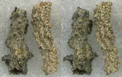
Fulgurites, caused by lightning
Courtesy Wikimedia Commons,
John Elson, Photographer
Licensed under GNU Free Documentation License v 1.2

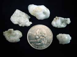
Utah Sand Fulgurites
Found on Mount Raymond
Courtesy Utah Geological Survey
Carl Ege, Photographer

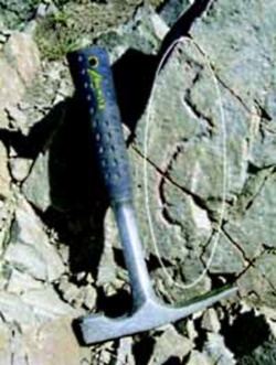
Rock Fulgurite (circled)
Found on quartzite at the summit of
Mount Raymond, Wasatch Range,
Salt Lake County, UT.
Courtesy Utah Geological Survey
Carl Ege, Photographer

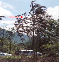
‘Frozen’ leaves pointing in the direction of prevailing winds during the passage of the fire.
From the ‘Wildfire Origin & Cause Determination Handbook’
Courtesy National Wildfire Coordinating Group(NCGW.gov)

Hi I’m Holly Strand of Utah State University’s College of Natural Resources.

It’s fire season in UT. The hill slopes have turned a parched yellow-brown and the trees look thirsty and flammable. As of Aug. 13, there were 7 fires burning across the state.

One of the first questions that arises with any wildfire is “What started it?”

And I wonder: “How in the world would you figure this out given the destruction that a fire leaves in its wake?”

The first step toward identifying a cause involves finding the exact spot where the fire started. To do this, investigators look for witnesses. And having information on wind direction for the duration of the fire helps a lot. But even in the absence of these, the fire itself leaves clues regarding the direction of movement. And if you know the direction of movement, you can trace the path backwards to the ignition site.

For instance, on a tree or post, the side exposed to the oncoming fire will show deeper charring, more loss of wood and more white ash than the unexposed side.

However the leeward side of a tree may have the highest char mark. That’s because as strong winds blows the fire past a tree, the flames are drawn into the eddy zone on the leeward side and extend higher up the trunk. Still, the deeper char will be on the side facing the advancing flame. So to get to the area of the fire origin, you’d want to follow direction indicated by the most damaged tree face.

When green leaves of shrubs or trees are scorched, they tend to become soft and pliable and bend in the direction of the prevailing wind. After the fire passes they become fixed in this position as they cool, still pointing in the direction of the wind. So the opposite direction of the pointing leaves will take you closer to the fire origin.

Another thing that generally helps fire investigators is the fact that all fires need time to achieve their maximum spread rate/intensity. A newly ignited fire may take 30 min or more to ramp up. As a result even with high intensity fires, the area of initial ignition will show relatively less damage; upper foliage and branches may even remain intact.

Once the area of origin is identified, investigators look for the human or natural source of the blaze. Footprints, tire marks or evidence of a campfire are noted with interest. Nearby power lines, railroad tracks or electric fences may have provided the initial spark. Investigators often end up on their hands and knees searching for things such as cigarette parts, ignitable liquid residue; bullets or empty shell casings.

If lightening is a suspected source investigators look for strike marks or splintered wood fragments. Lightening can also leave a glassy residue, called a fulgurite, when the strike melts sand on the ground or on vegetation.

Thanks to Wesley Page of USU’s Department of Wildland Resources for sharing his wildfire expertise.

For sources and more information on investigating the cause of wildfires go to www.wildaboututah.org

For Wild About Utah and USU’s College of Natural Resources, I’m Holly Strand.

Credits:

Images: Hyrum Fire, Courtesy & Copyright 2013 Holly Strand
Courtesy Wikimedia, John Elson, Licensed under GNU Documentation License V1.2
Also images from Wildfire Origin & Cause Determination Handbook, Courtesy National Wildfire Coordinating Group(NCGW.gov)
Text: Holly Strand

Sources & Additional Reading

Cheney, Phil and Andrew Sullivan. Grassfires: Fuel, weather and fire behavior. 2008. CSIRO. https://www.amazon.com/Grassfires-Fuel-Weather-Fire-Behaviour/dp/0643093834

Wildfire Origin & Cause Determination Handbook. 2005. A publication of the National Wildfire Coordinating Group Fire Investigation Working Team NWCG Handbook 1. PMS 412-1. May 2005. https://www.nwcg.gov/pms/pubs/nfes1874/nfes1874.pdf

Investigating Wildfires: Part One. Interfire online. https://www.interfire.org/features/wildfires.asp
(accessed August 14, 2013)

Investigating Wildfires: Part Two. Interfire online. https://www.interfire.org/features/wildfires2.asp
(accessed August 14, 2013)

Map of current large active wildland fires in Utah.
(accessed August 14, 2013) https://www.utahfireinfo.gov/

Live Worldwide Network for Lightning and Thunderstorms in Real Time, Blitzortung, https://en.blitzortung.org/live_lightning_maps.php?map=30 [URL inactive as of 1 Aug 2020}]