The Great Salt Lake

The Great Salt Lake Breach
Courtesy U.S. Geological Survey
Department of the Interior/USGS
Mike Freeman, Photographer
10 Nov 2015
Water flowing through the Great Salt Lake breach in 2011, when lake levels were high due to above average snowfall in the Wasatch and Uinta Mountains. The Great Salt Lake breach is an area that allows water to travel between the southern and northern parts of the lake.
There is a giant among us with a profound influence on our past, present, and future. My first encounter with this giant was both buoyant and delightful as I floated in the brine on a lovely summer day. But I was oblivious to the Great Salt Lake’s immense value as an environmental, cultural, and economic resource.

Much of what follows is taken from a very recently released collaborative study titled “Impacts of Water Development on Great Salt Lake and the Wasatch Front” which was a collaborative effort from four institutions(Utah State University, Utah Division of Water Resources, Salt Lake Community College, and the Utah Division of Wildlife Resources.)

A 2012 analysis by Bioeconomics estimated the economic value of the lake at $1.32 billion per year for mineral extraction, brine shrimp cyst production, and recreation. The abundant food and wetlands of the lake attract 3 million shorebirds, as many as 1.7 million eared grebes, and hundreds of thousands of waterfowl during spring and fall migrations. Because of this, it has been designated as a Western Hemisphere Shorebird Reserve Network Site. Due to its enormous surface area, it produces the “lake affect” which enhances our snow pack by an estimated 8%, a significant amount for both skiers and our available water. But our giant is shrinking.

Since the arrival of 19th Century pioneers water diversions for irrigation have decreased its elevation by 11 feet exposing much of the lake bed. Natural fluctuations in rainfall and river flow cause the lake level to rise and fall, but there has been no significant long‐term change in precipitation and water supply from the main tributaries since their coming in 1847.

The Great Salt Lake Breach 2015
The Great Salt Lake Breach
Credit: U.S. Geological Survey
Department of the Interior/USGS
Mike Freeman, Photographer
10 Nov 2015

For the first time since it was opened in 1984, water has stopped flowing through the Great Salt Lake causeway breach, an area that allows water to travel between the southern and northern parts of the lake.
To significantly reduce water use, a balanced conservation ethic needs to consider all uses, including agriculture, which consumes 63 percent of the water in the Great Salt Lake Basin. There are no water rights to protect our Great Lake, so water development currently focuses solely on whether there is water upstream to divert. If future water projects reduce the supply of water to the lake, (such as the Bear River Development Project, its level will (most likely) continue to drop.

We must look beyond the next few decades and decide how we value the lake for future generations. Lower lake levels will increase dust pollution and related human health impacts, and reduce industrial and environmental function of Great Salt Lake. We must be willing to make decisions now that preserve Great Salt Lake’s benefits and mitigate its negative impacts into the coming centuries.

John Muir, one of my favorite early American naturalists would most certainly agree with me. From his baptismal plunge into the Great Salt Lake. “I found myself undressed as someone else had taken me in hand and got myself into right lusty relationship with the brave old lake. I was conscious only of a joyous exhilaration….”
And where else could John and I have such a wonderfully buoyant experience?

This is Jack Greene reading for Wild About Utah.

2015 Great Salt Lake Breach at Lakeside, Utah
Gauge near the Great Salt Lake Breach
Credit: U.S. Geological Survey
Department of the Interior/USGS
Mike Freeman, Photographer
10 Nov 2015
A gauge to measure lake water levels stands dry in the lake bed of the Great Salt Lake. For the first time since it was opened in 1984, water has stopped flowing through the Great Salt Lake causeway breach, an area that allows water to travel between the southern and northern parts of the lake.
Credits:
Image: Courtesy U.S. Department of the Interior, U.S. Geological Survey(USGS), gallery.usgs.gov
Text:     Jack Greene, Bridgerland Audubon Society & USU Office of Sustainability

Additional Reading:

Great Salt Lake, Utah, Stephens, Doyle W. and Gardner, Joe, USGS Science for a Changing World, https://pubs.usgs.gov/wri/wri994189/PDF/WRI99-4189.pdf

Salt Lake Brine Shrimp, https://saltlakebrineshrimp.com/harvest/

Great Salt Lake Footprint 2001 vs 2003 Comparison
Great Salt Lake Footprint Comparison
2001 vs 2003
Images Courtesy NASA
NASA’s Earth Observatory
Irruptive Birds Migrate South

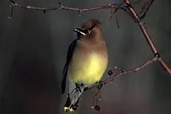
Cedar Waxwing
Cedar Waxwing US FWS FWS Digital Library, David Menke, Photographer
Every winter, many of Utah’s breeding birds migrate south to avoid the cold. After the warblers, tanagers, and orioles leave each fall, we share the snowy winter with hardier residents, such as chickadees, nuthatches, and juncos. But even hardier birds breed in the far north and venture south to Utah only during the most severe winters.

CEDW call, Western Soundscape Archive; University of Utah, Audio file copyright 2007, Kevin Colver. All rights reserved

Many people are familiar with the high, thin calls of Cedar Wawings. Less frequently heard in Utah are the slightly lower calls of their close cousins, Bohemian Waxwings.

Bohemian Waxwings(BOWA) call, Western Soundscape Archive; University of Utah, Audio file copyright 2007, Kevin Colver. All rights reserved

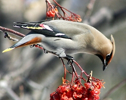
Bohemian Waxwing
Bohemian Waxwing, licensed under the Creative Commons Attribution-Share Alike 2.0 Generic license. Source Wikimedia.org, Randen Pederson, Photographer.
Bohemian Waxwings are slightly larger than Cedar Waxwings, and a little fancier—their wing feathers include red, yellow, black, and white, and the underside of their tails is a rich cinnamon. Both species gather by the hundreds to eat berries, so you won’t miss a flock if there’s one nearby. Although waxwings are songbirds, the calls you hear don’t serve the same functions as true songs, advertising mate quality and defending territories. Instead, waxwings cooperate to find and feed on scattered fruit, their main winter diet. Unlike most birds, waxwings are able to smell, which may help them find their food. If waxwings eat berries that have begun to ferment over the winter months, they may become intoxicated even though their ability to metabolize ethanol is very high. The last time Bohemian Waxwings were abundant in Utah was during the winter of 2012-2013.

White-winged Crossbill(WWCR) call, Western Soundscape Archive; University of Utah, Audio file copyright 2007, Kevin Colver. All rights reserved

If you look in a pine tree, you may see a flock of White-winged Crossbills. Last abundant in Utah during the winter of 2008-2009, this species of finch forages on the seeds inside of conifer cones.

White-winged Crossbill, Courtesy and Copyright Paul Higgins, www.pbase.com/phiggins/
White-winged Crossbill
Copyright © 2009 Paul Higgins
More photos at pbase.com/phiggins/
and utahbirds.org Photo Gallery
As the name crossbill suggests, the lower part of its bill is bent to the right and the upper part to the left, allowing crossbills to wedge open pinecone scales and lift the seeds free with their tongues. In the winter, crossbills forage in flocks of ten to fifty. They quickly assess the quality of a tree’s cones, using visual and vocal cues from their flockmates, which are quiet when they are eating but chatter when they are not. When the volume of the chatter increases to a crescendo, all the crossbills in the flock know that it’s time to switch to a new tree. Unlike most songbirds, crossbills can breed at any time of year, as long as conifer seeds are abundant.

When the weather gets cold, keep an eye and an ear out for these winter nomads.

For Wild About Utah, I’m Andrew Durso.

Credits:

Waxwing Images: Courtesy US FWS, David Menke, Photographer
White-winged Crossbill Image: Courtesy and Copyright © 2009 Paul Higgins, Photographer
Text: Andrew Durso, https://www.biology.usu.edu/htm/our-people/graduate-students?memberID=6753

Additional Reading:

Fitting the Bill, Andrea Liberatore, August 11, 2011, https://wildaboututah.org/fitting-the-bill/

White-winged Crossbill, All About Birds, Cornell Lab of Ornithology, https://www.allaboutbirds.org/guide/White-winged_Crossbill/id

Cedar Waxwing, All About Birds, Cornell Lab of Ornithology, https://www.allaboutbirds.org/guide/Cedar_Waxwing/id

Bohemian Waxwing, All About Birds, Cornell Lab of Ornithology, https://www.allaboutbirds.org/guide/Bohemian_Waxwing/id

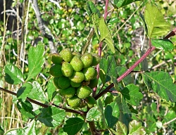
Three-leaf Sumac

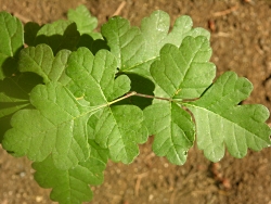
Three-Leaf-Sumac Rhus-trilobata, Photo courtesy Hansen's Northwest Native Plant Database, nwplants.com, Licensed Creative Commons Attribution-ShareAlike 3.0 Unported License
Three-Leaf-Sumac Rhus-trilobata
Photo courtesy Hansen’s Northwest Native Plant Database, nwplants.com Licensed under Creative Commons Attribution-ShareAlike 3.0 Unported License
Many think of the desert as a hot, dry, barren, and unforgiving place. However, Utah’s deserts are chock full of interesting and diverse plants and animals! One such plant, which grows throughout much of Utah, is rhus trilobata or three-leaf sumac.

Three-leaf sumac is a widespread deciduous shrub in the Rhus genus, meaning “with three leaflets,” or “trifoliate leaves.” Others in this genus include Rhus aromoatica and the infamous western poison oak. The leaves of this shrubby-type plant are toothed, feel stiff and they give off quite a strong scent when crushed. The strong smell of crushed three-leaf sumac leaves has earned it the nickname “skunkbush” as well as “ill-scented sumac.”

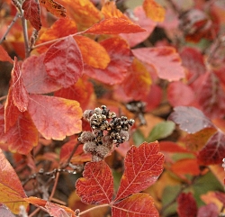
Three-leaf sumac is a low spreading, many-branched deciduous shrub, usually no more than 3 feet high but spreading as much as 8 feet wide. The small, trifoliate leaves and the branches are fuzzy. Given its many branches, three-leaf sumac provides both nesting material and structure for native bees. Flowers are yellowish and found in clustered spikes. They are followed by bright crimson to reddish, sticky berries. The fall foliage adds an extra pop of color to the landscape.

Three-Leaf-Sumac Rhus-trilobata, Photo courtesy Hansen's Northwest Native Plant Database, nwplants.com, Licensed Creative Commons Attribution-ShareAlike 3.0 Unported License
Three-Leaf-Sumac Rhus-trilobata
Photo courtesy Hansen’s Northwest Native Plant Database, nwplants.com Licensed under Creative Commons Attribution-ShareAlike 3.0 Unported License
Historically, three-leaf sumac has been used for medicinal and other purposes. The bark can be chewed or brewed into a drink for cold symptoms. Flexible branches were traditionally used for twisting into basketry and rugs. In fact, three-leaf sumac was a close contender to willow in desirability for basket-making. This common use of the plant earned it another nickname of “basketbush.”

My favorite part of three-leaf sumac, however, are the slightly hairy and sticky berries. Although historically eaten for gastrointestinal pain and toothache, the berries have a delicious sour flavor and can be eaten plain or used in oatmeal, ice cream, steeped in tea, or soaked in cold water to make a beverage similar to lemonade. These berries are high in vitamin C and have earned three-leaf sumac the additional nicknames of “sourberry” “lemonade bush” and “lemonade berry.” Other nicknames for this multi-purpose plant include squawbush, desert sumac, or scented sumac.

Regardless of which nickname you choose for three-leaf sumac, give the berries a try and see for yourself what you think! Be sure, however, that you properly identify the plant to avoid potential illness that can be caused by misidentification! One great resource that can help is the field guide “Rocky Mountain States: Wild Berries & Fruits.”

Three-Leaf-Sumac Rhus-trilobata, Photo courtesy Hansen's Northwest Native Plant Database, nwplants.com, Licensed Creative Commons Attribution-ShareAlike 3.0 Unported License
Three-Leaf-Sumac Rhus-trilobata
Photo courtesy Hansen’s Northwest Native Plant Database, nwplants.com Licensed under Creative Commons Attribution-ShareAlike 3.0 Unported License
For Utah State University Extension Sustainability, this is Roslynn Brain.

Credits:
Images: Courtesy Hansen’s Northwest Native Plant Database, nwplants.com, https://www.nwplants.com/business/catalog/rhu_tri.html,
Creative Commons Attribution-ShareAlike 3.0 Unported License
Text:     Roslynn Brain, Utah State University Extension Sustainability


Additional Reading:

Rhus trilobata, Three-leaf Summac, Plants of the Southwest, https://plantsofthesouthwest.com/products/rhus-trilobata?variant=11501394117

Rhus trilobata, Three-leaf Summac, Plant Database, Natural Resources Conservation Service, USDA, https://plants.usda.gov/core/profile?symbol=rhtr

Rhus trilobata, Three-leaf Summac, Lady Bird Johnson WildflowerCenter, University of Texas at Austin, https://www.wildflower.org/plants/result.php?id_plant=RHTR

Conservation: North and South

St George Winter Bird Festival, Courtesy St. George City
St. George Winter Bird Festival
Courtesy St. George City
I spent 2 gloriously warm days in Dixie where I attended the Winter Bird Festival, a grand event by any measure! I also had the good fortune of discovering “Citizens for Dixie’s Future” (henceforth CDF) which has taken on the onerous task of brokering piece between a surging population and the regions limited natural resources. Water topped the list, especially the Lake Powell Pipeline proposal. So I did a bit of reading from CDF’s well stocked library.

It soon became apparent that this multi-billion dollar project needs closer inspection on cost vs benefits. The costs must include not only dollars, but some unintended consequences such as continued urban sprawl in a super sensitive Mojave Desert ecosystem with an abundance of plant and animal life that I became more aware of through an excellent WBF presentation by naturalist educator Marshall Topham on the biodiversity of Washington County.

Citizens for Dixie’s Future
Courtesy Citizens for Dixie’s Future

Located at the confluence of 3 major biomes- Great Basin Desert, Mojave desert, and the Colorado Plateau intersected by numerous rivers and the towering Pine Valley Mountains, Washington County is a wildlife mecca with over 350 species of birds listed, an excellent indicator of its natural wealth.

So my naturalist instincts and a propensity towards frugality led me to look for pipeline alternatives.

I found conservation to be the most obvious and least expensive alternative. In 2009, Washington County was at or near the top in the West for per capita water use at 294 gallons per day. In dramatic contrast Tucson was 161 and golf course and fountain studded Vegas at 222. If the county was to set a goal for 1% reduction in water use per annum, it would negate the need for the pipeline according to CDF.

We notherners in Cache County are being threatened with a similar situation. Our Bear River which supplies 60% of the surface flow into the Great Salt Lake and is the primary source for the Bear River Migratory Bird Refuge is under scrutiny for multibillion dollar reservoir development to serve the Wasatch Front. In addition to the hefty price tag, this has very serious implications for loss of prime agriculture land and high value wildlife habitat.

The following conservation practices are taken from the CDF.

• Providing rebates for efficient indoor water fixtures and outdoor landscape conversion
• Adding native, drought tolerant landscaping in new developments (and converting old)
• Implementing an increasing rate structure to signal conservation to the customer
• Conservation programs must include numeric targets and performance measures
• Updating building codes with more aggressive plumbing and appliance standards
• Increasing education and awareness about reducing peak water use.
• Implementing smart growth principals and preventing sprawl

An additional conservation possibility being explored by some USU folks is restoring healthy populations of beaver to the Bear River Watershed. This has potential for water storage rivaling planned reservoirs not to mention the supurb wildlife habitat created as a bonus. A question for the Dixie folks- how are the beaver populations in the Beaver Dam and Pine Valley mountains fairing?

This is Jack Greene for Wild About Utah.

Credits:
Image: Courtesy St George Bird Festival, St. George City and Citizens for Dixie’s Future
Text:     Jack Greene, Bridgerland Audubon Society

Additional Reading:

Citizens for Dixie’s Future, https://citizensfordixie.org/

Big Bend Habitat Restoration Project: A Natural Work of Heart, Open Spaces-A Talk on the Wild Side, US FWS, https://www.fws.gov/news/blog/index.cfm/2016/3/25/Big-Bend-Habitat-Restoration-Project-A-Natural-Work-of-Heart [Accessed March 31, 2016]